Lighthouses of Saint Martin

This page includes lighthouses of two small territories, one of France and one of the Netherlands, located in the Leeward Islands at the northeastern corner of the Caribbean Sea. The island of Saint Martin is located in the northern part of the Leeward Islands about 13 km (8 mi) south of Anguilla and 30 km (19 mi) northwest of St.-Barthélemy. The hilly and irregular island is roughly 10 km (6 mi) in diameter. It is unique among the Lesser Antilles in having been divided between two colonial powers. Since 1648 France has occupied the northern portion of the island (roughly 3/5 of the whole), known as Saint-Martin, while the Netherlands has occupied the southern portion, known as Sint Maarten. Marigot is the capital and largest town of French Saint-Martin, and Philipsburg is the capital and largest town of Sint Maarten. The island's population is about 75,000, with 35,000 in the French territory and 40,000 in the Dutch territory.

The two French territories of Saint-Martin and Saint-Barthélemy were formerly governed as dependencies of the larger island of Guadeloupe but since 2007 they have reported separately to Paris as collectivités of France. The Dutch territory of Sint Maarten was attached administratively to the Netherlands Antilles for many years but in October 2010 it became a separate state, a "constituent country" of the Kingdom of the Netherlands.

Saint Martin was heavily damaged by Hurricane Irma in September 2017.

Most of the lighthouses of the Lesser Antilles are very poorly known, so information about them would be welcome and photos are especially welcome.

ARLHS numbers are from the ARLHS World List of Lights. Admiralty numbers are from volume J of the Admiralty List of Lights & Fog Signals. U.S. NGA numbers are from Publication 110.

General Sources
Online List of Lights - Saint-Martin and Sint Maartin
Photos by various photographers posted by Alexander Trabas.
World of Lighthouses - Saint-Martin and Sint Maarten
Photos by various photographers available from Lightphotos.net.
Saint Martin Map
Wikipedia's map helps us understand the division of the islandd.
GPSNauticalCharts
Navigational chart information for Saint Martin.
Navionics Charts
Navigational chart for Saint Martin.
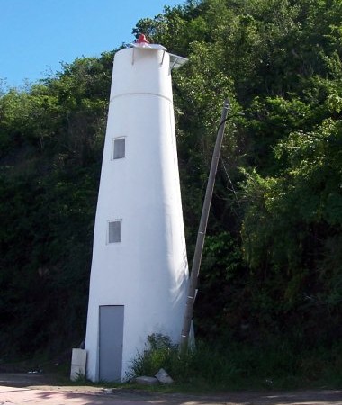
Feu de Marigot
Marigot Light, St.-Martin, January 2010
photo copyright Rosalie Beasley; used by permission
Saint-Martin Lighthouses
* Marigot
Date unknown (station established 1886). Active; focal plane 20 m (66 ft); flash every 4 s, white, green or red depending on direction. 10 m (33 ft) round conical tower painted white. No lantern. Rosalie Beasley's photo is above, Roger Theriault has a photo, another closeup photo is available, Trabas has a view by Arno Siering, and Google has a satellite view. This leading light guides vessels into the harbor of Marigot. A 1904 light list describes a white mast on the southwest corner of an old fort. Located across the road from the base of the breakwater mole of the harbor of Marigot, the principal town of the French portion of the island of Saint-Martin, on the northwestern coast of the island. Site open, tower closed. ARLHS STM-001; Admiralty J5658; NGA 14732.
[Galisbay Jetty]
Date unknown. Active; focal plane 10 m (33 ft); three flashes evry 12 s, white, red or green depending on direction. Approx. 6 m (20 ft) unpainted concrete pylon topped by a white mast. Google has an indistinct satellite view. Located on a short jetty at the north entrance to the Baie de Marigot. Site and tower closed but the light is easy to see from nearby. Admiralty J5657.7; NGA 14731.5.

Sint Maarten Lighthouses

* #[Groot Baai (Sint Maarten)] (3?)
Date unknown (station established 1876). Inactive since 2007 at least. The light was formerly on a post mounted on a short square tower atop the ruins of Fort Amsterdam. A February 2008 photo shows it removed and a 2023 photo by Wolken Gutierrez shows that all traces of the light have been removed. Google has a satellite view. of the location. Findlay's 1879 light list describes a "small light on old Fort Amsterdam." Located atop a narrow promontory on the west side of the entrance to Philipsburg harbor. Site open. ex-Admiralty J5660; ex-NGA 14724.
* Philipsburg (Leading Light)
Date unknown. Inactive since 2019. Approx. 27 m (90 ft) square skeletal communications tower. Trabas has Rainer Arndt's photo, another photo is available, and Bing has an indistinct satellite view. Located behind the Central Bank of Curaçao building in downtown Philipsburg. Site open, tower closed. ex-Admiralty J5661.5.

Information available on lost lighthouses:

Adjoining pages: North: Anguilla | Southeast: St.-Barthélemy | South: Saba and Sint Eustatius

Return to the Lighthouse Directory index | Ratings key

Posted December 8, 2005. Checked and revised January 17, 2024. Lighthouses: 2. Site copyright 2024 Russ Rowlett and the University of North Carolina at Chapel Hill.