Lighthouses of Taiwan: Matsu and Kinmen

In 1949 the withdrawal of Nationalist forces from mainland China led to a new governmental separation between Taiwan and the mainland, with the Nationalist government, the Republic of China (Zhōnghuá Mínguó, 中華民國), on Taiwan and the Communist government (the People's Republic of China) on the mainland. This separation continues to the present day. After leaving the mainland Nationalist forces remained in occupation of two groups of strategically placed islands close to the mainland coast opposite Taiwan. The Matsu Islands lie off the mainland port of Fuzhou and the Kinmen Islands lie off the port of Xiamen (formerly called Amoy). Kinmen is called Jīnmén on the mainland and Westerners formerly knew it as Quemoy ("Quemoy" is Westernized from the islands' name Kim-mûi in the Southern Min dialect spoken on this coast.)

Although Matsu and Kinmen continue to be governed from Taiwan, these islands historically were part of the mainland province of Fujian (Fukien) and not part of Taiwan province. For many years the islands were on the front lines of the Cold War, but tensions have relaxed somewhat. Outside the military bases Matsu and Kinmen are open to tourism, including tourists from the mainland.

Lighthouses in Taiwan are operated by the Maritime and Port Bureau. The Bureau has adopted a program to restore and develop the light stations as tourist attractions.

There are many languages and dialects spoken in China, but Standard Chinese, often called Mandarin, is the primary language in Taiwan as it is on the mainland. The Chinese word for a lighthouse is dēngtǎ (灯塔). Jiao or chiao is a cape, dao, tao, yu, or hsu is an island, wan is a bay, and kang or gang is a harbor. Due to competing systems for transliterating Chinese into Latin characters there are always several possible spellings for the names of places in China. The Wade-Giles system was in use in Taiwan for many years, but at the beginning of 2009 the Pinyin system used on the mainland became the standard in Taiwan as well. At the present time most place names in Taiwan are still known under their Wade-Giles spellings.

ARLHS numbers are from the ARLHS World List of Lights. Admiralty numbers are from volume P of the Admiralty List of Lights & Fog Signals. U.S. NGA List numbers are from Publication 112.

General Sources
Lighthouses in Taiwan
Wikipedia checklist, useful for its Pinyin spellings.
Lighthouses in Taiwan
Photos by various photographers available from Wikimedia.
Online List of Lights - China
Photos by various photographers posted by Alexander Trabas.
Leuchttürme auf Briefmarken
Postage stamp images posted by Klaus Huelse.
Navionics Charts
Navigation chart for the Taiwan Strait.


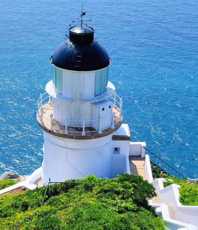
Dongyin Light, Matsu, August 2023
Instagram photo by Allen Whang
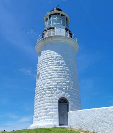
Lienchiang County: Matsu Islands Lighthouses
The Matsu Islands are located about 190 km (118 mi) west of Taiwan and 25 km (15 mi) off the mainland coast near Fuzhou. There are 19 islands, scattered rather widely along 40 km (25 mi) of ocean parallel to the mainland. The population in 2016 was about 12,750.
*** Dongyin (Tungyin Tao, Dongyong)
1902. Reactivated (inactive 1958-1989); focal plane 98 m (320 ft); three white flashes every 15 s. 14 m (46 ft) round cylindrical brick tower with lantern and gallery. Lighthouse painted white, lantern dome black. This is a staffed station. Allen Whang's 2023 photo is above, Yueh Hua Lee has an excellent photo, Guo Xinyou has a good photo, Wikimedia has a photo by Ying-lung Lu, and a second photo, Jung Yi Hung has a closeup street view, and Google has an indistinct satellite view of the station. This historic lighthouse was built by British engineers for the Chinese Imperial government. It was repaired after being badly damaged by Typhoon Alice in September 1995. The fog signal was deactivated in 2008. In 2016 the lighthouse was declared a national historical monument. The lighthouse is built on a cliff and is accessed by a steep staircase descending from the keeper's house. Dongyin is the northeasternmost island of the Matsu group, located about 50 km (30 mi) from the Chinese mainland. The island is accessible by air and by ferry from Keelung; it has a permanent population of about 1300. Located on the northeastern tip of the island. Site open, tower open daily except Mondays year round. . ARLHS TAI-034; Admiralty P3644; NGA 19090.
* Hou Ao (Nangan) North Jetty
Date unknown. Active; focal plane about 15 m (49 ft); green light, pattern unknown. Approx. 11 m (36 ft) post atop a round tower. Entire lighthouse is green. Gianni Wok has a street view showing the upper portion of the light and Google has an indistinct satellite view. Nangan is near the middle of the Matsu group and is the county seat for the islands. Located at the end of the main jetty at Nangan. Appears accessible by walking the pier. Site open, tower closed. Admiralty P3634.34.
*** Dongju (Dongjyu, Tungchu Tao, Dongquan)
1872. Active; focal plane 78 m (256 ft); three white flashes, in a 1+2 pattern, every 20 s. 19.5 m (64 ft) round cylindrical granite tower with lantern and gallery. Lighthouse painted white, lantern dome black. 2nd order clamshell Fresnel lens in use. This is a staffed station. Xu Chongyu's photo is at right, Morley Lo has a closeup, Chen Hsin-Ming has a 2020 photo, Huelse has a postage stamp image, Yang Changxun has a street view, and Google has a satellite view. Amy Chang's June 2007 photo shows the lighthouse surrounded by scaffolding, probably for repainting. Built by British engineers Robert Hart and David M. Henderson, this classic lighthouse guided ships to Fuzhou, one of the ports opened to Western trade following the end of the Second Opium War in 1860. Dongju (Dongjyu) is the southernmost of the Matsu Islands; it lies about 25 km (15 mi) off the entrance to Fuzhou. The island has a permanent population of about 200 and is accessible several times a day by passenger ferry from the larger island of Nangan. However, there are no overnight accommodations for visitors and much of the island is occupied by military installations. Located on the northeastern point of the island, which is also the highest point. Site open, tower open daily except Mondays year round. . ARLHS TAI-032; Admiralty P3634; NGA 19132.

Dongju (Dongjyu) Light, Matsu, June 2022
Google Maps photo by Xu Chongyu

Kinmen County: Wuqiu Islands Lighthouse
The Wuqiu Islands are isolated 72 km (45 mi) northeast of Kinmen (Quemoy) and 22 km (13.5 mi) southeast of Nanri Island in the People's Republic. In 2018 the population of the islands was 685.
Wuqiu (Wuciou, Wuchiu, Wuchio Yu, Wuchin Hsu, Ockseu (2?)
1874. Reactivated (inactive 1951-2017); focal plane 87 m (285 ft); white flash every 5 s. 19.5 m (64 ft) round cylindrical stone tower with lantern and gallery. Lighthouse painted black. This is a staffed station. A 2018 photo is available, Wikipedia has a photo, Xu Chaoming has a distant view, and Google has a satellite view. Damaged during the revolutionary war in 1948, this lighthouse was inactive for many years even though it was never dropped from the international lists. It must have been rebuilt since it does not resemble many historic photos. It was reactivated in a ceremony on 23 July 2017 and has been nominated for recognition as a national historic site. The lighthouse is on the highest point of Daqiu ("Big Qiu"), the largest of the Wuqiu Islands. Site and tower closed (military area). . ARLHS TAI-035; Admiralty P3628; NGA 19124.

Kinmen County: Kinmen Islands Lighthouses
Kinmen (Jinmen) Island (Quemoy) is shaped like a bow tie about 20 km (13 mi) long. The north coast is within 8 km (5 mi) of the mainland: easy artillery range during the Cold War.

Beiding (Peiting Yu, Peiting Tao)
1882. Reactivated (inactive from World War II to 1975); focal plane 36 m (118 ft); two white flashes every 10 s. 18 m (56 ft) round brick tower with gallery, painted white. Lantern removed. This is a staffed station, crews serving 15 day shifts. Ian Chin has a 2021 photo, a Taipei Times article has a photo and some information about the station, and Google has a satellite view. The lantern was destroyed in World War II and replaced with a short skeletal tower in 1947. The lighthouse was renovated and reactivated in 1975. Beiding is a small island about 3 km (2 mi) off the eastern tip of Kinmen. Accessible only by boat; there may be distant views from the mainland of Kinmen. Site status unknown. ARLHS TAI-021; Admiralty P3620; NGA 19176.

Wuciou Light, Kinmen, July 2018
Google Maps photo by King Jacky
Kinmen South Breakwater
Date unknown. Active; focal plane about 14 m (46 ft); red light, pattern unknown. Approx. 12 m (39 ft) round red concrete tower. Guo Tingzong has a distant view, Phoebe Chiu also has a distant view, and Google has a satellite view. Located on the south breakwater of the port and ferry terminal at the west ed of Kinmen. Site status unknown. Admiralty P3612.05.
Kinmen North Breakwater
Date unknown. Active; focal plane about 14 m (46 ft); green light, pattern unknown. Approx. 12 m (39 ft) round green concrete tower. Zhu Ming has a 2022 photo, Zhang Yayi has a 2024 view from the sea, Liu Wenzong has a similar 2022 view, and Google has a satellite view. Located on the north breakwater of the port and ferry terminal at the west ed of Kinmen. Site status unknown. Admiralty P3612.08.
Liaoluo South Breakwater
Date unknown. Active; focal plane about 15 m (49 ft); red flash every 6 s. Approx. 12 m (39 ft) red mast centered on a square 1-story concrete pedestal. Chen Jianzhong has a closeup photo and Google has an indistinct satellite view. Liaoluo is an artificially-created port at the southeastern tip of Kinmen (as far from the mainland as possible). Located at the end of the south (main) breakwater of Liaoluo. Site status unknown. Admiralty P3620.08; NGA 19175.7.
Dongding (Tungting Tao, Tungting Hsu, Chapel Island)
1871. Active; focal plane 69 m (226 ft); white flash every 10 s. 19 m (62 ft) round brick tower with lantern and gallery, painted black. This is a staffed station. A photo is at right and Google has an indistinct satellite view. The lighthouse survived World War II but it had to be repaired in 1964 after being damaged by artillery bombardment from the mainland. Dongding is a small island about 13 km (8 mi) off the mainland coast and 25 km (15 mi) south southwest of Kinmen. Accessible only by boat. Site status unknown. ARLHS TAI-033; Admiralty P3606; NGA 19196.

Information available on lost lighthouses:

Notable faux lighthouses:


Dongding Light, Kinmen, May 2018
Google Maps photo by sunny baby
 

Adjoining pages: North: Fuzhou | East: Western Taiwan | South: Xiamen | West: Central Fujian

Return to the Lighthouse Directory index | Ratings key

Posted September 11, 2007. Checked and revised March 21, 2024. Lighthouses: 9. Site copyright 2024 Russ Rowlett and the University of North Carolina at Chapel Hill.