Lighthouses of the Northern Mariana Islands

The Mariana Islands are a chain of islands stretching north to south in the northwestern Pacific Ocean. Guam is the largest and southernmost of the islands; Saipan, Tinian, and Rota are the other principal inhabited islands. The Marianas were colonized by Spain beginning in 1668 and they continued under Spanish control until the Spanish-American War of 1898. The U.S. captured and annexed Guam during that war, but Spain transferred all the other islands to Germany. Japan then seized the Northern Marianas from Germany in 1915, during World War I, and moved quickly to establish a naval base on Tinian. During World War II the U.S. captured the islands of Saipan and Tinian in very hard fighting in 1944.

After the war, the U.S. administered the Northern Marianas along with Palau and the Caroline and Marshall Islands as the Trust Territory of the Pacific Islands. In the 1970s, when the U.S. moved to grant independence to these territories, the people of the Northern Marianas decided instead to continue their association with the U.S. as a self-governing commonweath. An agreement in 1975 paved the way for the establishment of the Commonwealth of the Northern Mariana Islands (CNMI) in 1978. The capital of the CNMI is on Saipan; the population of the commonwealth is about 55,000.

Navigational aids in the Northern Marianas are maintained by the U.S. Coast Guard Sector Guam.

ARLHS numbers are from the ARLHS World List of Lights. Admiralty numbers are from volume M of the Admiralty List of Lights & Fog Signals. U.S. NGA List numbers are from Publication 111. USCG numbers are from Volume VI of the U.S. Coast Guard Light List.

General Sources
Japanese Lighthouse
This is the Facebook page for the historic Garapan lighthouse on Navy Hill.
World of Lighthouses - Northern Mariana Islands
Photos by various photographers available from Lightphotos.net.
Online List of Lights - Northern Mariana Islands
Photos by various photographers posted by Alexander Trabas.
NOAA Nautical Chart Locator
Nautical charts for the island can be viewed online. Chart 81067 covers Saipan and Tinian and Chart 81076 covers Saipan harbor.
U.S. Coast Guard Navigation Center: Light Lists
The USCG Light List can be downloaded in pdf format.
Navionics Charts
Navigation chart for Saipan and Tinian.


Garapan (Mariana) Light, Saipan, January 2021
ex-Wikimedia Creative Commons photo by rambler.panoramio

Saipan Lighthouses
[Mañagaha Island]
Date unknown. Active; focal plane 23 m (75 ft); continuous light, white, red or green depending on direction. Approx. 12 m (39 ft) post carrying a diamond-shaped black and white checkered daymark. No photo available and Google has only a distant satellite view. This is the approach light for Saipan. Located in a densely forested park on a small island on the north side of Saipan harbor. Accessible only by boat. Site status unknown. Admiralty M8364; NGA 10955; USCG 6-30865.
Tanapag Harbor Range Front
Date unknown. Active; focal plane 16 m (52 ft); quick-flashing green light. Approx. 14 m (46 ft) round cylindrical white tower carrying a rectangular red daymark with a white vertical stripe. Google has a distant street view and a distant satellite view. This is the entrance range for the harbor. Located on the waterfront. Site status unknown. Admiralty M8366; NGA 10956; USCG 6-30875.
Tanapag Harbor Range Rear
Date unknown. Active; focal plane 38 m (126 ft); green light, 3 s on, 3 s off. Approx. 14 m (46 ft) white square skeletal tower carrying a rectangular red daymark with a white vertical stripe. Google has a street view and a distant satellite view. Located on a forested hillside 922 m (0.57 mi) east of the front light. Site status unknown. Admiralty M8366.1; NGA 10960; USCG 6-30880.
*** Garapan (Mariana)
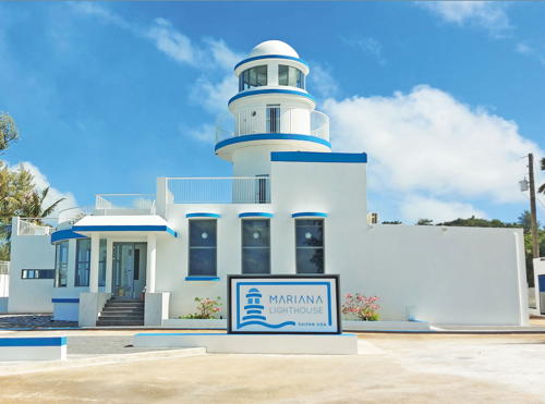
1934. Inactive since 1944 but the lighthouse is floodlit at night. Approx. 15 m (50 ft) concrete tower rising from a 1-story concrete keeper's quarters. A photo is at the top of this page, another 2021 photo is available, and Google has a satellite view. The lighthouse is one of several built by Japan to guide its ships to its bases in the central Pacific prior to World War II. A photo and a second photo show the heavy damage the lighthouse suffered during the three-week Battle of Saipan in late June and early July 1944. However the U.S. Navy's 117th Naval Construction Battalion quickly restored the lighthouse so that it could be used as a signal station; Michel Forand has posted a photo of the restored building. The lighthouse was placed on the U.S. National Register of Historic Places in 1974. The building was renovated and expanded in the early 1990s as a restaurant, but it was abandoned after 1995 and fell in increasingly poor condition. Paul Sturm and other island residents formed the Saipan Lighthouse Historical Society to work for its restoration. For a time, volunteers met regularly to clean up the lighthouse and fix what they could. However, Eric Johnson's June 2009 photo and Kerry Hill's August 2011 photo show no major change in the building. Wikimedia has a 2009 photo, and Google has a 2014 street view. In 2010 Congress appropriated $192,000 for an engineering study of the lighthouse as the proposed visitor center of the newly-created Mariana Trench Marine National Monument. However, it appears that the building is too small for this purpose. In 2016 the dome fell from the tower during a storm. In August 2017 a resident (D.C. Cook) wrote in a local newspaper that he was interested in attempting to restore the lighthouse once again as a restaurant, if investors could be found. In the same year there was a proposal to restore the lighthouse as the Chamorro Cultural Center (the Chamorros are the indigenous residents of the Marianas). None of these ideas came to fruition. Finally, in 2018 Korean businessman Bong Heung Lee, CEO of Bibong Corp., visited the lighthouse and was struck by its potential for development as a cultural tourist attraction. In 2020 Bibong completely restored and partially rebuilt the lighthouse, and in 2021 it opened as the Mariana Lighthouse. There is a coffee shop and gift shop inside, and a bar and restaurant with seating outside. Located on the highest point of Navy Hill behind the town of Garapan, the capital of the Northern Mariana Islands, on the western side of Saipan. Owner: Northern Marianas Department of Public Lands. Site manager: Mariana Lighthouse . Site and tower open. ARLHS MAI-001.

Tinian Lightbeacon
* [Ushi Point]
Date unknown. Active; focal plane 5.5 m (18 ft); continuous light, white flash evry 2.5 s. Approx. 4 m (13 ft) post carrying a diamond-shaped black and white checkered daymark. Google has a street view but the small light is not seen in Google's satellite view. Located on Puntan Tahgong, the northern tip of Tinian, marking the Saipan Channel passage between Tinian and Saipan. Accessible by hiking or 4WD. Site open, tower closed. Admiralty M8371; NGA 10961; USCG 6-30919.

Information available on lost lighthouses:

Notable faux lighthouses:

Adjoining pages: North: Nanpō Islands | South: Guam

Return to the Lighthouse Directory index | Ratings key

Posted August 28, 2005. Checked and revised September 5, 2023. Lighthouses: 3. Site copyright 2023 Russ Rowlett and the University of North Carolina at Chapel Hill.