Lighthouses of Mauritania

The Islamic Republic of Mauritania is a thinly populated nation of the Sahara Desert located on the northwestern coast of Africa between Morocco and Sénégal. The country's coastline is 750 km (465 mi) long but has only two ports, Nouakchott and Nouâdhibou. France colonized the country in the first years of the 20th century and maintained control until Mauritania became independent in 1960. The French colony was administered from Saint-Louis in neighboring Sénégal, and it was only at the time of independence that the previously-tiny fishing village of Nouakchott was identified and developed as the capital of the country. The port and railway terminal of Nouâdhibou (formerly called Port-Étienne) was developed to ship iron ore from mines at Zouîrât.

Arabic and French are official languages in Mauritania. The Arabic word for a lighthouse is mnarh or manara (منارة). Ra's is the word for a cape or headland. The French word for a lighthouse is phare, although a smaller light or harbor light is called a feu (literally "fire," but here meaning "light") or a balise (beacon). In French île is an island, cap is a cape, and pointe is a promontory or point of land.

Aids to navigation in Mauritania are maintained by the port authorities of Nouakchott and Nouâdhibou, respectively.

ARLHS numbers are from the ARLHS World List of Lights. Admiralty numbers are from volume D of the Admiralty List of Lights & Fog Signals. U.S. NGA List numbers are from Publication 113.

General Sources
Online List of Lights - Mauritania
Photos by various photographers posted by Alexander Trabas.
World of Lighthouses - Mauritania
Photos by various photographers available from Lightphotos.net.
Lighthouses in Mauritania
Photos by various photographers available from Wikimedia.
Afrikanischen Leuchttürme auf historischen Postkarten
Historic postcard images posted by Klaus Huelse.
Navionics Charts
Navigation chart for Mauritania.


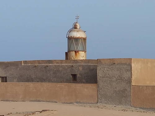
Cap Blanc Light, Nouâdhibou, April 2022
Google Maps photo by Giulio Aprin
Nouakchott Lighthouses
At the time of independence in 1960 the tiny village of Nouakchott was selected as the national capital and site of a new port. In the 1980s Chinese engineers built a large groin perpendicular to the coast on the south side of the new city. The groin traps southward-moving sand to create a wide beach for the town to the north and an open harbor to the south. At the end of the groin a large breakwater wharf arcs southwestward to provide an artificial shelter for ocean-going ships. This facility is called Port de l'Amitié (Friendship Port). The port authority is known by the acronym PANPA.

FPSO Berge Helene
Date unknown. Active; focal plane about 24 m (79 ft); white light, characteristic unknown. Light mounted on an approx. 17 m (56 ft) skeletal tower mounted near the bow of the supertanker Berge Helene. Trabas has a photo by Darian Sclaunich. Built in 1976, the ship was converted in 2002 to an FPSO (Floating Production, Storage, and Offloading) vessel. Anchored over the Chinguetti oil field, the ship pumps up to 60,000 barrels of oil per day and stores the oil until offloaded (about once a month) by a tanker. Located about 80 km (50 mi) southwest of Nouakchott. Accessible only by boat. Vessel closed. Admiralty D2991.
Port de l'Amitié Range Rear (2?)
Date unknown. Active; focal plane 22 m (72 ft); green light, 0.5 s on, 0.5 s off. Approx. 20 m (66 ft) skeletal tower carrying a diamond-shaped daymark colored green and gray. NGA describes the light as being on a mast, but Google's satellite view shows the skeletal tower. No photo available. The front light is indeed on a mast. Located just behind the south end of the port facilities. Site status unknown. Operator: Port Autonome de Nouakchott. Admiralty D2986.31; NGA 24373.2.
Port de l'Amitié West Pier
Date unknown. Active; focal plane about 12 m (39 ft); red light, pattern unknown. Approx. 9 m (30 ft) square concrete tower. no photo available but Google has a satellite view. Located at the end of the outermost pier of the port. Site and tower closed. Operator: Port Autonome de Nouakchott. Admiralty D2986.7.
Nouakchott Approach (Port de l'Amitié)
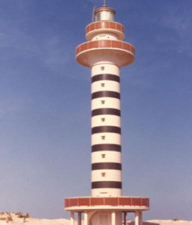
1980s? Active; focal plane 37 m (121 ft); white light, 5 s on, 5 s off. Roughly 30 m (98 ft) round cylindrical tower with lantern and double gallery, painted white with red trim and narrow black horizontal bands. The photo at right is by one of the Chinese companies developing and operating the harbor. A.D. Thomsen has a 2019 view from the harbor, Rupesh Usadadiya has a distant 2024 view, and the Degree Confluence Project has a photo taken by J. Baker Hill from exactly 18°N 16°W, about 1 km (0.6 mi) east of the lighthouse. Google has a satellite view. The lighthouse is in the midst of the port facilities. Site and tower closed. Operator: Port Autonome de Nouakchott. ARLHS MAU-004; Admiralty D2986; NGA 24373.

Nouakchott Light
photo (no longer online) by CCCC First Harbor Consultants Co.

Nouâdhibou Lighthouses
Nouâdhibou (called Port-Étienne under French control) is at the extreme northern end of Mauritania's coast. It is a major port for the shipment of iron ore from the Zouîrât mines 480 km (300 mi) to the west. The harbor is sheltered by the hook-shaped peninsula of Cap Blanc (Ras Nouâdhibou). The western shore of the peninsula is in the former Western Sahara, now claimed by Morocco, but the whole of the peninsula is actually occupied by Mauritania.

Pointe Chacal (Nouâdhibou)
Date unknown. Active; focal plane 20 m (66 ft); white, red, or green light, depending on direction, 2 s on, 2 s off. 12 m (39 ft) octagonal tower, painted with black and white vertical stripes. Hamoud Mohamed has a street view, Andrius Rybakovas has an aerial view (the lighthouse is at top center), and Google has a satellite view. This leading light guides ships on a west northwest course into the harbor. Located within the harbor facilities. Site and tower closed. Operator: Port Autonome de Nouâdhibou. ARLHS MAU-002; Admiralty D2980; NGA 24364.
* Pointe de Cansado
Date unknown (station established 1913). Active; focal plane 20 m (66 ft); quick-flashing white light; red flashes are shown over a sector to the southeast. Approx. 8 m (26 ft) lantern mounted on the flat roof of a small 1-story keeper's cottage. A 2009 photo is at right, Med Moctar Moctar has a distant 2023 view, and Google has a satellite view. Cansado is the location of several hotels used by visitors to Nouâdhibou. Located on a sandy point on the east side of the Cape Blanc peninsula about 7 km (4.5 mi) south southeast of Nouâdhibou. Site open, tower closed. Operator: Port Autonome de Nouâdhibou. ARLHS MAU-003; Admiralty D2979; NGA 24360.
* Cap Blanc (Ras Nouâdhibou)
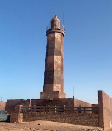
1910. Active; focal plane 43 m (141 ft); white flash every 5 s. 20 m (66 ft) octagonal tower with lantern and gallery, mounted on a square base, painted with black and white horizontal bands. Lantern removed. Giulio Aprin's 2022 photo is at the top of this page, Jean-Baptiste Dodane has a 2013 photo, Fabrizio Sommaruga has a 2011 photo, Alimata Deme has a 2021 photo, Trabas has a distant photo by Capt. Peter Mosselberger, a 2022 drone view is available, J.P.C. van Heijst has an aerial photo, the Degree Confluence Project has a wider view showing the lighthouse and the point of the cape, and Google has a satellite view. Older photos show that the lighthouse was without its lantern for many years. It was restored in 2009 by a Spanish company, La Maquinista Valenciana. Huelse has a historic postcard view of the lighthouse with its original lantern. The great bulge of West Africa ends in two prominent capes, Cap Blanc in Mauritania and Cap Vert in Senegal. European explorers named them, respectively, the "white cape" for its desert sands and the "green cape" for the vegetation that begins to appear farther south. The White Cape is a long, sandy peninsula sheltering the Baie de Nouâdhibou, the only naturally protected harbor on the Mauritanian coast. Mauritania's northern border runs down the middle of the peninsula. The lighthouse is located near the tip of the peninsula, only a few feet from the international frontier. Site open, tower closed. Operator: Port Autonome de Nouâdhibou. ARLHS MAU-001; Admiralty D2977; NGA 24340.
Phare de Cansado
Pointe de Cansado Light, Nouâdhibou, April 2009
ex-Panoramio photo copyright leonarti; used by permission
* Ras Nouâdhibou South
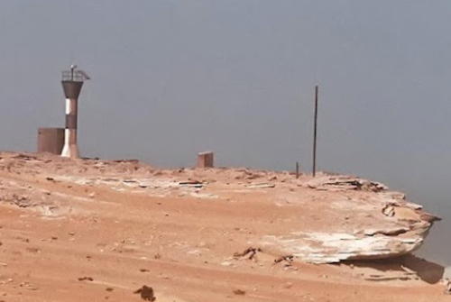
2009. Active; focal plane about 25 m (82 ft); white, red or green light depending on direction, pattern unknown. Approx. 13 m (43 ft) round barbell-shaped tower, colored with black and white horizontal bands. Part of a distant 2023 view by Andrius Rybakovas is at right, Lightphotos.net has a 2013 photo, Sergio Formoso's photo was taken in December 2009, Jean-Baptiste Dodane has a photo showing the new light behind the Cap Blanc lighthouse, a 2022 drone view is available, and Bing has a distant satellite view. The light was installed by La Maquinista Valenciana as a leading light guiding vessels into the harbor. To avoid shoals vessels must approach from the southwest, then follow this leading light northward to reach the start of the harbor entrance channel. Located at the extreme point of Cap Blanc, about 150 m (490 ft) south of the lighthouse. Site open, tower closed. Not listed by international authorities.
* La Gouira (Punta Güera, La Agüera)
Date unknown. Inactive (listed with focal plane 14 m (46 ft); red flash every 5 s). 6 m (20 ft) square stone tower with gallery, unpainted. Ruins of a Spanish fort surround the rear of the lighthouse. Jamal Ait Sayed has a very distant view, and Google has a satellite view. This former Spanish lighthouse is located on a promontory on the west side of the Cap Blanc peninsula about 8 km (5 mi) northwest of the Cap Blanc lighthouse. The pre-1960 international border between the colonies of Spanish (Western) Sahara and French Mauritania runs down the length of the peninsula. Most of Western Sahara is now under the control of Morocco, with the rest in the hands of Sahwari insurgent forces. Neither Moroccan forces nor Sahwari forces occupy this extreme southern tip of the former Spanish Sahara, so it is administered de facto by Mauritania. Site open, tower closed. Admiralty D2976; NGA 24336.

Ras Nouâdhibou South Light, Nouâdhibou, September 2023
Google Maps photo by Andrius Rybakovas

Information available on lost lighthouses:

Notable faux lighthouses:

Adjoining pages: North: Southwestern Morocco | South: Sénégal

Return to the Lighthouse Directory index | Ratings key

Posted August 25, 2005. Checked and revised May 11, 2024. Lighthouses: 8; lightships: 1. Site copyright 2024 Russ Rowlett and the University of North Carolina at Chapel Hill.