Lighthouses of Nicaragua: Pacific Coast

The Republic of Nicaragua is a country of Central America located south of Honduras and north of Costa Rica. Spanning the isthmus, Nicaragua has coasts facing southwest on the Pacific Ocean and east on the Caribbean Sea. The most important port is Corinto, on the Pacific in the northwestern corner of the country. This page describes the lighthouses of the Pacific coast; there is a separate page for the Caribbean coast.

Nicaragua, like all of Central Ametica, gained independence from Spain in 1821, but it did not control the Caribbean coastal region until 1860, when Britain ceded its protectorate of the Mosquito Coast.

Nicaragua is divided into 15 departments (departamentos) and two self-governing "autonomous communities."

The Spanish word for a lighthouse is faro; isla is an island, cabo is a cape, punta is a promontory or point of land, péñon is a rock, arrecife is a reef, bahía is a bay, ría is an estuary or inlet, estrecho is a strait, río is a river, and puerto is a port or harbor. Also, the Spanish word canal means a natural channel, not an artificial canal.

Aids to navigation in Nicaragua are managed by the Aquatic Transport Directorate of the Ministry of Transportation and Infrastructure.

ARLHS numbers are from the ARLHS World List of Lights. Admiralty numbers are from volume G of the Admiralty List of Lights & Fog Signals. NGA numbers are from NGA Publication 111.

General Sources
Online List of Lights - Nicaragua
Photos by various photographers posted by Alexander Trabas.
World of Lighthouses - Nicaragua
Photos available from Lightphotos.net.
Other Regions of the World
Historic postcard views posted by Michel Forand.
Navionics Charts
Navigation chart for Nicaragua.

Cardón Light
Isla El Cardón Light, Corinto, May 2012
Flickr Creative Commons photo by Larry Myhre

Rivas Department Lighthouses
* San Juan del Sur
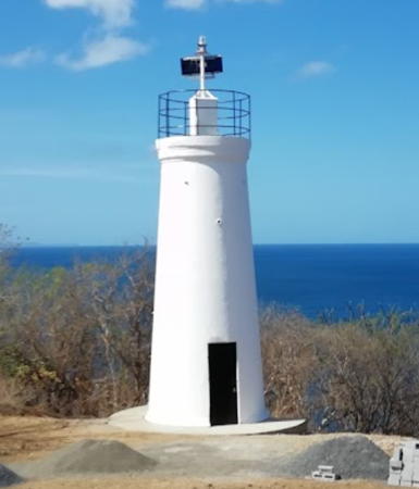
Date unknown (station established 1900). Active; focal plane 30.5 m (100 ft); white flash every 6 s. 4.5 m (15 ft) round cylindrical white tower. Lantern removed; beacon mounted on a short mast at the top of the tower. Lighthouse painted white. A photo is at right, Tobi Forsdyke has a 2017 photo, Lesly Cerpas has a 2022 photo, Ryan Anderson has a closeup, Frederik Demeyere has a view from the sea, Indio Jones has a 2017 street view, and the tower is seen in Google's satellite view. San Juan del Sur is a fishing port, also now a popular beach resort. The original light was described as "pyramidal." Located on a steep promontory about 2.5 km (1.5 mi) southwest of San Juan del Sur; accessible by a hiking trail from the town. Site open, tower closed. ARLHS NIC-004; Admiralty G3350; NGA 15440.
* [Head of Bay Range Front (2)]
Date unknown. Active; focal plane 10 m (33 ft); red flash every 6 s. 9 m (30 ft) post mounted on a waterfront building. Aaron Johnson has a closeup 2021 street view and Hugo Rodríguez has a street view from the beach, but the tiny light is not seen in Google's satellite view. Located on the beachfront of San Juan del Sur. Site open, tower closed. Admiralty G3351; NGA 15444.
* [Head of Bay Range Rear]
Date unknown. Active; focal plane 16 m (52 ft); continuous red light. Approx. 7 m (23 ft) white post. Aaron Johnson has a closeup 2021 street view and Google has a satellite view. Located 213 m (700 ft) northeast of the front light on the waterfront. Site appears open, tower closed. Admiralty G3351.1; NGA 15448.

Managua Department: Pacific Coast Lighthouse
* Masachapa
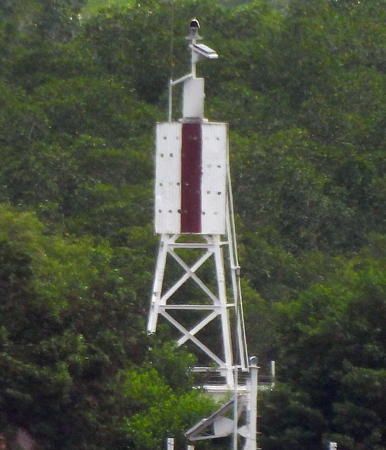
Date unknown. Active (unofficial; charted by Navionics); focal plane about 16 m (52 ft); white light, pattern unknown. Approx. 11 m (36 ft) round tower with a small lantern; the light is mounted on top of the lantern. Lighthouse painted gold with a purple spiral stripe; lantern painted white. Carlos Chamorro Schutze has a 2018 closeup photo, a more distant view, and a street view from the beach, Jeaneth Linares has a 2023 photo, and Google has a satellite view. Masachapa is a former fishing port, now a beach resort, in the municipality of San Rafael del Sur about 55 km (35 mi) southwest of Nicaragua's capital Managua. The town had to be rebuilt after being swept by a tsunami in September 1992. Located on the waterfront of Masachapa. Site open, tower closed. Not listed by the Admiralty.

San Juan del Sur Light, April 2018
ex-Google Plus photo by Joseph Pineda

León Department Lighthouse
Puerto Sandino
Date unknown. Active; focal plane unknown; white flash every 10 s. No description and nophoto available; Bing's indistinct satellite view suggests a skeletal tower perhaps 15 m (49 ft) tall. Puerto Sandino is a port about 70 km (44 mi) west of Managua. Prior to the overthrow of the Somoza dictatorship in 1979 it was known as Puerto Somoza. Located on a hillside above the town. Site status unknown. Admiralty G3351.4; NGA 15428.

Chinandega Department Lighthouses
Isla El Cardón (Morro Cardón, Corinto)
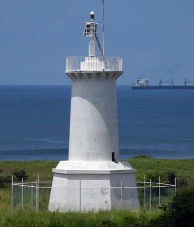
1876. Active; focal plane 26.5 m (87 ft); white light, 3 s on, 7 s off. 13 m (43 ft) white round cylindrical concrete tower with gallery, centered on a 1-story hexagonal base. Lantern removed. Larry Myhre's photo is at the top of this page, Trabas has Jim Smith's closeup photo, Rodrigo Castillo has a good photo, Michael Leydet has a photo, G.L. Donald has a 2017 photo, and Google has a satellite view. Next to the lighthouse is a statue of Nicaraguan poet Rubén Darío, an important figure in Spanish literary history. Forand has a historic postcard view. The sender of the card has written on it that the light was "installed by the Denver," a U.S. Navy cruiser that brought troops to occupy Corinto in the fall of 1912, during a period of political unrest in the country. This must have been a reactivation of the light. This historic tower is the oldest lighthouse in Central America. The port of Corinto was founded in 1863, but the first substantial development was in 1875-76 with the construction of a pier and this lighthouse. Located at the north point of Isla El Cardón, marking the entrance to the harbor of Corinto. Accessible only by boat. Site open, tower closed. ARLHS NIC-003; Admiralty G3352; NGA 15400.
Dona Paula Range Front
Date unknown. Active; focal plane about 9 m (30 ft); continuous green light. Approx. 8 m (26 ft) skeletal tower painted white. No photo available but Google has a satellite view. This is the second range guiding vessels into the bay of Corinto. Located at the edge of the water on the southeast side of the bay. Accessible only by boat. Site status unknown. Admiralty G3354; NGA 15412.
Dona Paula Range Rear
Date unknown. Active; focal plane about 15 m (49 ft); green flash every 4 s. Approx. 8 m (26 ft) skeletal tower attached or adjacent to a square equipment building. No photo available but Google has a satellite view. Located 810 m (1/2 mi) southeast of the front light. Accessible only by boat. Site status unknown. Admiralty G3354.1; NGA 15416.
Isla Encandada Range Front
Date unknown. Active; focal plane about 9 m (30 ft); continuous red light. Approx. 8 m (26 ft) skeletal tower painted white. No photo available but Google has a distant satellite view. This is the third range guiding vessels across the bay of Corinto. Located at the edge of the water on the Isla Encandada, a swampy island opposite the Corinto docks. Accessible only by boat. Site status unknown. Admiralty G3355; NGA 15420.
Isla Encandada Range Rear
Date unknown. Active; focal plane about 16 m (52 ft); continuous red light. Approx. 16 m (52 ft) skeletal (?) tower painted white. No photo available but Google has a satellite view. The satellite view is consistent with a concrete tower. Located 250 m (0.2 mi) east northeast of the front light. Accessible only by boat. Site status unknown. Admiralty G3355.1; NGA 15424.
* Corinto Entrance Range Front
Date unknown. Active; focal plane about 20 m (66 ft); continuous red light. Approx. 17 m (56 ft) square skeletal tower painted white. No photo available but Google has a satellite view. This is really the first (approach) range for Corinto. Located on the second street from the waterfront in downtown Corinto. Site open, tower closed. Admiralty G3353; NGA 15404.
Corinto Entrance Range Rear
Date unknown. Active; focal plane about 40 m (131 ft); continuous red light. Approx. 17 m (56 ft) square skeletal tower painted white. No photo available but Google has a satellite view. Located in an oil tank farm 720 m (0.45 mi) east northeast of the front light. Site and tower closed. Admiralty G3353.1; NGA 15408.
Islas Farallones
Date unknown. Active; focal plane unknown; quick-flashing white light. Approx. 15 m (49 ft) square cylindrical white masonry or concrete tower. Orlando Jarquín has the view from the sea seen at right and Google has an indistinct satellite view. The Farallones are a group of rocky islands rising dangerously in the entrance to the Gulf of Fonseca at the northwestern corner of Nicaragua. Located at the highest point of the group. Accessible only by boat. Site status unknown. Admiralty G3356; NGA 15398.

Islas Farallones Light, Gulf of Fonseca, November 2012
Google Plus photo by Orlando Jarquín

Managua Department: Lago Managua Lighthouse
* Puerto Salvador Allende
Date unknown. Active; focal plane about 15 m (49 ft); rotating white aerobeacon. Approx. 12 m (39 ft) 10-sided skeletal tower. Lizardo Cerna has a closeup photo, Moises Antonio Silva Cruz has a photo, Francisco Javier Gallegos Páez has a closeup street view, and Google has a satellite view. Located on the pier of the small craft port of Managua, the capital of Nicaragua which faces the south side of Lago Managua. Site appears open, tower closed.

Information available on lost lighthouses:

Notable faux lighthouses:

Adjoining pages: South: Costa Rica Pacific | West: El Salvador

Return to the Lighthouse Directory index | Ratings key

Checked and revised October 16, 2023. Lighthouses: 12. Site copyright 2023 Russ Rowlett and the University of North Carolina at Chapel Hill.