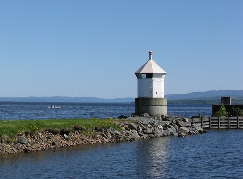
Lighthouses of Norway: Lake Mjøsa

Located about 100 km (60 mi) north of Oslo, Lake Mjøsa is Norway's largest lake. It extends north to south through the mountains for about 117 km (73 mi). Its greatest width is 15 km (9 mi) but for most of its length it is about 5 km (3 mi) wide. Navigation on the lake is receational except for the historic paddlewheel steamboat Skibladner, which sails between Eidsvoll at the southern end of the lake and Lillehammer near the northern end.

Norway is divided into 15 counties (fylker) and the counties are divided into townships (kommuner). In 2020 mergers decreed by the national government reduced the number of counties. Before the mergers the east side of the lake was mostly in Hedmark County and the west side was mostly in Oppland County. These two counties were merged to form a new county called Innlandet.

In Norwegian a lighthouse is a fyrtårn (fire tower) or simply a fyr; a fyrlykt is a beacon and a lyktehus is a lantern. Øy is an island, holmen is an islet, skjær is a skerry (a tiny island or rocky reef), sund is a strait (often between an island and the mainland), bukt is a bay, nes is a headland, and havn is a harbor.

Aids to navigation on the lake are privately maintained; they are not on the international light lists.

General Sources
Norwegische Leuchttürme
Photos by Klaus Huelse.
Navionics Charts
Navigation chart for the lake.


Gjøvik Light, Gjøvik, May 2008
ex-Flickr photo copyright Andreas Fritsche; used by permission

Lighthouses
* Hamar
Date unknown. Active; focal plane about 6 m (20 ft); white, red, or green light depending on direction, light pattern unknown. 4.5 m (15 ft) round cylindrical metal tower with lantern and gallery, painted white; lantern roof painted red. Huelse has a photo, Anton Aleksandrov has a drone view, Eric Okkelberg Olsen has a distant view, and Google has a satellite view. Located on an elbow of the breakwater sheltering a pleasure boat harbor at Hamar, on the east side of Lake Mjøsa. Accessible by walking the mole. Site open, and visitors can climb to the gallery. Owner/site manager: unknown.
* Brumunddal
Date unknown. Active; focal plane about 6 m (20 ft); red light, pattern unknown. 4 m (13 ft) round white fiberglass lantern with a blue roof. Roger Bakkehaug has a street view and Google has a satellite view. Located at the end of the west breakwater at Brumunddal on the northern end of the eastern branch of the lake. Accessible by walking the mole. Site open, tower closed.
* Gjøvik
Date unknown. Active; focal plane about 6 m (20 ft); green light, pattern unknown. 4 m (13 ft) octagonal lantern mounted on a short concrete base. Andreas Fritsche's photo is at the top of this page and Google has a street view and a satellite view. Located at the end of the mole protecting the harbor of Gjøvik, on the west side of the lake. Accessible by walking the mole. Site open, tower closed. Owner/site manager: unknown.
* Kapp
Date unknown. Active; focal plane about 6 m (20 ft); red or green light depending on direction, light pattern unknown. 4 m (13 ft) octagonal fiberglass lantern, white with a red roof. Michael Stolle has a street view and Google has a satellite view. Located at the elbow of the main breakwater at Kapp on the west side of the lake. Accessible by walking the mole. Site open, tower closed. Owner/site manager: unknown.

Information available on lost lighthouses:

Notable faux lighthouses:

Adjoining pages: South: Oslo Area

Return to the Lighthouse Directory index | Ratings key

Posted April 10, 2006. Checked and revised May 6, 2024. Lighthouses: 4. Site copyright 2024 Russ Rowlett and the University of North Carolina at Chapel Hill.