Lighthouses of Norway: Hitra and Frøya

The Kingdom of Norway (Norge in Norwegian) is one of the world's most maritime nations. The country is long and narrow, with drowned valleys called fjords that bring the sea far inland in most regions. The mainland coast is estimated to be 2650 km (1650 mi) long and when all the islands and minor indentations are counted the total coastline approaches an astonishing 60,000 km (37,500 mi), long enough the go around the world one and a half times. With such a lengthy and rocky shore it's not surprising that Norway has a large number of lighthouses.

Norway is divided into counties (fylker) and the counties are divided into municipalities (kommuner). This page lists lighthouses of Hitra and Frøya, two island townships of Trøndelag county, the Trondheim region, in northwestern Norway. Hitra consists of a large island and surrounding smaller islets, while Frøya consists of an archipelago extending to the northeast from Hitra. Together the two island groups shield and screen the approaches to Trondheim.

In Norwegian a lighthouse is a fyrtårn (fire tower) or simply a fyr; a fyrlykt is a beacon and a lyktehus is a lantern. Øy is an island, holmen is an islet, skjær is a skerry (a tiny island or rocky reef), sund is a strait (often between an island and the mainland), bukt is a bay, nes is a headland, and havn is a harbor.

Aids to navigation in Norway are maintained by the Kystverket (Coast Directorate), an agency of the Ministry of Transport and Communications.

ARLHS numbers are from the ARLHS World List of Lights. NF numbers are from the Norsk Fyrliste. Admiralty numbers are from volume L of the Admiralty List of Lights & Fog Signals. U.S. NGA List numbers are from Publication 115.

General Sources
Norsk Fyrhistorisk Forening
News and photos from the Norwegian Lighthouse Association.
Online List of Lights - Norway
Photos by various photographers posted by Alexander Trabas. Many of the photos for this area are by Michael Boucher or Arno Siering.
Lighthouse Pages from Anke and Jens - Norway
Excellent photos of more than 60 Norwegian lighthouses.
Norway's Fjorden and Lighthouses
Photos taken by Charles W. Bash on a 2010 cruise from Bergen to North Cape.
Leuchttürme an der norwegischen Küste
Photos posted by Bernd Claußen.
Lighthouses in Trøndelag
Photos by various photographers available from Wikimedia.
World of Lighthouses - Norway
Photos by various photographers available from Lightphotos.net.
Norwegische Leuchttürme auf historischen Postkarten
Historic postcard images posted by Klaus Huelse.
Liste over Norske Fyr
From Norwegian Wikipedia, a handy list of Norwegian light stations with their dates of establishment.
Norsk Fyrliste
The official Norwegian light list can be downloaded in six .pdf volumes.
OpenSeaMap
Navigational chart information for this area.
Navionics Charts
Navigation chart for Trøndelag.

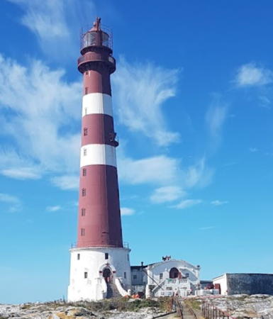
Halten Fyr
Halten Light, Frøya, April 2006
Wikimedia public domain photo by Oddein

Hitra Lighthouses

Hitra is a large island lying in the mouth of the Trondheimsfjord. The island has a population of about 4000 and is readily accessible by the Hitra Tunnel and by ferries. Cruise ships and ferries approaching Trondheim pass through the scenic Trondheimsleia, a strait separating Hitra from the mainland.

West Coast Lighthouses
Sæbuodden
Date unknown. Active; focal plane 16 m (52 ft); white, red or green light depending on direction, 3 s on, 3 s off. 7 m (23 ft) lantern mounted on a platform supported by piles. Lantern painted white with a red roof. No photo available but Bing has an indistinct satellite view. Located on a skerry off the western tip of Hitra, marking the east side of the entrance to the Ramsøyfjord. Accessible only by boat. Site open, tower closed. NF-441400; Admiralty L1378; NGA 7668.
Bussøy (?)
Date unknown. Inactive since 2020; the light may be removed. 8.5 m (28 ft) lantern mounted on a platform supported by piles. Lantern painted white with a red roof. Jøran H. Burø has a 2016 photo and Bing has a distant satellite view. Located on a skerry off the northwestern tip of Hitra. Accessible only by boat. Site open, tower closed. ex-NF-446000; ex-Admiralty L1386; NGA 7696.

Frøyfjord (North Coast) Lighthouses
Værsøydraget
Date unknown. Active; focal plane 6.5 m (21 ft); white, red or green light depending on direction, occulting once every 8 s. 8 m (26 ft) lantern mounted on a platform supported by piles. Lantern painted white with a red roof. No photo available but Bing has a fuzzy satellite view. Located on a skerry in the sound separating Hitra from Værsøy. Accessible only by boat. Site open, tower closed. NF-446500; Admiralty L1388; NGA 7700.
Torsøya (Edoy)
Date unknown. Active; focal plane 6.5 m (21 ft); white, red or green light depending on direction, 3 s on, 3 s off. 4.5 m (15 ft) lantern, white with a red roof. Petr Karban has 2023 photo and Google has a distant satellite view. Located at the east end of a small island on the south side of the Frøyfjord. Accessible only by boat. Site open, tower closed. NF-448700; Admiralty L1408; NGA 7760.
Edøya (Edoy)
Date unknown. Active; focal plane 10.5 m (34 ft); white, red or green light depending on direction, 3 s on, 3 s off. 7 m (23 ft) lantern mounted on a platform supported by piles. Lantern painted white with a red roof. No photo available but Bing has an indistinct satellite view. Located on a small island on the south side of the Frøyfjord, the passage between Hitra and Frøya; narrow white sectors define the channel through this passage. Accessible only by boat. Site open, tower closed. NF-448900; Admiralty L1409; NGA 7752.
Husneset
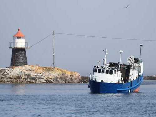
Date unknown. Active; focal plane 6 m (20 ft); white, red or green light depending on direction, occulting three times every 10 s. 6 m (20 ft) lantern mounted on a stone cairn. Lantern painted white with a red roof. Paul Hancock has a photo and Bing has a distant satellite view. Located on a skerry on the east side of the entrance to the harbor of Kjerringvåg, on the north coast of Hitra. Accessible only by boat. Site open, tower closed. NF-449100; Admiralty L1411; NGA 7812.
Ilsøyklubben
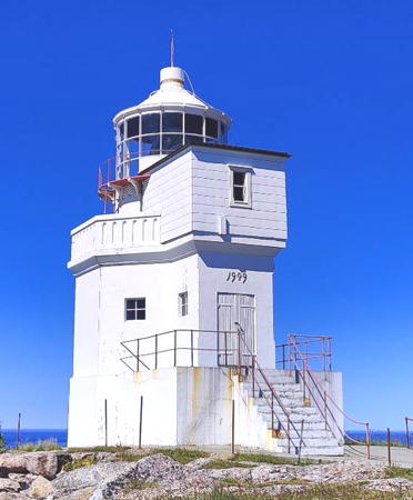
Date unknown. Active; focal plane 8.5 m (28 ft); white, red or green light depending on direction, occulting twice every 8 s. 5 m (17 ft) concrete post with lantern and gallery. Lighthouse painted white, lantern roof red. A stone daybeacon stands near the light. Rainer Schütz's photo is at right and Google has an indistinct satellite view. Located on an island off the northeastern tip of Hitra. Accessible only by boat. Site open, tower closed. NF-445500; Admiralty L1385.6; NGA 7884.
Ilsøyklubben Light
Ilsøyklubben Light, Hitra, March 2001
Flickr photo copyright Rainer Schütz; used by permission

East Coast Lighthouses
Flesa (Kråkvågfjord)
Date unknown. Active; focal plane 14 m (46 ft)); white, red or green light depending on direction, occulting three times every 10 s. 8.5 m (28 ft) rubblestone cairn with lantern and gallery. No photo available but Bing has a satellite view. This light is an important guide for ships approaching Trondheim from the Norwegian Sea. Easily confused with another Flesa in the Frøyfjord (see below). This Flesa is a small island in the Kråkvågfjord northeast of the eastern tip of Hitra and about 2.5 km (1.5 mi) due east of the eastern tip of the island of Fjellværøy. Accessible only by boat. Site status unknown. NF-410600; Admiralty L1192; NGA 7112.
Børøyholmen (2)
1970 (station established 1874). Active; focal plane 13 m (43 ft); white, red or green light depending on direction, occulting once every 6 s. 13 m (43 ft) concrete post with lantern and gallery. Tower painted white; lantern roof is red. Trabas has Boucher's photo and Bing has a satellite view. This light replaced the historic light station, an 8 m (26 ft) tower with gallery attached to a 1-1/2 story keeper's house. The house was demolished in 1973 and only foundations remain; the building was sold and may have been relocated. Located on a small island about 1.2 km (3/4 mi) east of Hestvika, the village at the eastern end of the island of Hitra. Accessible only by boat. Site status unknown. ARLHS NOR-065; NF-409400; Admiralty L1184; NGA 7096.

Trondheimsleia (South Coast) Lighthouses
#Risholmen (1)
Date unknown. Replaced. This was a 6.5 m (24 ft) lantern mounted on a square platform supported by piles. Lantern painted white with a red roof, piles painted black. Trabas has Jim Smith's photo and Bing has a satellite view. The light (focal plane 6 m (20 ft); green light, 1 s on, 1 s off) has been moved to a post. Located on a shoal in the Djupsund, just off the Trondheimsleia, opposite the Hitra airport. Accessible only by boat. Site open, tower closed. ex-NF-408600; ex-Admiralty L1178. Active light: NF-408603; Admiralty L1178.1.
Terningen (2)
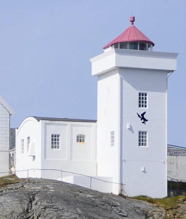
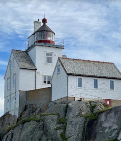
Date unknown (station established 1833). Active; focal plane 18 m (59 ft); white, red or green light depending on direction, occulting once every 6 s. 12 m (39 ft) square cylindrical concrete tower with lantern and gallery. Lighthouse painted white; lantern roof is red. 1-1/2 story keeper's house and other buildings. Michael Clarke's photo is at right, the Lighthouse Association has a page for the lighthouse, Morten Skogly has a photo and a closeup, Trabas has Ronald Wöhrn's photo, Ingo Mathews has a photo, Wikimedia has several photos, and Google has a satellite view of the station. The light guides ships both directions in the Trondheimsleia as well as those leaving the Hemnfjord to the south. The lighthouse is available for overnight accommodations. A friends group, Terningens Venner, helps maintain the light station. Located on a small island about 1 km (0.6 mi) south of the island of Hitra and 1.2 km (3/4 mi) southwest of Jøssenøya. Accessible only by boat. Site and tower closed. Owner: Hitra Kommune. Site manager: Kystmuseet i Sør-Trondelag (Terningen Fyr ). ARLHS NOR-247; NF-407500; Admiralty L1170; NGA 7052.
Værøyan (Værøyene)
Date unknown. Active; focal plane 9 m (30 ft); white, red or green light depending on direction, 3 s on, 3 s off. 9 m (30 ft) concrete post with lantern and gallery. Lighthouse painted white, lantern roof red. Trabas has Siering's photo and Bing has an indistinct satellite view. Located on a skerry off the southwestern tip of Værøy, an island at the southwestern end of Hitra. Accessible only by boat. Site open, tower closed. NF-405200; Admiralty L1162; NGA 7028.
#Grindvikholmen (1)
Date unknown. Replaced in late 2020. This was an 8 m (26 ft) concrete post with lantern and gallery. Lighthouse painted white, lantern roof red. Trabas has Siering's photo and Bing has an indistinct satellite view. This light was replaced by a smaller light showing red, 1 s on, 1 s off; the Admiralty announced this change in January 2021. Located at the extreme southwestern tip of Hitra. Accessible only by boat. Site open, tower closed. ex-NF-405000. Current light: NF-405002; Admiralty L1160; NGA 7032.
Terningen Light
Terningen Light, Hitra, March 2011
Wikimedia Creative Commons photo by Michael Clarke

Frøya Lighthouses

Frøya is an island north of Hitra and also a municipality that includes that island plus an archipelago of islands scattered to the northeast well off the mainland coast. Several major lighthouses are located on these islands. The island of Frøya is accessible from Hitra (and thus from the mainland) by the Frøya Tunnel but the smaller islands require private boat transportation.

Frøya South Coast (Frøyfjord) Lighthouses
Meholmen
Date unknown. Active; focal plane 9 m (30 ft); white, red or green light depending on direction, 3 s on, 3 s off. 6.5 m (21 ft) lantern mounted on a platform supported by piles. Lantern painted white with a red roof. No photo available but Bing has a distant satellite view. Located on a skerry in the southern entrance to the passage between Frøya and Inntian. Accessible only by boat. Site open, tower closed. NF-451600; Admiralty L1422; NGA 7832.
Flesa (Frøyfjord)
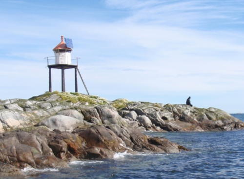
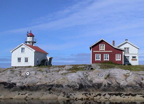
Date unknown. Active; focal plane 8 m (26 ft); white, red or green light depending on direction, occulting twice every 8 s. 6 m (20 ft) lantern mounted on a platform supported by piles. Lantern painted white with a red roof. Jan Erik Havseden has a photo (also seen at right) and Bing has a satellite view. Easily confused with another Flesa in the Kråkvågfjord (see above). Located on a skerry in the eastern entrance to the Frøyfjord, the passage between Frøya and Hitra. Accessible only by boat. Site open, tower closed. NF-451000; Admiralty L1419; NGA 7820.
Frøyfjorden
Date unknown. Active; focal plane 11 m (36 ft); white, red or green light depending on direction, occulting twice every 8 s. 9 m (30 ft) lantern mounted on a platform supported by piles. Lantern painted white with a red roof. No photo available; Google has a very distant street view but the tower is hard to see in Bing's satellite view. Located on a skerry in the central portion of the Frøyfjord. Accessible only by boat. Site open, tower closed. NF-448500; Admiralty L1407; NGA 7740.

Flesa Light, Frøya, July 2010
Google Maps photo by Jan Erik Havseden

Titran Area (Southwest Frøya) Lighthouses
Håvika (Håvik) (2)
Date unknown. Active; focal plane 9 m (30 ft); white, red or green light depending on direction, 3 s on, 3 s off. 8 m (26 ft) octagonal fiberglass tower mounted on a round cylindrical base . Lighthouse painted white with two black horizontal bands and a red roof. Tomasz Jagielsky has a photo and Bing has an indistinct satellite view. The earlier light was in a lantern mounted on a platform supported by piles. Located on a skerry just off the southwest coast of Frøya, about 3 km (2 mi) east of Titran. Accessible only by boat. Site open, tower closed. NF-447700; Admiralty L1402; NGA 7728.
Titran
1900. Active; focal plane 7 m (23 ft); white, red or green light depending on direction, 3 s on, 3 s off. 5 m (16 ft) lantern mounted on a stone base. Lantern painted white with a red roof, base painted black. No photo available but Bing has a distant satellite view. Located on the south side of Sandholmen, an island at the entrance to Titran, at the western tip of the island of Frøya. Accessible only by boat. Site open, tower closed. NF-446900; Admiralty L1394; NGA 7708.
Slettringen (Sletringen, Titran)
1923 (station established 1899). Active; focal plane 46 m (151 ft); two white flashes every 15 s; an additional white passing light (1 s on, 1 s off) is displayed at 31 m (102 ft). 45 m (148 ft) round cast iron tower with lantern and gallery, mounted on a round concrete base and attached to a 2-story keeper's house. Tower painted red with two narrow white horizontal bands; base painted white. 1st order Fresnel lens (1923) in use. Martin Sand's photo is at right, the Lighthouse Association has a page for the lighthouse, K-S Mariusz has a photo, Marinas.com has aerial photos (labeled "Titran"), and Bing has a satellite view of the station. Huelse has a historic postcard view of the original lighthouse as well as a postcard view of the present lighthouse. This is Norway's tallest lighthouse. The Kystverket restored the exterior in 2012 but the interior needs restoration. There are efforts in Frøya to create a friends group. Located on a small island about 1.5 km (1 mi) west of Titran, the village at the western tip of Frøya. Accessible only by boat. Site open, tower closed. . ARLHS NOR-214; NF-446800 (main light) and 446810 (passing light); Admiralty L1392; NGA 7704.
Kvisten (2)
Date unknown. Active; focal plane 17.5 m (58 ft); white, red or green light depending on direction, occulting three times every 10 s. 10 s. 7.5 m (25 ft) round fiberglass tower with lantern and gallery. Lighthouse colored white, lantern roof red. Øyvind Johansen has a 2017 closeup photo, another photo is available, and Bing has a distant satellite view. The first light was a square tower with lantern and gallery. Located on a rocky bluff on the north side of the southwestern peninsula of Frøya. Site status unknown. NF-458000; Admiralty L1452; NGA 7920.
Gulholmen
Date unknown. Active; focal plane 7.5 m (25 ft); white, red or green light depending on direction, occulting twice every 8 s. 6 m (20 ft) lantern mounted on a platform supported by piles. Lantern painted white with a red roof. No photo available but Google has a distant satellite view. This light was dropped from the current edition of the Norsk Fyrliste. Located on a skerry in the entrance to Nordskaget, a sheltered harbor on the north side of the southwestern peninsula of Frøya. Accessible only by boat. Site open, tower closed. NF-458100; Admiralty L1454; NGA 7924.

Sletringen Light, Frøya, August 2021
Google Maps photo by Martin Sand
Urdviksholmen (Orsvikholmen)
Date unknown. Active; focal plane 6.5 m (21 ft); white, red or green light depending on direction, occulting three times every 12 s. 6.5 m (21 ft) lantern mounted on a platform supported by piles. Lantern painted white with a red roof. No photo available but Bing has a distant satellite view. Located on a skerry about 2 km (1.2 mi) southwest of Sandvika on the west coast of Frøya. Accessible only by boat. Site open, tower closed. NF-458800; Admiralty L1462; NGA 7948.
Humlingsværet (Homlingsvaer)
Date unknown. Active; focal plane 7 m (23 ft); white, red or green light depending on direction, occulting twice every 8 s. 6.5 m (21 ft) square tower with lantern and gallery. Lighthouse painted white, lantern roof red. No photo available but Bing has a distant satellite view. Located on a small island, the largest of a group of islands and skerries off the west side of Frøya. Accessible only by boat. Site open, tower closed. NF-459500; Admiralty L1466; NGA 7952.

Kya Lighthouses
Sydkya (Sunnkya, Synnkya)
Date unknown. Active; focal plane 8 m (26 ft); flash every 5 s, white, red or green depending on direction. 8.5 m (28 ft) lantern mounted on a platform supported by piles. Lantern painted white with a red roof. No photo available but Bing has a distant satellite view. Located on a skerry about 1.4 km (0.9 mi) south of the Kya lighthouse. Accessible only by boat. Site open, tower closed. NF-459800; Admiralty L1468; NGA 7956.
Litlleiskjæret (Lilleleiskjaer)
Date unknown. Active; focal plane 7 m (23 ft); white, red or green light depending on direction, occulting three times every 12 s. 8 m (26 ft) lantern mounted on a platform supported by piles. Lantern painted white with a red roof. No photo available but Bing has a distant satellite view. Located on a skerry about 0.8 km (1/2 mi) southeast of the Kya lighthouse. Accessible only by boat. Site open, tower closed. NF-460000; Admiralty L1470; NGA 7960.
Kya (2)
1920 (station established 1906). Active; focal plane 14 m (46 ft); white, red or green light depending on direction, 3 s on, 3 s off. 12 m (39 ft) square skeletal tower with lantern, gallery, and enclosed watch room. Lighthouse painted white; lantern room painted red. Several 1-1/2 story cottages, part of a fishing camp; one may be a former keeper's house. Roger Husvik's photo is at right, another photo is available, Inger Elisabeth Pettersen has a 2022 view, and Bing has a satellite view of the station. Confusingly, this light has the same name as a major lighthouse described on the Trondheim Area page. Located on a small island about 4 km (2.5 mi) north of the western tip of Frøya. Accessible only by boat. Site open, tower closed. NF-460200; Admiralty L1472; NGA 7964.
Kya Light
Kya Light, Frøya, July 2005
ex-Panoramio Creative Commons photo by Roger Husvik

Frøya North Coast Lighthouses
Sulsleikua
Date unknown. Active; focal plane 11 m (36 ft); white, red or green light depending on direction, 3 s on, 3 s off. 8 m (26 ft) rubblestone tower with lantern and gallery. Tower painted with black and white horizontal bands, lantern painted white with a red roof. No photo available but Bing has a distant satellite view. Located on a skerry off the north side of Frøya, about 4 km (2.5 mi) west northwest of Breivika. Accessible only by boat. Site open, tower closed. NF-462400; Admiralty L1492; NGA 7988.
Lyngøyholmen
Date unknown. Active; focal plane 5.5 m (18 ft); white, red or green light depending on direction, occulting three times every 12 s. 6.5 m (21 ft) lantern mounted on a platform supported by piles. Lantern painted white with a red roof. No photo available but Bing has a distant satellite view. Located on a small island off the north coast of Frøya, about 2.5 km (1.5 mi) north of Garnvika. Accessible only by boat. Site open, tower closed. NF-461800; Admiralty L1490; NGA 8016.

Sula Lighthouses
Sula is a small island in the Norwegian Sea about 15 km (9 mi) northwest of Frøya. The fishing village on the island has a population of about 100. The island is accessible by ferry from Setra on the north side of Frøya or from Mausand.
Håskjæret
Date unknown. Active; focal plane 7 m (23 ft); white, red or green light depending on direction, 3 s on, 3 s off. 6 m (20 ft) concrete post with lantern and gallery. Lighthouse painted white, lantern roof red. No photo available but Bing has a distant satellite view. Located on a skerry about 4 km (2.5 mi) southeast of the Sula lighthouse. Accessible only by boat. Site open, tower closed. NF-464800; Admiralty L1503; NGA 8000.
* Sula (3)
1909 (daybeacon established 1793). Active; focal plane 43 m (141 ft); three white flashes every 30 s. 13 m (43 ft) octagonal concrete tower with lantern and gallery. Entire lighthouse painted white. Original 2nd order Fresnel lens in use. Keeper's house, shop, boathouse and other light station buildings. A photo is at right, the Lighthouse Association has a page for the lighthouse, Torgrim Johansen has another good 2007 photo, Marinas.com has aerial photos, Google has a street view, and Bing has a satellite view. This station is an important landfall light for the Trondheim area. The first beacon was replaced in 1804, but neither of these early beacons carried a light. In 2005 the light station was purchased by a foundation. A restoration was carried out in 2015. Accommodations in the keeper's house are available. Located on the highest point of the island of Sula. Owner/site manager: Stiftelsen Sula Fyr . Site open, tower closed. ARLHS NOR-043; NF-465000; Admiralty L1504; NGA 8032.
Kalholmen
Date unknown. Inactive since 2022. 10 m (33 ft) square skeletal tower, the upper portion enclosed by siding, with lantern and gallery. Lighthouse painted white, lantern roof red. No photo available but Bing has an indistinct satellite view. Located at the north point of Kalholmen, an island about 1.8 km (1.1 mi) west of Sula. Accessible only by boat. Site open, tower closed. ex-NF-465400; ex-Admiralty L1508; NGA 8044.

Mausund Lighthouses
Mausund is a village on a group of islands north of Frøya and east of Sula. The village is accessible by ferry from Setra, on the north side of Frøya.

Måøya (Mauøy)
1900. Inactive since 2022. Approx. 7 m (23 ft) square pyramidal stone tower originally with lantern and gallery. Lantern painted white with a red roof. No photo available but Google has a satellite view. Located on the southern point of Mauøy, the southernmost inhabited island in the Mausund group, about 400 m (1/4 mi) east of Kåvik. Site status unknown, but probably open. ex-NF-463200; ex-Admiralty L1496; NGA 8012.

Sula Light, Frøya, July 2022
Instagram photo by Spapir
Landbøtskjær
Date unknown. Active; focal plane 5 m (17 ft); white, red or green light depending on direction, occulting twice every 8 s. 5.5 m (18 ft) lantern mounted on a platform supported by piles. Lantern painted white with a red roof. No photo available but Bing has a distant satellite view. Located on a skerry about 800 m (1/2 mi) north of Mausund. Accessible only by boat. Site open, tower closed. NF-467700; Admiralty L1522; NGA 8092.
Vingleia (1)
1921. Inactive since 1985. 19 m (62 ft) square cylindrical wood tower rising from a 2-1/2 story wood keeper's house. Lighthouse painted white, lantern red. A photo is at right, Riccardo Borghi has a sunset photo, Riccardo Borghi has a view from the sea, and Bing has a satellite view. The Lighthouse Association has a page for the lighthouse. The lighthouse has been renovated and is available for overnight and vacation accommodations. In November 2021 the Norwegian Fishermen's Association (Norges Fiskarlag) recognized the restoration with the Coastal Culture Award (Kystkulturprisen) for 2021. Located on a small island in the Norwegian Sea about 4 km (2.5 mi) north of Mausund. Accessible only by boat. Site open, tower closed. Site manager: Vingleia Fyrs Venner . ARLHS NOR-278.
Vingleia (2)
1985. Active; focal plane 14 m (46 ft); white, red or green light depending on direction, occulting twice every 8 s. Approx. 7 m (23 ft) round cylindrical tower with lantern and gallery. Lighthouse painted white with one narrow black horizontal band; lantern roof painted red. A photo is at right. Located adjacent to the historic lighthouse. Site open, tower closed. ARLHS NOR-423; NF-467300; Admiralty L1520; NGA 8088.
Østre Skotskjær
Date unknown. Active; focal plane 11 m (36 ft); flash every 5 s, white, red or green depending on direction. 9.5 m (31 ft) concrete post with lantern and gallery. Lighthouse painted white; lantern roof painted red. No photo available but Bing has a satellite view. Located on a skerry about 8 km (5 mi) northeast of Mausund. Accessible only by boat. Site open, tower closed. NF-468000; Admiralty L1526; NGA 8104.
Gjæsingen (Gjesingen)
Date unknown. Active; focal plane 8 m (26 ft); white, red or green light depending on direction, occulting twice every 8 s. 5 m (17 ft) lantern and gallery mounted on a base of unknown type. Lighthouse painted white; lantern roof painted red. The lighthouse appears in the center of a distant view of the town and Bing has a distant satellite view. Gjæsingen is a populated island about 12 km (7.5 mi) east northeast of Mausund. Located at the southern tip of the island. Accessible only by boat. Site open, tower closed. NF-468500; Admiralty L1528; NGA 8120.
Gjæsingbogen
Date unknown. Active; focal plane 8 m (26 ft); flash every 5 s, white, red or green depending on direction. 7.5 m (26 ft) concrete post with lantern and gallery. Lighthouse painted white; lantern roof painted red. No photo available but Bing has a satellite view. Located on a skerry about 2.5 km (1.5 mi) east of Gjæsingen. Accessible only by boat. Site open, tower closed. NF-468800; Admiralty L1529; NGA 8116.

Vingleia Light, Frøya, November 2022
Instagram photo by royjossund

Froan Area Lighthouses
Bleika
Date unknown. Active; focal plane 14 m (46 ft); white, red or green light depending on direction, occulting twice every 8 s. 8 m (26 ft) cocrete post with lantern and gallery. Lighthouse painted white, lantern roof red. No photo available but Bing has a satellite view. Located on a small island about 6 km (3.5 mi) south of the Finnvær light station (next entry). Accessible only by boat. Site open, tower closed. NF-470500; Admiralty L1542; NGA 8156.
Finnvær (1)
1912. Inactive since 1985. Approx. 15 m (49 ft) square cylindrical wood tower rising from a 2-1/2 story wood keeper's house. Lighthouse painted white, lantern red. Kåre Inge Skarsvåg's photo is at right, Callum Sinclair has a photo, the Lighthouse Association has a page for the lighthouse, and Bing has a satellite view of the station. Located on a small island in the Norwegian Sea about 27 km (16 mi) northeast of Mausund. Accessible only by boat. Site open, tower closed. ARLHS NOR-080.
Finnvær (2)
1985. Active; focal plane 18 m (56 ft); white, red or green light depending on direction, 2 s on, 2 s off. 10 m (33 ft) round cylindrical tower with lantern and gallery. Lighthouse painted with black and white horizontal bands; lantern roof painted red. Callum Sinclair has a photo. Located adjacent to the historic lighthouse. Site open, tower closed. . ARLHS NOR-416; NF-471000; Admiralty L1544; NGA 8160.
Kristianskjæra (Kristianskjaerene)
Date unknown. Active; focal plane 9 m (30 ft); white, red or green light depending on direction, 3 s on, 3 s off. 9 m (30 ft) concrete post with lantern and gallery. Lighthouse painted white; lantern roof painted red. No photo available and Bing has only a fuzzy satellite view of the skerry. Located on a skerry in the northern portion of the Froan island group. Accessible only by boat. Site open, tower closed. NF-471200; Admiralty L1546; NGA 8164.

Halten Lighthouses
Keilskjæret
Date unknown. Active; focal plane 8.5 m (28 ft); white, red or green light depending on direction, occulting three times every 12 s. 5.5 m (18 ft) concrete post with lantern and gallery. Lighthouse painted white; lantern roof painted red. No photo available but clouds block Google's satellite view. Located on a skerry about 5.5 km (3.5 mi) southwest of the Halten lighthouse. Accessible only by boat. Site open, tower closed. NF-471400; Admiralty L1547; NGA 8172.

Finnvær Lights, Frøya, August 2022
Google Maps photo by Kåre Inge Skarsvåg
Halten
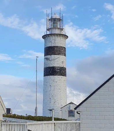
1875 (originally built at Lista in 1853). Active; focal plane 39 m (128 ft); white flash every 4 s. 30 m (98 ft) stone tower with lantern and gallery. Lighthouse painted white with two narrow black horizontal bands. Two 1-1/2 story keeper's houses, boathouse, and other station buildings. A photo is at the top of this page, a fine closeup is available, and Odd Ragnar Mikalsen has a closeup 2021 photo of the lighthouse in action, but clouds block Google's satellite view. This was originally one of the twin lighthouses built at Lista, near Vestbygda in the former Vest-Agder county. It was dismantled in 1874 and rebuilt here the following year. The lighthouse remains in good condition since it was staffed as late as 2004. The former fishing village of Halten was evacuated after a destructive fire in 1963 and the island is now managed by a foundation, Stiftelsen Halten. The foundation organizes tours of the lighthouse and is working to make accommodations available in the keeper's quarters. Located on an island in the Norwegian Sea about 40 km (25 mi) northeast of Mausund. Accessible only by boat in heavy seas. Site open, tower closed. Site manager: Stiftelsen Halten (Halten Fyr). . ARLHS NOR-106; NF-471800; Admiralty L1550; NGA 8176.
Skanken
Date unknown. Active; focal plane 8 m (26 ft); white, red or green light depending on direction, 2 s on, 2 s off. 8.5 m (28 ft) square pyramidal wood-shingled tower with lantern and gallery. Lighthouse painted white, lantern roof red. Tone Skjørholm has a photo, Bente Kristin Schjolberg has a photo of this light and the Halten lighthouse, and Aslak Raanes has a distant view, but clouds block Google's satellite view. Located across the harbor from the Halten lighthouse. Site open, tower closed. NF-472000; Admiralty L1552; NGA 8180.

Information available on lost lighthouses:

Notable faux lighthouses:

Adjoining pages: East: Trondheim Area | South: Kristiansund Area

Return to the Lighthouse Directory index | Ratings key

Posted August 3, 2006. Checked and revised June 22, 2023. Lighthouses: 44. Site copyright 2023 Russ Rowlett and the University of North Carolina at Chapel Hill.