Lighthouses of Norway: Nordfjord

The Kingdom of Norway (Norge in Norwegian) is one of the world's most maritime nations. The country is long and narrow, with drowned valleys called fjords that bring the sea far inland in most regions. The mainland coast is estimated to be 2650 km (1650 mi) long and when all the islands and minor indentations are counted the total coastline approaches an astonishing 60,000 km (37,500 mi), long enough the go around the world one and a half times. With such a lengthy and rocky shore it's not surprising that Norway has a large number of lighthouses.

Norway is divided into counties (fylker) and the counties are divided into municipalities (kommuner). This page lists lighthouses of the Nordfjord district in the former county of Sogn og Fjordane. Located north of Bergen and south of Trondheim, Sogn og Fjordane has no large population centers. It is a county of steep mountains and deep fjords with some of the most spectacular scenery Norway has to offer. The Nordfjord district is centered on the fjord of the same name, which extends 106 km (66 mi) into the mountains.

On 1 January 2020 Hordaland County and most of Sogn og Fjordane County were merged to form the new Vestland County.

In Norwegian a lighthouse is a fyrtårn (fire tower) or simply a fyr; a fyrlykt is a beacon and a lyktehus is a lantern. Øy is an island, holmen is an islet, skjær is a skerry (a tiny island or rocky reef), sund is a strait (often between an island and the mainland), bukt is a bay, nes is a headland, and havn is a harbor.

Aids to navigation in Norway are maintained by the Kystverket (Coast Directorate), an agency of the Ministry of Transport and Communications.

ARLHS numbers are from the ARLHS World List of Lights. NF numbers are from the Norsk Fyrliste. Admiralty numbers are from volume L of the Admiralty List of Lights & Fog Signals. U.S. NGA List numbers are from Publication 115.

General Sources
Online List of Lights - Norway
Photos by various photographers posted by Alexander Trabas. Many of the photos for this area are by Michael Boucher or Arno Siering.
Norwegian Lighthouse Association
News and photos from the Association.
Lighthouse Pages from Anke and Jens - Norway
Excellent photos of more than 60 Norwegian lighthouses.
Norway's Fjorden and Lighthouses
Photos taken by Charles W. Bash on a 2010 cruise from Bergen to North Cape.
Leuchttürme in Norwegen
Photos posted by Andreas Köhler.
Lighthouses in Vestland
Photos by various photographers available from Wikimedia.
Norwegische Leuchttürme auf historischen Postkarten
Historic postcard images posted by Klaus Huelse.
Liste over Norske Fyr
From Norwegian Wikipedia, a handy list of Norwegian light stations with their dates of establishment.
Norsk Fyrliste
The official Norwegian light list can be downloaded in six .pdf volumes.
Navionics Charts
Navigation chart for the Norwegian coast.

Kråkenes Fyr
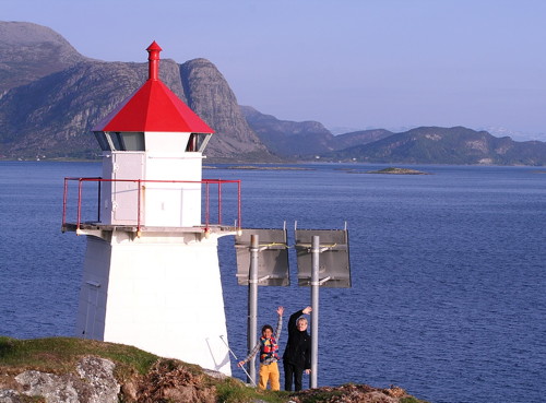
Kråkenes Light, Vågsøy, July 2007
Wikimedia Creative Commons photo by Chell Hill

Bremanger Lighthouses
Sør Botnen (Botnane)
1897. Active; focal plane 4 m (13 ft); white, red or green light, depending on direction, occulting once every 6 s. 4 m (13 ft) octagonal lantern mounted on a round rubblestone base. Lantern painted white with a red roof. Trabas has Siering's photo and Google has a 2010 street view and a distant satellite view. Located on a point of land marking the south side of the entrance to the Frøysjøen sound, about 8 km (5 mi) north northwest of Florø. Site open, tower closed. NF-267500; Admiralty L0356; NGA 5276.
* Smørhavn (Smørhamn, Fiskholmen) (2)
1936 (?) (station established 1871). Active; focal plane 26 m (86 ft); white, red or green light, depending on direction, 3 s on, 3 s off. 7 m (23 ft) square skeletal tower, covered with white siding, with octagonal lantern and gallery. Lighthouse painted white; lantern roof is red. A photo is at right, Trabas has Siering's photo and Bing has a satellite view. Foundation ruins near the tower are the remains of the original lighthouse; Wikipedia has a historic photo. Located on a skerry off the southwestern point of the large island of Bremangerlandet, marking the north side of the entrance to the Frøysjøen sound. Accessible by road from Bremanger. Site open, tower closed. ARLHS NOR-217; NF-269300; Admiralty L0386; ex-NGA 5308.
* Kalvåg
1904. Active; focal plane 7 m (23 ft); white, red or green light, depending on direction, occulting once every 6 s. 4 m (13 ft) octagonal lantern mounted on a concrete pad. Lantern painted white with a red roof. A good photo (first photo on the page) is available and Google has a street view and a distant satellite view. This light guides ships approaching Kalvåg from the mainland. Located on the southeast side of the island of Frøya, about 500 m (0.3 mi) east of the Kalvåg waterfront. Site open, tower closed. NF-269800; Admiralty L0378.2; ex-NGA 5320.
Sparkeltaren (2)
2008 (station established 1931). Active; focal plane 6 m (20 ft); white, red or green light, depending on direction, occulting twice every 8 s. 11 m (36 ft) lantern supported by tripod piles. Trabas has Siering's photo, two photos (second and third photos on the page) are available, and Google has a distant satellite view. Located in the Oldersund about 700 m (0.4 mi) off the Kalvåg waterfront. Accessible only by boat. Site open, tower closed. NF-270000; Admiralty L0384; ex-NGA 5324.
Fiskholmen Fyr
Smørhavn (Fiskholmen) Light, Bremanger
Kalvåg Tourist Development Center photo (no longer online)
* [Sparkeltaren (1) (lantern)]
1931. Inactive (?). Octagonal lantern, painted white with a red roof. The lantern has been relocated to the north end of the Amtskaia wharf in Kalvåg harbor. Daianne Dahl has a photo and Google has a distant satellite view. Site open, tower closed.
Olaskjær
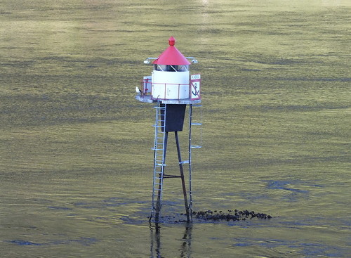
Date unknown. Active; focal plane 10.5 m (34 ft); white, red or green light, depending on direction, 2 s on, 2 s off. 10 m (33 ft) lantern mounted on a platform supported by four piles. Lantern is white with a red roof, piles painted black. Trabas has Siering's photo (also seen at right) and Google has an indistinct satellite view. Located on a reef in the middle of the entrance to the Frøysjøen. Accessible only by boat. Site open, tower closed. NF-266500; Admiralty L0354; NGA 5272.
* Nesje (4?)
2005 (station established 1894). Active; focal plane 24 m (79 ft); white, red or green light, depending on direction, occulting once every 6 s. 7.5 m (25 ft) round fiberglass tower with a round lantern and gallery. Lighthouse is white; lantern roof is red. Monica Lundekvam Sundal has a photo, a closeup is available, Ole Ohrvik has a closeup 2022 street view, and Google has a distant satellite view. Located on the northernmost point of Frøya, about 4 km (2.5 mi) northwest of Kalvåg. Site open, tower closed. NF-271500; Admiralty L0400; NGA 5348.
Oldesteinen (3)
1949 (station established 1931). Active; focal plane 5.5 m (18 ft); white, red or green light, depending on direction, 2 s on, 2 s off. 12 m (39 ft) lantern and gallery mounted on tripod piles. Lantern painted white with red roof, piles painted black. No photo available but Bing has a distant satellite view. Located off the east side of Frøya, marking the northern entrance to the Oldersund. Accessible only by boat. Site open, tower closed. NF-271000; Admiralty L0398; ex-NGA 5344.

Olaskjær Light, Bremanger, July 2012
photo copyright Arno Siering; used by permission
Iglandsvika (Iglandsvik)
Date unknown. Active; focal plane 5.5 m (18 ft); white, red or green light, occulting twice every 8 s. 11 m (36 ft) lantern mounted on a platform supported by tripod piles. Lantern painted white with a red roof, piles painted black. Lightphotos.net has Andreas Köhler's closeup photo, a small aerial photo of the port (bottom of the page) shows the light, and Google has a distant satellite view and a very distant street view. Located just off the end of the pier at Iglandsvik, a small port on the west side of Bremangerlandet. Accessible only by boat, but easy to see from shore. Site open, tower closed. NF-272000; Admiralty L0410; NGA 5368.
Øksneset
1936. Active; focal plane 87.5 m (287 ft); two flashes every 10 s, white, red or green, depending on direction. 4 m (13 ft) lantern on a concrete base. Lantern painted white with a red roof. No photo available but Google has a distant satellite view. Located on a steep promontory on the west side of the island of Bremangerlandet. Site status unknown. NF-274000; Admiralty L0414; NGA 5384.
Skaten
1912. Active; focal plane 7 m (23 ft); white, red or green light, depending on direction, occulting twice every 8 s. 7 m (23 ft) lantern mounted on tripod piles. Lantern painted white with a red roof, piles painted black. Lightphotos.net has Arno Siering's photo, Trabas has the same photo, and Bing has an indistinct satellite view. Located on the south side of the Skatestraumen, the channel separating the islands of Bremangerlandet and Rugsundsøy, about 5 km (3 mi) southeast of Vågsøy; the Skatestraumen Tunnel passes almost directly under the light. Accessible only by boat. Site open, tower closed. NF-277400; Admiralty L0430; ex-NGA 5416.
Ospenes
Date unknown. Active; focal plane 5.5 m (18 ft); white, red or green light, depending on direction, 2 s on, 2 s off. 4 m (13 ft) lantern on a stone base. Trabas has Siering's photo and Bing has a satellite view. Located on the north side of the entrance to the 3-branched fjord known as Gulen. Site status unknown (probably on private property). NF-268000; Admiralty L0360; ex-NGA 5288.

Gloppen Lighthouse
* Anden (Anda)
Date unknown. Active; focal plane 5 m (16 ft); white, red or green light, depending on direction, occulting once every 6 s. 6 m (20 ft) octagonal lantern and gallery mounted on four piles. Lantern painted white with a red roof, piles painted black. Trabas has Rainer Arndt's photo, Andreas Köhler has a 2019 photo, Jan Petter Hansen has a lovely 2021 view, and Google has a satellite view. Located on the west side of the entrance to the Gloppefjord from the Nordfjord, near the terminal for the ferry carrying the E39 highway across the Nordfjord at Lote. Site open, tower closed. NF-280400; Admiralty L0462; ex-NGA 5468.

Skaten Light, Bremanger, July 2012
Lightphotos.net photo copyright Arno Siering; used by permission

Stryn Lighthouse
* Rakenes
Date unknown. Active; focal plane 5.5 m (18 ft); white, red or green light, depending on direction, occulting once every 6 s. 6 m (20 ft) square skeletal tower, covered with white siding, with octagonal lantern and gallery. Lighthouse painted white; lantern roof is red. Trabas has Rainer Arndt's photo and Google has a satellite view. Located on the north side of the Innvikfjord, a branch of the upper Nordfjord. Accessible from highway 60 about 13 km (8 mi) southeast of Stryn. Site open, tower closed. NF-280600; Admiralty L0466; ex-NGA 5472.

Stad: Eid Lighthouses
On 1 January 2020 the former townships of Eid and Selje were merged to form Stad Township.

* [Reksnes]
1915. Active; focal plane 5 m (17 ft); white, red or green light, depending on direction, occulting once every 6 s. 3 m (10 ft) lantern. Lighthouse painted white; lantern roof painted red. No photo available but Google has a satellite view. Located on a promontory on the north side of the Nordfjord at Reksnes, about 40 km (25 mi) east of Vågsøy. Site open, tower closed. NF-279400; Admiralty L0448; ex-NGA 5448.

Kinn: Vågsøy Lighthouses
On 1 January 2020 the Flora Township was joined with Vågsøy to form the Kinn Township. The new township is discontinuous; lighthouses of Flora are described on the Sunnfjord page.
Gangsøy
Date unknown. Active; focal plane 5 m (17 ft); white, red or green light, depending on direction, occulting twice every 8 s. 6.5 m (21 ft) lantern mounted on a platform supported by four piles. Lantern painted white with a red roof, piles painted black. Trabas has Arno Siering's photo and Bing has a satellite view. Located on the northeastern point of Gangsøy, an island in the Skatestraumen passage between Bremangerlandet and Vågsøy. NF-277800; Admiralty L0424; ex-NGA 5424.
* Hendanes
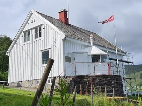
1914. Active; focal plane 48 m (157 ft); white, red or green light, depending on direction, occulting twice every 8 s. Approx. 6 m (20 ft) octagonal cylindrical wood tower with lantern and gallery, adjacent to a wood keeper's house. Tower painted white, lantern red. A photo by S. Schmidt is at right, the Lighthouse Association has a page for the lighthouse, the Anke/Jens site also has a page, Siv-Grethe Breiteig has a 2021 closeup, Wikimedia has a distant view, and Google has a deeply shadowed satellite view. Probably endangered; according to Ragnar Myre the keeper's house is in poor condition. The Kystverket and Kinn Kommune are discussing possible uses for the building. Located on a promontory at the entrance to the Kvalheimsvika, about 3 km (2 mi) northwest of Vågsvåg on the island of Vågsøy. Accessible by a walk of about 800 m (1/2 mi) from the end of the road off highway 601 north of Vågsvåg. Site open, and it there is access to the gallery by an external ladder. . ARLHS NOR-116; NF-284000; Admiralty L0472; NGA 5496.
#Nord-Vågsøy
Date unknown. Inactive since 2014 and apparently removed. This was a 6 m (20 ft) square tower with lantern and gallery. Lighthouse painted white, lantern roof red. No photo available and the light is not seen in Google's satellite view. Formerly located high on a cliff on the northwest coast of Vågsøy. Site status unknown; it would not be easy to reach this location. ex-NF-284500; ex-Admiralty L0506; ex-NGA 5572.
* Kråkenes (2)
1950 (station established 1906). Active; focal plane 45 m (148 ft); white, red or green light, depending on direction, occulting once every 6 s. 10 m (33 ft) lantern and gallery on the seaward side of a 2-1/2 story wood keeper's house. Lighthouse painted white; the lantern (at least the roof) is painted red. Chell Hill's photo is at the top of this page, Anke and Jens have a page with excellent photos, Axel Hydre has a good photo, Ragnar Myre has a portfolio of photos, Trabas has a photo, and Google has a street view and a satellite view. The original lighthouse was destroyed by fire following a Allied air raid in 1945. Automated in 1994, the current lighthouse now houses a restaurant and has rooms available for overnight accommodations. Located at the northwestern point of the island of Vagsøy, on a spectacular knifelike promontory. Accessible by road. Site open, lighthouse open to paying guests. Site manager: Kråkenes Fyr . ARLHS NOR-141; NF-290500; Admiralty L0504; NGA 5556.

Hendanes Light, Vågsøy, February 2019
Google Maps photo by S. Schmidt
Skongenes
1870. Active; focal plane 16 m (52 ft); white, red or green light, depending on direction, occulting twice every 8 s. 10 m (33 ft) square wood tower with lantern and gallery. Lighthouse painted white, lantern and gallery red. 1-1/2 story wood keeper's house and other light station buildings preserved. A photo is at right, Trabas has Ronald Wöhrn's photo, Nils Erik Bjørkedal has a 2019 photo, Ragnar Myre has posted additional photos, Anke and Jens have a panoramic view, Bash has a distant view, and Google has a satellite view. The keeper's house is available for overnight accommodations. Ytre Nordfjord Turlag provides transportation and offers guided tours to this light station. Accessible by a one hour hike from Halsør. Located on the northern tip of the island of Vagsøy. Site open, tower closed. Site manager: Skongenes Fyr . ARLHS NOR-209; NF-290000; Admiralty L0508; NGA 5552.
* Silda Hamn
Date unknown. Active; focal plane 5 m (17 ft); white, red or green light, depending on direction, 2 s on, 2 s off. 6 m (20 ft) lantern mounted on four straightpiles. Lantern painted white with a red roof, piles painted black. Frode Tennebø has a distant view and Google has a satellite view. Silda is a small island in the sound called the Sildegapet, northeast of the island of Vågsøy. A small village on the island is accessible by ferry from Vågsøy. Located at the end of the north breakwater of Silda. Accessible by walking the mole. Site open, tower closed. NF-291000; Admiralty L0510; ex-NGA 5560.
Ulven
Date unknown. Active; focal plane 7.5 m (25 ft); white, red or green light, depending on direction, occulting once every 6 s. 9 m (30 ft) lantern and gallery supported by tripod piles. Lantern painted white with a red roof, piles painted black. Trabas has Boucher's photo and Google has a distant satellite view. Located in the Ulvesund, the protected passage east of Vågsøy, halfway between Maløy and Raudeberg. Accessible only by boat. Site open, tower closed. NF-288000; Admiralty L0494; ex-NGA 5528.

Skongenes Light, Vågsøy
photo posted by Norwegian Lighthouse Association
* Ulvesund (Hjertneset Range Front) (2)
1985 (station established 1870). Active; focal plane 13 m (43 ft); white, red or green light, depending on direction, occulting three times every 10 s. 10 m (33 ft) slender round cylindrical concrete tower with lantern and gallery. Lighthouse painted white; lantern roof is red. Trabas has Boucher's photo, another photo is available, Anke and Jens also have a photo, Lightphotos.net has a photo, and Google has a street view and a satellite view. Located on the east side of the entrance to Ulvesund, about 8 km (5 mi) north of Vågsøy. Accessible by road. Site open, tower closed. ARLHS NOR-260; NF-289000; Admiralty L0498; ex-NGA 5540.
*** Ulvesund (1)
1870. Inactive since 1985. Lantern attached to the front of a 1-1/2 story keeper's house. Lighthouse painted white with a red vertical stripe on the lantern and another on the end of the house. Michael Boucher's photo is at right, Anke and Jens have a page for the lighthouse, Lightphotos.net has Andreas Köhler's closeup photo, and Google has a street view and a satellite view. In 2003 the light station was leased to a provate operator; the lighthouse is now a café and another light station building is available for overnight stays. Located on the east side of the entrance to Ulvesund, about 8 km (5 mi) north of Vågsøy. Accessible by road. Site open, café open daily mid June to mid August, tower closed. Owner/site manager: Ulvesund Fyr .
* [Ulvesund Range Rear]
Date unknown. Active; focal plane 39 m (128 ft); red light occulting once every 6 s. 2 m (7 ft) hexagonal lantern; the front face is painted red and the rest white. Lightphotos.net has Andreas Köhler's closeup photo, Trabas has Boucher's photo, Anke and Jens have two excellent photos, and Bing has a satellite view. Located 90 m (100 yd) uphill behind the Ulvesund lighthouse. Site open, tower closed. ARLHS NOR-403; NF-289100; Admiralty L0498.1; ex-NGA 5544.
Ulvesund Fyr
Ulvesund (Hjertneset) Light, Vågsøy, September 2011
photo copyright Michael Boucher; used by permission
Skavøypollen
Date unknown. Active; focal plane 5.5 m (18 ft); white, red or green light, depending on direction, occulting three times every 10 s. 4 m (13 ft) lantern and snow shield. Lighthouse is white, lantern roof red. Jakub Sromek has a 2019 photo and Google has a distant satellite view. Located near the Steinvik campground, about 5 km (3 mi) southeast of Måløy on the south coast of Vågsøy. Site status unknown. NF-285500; Admiralty L0482; ex-NGA 5500.

Stad: Selje Lighthouses
On 1 January 2020 the former townships of Eid and Selje were merged to form Stad Township.
Saltnes
Date unknown. Active; focal plane 8 m (26 ft); white, red or green light, depending on direction, occulting twice every 8 s. 7.5 m (25 ft) square skeletal tower, covered with siding, with lantern and gallery. Lighthouse painted white, lantern roof red. Google has a satellite view. Located on the south side of the entrance to the Moldefjord, opposite the town of Selje. Probably accessible only by boat. Site open, tower closed. NF-291300; Admiralty L0514; NGA 5564.
Buholmen (2)
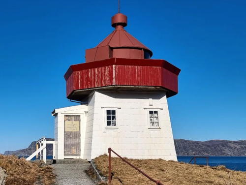
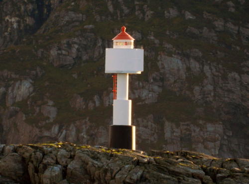
Date unknown. Active; focal plane 31 m (101 ft); flash every 5 s, white, red or green depending on direction. 10 m (33 ft) fiberglass post with lantern and gallery. Lighthouse painted white, lantern roof red. Trabas has Boucher's photo (also seen at right), Eduard Munt has a view from the sea, Bash has a distant photo, and Google has a distant satellite view. Buholmen is a prominent cape at the end of a long peninsula about 20 km (13 mi) northwest of Selje, at the extreme northwest corner of Sogn og Fjordane. Located on a skerry off the tip of the cape. Practically inaccessible in heavy seas, but there's a good view from the tip of the cape, which is apparently accessible by hiking trail. Site and tower closed. NF-294000; Admiralty L0520; NGA 5576.
Honningsvåg
Date unknown. Active; focal plane 16.5 m (54 ft); white, red or green light, depending on direction, occulting once every 6 s. 6 m (20 ft) square skeletal tower, covered with siding, with lantern and gallery. Lighthouse painted white, lantern roof red. Trabas has Siering's photo and Google has a street view and a distant satellite view. Located on the north side of the entrance to a protected cove about 2.5 km (1.5 mi) south of Buholmen. Site status unknown. NF-295000; Admiralty L0526; NGA 5584.

Buholmen Light, Selje
photo copyright Michael Boucher; used by permission

Information available on lost lighthouses:

Notable faux lighthouses:

Adjoining pages: North: Ålesund Area | South: Sunnfjord

Return to the Lighthouse Directory index | Ratings key

Posted June 19, 2006. Checked and revised May 24, 2023. Lighthouses: 27. Site copyright 2023 Russ Rowlett and the University of North Carolina at Chapel Hill.