Lighthouses of Norway: Romsdal (Molde Area)

The Kingdom of Norway (Norge in Norwegian) is one of the world's most maritime nations. The country is long and narrow, with drowned valleys called fjords that bring the sea far inland in most regions. The mainland coast is estimated to be 2650 km (1650 mi) long and when all the islands and minor indentations are counted the total coastline approaches an astonishing 60,000 km (37,500 mi), long enough the go around the world one and a half times. With such a lengthy and rocky shore it's not surprising that Norway has a large number of lighthouses.

Norway is divided into 11 counties (fylker) and the counties are divided into municipalities (kommuner). This page lists lighthouses of the central part of Møre og Romsdal County in the central part of the west coast; this region is the traditional district of Romsdal. Molde is the largest of the many small ports in the region.

In Norwegian a lighthouse is a fyrtårn (fire tower) or simply a fyr; a fyrlykt is a beacon and a lyktehus is a lantern. Øy is an island, holmen is an islet, skjær is a skerry (a tiny island or rocky reef), sund is a strait (often between an island and the mainland), bukt is a bay, nes is a headland, and havn is a harbor.

Aids to navigation are maintained by the Kystverket (Coast Directorate), an agency of the Ministry of Transport and Communications.

ARLHS numbers are from the ARLHS World List of Lights. NF numbers are from the Norsk Fyrliste. Admiralty numbers are from volumes L of the Admiralty List of Lights & Fog Signals. U.S. NGA List numbers are from Publication 115.

General Sources
Norsk Fyrhistorisk Forening
News and photos from the Norwegian Lighthouse Association.
Online List of Lights - Norway
Photos by various photographers posted by Alexander Trabas. Many of the photos for this area are by Michael Boucher or Arno Siering.
Lighthouse Pages from Anke and Jens - Norway
Excellent photos of more than 60 Norwegian lighthouses.
Norway's Fjorden and Lighthouses
Photos taken by Charles W. Bash on a 2010 cruise from Bergen to North Cape.
Leuchttürme an der norwegischen Küste
Photos posted by Bernd Claußen.
Leuchttürme in Norwegen
Photos posted by Andreas Köhler.
Lighthouses in Kristiansund Area
Photos by various photographers available from Wikimedia.
Norwegische Leuchttürme auf historischen Postkarten
Historic postcard images posted by Klaus Huelse.
Norske Fyr
From Wikipedia, a handy list of Norwegian light stations with their dates of establishment.
Norsk Fyrliste
The official Norwegian light list can be downloaded in six .pdf volumes.
Navionics Charts
Navigation chart for the Norwegian coast.

Flatflesa Light
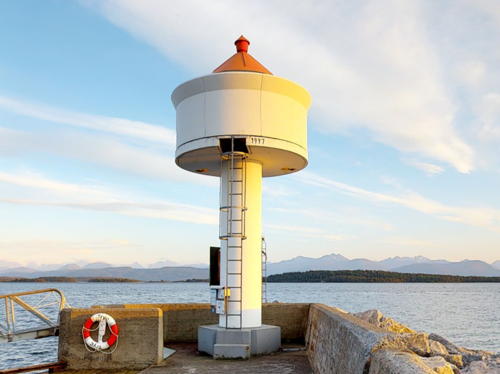
Flatflesa Light, Sandøy, September 2007
ex-Panoramio Creative Commons photo by Eirik Vaage

Sandøy Lighthouses
The former Sandøy municipality occupies a group of islands off the entrance to the Romsdalfjord. The Nordøyvegen Project, completed in 2022, connected Harøy (the main island of Sandøy) to the mainland by a series of bridges between the islands of the former Haram municipality and a tunnel. At the start of 2020 both Sandøy and Haram were merged into a greatly expanded Ålesund municipality.

Brunklegg
Date unknown. Active; focal plane 11 m (36 ft); white, red or green light, depending on direction, occulting three times every 12 s. 6 m (20 ft) lantern and gallery mounted on a stone cairn. Lantern painted white with a red roof. No photo available but Bing has a satellite view. Located on a skerry about 3 km (2 mi) northwest of Fjørtofta and 5 km (3 mi) southwest of Harøy. Accessible only by boat. Site open, tower closed. NF-346100; Admiralty L0882; NGA 6284.
Oksenøyflesa
Date unknown. Active; focal plane 13 m (43 ft); white, red or green light, depending on direction, 2 s on, 2 s off. 8 m (26 ft) lantern mounted on a platform supported by four piles. Lantern painted white with a red roof. No photo available but Bing has an indistinct satellite view. Located on a skerry off the southwestern tip of Oksenøy, an island southwest of Harøy. Accessible only by boat. Site open, tower closed. NF-346200; Admiralty L0883; NGA 6288.
* Marøy
1915. Active; focal plane 28 m (92 ft); white, red or green light, depending on direction, occulting twice every 8 s. 7 m (23 ft) square skeletal tower, covered with white siding, with lantern and gallery. Lighthouse painted white; lantern roof painted red. No photo available but Google has a distant street view and an indistinct satellite view. Located on Marøy, a small island just off Morsund, at the western point of Harøy. Site open, tower closed. NF-347000; Admiralty L0884; NGA 6292.
Skipsholmen
Date unknown. Active; focal plane 15.5 m (51 ft); two flashes every 10 s, white, red or green depending on direction. 11.5 m (38 ft) lantern mounted on a platform supported by four piles. Lantern painted white with a red roof. No photo available but Bing has an indistinct satellite view. Located on a skerry about 5 km (3 mi) northwest of Harøy. Accessible only by boat. Site open, tower closed. NF-347500; Admiralty L0886; NGA 6296.
Steinshamn
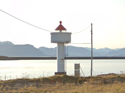
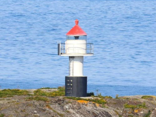
Date unknown. Active; focal plane 10 m (33 ft); white, red or green light, depending on direction, occulting three times every 10 s. 8.5 m (28 ft) concrete post with lantern and gallery. Lighthouse painted white; lantern roof is red. A photo from a Google street view is at right, the light can be seen in aerial photos from Marinas.com, and Google has an indistinct satellite view. Steinshamn, at the northern end of Harøy, was the administrative center of the former Sandøy municipality. Located on an island at the entrance to the harbor of Steinshamn. The island is accessible from the bridge joining Harøy to Finnøy. Site status unknown, probably open; tower closed. NF-348000; Admiralty L0887; NGA 6300.
Kvaløyklubben
Date unknown. Active; focal plane 14 m (46 ft); flash every 5 s, white, red or green light, depending on direction, occulting twice every 8 s. 7 m (23 ft) square tower with lantern and gallery. Lighthouse painted white; lantern roof is red. No photo available but Google has a satellite view. Located on a small island about 1.2 km (3/4 mi) north of Finnøy. Accessible only by boat. Site open, tower closed. NF-348500; Admiralty L0890; NGA 6304.

Steinshamn Light, Sandøy, October 2019
Googel Maps street view
Gåsøy
Date unknown. Active; focal plane 6 m (20 ft); white, red or green light, depending on direction, occulting twice every 8 s. 6 m (20 ft) lantern mounted on a platform supported by four piles. Lantern painted white with a red roof. No photo available but Google has a satellite view. Located on a skerry off the western tip of Gasøy, marking the channel between that island and Finnøy. Accessible only by boat. Site open, tower closed. NF-349000; Admiralty L0892; NGA 6308.
Slantreskjæret (Sandøy)
Date unknown. Active; focal plane 8.5 m (28 ft); white, red or green light, depending on direction, occulting three times every 12 s. 6.5 m (21 ft) square tower with lantern and gallery. Lighthouse painted white; lantern roof is red. Google has a distant street view and a distant satellite view. Located on a skerry in the entrance to the harbor of Sandøy. Accessible only by boat; there are good views from ferries arriving in Sandøy. Site open, tower closed. NF-349700; Admiralty L0898; NGA 6316.
Rugskjæret
Date unknown. Active; focal plane 9 m (30 ft); white, red or green light, depending on direction, 3 s on, 3 s off. 9 m (30 ft) concrete post with lantern and gallery. Lighthouse painted white, lantern roof red. No photo available but Google has a satellite view. Located on a skerry about 1.2 km (3/4 mi) south of Husøy. Accessible only by boat. Site open, tower closed. NF-353100; Admiralty L0913; NGA 6352.
* Husøy
1895. Active; focal plane 28 m (92 ft); white, red or green light, depending on direction, occulting twice every 8 s. 7 m (23 ft) square tower with lantern and gallery. Lighthouse painted white, lantern roof red. Oddgeir Hvidsten's closeup photo is at right, Google has a street view, and Bing has a satellite view. Located on a hill about 1 km (0.6 mi) southwest of Ona. Site open, tower closed. ARLHS NOR-024; NF-354000; Admiralty L0916; NGA 6360.
Husøy Light
Husøy Light, Sandøy, July 2008
Flickr Creative Commons photo by Oddgeir Hvidsten
* Ona
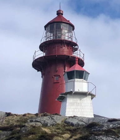
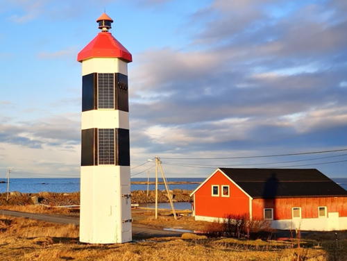
1867. Active; focal plane 40 m (131 ft); continuous white light with a red flash every 30 s. 7 m (23 ft) round cast iron tower with lantern and gallery, painted red. The original rotating Fresnel lens remains in use. The keeper's houses are private residences. The station also has an inactive fog light (bifyr), a 3 m (10 ft) square tower with lantern, painted white with a red lantern roof. Frode Inge Helland's photo is at right, the Lighthouse Association has a page for the lighthouse, Trabas has a photo by Pauline and Wim de Kleine, Kjell Jøran Hansen has a closeup photo, Wikimedia has several photos, and Google has a street view and an indistinct satellite view of the station. Kjetil Eliassen's 2016 photo shows the lighthouse freshly repainted. Scarcely changed in 150 years, this little lighthouse crowns a hill in the center of a remote fishing village accessible by passenger ferry from Gossa. Located on the island of Husøy about 20 km (13 mi) north of Haram. Site open, tower closed. . ARLHS NOR-037; NF-353500; Admiralty L0914; NGA 6356.
Tvinitia
Date unknown. Active; focal plane 12.5 m (41 ft); white, red or green light, depending on direction, occulting once every 6 s. 6.5 m (21 ft) square stone tower with lantern and gallery. Tower painted black, lantern white with a red roof. Google has a distant street view and Bing has a satellite view. NGA describes this as the rear light of a range, but the front light has been dropped from the Norsk Fyrliste. Located on a skerry off the northern tip of Ona. Accessible only by boat. Site open, tower closed. NF-353600; Admiralty L0915.1; NGA 6368.
Flatflesa (3)
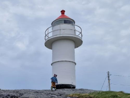
1988 (station established 1902). Active; focal plane 17 m (56 ft); white, red or green light, depending on direction, occulting three times every 10 s. Approx. 11 m (36 ft) round cylindrical fiberglass tower with lantern and gallery. Lighthouse painted white with two narrow black horizontal bands; lantern roof is red. 1-1/2 story wood keeper's house, boathouse, and other light station buildings. Eirik Vaage's photo is at the top of this page, Petri Vuori has a view from the sea, a 2019 photo is available, and Bing has a satellite view of the area. Accommodations are available in the keeper's house. Wikipedia's page has a historic photo of the original lighthouse. In 1939 the light was moved to a 20 m (66 ft) iron tower next to the keeper's house. Located on a small island about 4 km (2.5 mi) west of the island of Gossa. Accessible only by boat; there should be a view from ferries between Gossa and Harøy. Site open, tower closed. Site manager: Classic Norway Hotels (Flatflesa Fyr ). ARLHS NOR-082; NF-352500; Admiralty L0910; NGA 6340.

Ona Light, Sandøy, September 2010
Wikimedia Creative Commons photo by Frode Inge Helland

Rauma Lighthouse
Herjeskjæret
Date unknown. Active; focal plane 7 m (23 ft); two flashes every 10 s, white, red or green depending on direction. 7 m (23 ft) lantern mounted on a stone cairn. Lantern painted white with a red roof. Trabas has Siering's photo, Google has a very distant street view, and Bing has a distant satellite view. Located on a skerry in the entrance to the Langfjord, off Åfarnes. Accessible only by boat, but there's a view from ferries crossing the fjord between Åfarnes and Sølsnes. Site open, tower closed. NF-365300; Admiralty L0978; NGA 6508.

Midsund Lighthouse
Drønesundvågen
Date unknown. Active; focal plane 7.5 m (25 ft); white, red or green light, depending on direction, occulting twice every 8 s. 6.5 m (21 ft) concrete post with lantern and gallery. Lighthouse painted white, lantern roof red. Trabas has Boucher's distant photo, Google has a distant street view, and Bing has an indistinct satellite view. Located on a promontory on the southwest side of Midøya. Site status unknown. NF-358800; Admiralty L0942.4; NGA 6436.

Molde Lighthouses
Hjertøytangen
Date unknown. Active; focal plane 7.5 m (25 ft); white, red or green light, depending on direction, occulting three times every 10 s. 10.5 m (34 ft) concrete post with lantern and gallery. Lighthouse painted white, lantern roof red. Trabas has Andreas Köhler's photo and Google has a distant satellite view. A familiar sight to passengers on ferries between Vestnes and Molde, this light marks the beginning of the approach to Molde. Located off the west end of Hjertøya, about 4 km (2.5 mi) southwest of Molde. Accessible only by boat. Site open, tower closed. NF-359700; Admiralty L0950; NGA 6456.
Årøy
Date unknown. Active; focal plane 11 m (36 ft); white, red or green light, depending on direction, occulting once every 6 s. 11 m (36 ft) airport control tower; the light is shown from a tripod mast on the roof. Trabas has Andreas Köhler's photo, another photo is available and Google has a satellite view and a distant street view. Molde's airport stretches alongside the Romsdalfjord. Located on the north side of the fjord about 3 km (1.8 mi) east of Molde harbor. Site and tower closed. NF-362000; Admiralty L0956; NGA 6476.
* Molde (1)
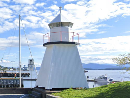
Date unknown. Inactive. 7 m (23 ft) square wood tower with lantern and gallery, painted white. Michel Moré has a closeup photo, Bash's photo is at right, and Google has a street view and a satellite view. Located at the foot of the Reknes mole on the Molde waterfront. Site open, tower closed.
* Molde (2)
Date unknown. Active; focal plane 9.5 m (31 ft); white, red or green light, depending on direction, occulting twice every 8 s. 7.5 m (25 ft) concrete post with lantern and gallery. Lighthouse painted white, lantern roof red. Bash's photo is at right, Trabas has Siering's closeup photo, Wikimedia has a photo by Joachim Müllerchen showing both lights, and Google has a closeup street view and a satellite view. Located on the west end of the Reknes Mole in Molde harbor. Accessible by walking the mole. Site open, tower closed. . NF-359900; Admiralty L0952; ex-NGA 6459.

Aukra Lighthouses
Midtfjordskjæra
Date unknown. Active; focal plane 8 m (26 ft); white, red or green light, depending on direction, 3 s on, 3 s off. 7 m (23 ft) concrete post with lantern and gallery. Lighthouse painted white, lantern roof red. No photo available but Google has a satellite view. Located on a skerry in the center of the Grunnefjord, halfway between Gossa and Otrøy. Accessible only by boat. Site open, tower closed. NF-351000; Admiralty L0907; NGA 6328.
Kvitskjær
Date unknown. Active; focal plane 7.5 m (25 ft); white, red or green light, depending on direction, occulting twice every 8 s. 6 m (20 ft) concrete post with lantern and gallery. Lighthouse painted white, lantern roof red. No photo available but Google has a satellite view. Located on a skerry about 3 km (2 mi) southwest of Småge. Accessible only by boat. Site open, tower closed. NF-352200; Admiralty L0907.8; NGA 6344.
Søre Orholmskjæret (Sondre Orholmskjaer)
Date unknown. Active; focal plane 7.5 m (25 ft); white, red or green light, depending on direction, occulting twice every 8 s. 6 m (20 ft) lantern mounted on a platform supported by piles. Lantern painted white with a red roof. No photo available but Google has a satellite view. Located on a skerry about 2.5 km (1.5 mi) northwest of Gossa. Accessible only by boat. Site open, tower closed. NF-355500; Admiralty L0922; NGA 6384.


Original Molde Light, Molde, October 2010
Flickr Creative Commons photo by C.W. Bash

Molde Fyr
New Molde Light, Molde, October 2010
Flickr Creative Commons photo by C.W. Bash


Fræna Lighthouses
* Bjørnsund (2)
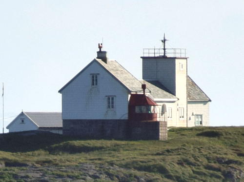
1974. Active; focal plane 26 m (85 ft); white, red or green light, depending on direction, occulting twice every 8 s. 9 m (30 ft) square cylindrical wood tower with gallery, attached to one end of a 1-story wood keeper's house. House painted white, lantern red. Trabas has Jim Smith's photo seen at right, Wikimedia has Gunvor Røkke's distant view, Tony Yates has a good street view, and Google has a satellite view of the station. The keeper's cottages provide vacation housing for Kystverket employees. Located on Moøya, a small island about 4 km (2.5 mi) north of Gossa and the same distance west of Bud. Accessible only by boat. Site status unknown. ARLHS NOR-057; NF-355000; Admiralty L0918; NGA 6372.
* Bjørnsund (1)
1871. Inactive. Lantern attached to one corner of a 1-1/2 story keeper's house. Trabas has Jim Smith's photo seen at right. Located next to the original lighthouse. Site status unknown. .
Hammerøyskjæret
Date unknown. Active; focal plane 6.5 m (21 ft); white, red or green light, depending on direction, 3 s on, 3 s off. 4.5 m (15 ft) octagonal lantern on an octagonal base. Lantern painted white, lantern roof red, base black. Lightphotos.net has Ranveig Marie's photo and Google has a satellite view. Located on a skerry off Austre Hammerøya about 800 m (1/2 mi) east of the Bjørnsund lighthouse. Accessible only by boat. Site open, tower closed. NF-355100; Admiralty L0920; NGA 6376.
 
Harøyodden (Indre Harøy)
Date unknown. Active; focal plane 19 m (62 ft); white, red or green light, depending on direction, occulting once every 4 s. 6 m (20 ft) square tower with lantern and gallery. Lighthouse painted white, lantern roof red. Trabas has Ronald Wöhrn's photo and Bing has a satellite view. Located on the southwestern tip of Indre Harøy, about 4 km (2.5 mi) southeast of Bud. Site status unknown. NF-356800; Admiralty L0929; NGA 6400.

1871 Bjørnsund Light, Fræna
photo copyright Jim Smith; used by permission
Storesundet
1915. Active; focal plane 12 m (39 ft); two flashes every 10 s, white, red or green depending on direction. 8 m (26 ft) lantern and gallery mounted on four straight piles. Lantern painted white with a red roof, piles painted black. Lightphotos.net has Andreas Köhler's photo and Bing has a satellite view. Located on a rocky island on the north side of the west entrance to the harbor of Bud. Accessible only by boat. Site open, tower closed. NF-356100; Admiralty L0926; NGA 6392.
Romsdalsholmen
Date unknown. Active; focal plane 7 m (23 ft); white, red or green light, depending on direction, occulting twice every 8 s. 9.5 m (31 ft) lantern mounted on a platform supported by piles. Lantern painted white with a red roof, piles painted black. No photo available but Google has a satellite view. Located on a tiny skerry about 5 km (3 mi) northeast of Bud. Accessible only by boat. Site open, tower closed. NF-368000; Admiralty L0991; NGA 6524.
Vikan
Date unknown. Active; focal plane 13 m (43 ft); flash every 5 s, white, red or green, depending on direction, occulting once every 6 s. 11.5 m (37 ft) concrete post with lantern and gallery. Lighthouse painted white; lantern roof painted red. No photo available but Google has a satellite view. Located on a skerry off the coast of Fræna near Vikan. Accessible only by boat. Site open, tower closed. NF-368200; Admiralty L0992; NGA 6528.
* Askvåg (Askvågen, Haugeneset)
1913. Active; focal plane 11 m (36 ft); white, red or green light, depending on direction, occulting twice every 8 s. 7 m (23 ft) square skeletal tower, covered with wood siding, with lantern and gallery. Lighthouse painted white; lantern roof painted red. Trabas has Siering's 2015 photo, Lightphotos.net has Andreas Köhler's closeup photo, Yana Okhman has a 2017 photo, and Google has a satellite view. Located on the ocean shore about 13 km (8 mi) northeast of Bud. Site open, tower closed. NF-369100; Admiralty L0997; NGA 6552.
Fuglen
Date unknown. Active; focal plane 13.5 m (44 ft); white, red or green light, depending on direction, 3 s on, 3 s off. 14.5 m (47 ft) lantern mounted on six slender piles. A much older stone cairn is next to the modern light. Trabas has Siering's photo (also seen at right) but Bing has only a fuzzy satellite view of the skerry. This important light is missing from the NGA List. Located on an isolated and dangerous reef about 8 km (5 mi) off the north coast of Fræna. Accessible only by boat. Site open, tower closed. NF-370100; Admiralty L1001.
Kusundet (Kusund)
Date unknown. Active; focal plane 7 m (23 ft); white, red or green light, depending on direction, occulting twice every 8 s. 8.5 m (28 ft) lantern mounted on a platform supported by tripod piles. Lantern painted white with a red roof. Trabas has Siering's photo but Google has only a fuzzy satellite view of the location. Located off the east end of the island of Store Moldvaren, guiding vessels into a protected sound. Accessible only by boat. Site open, tower closed. NF-369700; Admiralty L1000; NGA 6568.
Fuglen Light
Fuglen Light, Fræna, June 2012
photo copyright Arno Siering; used by permission

Information available on lost lighthouses:

Notable faux lighthouses:

Adjoining pages: North: Nordmøre (Kristiansund Area) | South: Sunnmøre (Ålesund Area)

Return to the Lighthouse Directory index | Ratings key

Posted June 19, 2006. Checked and revised June 7, 2023. Lighthouses: 32. Site copyright 2023 Russ Rowlett and the University of North Carolina at Chapel Hill.