Lighthouses of Australia: Southern New South Wales

The independent Commonwealth of Australia occupies the entire Australian continent, the island of Tasmania, and numerous smaller islands. British exploration and settling of the continent began late in the 1700s, with the first colony established in the Sydney area in 1788. By the 1850s there were six British colonies, including New South Wales and Queensland in the east, Victoria and South Australia in the south, Western Australia in the west, and Tasmania off the south coast. The Commonwealth was formed on New Years Day 1901 as a federation of the six colonies.

Australia is both the smallest continent and the sixth-largest country in the world, with a population of about 26 million. It continues to be a federation of the six original states, plus the federally administered Northern Territory, Australian Capital Territory, and Jervis Bay Territory. It is a Commonwealth Realm recognizing the British monarch as head of state.

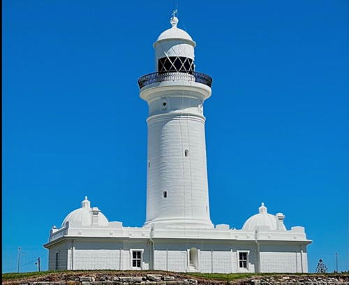
Located in the southeastern part of Australia, the state of New South Wales faces east on the Tasman Sea and includes the nation's largest metropolitan area, Sydney. It has about 35 historic light stations and an impressive collection of surviving lighthouses. Many of these lighthouses were built during a single decade, 1875-1885, on designs drawn by James Barnet (1827-1904), who held the post of Colonial Architect from 1862 to 1890. The lanterns and galleries of Barnet's lighthouses have a distinctive and elegant style illustrated by the Montague Island lighthouse shown at the right.

Most New South Wales lighthouses are accessible but only a few are open for climbing. Although there is no state preservation society there have been a number of successful local preservation efforts.

Included on this page are the lighthouses of Port Jackson (Sydney Harbour) and the coast between Sydney and the Victoria border. Also included is the former Cape St. George Light, which is in the federal Jervis Bay Territory although it is surrounded by New South Wales.

Coastal aids to navigation in Australia are maintained by the Australian Maritime Safety Authority (AMSA) but often AMSA manages only the lighting equipment. Harbor lights are maintained by NSW Maritime or by the Port Authority of New South Wales (formerly Sydney Ports). Some of the light stations are parklands managed by the N.S.W. Department of Planning and Environment. Many of the others are managed by the N.S.W. Crown Land Division.

ARLHS numbers are from the ARLHS World List of Lights, Admiralty numbers are from volume K of the Admiralty List of Lights & Fog Signals, and U.S. NGA numbers are from NGA Publication 111.

General Sources
Lighthouses of New South Wales
The section of the Lighthouses of Australia site devoted to New South Wales lights.
AMSA Heritage Lighthouses
An interactive map links to information and photos for the major AMSA lighthouses.
Lighthouses and Lightvessels in Australia - New South Wales
Index to Wikipedia articles; most include photos.
World of Lighthouses - New South Wales
Photos by various photographers available from Lightphotos.net.
Online List of Lights - Australia
Photos by various photographers posted by Alexander Trabas. Many of the photos for New South Wales are by Michael Boucher.
Grant and Tracey's Lighthouse Page - New South Wales
Older photos of most of the lighthouses posted by Grant Maizels.
Brett Matthews - Lighthouses
A fine collection of photos of Australian lighthouses, mostly in New South Wales.
Leuchttürme Australiens und Ozeaniens auf historischen Postkarten
Historic postcard images posted by Klaus Huelse.
GPSNauticalCharts
Navigation chart information for New South Wales.
Navionics Charts
Navigation chart for New South Wales.


Montague Island Light, April 2023
Google Maps photo
by Trevor Carter

Port Jackson (Sydney Harbour) Lighthouses

Sydney, the capital of New South Wales and Australia's largest city, is centered at the west end of Port Jackson, a ria or drowned river valley about 19 km (12 mi) long. The entire inlet is often called Sydney Harbour although officially that term applies only to the innermost section. Terminology aside this is one of the world's most magnificent natural harbors. The metropolitan population of Sydney is about 5.3 million (roughly 20% of all Australians).

Northern Beaches Council Area Lightbeacon
* [Outer North Head (Fairfax Lookout)]
Date unknown. Active; focal plane 73 m (240 ft); green light, 1 s on, 1 s off. Approx. 15 m (49 ft) square white mast. Brendan Millett has a 2020 photo, Trabas has Erich Hartmann's photo, Google has a street view, and Bing has a satellite view. An observation platform adjoining the light offers a spectacular view. Located atop a 60 m (200 ft) cliff on the north side of the entrance to Port Jackson. Accessible by walking the Fairfax Track, an easy 1 km (0.6 mi) walk..Site open, tower closed. Operator: Port Authority of NSW. Site manager: NSW National Parks (Sydney Harbour National Park). . Admiralty K2637; NGA 6176.

Mosman Lighthouses
* Grotto Point (Port Jackson Entrance Range Front)
1911 (Maurice Festu). Active; focal plane 19 m (61 ft); light occulting four times every 15 s; white shown on the range line, red to the right and green to the left. Approx. 8 m (26 ft) round domed concrete tower attached to a service building, all painted white. The lights are shown through a horizontal window about 2/3 of the way up the tower. A photo is at right, Lighthouses of Australia has a page for the light, Gillian Rodgers has an excellent closeup photo, Trabas has Boucher's closeup photo, a 2008 closeup is available, Simon Pei has a 2021 photo, Wikimedia has a photo and several historic photos, and Google has a street view and a satellite view. Located in dense forest on a steep, rocky headland on the north side of the harbor, south of Balgowlah Heights in Mosman. Accessible by a hiking trail off the Manly Scenic Walkway. Site open, tower closed. Operator: Port Authority of NSW. Site manager: NSW National Parks (Sydney Harbour National Park). . ARLHS AUS-087; Admiralty K2638; NGA 6184.
* Rosherville (Parriwi Head, Port Jackson Entrance Range Rear)
1911 (Maurice Festu). Active; focal plane 43 m (142 ft); green flash every 3 s. Approx. 15 m (50 ft) round domed concrete tower, painted white; the light is shown through a window just below the dome. Lighthouses of Australia has a page for the light, Albert Chetcuti has a closeup photo, Trabas has Boucher's photo, a 2021 photo and a 2010 photo are available, and Google has a street view and a satellite view. Located on Parriwi Road north of Cyprian Street, on the south side of Middle Harbour in Mosman. Site open, tower closed. Operator: Port Authority of NSW. Site manager: Mosman Municipal Council (Parriwi Lighthouse Park). . ARLHS AUS-145; Admiralty K2638.1; NGA 6188.

Grotto Point Light, Mosman, January 2023
Google Maps photo by YamY FR
Western Channel Pile Light (2)
2008 (station established 1924). Active; focal plane 9.5 m (31 ft); red light occulting once every 3 s. 11 m (36 ft) octagonal cylindrical tower with lantern and two galleries, mounted on piles. Lighthouses of Australia has a page for the light, Trabas has Erich Hartmann's photo, a closeup is available, Mic Vasselin has a photo, and Google has a satellite view. The lighthouse marks the western end of the Sow and Pigs Shoal. Sydney Ports had slated the lighthouse for replacement in 2007, but James Wood's photo taken in May 2006 shows the lighthouse leaning dangerously. It collapsed into the water on the afternoon of 12 December 2006. The lighthouse was reconstructed using the original lantern on a new tower replicating the original; the light was reactivated on 18 December 2008. Located in the harbor between Vaucluse Point on the south and Georges Head on the north side of the harbor. Accessible only by boat. Site and tower closed. Operator: Port Authority of NSW. ARLHS AUS-286; Admiralty K2644; NGA 6192.
* Bradley's Head
1905. Active; focal plane 7 m (22 ft); green light, occulting every 3 s. 6 m (20 ft) round cylindrical tower with lantern and gallery, painted white, mounted on a rock and connected to shore by a footbridge. Fog horn (four blasts, the first one 10 s and the others 4 s, every 30 s). Flavia Zancanaro has a 2019 closeup photo, Wikimedia has many photos, Trabas has Rainer Arndt's photo, Lighthouses of Australia has a page for the lighthouse, Jacques Halans has a photo and a street view, and Google has a satellite view. This little lighthouse is located at the end of Bradley's Head, a point that projects into the north side of Sydney Harbour and commands a spectacular view. Parking is available at the end of Bradley's Head Road in Mosman. Standing nearby is the foremast of the World War I era cruiser HMAS Sydney. Site open, tower closed. Operator: Port Authority of NSW. Site manager: NSW National Parks (Sydney Harbour National Park). . ARLHS AUS-243; Admiralty K2662; NGA 6216.

North Sydney Lighthouse
* Robertson Point (Cremorne Point)
1910. Active; focal plane 8 m (25 ft); green light, occulting every 3 s. 8 m (26 ft) round cylindrical tower with lantern and gallery, painted white, mounted on a rock and connected to shore by a footbridge. A 2022 photo is at right, Alan Chen has a 2018 photo, Lighthouses of Australia has a page for the light, Gillian Rodgers has a closeup photo, Trabas has Rainer Arndt's photo, Wikimedia has photos, Jean-Jacques Halens has a street view, and Google has a satellite view. Sibling of Bradley's Head Light. Located beyond the southern end of Milson Road in North Sydney. Parking is available at the end of Milson Road. Site open, tower closed. Operator: Port Authority of NSW. Site manager: North Sydney Municipal Council (Cremorne Point Reserve). . ARLHS AUS-176; Admiralty K2664; NGA 6220.

Robertson Point Light, North Sydney, November 2022
Instagram photo by benjawan_l

Downtown Sydney Lighthouses
* Fort Denison (Pinchgut)
1913. Active; focal plane 19 m (61 ft); four white flashes, separated by 2 s, every 15 s. 6 m (20 ft) round tower with lantern and gallery, mounted on a round 19th century stone fortification (a Martello tower). Lantern painted black. Fog bell. A 2022 photo is at right, Lighthouses of Australia has a page for the light, Trabas has Thomas Philipp's photo, Wikimedia has many photos, Jean-Jacques Halens has a street view, and Google has a satellite view. In October 2003 the lantern of the lighthouse was removed for restoration; it was returned in May 2004. Fort Denison (1857) is a historic monument on a small island in Sydney Harbour just downstream from the famous Harbour Bridge. The island is open to guided tours (reservations required; fee). Site open, tower closed. Operator: Port Authority of NSW. Site manager: NSW National Parks (Sydney Harbour National Park). . ARLHS AUS-235; Admiralty K2666; NGA 6224.
* Blues Point
Date unknown. Active; focal plane 18 m (59 ft); green light, 1 s on, 1 s off. 17 m (56 ft) slender octagonal skeletal tower painted white. Trabas has Erich Hartmann's photo and Google has a street view and a satellite view. Blues Point is a narrow peninsula projecting into the north side the harbor west of the Sydney Harbour Bridge. Located in the Blues Point Reserve, a park at the tip of the peninsula commanding a great view of the bridge. Site open, tower closed. Admiralty K2688; NGA 6268.
* [Goat Island (Leading) (2)]
Date unknown. Active; focal plane 13 m (43 ft); white light, 2 s on, 1 s off. Approx. 10 m (33 ft) post painted white. Trabas has Erich Hartmann's photo and Google has a street view and an indistinct satellite view. NGA describes an octagonal wood tower, so the current light apparently replaced a small lighthouse. Goat Island is located off Darling Harbour west of the Sydney Harbour Bridge. It has a long and colorful history as a quarry, convict stockade, explosives store, police station, fire station, boatyard and film set. The light is on the northeast point of the island. Site open, tower closed. Site manager: NSW National Parks (Sydney Harbour National Park). Admiralty K2695; NGA 6272.
Goat Island A Range Front
Date unknown. Active; focal plane about 20 m (66 ft); continuous green light. Approx. 12 m (39 ft) square cylindrical concrete tower carrying a large rectangular green daymark. Trabas has Boucher's photo of the two range lights and Google has a satellite view. The range guides vessels exiting Darling Harbour. Located on the east side of the island. Site status unknown. Admiralty K2692; NGA 6276.

Fort Denison Light, Sydney, June 2022
Instagram photo by MV Cape Don/Moreton/Pillar
Goat Island A Range Rear
Date unknown. Active; focal plane about 24 m (79 ft); continuous green light. Approx. 12 m (39 ft) square cylindrical concrete tower carrying a large rectangular green daymark. Trabas has Boucher's photo and Bing has a satellite view. Located 55 m (60 yd) north of the front light. Site status unknown. Admiralty K2692.1; NGA 6280.
*** Cape Bowling Green (relocated)
1874 (relocated 1987). Reactivated (unofficial, maintained by the museum); focal plane about 19 m (60 ft); four white flashes every 20 s. 16 m (50 ft) round frame tower covered by galvanized iron sheets, with lantern and gallery. Built on Cape Bowling Green about 75 km (45 mi) south of Townsville, Queensland, this lighthouse was relocated twice to escape beach erosion. The lighthouse was replaced and dismantled in 1987. Under AMSA's sponsorship it has been reassembled and reactivated, with its original 3rd order Chance Brothers lens and its original characteristic. A 2022 photo is at right, Liz Lawley has a 2009 closeup, Oscar Navarro has a 2022 photo, Wikimedia has several photos, and Google has a street view and a satellite view. Located on the wharf at the Australian National Maritime Museum at Darling Harbour a short distance south of the Sydney Harbour Bridge. Site and tower open to guided tours daily. Owner/site manager: Australian National Maritime Museum (Cape Bowling Greeen Lighthouse). . ARLHS AUS-246.
* Lightfloat CLS-4 Carpentaria
1917. Decommissioned 1983. 22 m (72 ft) single-masted steel lightship; round cylindrical light tower with lantern amidships. During its career the ship served in the Gulf of Carpentaria; off Breaksea Spit near Sandy Cape, Queensland; and in Bass Strait. Entire ship painted red. Mike Abrams has a 2023 photo, Nicholas Cull has a photo, and Google has a street view and a satellite view. Since 1987 the ship has been moored at the wharf at the Australian National Maritime Museum at Darling Harbour a short distance south of the Sydney Harbour Bridge. Site open daily. Owner/site manager: Australian National Maritime Museum. ARLHS AUS-053.
* Dawes Point Northwest (2)
Date unknown. Active; focal plane 12 m (39 ft); red light, 2 s on, 1 s off. Light mounted above the second floor balcony of the Pier One Sydney Hotel. Trabas has Boucher's photo and Google has a satellite view. NGA describes a light on a "shed." Located on the waterfront west of the south end of the famous Sydney Harbour Bridge. Site open, tower closed. Admiralty K2686; NGA 6261.
* Dawes Point
1948. Active; focal plane 7 m (23 ft); continuous red light. 4 m (13 ft) square unpainted concrete tower. Trabas has a photo by Günther Hess and Google has a street view and a satellite view. Located on the waterfront east of the south end of the famous Sydney Harbour Bridge. This site has a great view of the equally famous Sydney Opera House. Site open, tower closed. Admiralty K2684; NGA 6260.

Cape Bowling Green Light, Sydney, September 2022
Google Maps photo by yihshintw

Concord West (Parramatta River) Lighthouse
Rocky Point
Date unknown. Active; focal plane 5 m (16 ft); red flash every 2 s. Light mounted on the second-story windowsill of a 2-story brick pierhead building. Trabas has Boucher's photo and Google has a satellite view. The Parramatta River is the largest of the upper forks of Sydney Harbour. Located on a promontory of the south side of the estuary, part of the campus of the Rivendell School. Best seen from the water. Admiralty K2698.8.

Vaucluse Area (Woollahra Council Area) Lighthouses
Vaucluse is a mostly residential suburb of Sydney. The city spans the South Head Peninsula, the headland on the south side of the entrance to Port Jackson; it has a west coast on Port Jackson and an east coast on the Tasman Sea.
Shark Island
1913. Active; focal plane 12 m (40 ft); three red flashes every 8 s. 12 m (40 ft) round cylindrical tower with lantern and gallery, painted white. Lighthouses of Australia has a page for the light, Christian Polsinelli has an excellent closeup, Trabas has a closeup by Günther Hess, Wikipedia's article also has a historic photo, and Google has a satellite view and a street view from the northern tip of the island. Shark Island is open to the public but capacity is limited to 30 and reservations are required. Located just off the northern point of an island in Sydney Harbour, 1 km (0.6 mi) southeast of Bradley's Head and west of Vaucluse. Accessible only by boat; visible at close range from the island and at longer range from the Bradley's Head Light and from many places in Vaucluse. Site open, tower closed. Operator: Port Authority of NSW. Site manager: NSW National Parks (Sydney Harbour National Park). ARLHS AUS-267; Admiralty K2656; NGA 6208.
* Vaucluse
Date unknown. Active; focal plane 129 m (423 ft); white or red light occulting once every 3 s. Approx. 25 m (82 ft) round unpainted concrete water tower. Trabas has Jim Smith's photo and Google has a street view and a satellite view. The red sector apparently warns outbound vessels from straying from the channel in Port Jackson. Located on Clairvaux Road at Black Street in Vaucluse. Site and tower closed, but the tower is easy to see from the street. Admiralty K2653; NGA 6206.
* Vaucluse Bay Range Rear
1884 (Maurice Festu). Active; focal plane 84 m (275 ft); continuous red light. 8 m (26 ft) round cylindrical tower with a conical roof; the light is displayed through a window. Tower painted white. Trabas has Jim Smith's photo, Lighthouses of Australia has a page for the range lights and Google has a street view and a satellite view. Located 945 m (0.59 mi) south of the front light, in the front garden of the house at 12 Wentworth Road in Vaucluse. Site and tower closed, but the lighthouse is easily seen from the street. Operator: Port Authority of NSW. Site manager: private. ARLHS AUS-285; Admiralty K2650.1; NGA 6204.
Vaucluse Bay Range Front
1884 (Maurice Festu). Active; focal plane 16 m (52 ft); continuous red light. 8 m (26 ft) round cylindrical tower with a conical roof; the light is displayed through a window. Tower painted white. Trabas has Boucher's photo, Lighthouses of Australia has a page for the range lights including a photo of the front light, Joshua Niland has a 2021 photo, and Google has a satellite view. Located on the bay side of 80 Wentworth Road, on the east side of the entrance to Vaucluse Bay in Vaucluse. There is no view from the street, so the lighthouse is best seen from the water. Site and tower closed. Operator: Port Authority of NSW. Site manager: private. ARLHS AUS-178; Admiralty K2650; NGA 6200.

Vaucluse Bay Range Front Light, Vaucluse, April 2014
Wikimedia Creative Commons photo by MorePix
Eastern Channel Pile Light (2)
1924 (station established 1908). Active; focal plane 9.5 m (31 ft); green light occulting once every 3 s. 11 m (36 ft) octagonal cylindrical tower with lantern and two galleries, mounted on piles. Lighthouses of Australia has a page for the light, Dietmar Rabich has a 2019 photo, Anil Mishra has a 2023 photo, Trabas has Rainer Arndt's photo, and Google has a satellite view. The lighthouse marks the eastern end of the Sow and Pigs Shoal. The lighthouse has been restored by Waterways Construction, so it should be in safe condition. Located in the harbor off Laing's Point in Vaucluse; there must be a good view from the Laing's Point Reserve at the end of Pacific Street. Accessible only by boat. Site and tower closed. Operator: Sydney Ports. ARLHS AUS-284; Admiralty K2652; NGA 6196.
* [Green Point Obelisk]
1850s. Inactive daybeacon. Approx. 6 m (20 ft) square solid stone tower. Wikimedia has a photo, Phupakorn Dangrungroj has a 2023 photo, Chris Norton has a street view, and Google has a satellite view. Located on a point of land overlooking Port Jackson in Watsons Bay; the Green Point Walking Track passes the obelisk. Site open, tower closed.
* Hornby (South Head Lower)
1858 (Alexander Dawson). Active; focal plane 27 m (90 ft); white light, 2 s on, 3 s off. 9 m (30 ft) round sandstone tower with lantern and gallery, painted with red and white vertical stripes. Several 1-story sandstone keeper's quarters. A photo is at right, a 2021 photo is available, Katka Pruskova has a 2013 closeup showing the lighthouse freshly painted, Trabas has Thomas Philipp's closeup, Wikipedia's article has several photos, Huelse has a historic postcard view, and Google has a street view and a satellite view. João Azevedo has a photo of the two 1858 keeper's cottages. This is the third oldest light station and second oldest surviving lighthouse in New South Wales; the lighthouse was built after two shipwrecks in 1857 caused great loss of light. The lighthouse deteriorated after the light was automated in 1933 and was in poor condition when the station was transferred to the park service in 1977. After automation the keeper's houses were used to house Army families. NSW National Parks restored the entire station after it assumed ownership and continues to maintain it. In 2023 the lighthouse was added to the state's Historic Register. Located on the headland at the southern entrance to Jackson Bay and Sydney Harbour, north of the town of Watson's Bay. Accessible by a short walk from parking at Camp Cove, at the foot of Cliff Street in Watson's Bay. Site open, tower closed. Operator: Port Authority of NSW. Site manager: NSW National Parks (Sydney Harbour National Park). . ARLHS AUS-093; Admiralty K2636; NGA 6180.


Hornby Light, Vaucluse, February 2021
Google Maps photo by Javed T.


Eastern Vaucluse (Waverley Council Area) Lighthouse
** Macquarie (South Head Upper) (2)
1883 (James Barnet) (station established 1818). Active; focal plane 105 m (344 ft); two white flashes every 10 s; tower floodlit at night. 26 m (85 ft) round sandstone tower with lantern and gallery attached to a 1-story sandstone keeper's house. Entire lighthouse painted white. 4th order bivalve Fresnel lens (1933) in use. Head keeper's house (1840) and assistant keeper's house (1881). Additional modern assistant keeper's houses (1970) are leased to private caretakers; in 2004 one of these leases was for sale for AU$1.95 million. This is Australia's oldest light station (a wood and coal-fired beacon on a tripod was in use as early as 1793), and this is probably its best-known lighthouse. Barnet's design is based on Francis Greenway's design of the 1818 lighthouse; foundations of the earlier lighthouse are visible. A rare gas-powered generator (state of the art in 1883) is on display. A photo by Chris Collins is at right, Scott Davies has a good photo, the Harbour Trust has a page for the light station, Wikipedia's article has several photos, Trabas has an excellent photo by Boucher, Huelse has a historic postcard view, and Google has a street view and a good satellite view. The first lighthouse was built of soft sandstone that did not stand up to the weather. The present lighthouse was automated in 1976 but continued to be staffed until 1989. The grounds were transferred to the Harbour Trust in 2001. In 2007 the bimonthly guided tours of the lighthouse were suspended to permit interior restoration work. Tours resumed in early 2008. In 2014 one of the keeper's houses was on sale for $7 million; it sold in 2016 to businessman Jianmin Song. In 2019 Song had the property for sale again, this time for $8.8 million. In 2023 one of the keeper's houses was for sale for $12 million. The lighthouse is about 3 km (2 mi) south of the entrance to Port Jackson (Sydney Harbour). Located on Old South Head Road in Vaucluse; parking provided. Ferries link Vaucluse to downtown Sydney, and city buses also operate to the site. Site open; tower open only to tours (reservations required) normally on the fourth Sunday of February, April, June, August, and October. Operator: AMSA. Site manager: Sydney Harbour Federation Trust. . ARLHS AUS-218; Admiralty K2632; NGA 6316.

Macquarie Light, Vaucluse, February 2023
Google Maps photo by Chris Cousins

South Coast Lighthouses

Botany Bay Lighthouses
Botany Bay is an elliptical bay on the south side of the Sydney metropolitan area. Captain James Cook made his first landing in Australia here on 29 April 1770. Today the bay is Sydney''s principal cargo port.
* Endeavour (Henry Head)
1955. Active; focal plane 27 m (87 ft); white light, 2 s on, 1 s off. Mast atop a 4 m (13 ft) round masonry tower, painted white. Trabas has Jim Smith's closeup photo, another photo is available, and Google has a street view and a satellite view. The lighthouse is named for Captain Cook's flagship Endeavour. Located in La Perouse, a community in the City of Randwick, on a headland on the north side of the entrance to Botany Bay, adjacent to the New South Wales Golf Club. Accessible by a short walk from the La Pérouse Museum. Site open, tower closed. Operator: AMSA. Site manager: NSW National Parks (Kamay Botany Bay National Park). . ARLHS AUS-268; Admiralty K2623; NGA 6324.
Botany Bay (Leading Light)
Date unknown. Active; focal plane 17 m (56 ft); continuous white, red or green light depending on direction; in narrow bands at the edges of the white sector the light alternates between white and red or white and green. 15 m (49 ft) square skeletal tower. Trabas has Rainer Arndt's photo and Google has a satellite view. This is the main entry light for Botany Bay.The Admiralty renumbered it in 2023. Located at the water's edge beyond the end of Runway 34 Left of Sydney Airport, within the Bayside Council Area. Site and tower closed. Admiralty K2627.81 (ex-K2624); NGA 6327.
Cape Baily
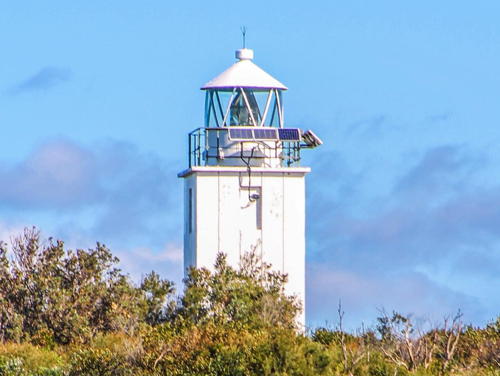
1950. Active; focal plane 55 m (180 ft); four white flashes, separated by 2 s, every 16 s. 9 m (30 ft) square cylindrical concrete tower with lantern, painted white. Solar-powered lens. A 2022 photo is at right, Brett Matthews has a great closeup photo, Wikipedia's article has a photo, Trabas has Rainer Arndt's photo, Maurice van Creij has a closeup street view, and Google has a satellite view. Located in Kurnell, a suburban village in Sutherland Shire, on the headland at the south side of the entrance to Botany Bay, directly opposite the Endeavour Light. Accessible by a hike of about 2.5 hours round trip from the end of Solander Road in Kurnell. Site open, tower closed. Operator: AMSA. Site manager: NSW National Parks (Kamay Botany Bay National Park). . ARLHS AUS-019; Admiralty K2622; NGA 6404.

Cape Baily Light, Kurnell, July 2022
Instagram photo by in.her.sights

Wollongong Lighthouses
Wollongong is the third largest city of New South Wales with a population of about 300,000. It is an industrial center and an important seaport.

*
Wollongong Harbour (Wollongong Breakwater)
1871 (Edward O. Moriarty). Inactive since 1974 (a decorative light is displayed on special occasions). 12 m (40 ft) tapered round wrought iron tower with lantern and gallery, painted white. Bernard Spragg's photo is at right, Doug Barton has a good closeup photo, Renee Tenhave has a 2018 photo, Wikipedia's article also has a closeup, Brett Matthews has a photo of both Wollongong lighthouses, Huelse has a historic postcard view, and Google has a street view and a satellite view. The lighthouse was seriously deteriorated before a 1978-79 restoration stabilized its condition. In 2000-02 a complete restoration returned the lighthouse and its lighting equipment to its original configuration, and the light was relit in connection with an international lighthouse conference in Sydney. An active light (focal plane 8 m (26 ft); red flash every 3 s) is displayed from a red post at the end of the extended breakwater; Trabas has Boucher's photo and Ric Noble has a street view that also shows both Wollongong lighthouses. Located at the original end of the breakwater on the southeast side of Wollongong Harbour; easily accessible by walking the breakwater. Owner/site manager: NSW Crown Lands Division. Site open, tower closed. . ARLHS AUS-172. Active light: Admiralty K2616; NGA 6420.
* [Wollongong Entrance Range Rear]
Date unknown. Active; focal plane unknown; continuous blue light. Approx. 20 m (66 ft) mast carrying a large rectangular slatted daymark colored orange with a white vertical stripe. Trabas has Boucher's photo and Google has a street view and an indistinct satellite view. The front light is on a shorter mast 50 m (165 ft) closer to the water. Located off Cliff Road in a city park facing the south side of the harbor. Site open, tower closed. Admiralty K2618.1; NGA 6432.
* Wollongong Head (Flagstaff Point)
1936. Active; focal plane 40 m (131 ft); white light, 4.5 s on, 1.5 s off; red lights are displayed over shallow water to the north and south. 25 m (83 ft) round cylindrical concrete tower with fluted sides, lantern, and gallery; entire structure painted white. Mohammed Inteasar Ali has a 2022 photo, Michael Wignall has a 2010 photo, Trabas has Boucher's photo, Rowen Atkinson has a closeup, Wikipedia's article has a nice photo, and Google has a street view and a satellite view. The cannons near the lighthouse were installed in 1879. Located at Flagstaff Point just south of Wollongong Harbour; parking available at the end of Endeavour Drive. Site open, tower closed. Operator: AMSA. Site manager: DNR (Flagstaff Hill Park). . ARLHS AUS-173; Admiralty K2614; NGA 6416.

Wollongong Harbour Light, Wollongong, August 2015
Wikimedia Creative Commons photo by Bernard Spragg
Port Kembla Inner Harbour Range Front
Date unknown. Active; focal plane 34 m (112 ft); continuous green light. 29 m (95 ft) square cylindrical skeletal tower carrying an orange triangular daymark, point up. Ben Manthorpe has a distant street view and Google has a satellite view. Located on the waterfront of Port Kembla, an important industrial port on the south side of Wollongong. Site and tower closed. Admiralty K2610; NGA 6464.
Port Kembla Inner Harbour Range Rear
Date unknown. Active; focal plane 46 m (151 ft); continuous green light. 23 m (75 ft) square cylindrical skeletal tower carrying an orange triangular daymark, point down. Ben Manthorpe has a distant street view (this tower is in the distance to the left of the front light) but the tower is hard to distinguish in Google's satellite view. Located on the waterfront of Port Kembla. Site and tower closed. Admiralty K2610.1; NGA 6464.1.
[Port Kembla Range Front]
Date unknown. Active; focal plane 16 m (52 ft); continuous white, red or green light depending on direction. 14 m (46 ft) steel mast supporting a square platform. Trabas has Boucher's photo and Google has a street view and a satellite view. This is the approach light for Port Kembla. The rear light of the range is shown from the side of a building. Located off Old Port Road on the south side of the harbor. Site and tower closed but the light is visible from the road. Admiralty K2602; NGA 6437.

Kiama Lighthouse
* Kiama Harbour
1887 (Edward Moriarty). Active; focal plane 36 m (119 ft); four white flashes, separated by 2 s, every 16 s. 15 m (51 ft) round cylindrical concrete-clad brick tower with lantern and gallery, painted white. Original 4th order Chance Brothers lens. The principal keeper's house was destroyed by vandals in the 1920s. The 1-story assistant keeper's house, used for many years as a residence for harbor pilots, is now a museum and visitor center. Debra Widdicombe's photo is at right, David Kelleher has a lovely sunrise photo, Trabas has Boucher's closeup photo, Vikas Rawat has a 2022 photo, Huelse has a historic postcard view, and Google has a street view and a satellite view. In 2014 there was a controversy over a proposal to paint the Anzac (World War I) memorial logo (also seen in Boucher's photo) on the lighthouse. In the winter of 2017-18 the lighthouse was shut down for several months after rain leaked into the lantern. Located in Kiama, about 30 km (20 mi) south of Wollongong, on Blowhole Point, a tourist attraction in its own right. Accessible by road; parking provided. Site open, pilot's house museum open Saturday and Sunday, tower closed. Operator/site manager: NSW Maritime Authority (tower), Kiama Pilot's Cottage Museum (pilot's house). . ARLHS AUS-236; Admiralty K2598; NGA 6496.

Kiama Harbour Light, Kiama, November 2015
Wikimedia Creative Commons photo by Debra Widdicombe

Northern Shoalhaven Council Area Lighthouses
* Crookhaven Heads (2)
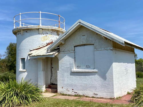
1904 (station established 1882). Inactive since 2007. 7 m (23 ft) round cylindrical brick tower attached to 1-story service building; lighthouse painted white. Lantern removed in 2011. Endangered. This isolated and abandoned lighthouse has been vandalized repeatedly. It was restored during the 1990s but was quickly vandalized again. Dayle Green's 2023 photo is at right, Ali Davoudian has a 2018 photo, Lynne Takacs has a 2021 photo, Wikipedia has an April 2015 photo by Ronald Besdansky, Brett Matthews has a good photo, a January 2008 photo by Matthias Kohrt and Helena Clemens-Kohrt shows the lighthouse in a severely deteriorated condition, Wikipedia's article has a historic photo from 1908, and Google has a satellite view. The condition of this historic lighthouse was recognized as a disgrace and in 2010 the state government set aside A$100,000 for restoration. In February 2011 the Shoalhaven City Council established a citizens' steering committee to guide improvements at the station. Inmates from the South Coast Correctional Centre were put to work clearing the grounds around the lighthouse, and in December 2011 the lantern was airflifted by a Australian Navy helicopter to be restored in the prison's shop. Sadly, in 2013 the council backed away from the project and moved to disband the steering committee. Crown Lands was willing to provide some funding for restoration but only if the Council agreed to assume responsibility for maintenance. In July 2014 the committee formally disbanded, putting an end for now to the restoration project. However, preservationists are maintaining a Facebook page for the continuing effort to save the lighthouse. In 2022 the restored lantern was installed on a replica tower at the Jervis Bay Maritime Museum in Huskisson. Trabas has Boucher's photo of the active light (focal plane 22 m (72 ft); quick-flashing white light), now shown from a mast in front of the historic lighthouse. Located in Culburra Beach on the south side of the entrance to the Shoalhaven River east of Nowra. The lighthouse is accessible by a short hike through the bush; parking is available at the north end of Prince Edward Avenue in Culburra Beach. Site open, tower closed. Operator/site manager: NSW Maritime Authority. . ARLHS AUS-061. Active light: Admiralty K2594; NGA 6500.

Crookhaven Heads Light, Shoalhaven, November 2023
Instagram photo by Dayle Green
* Crookhaven Heads (2) (lantern and replica)
2022. Inactive replica. 1-story concrete tower carrying the restored 1860 lantern of the Crookhaven Heads lighthouse, originally from the Cape St. George lighthouse. Brian Hogan has a 2022 photo, Arkadiusz Kwiatkowski also has a 2022 photo, and Google has a satellite view of the museum. The lantern was restored by inmates of the South Coast Correctional Centre and installed on the replica tower at the Jervis Bay Maritime Museum in Huskisson. Funding was provided by a $200,000 grant from the state government's Create NSW Fund. The museum has a 2023 photo. Site open, tower closed. Owner/site manager: Jervis Bay Maritime Museum.
* Point Perpendicular (1)
1899. Inactive since 1993 (a decorative light is displayed on special occasions). 21 m (70 ft) round cylindrical concrete block tower attached to a 1-story concrete block keeper's house. Entire lighthouse painted white, except the gallery rail is black. The keeper's houses were reported for sale. Neil Rustidge's photo is at right, Phil Whitehouse has a photo, Miriam Grey has a 2022 photo, Wikipedia's article has excellent photos, Oliver Frank has a 2007 photo, Huelse has a historic postcard view, Amanda Ritchard has a closeup street view, and Google has a satellite view. This lighthouse replaced the Cape St. George Lighthouse after it was realized that the proper location of a light for the entry to Jervis Bay was on the north side of the entrance rather than the south side.The Department of Defence restored the lighthouse in 2012, and each year it is briefly relit and opened for tours during International Lighthouse Heritage Weekend (third weekend in August). Located at the end of the Beecroft Peninsula south of Currarong, marking the north side of the entrance to Jervis Bay. Site and tower closed (fenced), but the lighthouse can be viewed at close range. According to the Wikipedia article access is sometimes blocked by the military during gunnery exercises. Tours may be offered occasionally. Owner/site manager: Australian Department of Defence. . ARLHS AUS-137.
* Point Perpendicular (2)
1993 (station established 1899). Active; focal plane 95 m (311 ft); white flash every 10 s. 19 m (62 ft) square cylindrical skeletal tower painted white. Phil Whitehouse's photo shows both lighthouses, Amanda Richard has a closeup street view, and Google has a satellite view. Located adjacent to the historic lighthouse. Site and tower closed (fenced), but the lighthouse can be viewed at close range. Owner/site manager: Australian Department of Defence. Admiralty K2588; NGA 6504.

Point Perpendicular Light, Currarong, April 2019
Instagram photo by Neil Rustidge

Jervis Bay Territory Lighthouse
The Jervis Bay Territory is a small section of New South Wales transferred to federal control in 1915 and administered since then by Commonwealth authorities.
* Cape St. George
1860. Inactive since 1889. Ruins of a round stone tower attached to a stone keeper's house. Chandra Banda has a 2021 photo, Brett Matthews has a good photo, Wikipedia's article has a historic photo, Alex Wolfson has a street view, and Google has a satellite view. Though it was built in the wrong place, the lighthouse served for three decades before being replaced by the Point Perpendicular Light. The original lantern and Fresnel lens were transferred to the Crookhaven Heads lighthouse; the lantern is now displayed on a replica tower at the Jervis Bay Maritime Museum in Huskisson (see above). The park service has stabilized the picturesque ruins against further decay. Located about 3 km (2 mi) south of the southern entrance to Jervis Bay, off Stony Creek Road, a gravel park road, about 16 km (10 mi) southeast of the town of Jervis Bay. Parking provided; it's an easy walk to the lighthouse. Site open, tower closed. Site managers: Wreck Bay Aboriginal Community and Australian Dept. of the Environment (Booderee National Park). . ARLHS AUS-048.

Southern Shoalhaven Council Area Lighthouses
* Warden Head (Ulladulla)
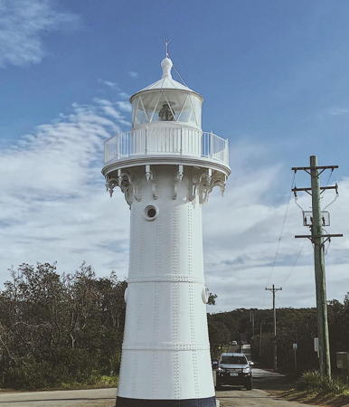
1873 (relocated here in 1879) (Edward O. Moriarty). Active; focal plane 34 m (112) ft; two white flashes every 10 s. 12 m (40 ft) tapered round wrought iron tower with lantern and gallery, painted white. A photo is at right, Trevon Moore has a 2021 photo, Brett Matthews has a fine photo, a 2007 photo is available, Trabas has Boucher's closeup, Wikimedia has several photos, and Google has a street view and a satellite view. Sibling of Wollongong Harbour Light (see above). Originally built on the breakwater at Ulladulla; Wikipedia's article has a historic photo showing the light at its first location. James Barnet had the lighthouse moved to Warden Head in 1889. The keeper's house was relocated in the 1920s to Milton, where it is used as a doctor's office. In 2008 a $65,000 project repainted the lighthouse and carried out some needed structural repairs. In 2018 there was another repainting and a more complete restoration costing $460,000. In 2022 Crown Lands made major site improvements including new viewing platforms, car parking, pathways and landscaping. Located on the headland east of Ulladulla. Accessible by road; parking provided. Site open, tower closed. Operator/site manager: NSW Maritime Authority. . ARLHS AUS-166; Admiralty K2584; NGA 6520.

Warden Head Light, Ulladulla, July 2020
Instagram photo by typnorm
Brush Island
Date unknown. Active; focal plane 48 m (158 ft); white flash every 2.5 s. 4 m (13 ft) white fiberglass or concrete tower. No photo available but Google has a satellite view. Located on a forested island off Murramarang Point about 20 km (13 mi) south of Ulladulla. Accessible only by boat. Site status unknown. Admiralty K2577.8; NGA 6540.

Eurobodalla Shire Lighthouses
* Burrewarra Point
1974. Active; focal plane 62 m (203 ft); four white flashes every 15 s. 10 m (33 ft) elliptical cylindrical white concrete tower; solar-powered lens. No lantern. Vaibhav Patil's photo is at right, Brett Matthews has a good photo, Wikipedia's article has a photo, Trabas has Boucher's photo and Google has a satellite view. Located at the end of Burri Point Road (4WD recommended) south of Rosedale and about 25 km (15 mi) southeast of Bateman's Bay. Site open, tower closed. Operator: NSW Maritime Authority. Site manager: unknown. . ARLHS AUS-016; Admiralty K2577.6; NGA 6556.
** Montague Island
1881 (James Barnet). Active; focal plane 80 m (262 ft); white flash every 7.5 s. 21 m (69 ft) round granite tower with lantern and gallery. Tower unpainted, lantern painted white. The original Fresnel lens, removed in 1986, is on display at the Narooma Lighthouse Museum in Narooma. Two 1-story keeper's houses. Trevor Carter's 2023 photo is at the top of this page, Kelly Spinks has a good photo, the park service has a fine panoramic view, Wikipedia's article has a photo, Wikimedia has many historic photos, Trabas has Boucher's distant view and Google has a street view and a satellite view. Located about 15 km (9 mi) southeast of Narooma, Montague Island is a wildlife reserve famous for its seabirds, fairy penguins, and seals. Access to the island is restricted. Starting in late 2005 Conservation Volunteers Australia opened the keeper's houses for overnight stays by up to 11 people. In 2014 the houses were renovated and the accommodations upgraded. Located at the highest point of the island. Site and tower open to guided tours from Narooma (reservations required). Operator: AMSA. Site manager: NSW National Parks (Barunguba Montague Island Nature Reserve). . ARLHS AUS-110; Admiralty K2576; NGA 6568.
 

Burrewarra Point Light, Rosedale, April 2018
Instagram photo by Vaibhav Patil
 

Bega Valley Shire Lighthouses
* [Twofold Bay (Eden Harbour, Lookout Point) (4?)]
Date unknown (station established 1862). Active; focal plane 39 m (128 ft); white or red light depending on direction, 2 s on, 1 s off. 14 ft (46 ft) white metal mast. Sam Wilson has a street view and Google has a satellite view. A 13.7 m (45 ft) wood tower was built on Lookout Point in 1862; this is a short distant west of the current location. By 1904 a wood tower was listed at the current site. NGA describes a metal framework tower. Located on a steep point off Bramble Street in Eden, marking the north side of the entrance to Twofold Bay and Eden Harbour. Site open, tower closed. Admiralty K2572; NGA 6576.
* [Boyd's Tower]
1847. Never active as a lighthouse but famous as a daybeacon. 23 m (75 ft) square unpainted sandstone tower. A closeup photo is available, Brett Miller has a 2022 photo, Deborah Lopezfreeman has a 2019 photo, and Google has a street view and a satellite view. The tower was built by Benjamin Boyd (1801-1851), a pioneer landowner in the area. It was intended as a lighthouse but was not accepted for that purpose. The tower has damage at the top caused by a lightning strike in the 1860s. The area was incorporated into the Ben Boyd National Park (now Beowa National Park) in 1976. Located on a steep point on the south side of the entrance to Twofold Bay. Accessible by a paved walkway. Site open, tower closed. Site manager: NSW National Parks (Beowa National Park). .
*** Green Cape (1)
1883 (James Barnet). Inactive since 1992. 29 m (95 ft) round concrete tower with lantern and gallery, painted white. Lower section of the tower is square pyramidal, upper section octagonal cylindrical. The original 1st order Fresnel lens is mounted in the lantern. Two 1-story assistant keeper's houses are available for vacation rental. Arkadiusz Kwiatkowski's photo is at right, Laurie Bailey has a 2021 photo, Wikimedia's article has good photos, Don Shearman has a 2007 photo, and Google has a street view and a satellite view of the station. This is Australia's oldest concrete lighthouse. Located on a prominent headland about 40 km (25 mi) southeast of Eden. Site open, tower open to guided tours Thursday through Monday in the summer, also Monday, Thursday and Friday in the winter (reservations recommended). Site manager: NSW National Parks (Beowa National Park and Green Cape Lightstation ). ARLHS AUS-085.
* Green Cape (2)
1992 (station established 1883). Active; 39 m (118 ft); two white flashes every 15 s). 15 m (49 ft) square cylindrical skeletal tower painted white. Trabas has Boucher's photo, Carol Wilson has a 2023 photo, and Google has a satellite view and a closeup street view. Located adjacent to the historic lighthouse. Site open, tower closed. Operator: AMSA. Site manager: NSW National Parks (Ben Boyd National Park). Admiralty K2570; NGA 6588.

Green Cape Light, Eden, February 2023
Google Maps photo by Arkadiusz Kwiatkowski

Information available on lost lighthouses:

Notable faux lighthouses:

Adjoining pages: North: Northern New South Wales | South: Victoria

Return to the Lighthouse Directory index | Ratings key

Posted April 2004; checked and revised February 10, 2024. Lighthouses: 39. Site copyright 2024 Russ Rowlett and the University of North Carolina at Chapel Hill.