Lighthouses of New Zealand: Northeast South Island

New Zealand is an independent island nation in the southwestern corner of the Pacific Ocean. Its location is remote, roughly 1500 km (900 mi) southeast of Australia and 1000 km (600 mi) south of New Caledonia and Fiji. Settled in the 13th Century by a Polynesian people known as the Māori, it was colonized by Great Britain in 1840. It has been part of the British Empire and then the British Commonwealth ever since. It is a Commonwealth realm, recognizing the British monarch as head of state. New Zealand has a population of about 5.1 million.

New Zealand is larger than many Northern Hemisphere residents might suppose: roughly 1600 km (1000 miles) long from north to south, stretching from the subtropical north to the cool temperate south. It includes two large islands, North Island and South Island, with many smaller islands. For local government the country is divided into sixteen regions, including eleven regional council areas and five unitary council areas. The regional council areas are subdivided into districts.This page describes lighthouses of the north and east coasts of South Island, including Nelson City, the unitary council areas of Tasman and Marlborough, and the regional council area of Canterbury.

Most of the coastline of New Zealand is high and scenic. Many of the lighthouses are at remote locations, and lighthouse fans need a good pair of hiking shoes to reach some of them, if they can be reached at all.

Coastal lighthouses are operated and maintained by Maritime New Zealand. Information on most of these lighthouses is readily available on the MNZ web site. Harbor lighthouses, however, are owned and maintained by local harbor authorities, and less information is available for most of them. There is no national lighthouse preservation group, but Heritage New Zealand has acted to preserve several lighthouses after they were deactivated.

Many of the place names in New Zealand are in the Māori language; the Māori phrase for a lighthouse is whare rama or whare tūrama; motu is an island, toka is a rock, and whanga is a harbor.

ARLHS numbers are from the ARLHS World List of Lights. Admiralty numbers are from Volume K of the Admiralty List of Lights & Fog Signals. U.S. NGA light list numbers are from NGA Publication 111.
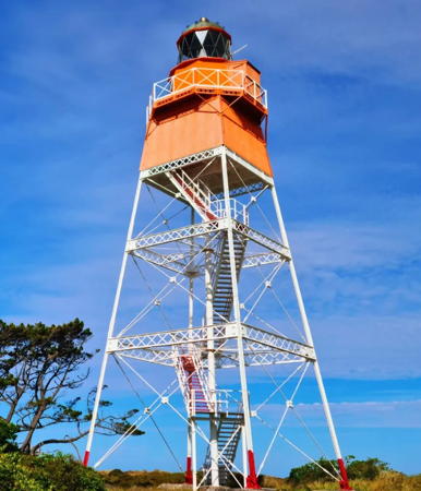

Farewell Spit Light, Tasman, November 2024
Instagram photo by Suss from NZ
General Sources
Maritime New Zealand - Lighthouses
Information available on Maritime New Zealand's lighthouse site.
List of Lights
Official light lists posted by Land Information New Zealand.
Encyclopedia of New Zealand - Lighthouses
An excellent historical account by Helen Beaglehole.
Lighthouses of Foveaux Strait - a History
(pdf file) A 144 page report by Angela Bain, published by the N.Z. Department of Conservation.
New Zealand Lighthouses
Data and photos posted by Kevin Mulcahy of Lighthouses.net.au.
World of Lighthouses - New Zealand
Photos by various photographers available from Lightphotos.net.
Lighthouses in New Zealand
Photos by various photographers available from Wikimedia Commons.
New Zealand Lighthouses
Photos taken in 2017 by Larry Myhre.
Online List of Lights - New Zealand
Photos by various photographers posted by Alexander Trabas. Many photos for South Island are by Michael Boucher or Rainer Arndt.
Leuchttürme.net - Neuseeland
Photos and data posted by Malte Werning.
Leuchttürme Australiens und Ozeaniens auf historischen Postkarten
Historic postcard views posted by Klaus Huelse.
GPSNavigationCharts
Navigation chart information for New Zealand.hh
 

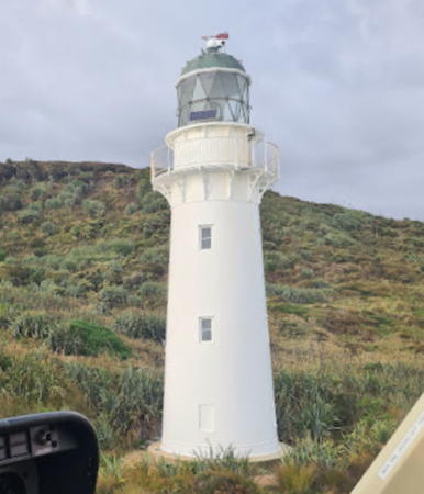
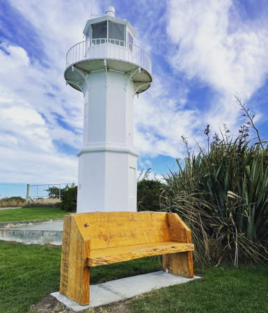
Tuhawaiki Point Light, Timaru, May 2023
Instagram photo by The Upcycle Barn

Tasman and Nelson Lighthouses

The Tasman District and Nelson City are independent regional-level administrative units, but they cooperate in various ways and are described informally as forming the Nelson Tasman Region.

Tasman District Lighthouses
Kahurangi Point
1903. Active; focal plane 46 m (151 ft); two white flashes every 12 s. 18 m (59 ft) round cast iron tower with lantern and gallery, painted white; lantern roof is black. The relatively modern 1-story keeper's house is an overnight shelter for backpackers. Ashton McGill's 2023 photo is at right, Timothy Mora has a 2022 closeup photo, Mulcahy has another MNZ photo, and Google has a satellite view. The tower was prefabricated in New Zealand by Judd's Foundry of Thames. The lighthouse was severely damaged by an earthquake in 1929; it was repaired and returned to service in 1931. Automated in 1960, the lighthouse is now operated on solar power. Located just inside the border of the Tasman District and near the northwestern corner of South Island about 50 km (30 mi) north of Karamea. The surrounding area is rugged and without roads or trails. Accessible by a challenging hike of at least 4 hours along the beach. Site and tower closed. Operator: Maritime New Zealand. Site manager: N.Z. Department of Conservation (Kahurangi National Park). . ARLHS NZL-029; Admiralty K4506; NGA 5640.
Pillar Point (Cape Farewell)
1930. Active; focal plane 166 m (545 ft); white flash every 5 s. 4 m (13 ft) square cylindrical steel tower. Trabas has Arno Siering's photo, Paul Webby has a 2018 photo, Mulcahy has a photo, and Google has a 2019 street view and a satellite view. This modest light is the main landfall light for vessels arriving in New Zealand from the west. Located atop Pillar Point, one of the headlands of Cape Farewell, the northernmost point of South Island. Accessible by a hiking trail from the Farewell Spit Visitor Centre. Site open, and ecotours visit the area; tower closed. Operator/site manager: Maritime New Zealand. ARLHS NZL-040; Admiralty K4180; NGA 4916.
Farewell Spit (Bush End Point) (2)
1897 (station established 1870). Active; focal plane 30 m (98 ft); flash every 15 s, white or red (red is shown for vessels approaching from the north). 27 m (88 ft) square pyramidal steel skeletal tower with lantern, gallery, and enclosed watch room. Lantern and watch room painted orange; tower legs and gallery rail painted white; the lantern dome is gray. The 1-story wood keeper's quarters appears occupied (perhaps by a park ranger). A 2024 photo is at the top of this page, Josephine Tucker has a 2023 photo, Keith Foord has a 2011 photo, Hans de Jong has a photo, Trabas has a photo, and Google has a satellite view. Similar in design to many Canadian lights, this lighthouse is unique in New Zealand. It replaced a 34 m (112 ft) octagonal wood skeletal tower that did not hold up well in the vigorous weather of the strait. The original Fresnel lens, removed in 1999, is on display in one of the service buildings of the station. The sandy Farewell Spit (Onetahua) extends eastward more than 25 km (15 mi) from Cape Farewell, enclosing Golden Bay (Mohua). The area is a critically important bird nesting area, closed to casual visits. Located at Bush End Point near the end of the spit; accessible only by guided ecotours. Site open, tower closed (visitors can climb the stairs but cannot enter the enclosed portion of the lighthouse). Operator: Maritime New Zealand. Site manager: N.Z. Department of Conservation (Farewell Spit and Pūponga Farm Park). . ARLHS NZL-022; Admiralty K4182; NGA 4920.

Kahurangi Point Light, Tasman, May 2023
Google Maps photo by Ashton McGill
[Separation Point (2)]
Date unknown. Active; focal plane 18 m (59 ft); white flash every 8 s. 3 m (10 ft) square white metal cabinet. Google has a street view and a satellite view. Mulcahy has an MNZ photo showing a round metal tower. Located on a sharp promontory at the southern entrance to Golden Bay 26 km (16 mi) due south of the Farewell Spit lighthouse. Accessible by hiking trail. Site open, tower closed. Operator: Maritime New Zealand. Site manager: Abel Tasman National Park. ARLHS NZL-046; Admiralty K4204; NGA 4944.
[Pitt Head]
Date unknown. Active; focal plane 23 m (75 ft); two flashes every 15 s, white or red depending on direction. 3 m (10 ft) post standing next to a square 1-story equipment shelter painted orange with a white vertical stripe. Google has a sea view but the beacon is hard to see in Google's satellite view. The nearby Pitt Head Lookout is a popular destination for hikers. Located on a sharp headland overlooking Golden Bay about 20 km (13 mi) south of Separation Point. Operator: Maritime New Zealand. Site manager: Abel Tasman National Park. Admiralty K4206; NGA 4948.

Nelson City Lighthouses
The oldest city of South Island, Nelson was founded in 1841. Located at the south end of Tasman Bay (Te Tai-o-Aorere) the city has a population of about 55,000.
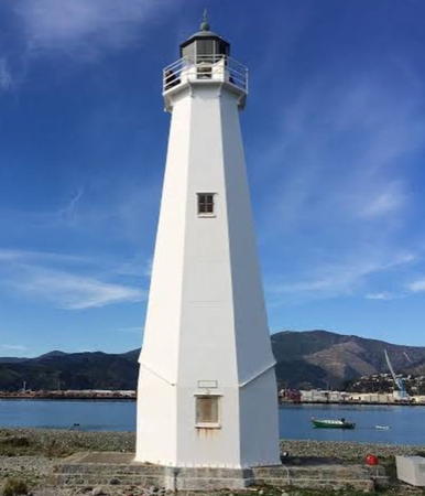
** Nelson (Boulder Bank)
1862. Inactive since 1982. 18 m (60 ft) octagonal cast iron tower with lantern and gallery, painted white; lantern roof is black. Prefabricated in England by Stothart and Pitt of Bath. The keeper's houses were relocated to Nelson in 1916; we do not know if they survive. Matthew Hartley's photo is at right, Murray Neill has a closeup photo, a 2023 photo is available, Wikimedia has a good photo, Huelse has a historic postcard view, and Google has a street view and a satellite view. The lighthouse was retired because it could no longer be seen clearly against the lights of the growing town; prior to deactivation it was New Zealand's oldest active lighthouse. In 2011 the harbor authority proposed a plan to install a decorative light in the tower, the light being directed toward the town and not toward the sea; it's not known if this plan was carried out. Lily Robertson wrote a memoir of her life as a child at the lighthouse in the 1880s; she provided a historic photo of the light station. Located across from the Nelson waterfront on Boulder Bank, a long, rocky barrier beach sheltering the harbor of Nelson, at the south end of Tasman Bay. Nearly all access is by boat; it is a strenuous hike of 30 km (19 mi) round trip to reach the lighthouse by walking the length of the bank. The lighthouse is easily visible from the Nelson waterfront. Site open, tower open by arrangement (visitors can borrow the key to the tower from the Nelson Council Office). Owner: Heritage New Zealand. Site manager: N.Z. Department of Conservation (Boulder Bank Scenic Reserve). . ARLHS NZL-004.
[Nelson Landfall (2)]
Date unknown. Active; focal point 22 m (72 ft); two flashes every 12 s, white or red depending on direction. 19 m (59 ft) mast. The light is in the lower right corner of an aerial view of the harbor and Google has a satellite view. NGA lists a skeletal tower. Located on the Nelson waterfront. Site status unknown. Operator: Port Nelson. Admiralty K4224; NGA 4996.
* [Schnapper Point]
Date unknown. Active; focal point 13 m (43 ft); four flashes, separated by 3.5 s, every 20 s, white or red depending on direction. 11 m (36 ft) steel mast. David Rowley has a distant street view of the light in action and Google has a closeup street view and a satellite view. Located at the end of Boulder Bank Drive, which is also the base of the Boulder Bank, about 15 km (9 mi) northeast of Port Nelson. Site open, tower closed. Operator: Port Nelson. Site manager: N.Z. Department of Conservation (Boulder Bank Scenic Reserve). Admiralty K4222; NGA 5020.

Boulder Bank Light, Nelson, September 2019
Instagram photo by Matthew Hartley

Marlborough Region Lighthouses

French Pass Lighthouses
French Pass (Te Aumiti), the channel between D'Urville Island (Rangitoto ki te Tonga) and the mainland, is a narrow passage used by inter-island shipping between Nelson on the South Island and Wellington on the North Island. Strong tidal currents race through the strait.

Okuri Point
Date unknown. Active; focal point 34 m (112 ft); flash every 4 s, white or red depending on direction. 4 m (13 ft) short mast atop a round white metal tower. Mulcahy has a photo and Google has a satellite view. Located on a steep promontory at the southern entrance to the French Pass channel. Site status unknown. Operator: Maritime New Zealand. ARLHS NZL-083; Admiralty K4234; NGA 5024.
* French Pass (Channel Point)
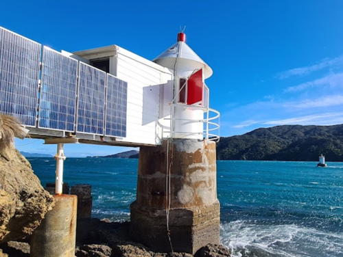
1884. Active; focal plane 3 m (10 ft); continuous light, red or white depending on direction of approach. 5 m (17 ft) round lantern, painted white, mounted on a round stone pedestal. Red filters on adjustable panels are used to set the sector boundaries precisely. A wooden bridge connects the tower to the shore. Ashton McGill has the 2023 photo seen at right, Trabas has Boucher's photo, Mulcahy has a photo, this light is on the right of Wikipedia's photo of the pass, Bob van Winden has a similar view from the nearby French Pass Lookout, a 2022 drone view is available, Huelse has a historic postcard view, and Google has a satellite view. This tiny lighthouse, built to mark the difficult channel, was tended by a keeper until 1967. Located on the mainland (south) shore of the pass. Site status unknown, but the village of French Pass can be reached by road from NZ 6 at Rai Valley, east of Nelson. Operator/site manager: Maritime New Zealand. . ARLHS NZL-024; Admiralty K4238; NGA List 5028.
French Pass Reef
1882 (there was an unlit beacon here from the 1860s). Active; focal plane 5 m (16 ft); white flash every 1.5 s. 5 m (16 ft) round cylindrical tower, painted white, mounted on a stone pedestal. Stefan Philippsen has a photo, Trabas has Boucher's photo, this light is on the right in McGill's photo (at right) and on the left of Wikipedia's photo of the pass, Bob van Winden has a similar view from the nearby French Pass Lookout, a 2022 drone view also shows the severe tidal bore that occurs frequently in the pass, and Google has an indistinct satellite view. The French Pass channel is between this light and the previous one. Tended by the French Pass keeper until 1967. Located on a reef in the pass. Accessible only by boat. Site and tower closed. Operator/site manager: Maritime New Zealand. ARLHS NZL-069; Admiralty K4240; NGA 5032.

French Pass Light, French Pass, July 2023
Google Maps photo by Ashton McGill

Cook Strait Lighthouses
Stephens Island
1894. Active; focal plane 183 m (600 ft); white flash every 6 s. 15 m (50 ft) round cast iron tower with lantern and gallery, painted white; lantern roof is gray. A photo is at right, a closeup and a photo of the light in action are available, and Google has a satellite view. New Zealand's highest light marks the northwestern entrance to Cook Strait; it has a range of more than 50 km (30 mi). Stephen's Island, also known by its Māori name Takapourewa, is the home of several very rare species of wildlife including the tuatara (a lizard-like reptile that is the only living member of the Rhynchocephalia, a group common during the age of dinosaurs). Located at the northern end of the steep-sided island, northeast of the much larger D'Urville Island. Inaccessible to the public. Site and tower closed (ecological reserve); special permits are required. Operator: Maritime New Zealand. Site Manager: N.Z. Department of Conservation (Stephens Island Nature Reserve). ARLHS NZL-048; Admiralty K4236; NGA 5044.
Cape Jackson Rock
1903. Active; focal plane 15 m (49 ft); white flash every 4 s. 15 m (49 ft) 16-sided pyramidal concrete tower. A slide show has a closeup photo (second of the five photos), Edwin Troost has a view from the mainland, a view from the sea is available, and Google has an indistinct satellite view. Cape Jackson is a slender, snake-like, rocky peninsula jutting into Cook Strait about 50 km (30 mi) east of Stephens Island. In 2001 the official Cape Jackson Light was moved to the small modern tower at the tip of the peninsula (next entry) but the old lighthouse also remains in service. The Russian cruise ship Mikhail Lermentov wrecked here in 1986 trying to pass between the lighthouse and the mainland. Maritime New Zealand repaired and upgraded the light in 2010. Located on a bare rock about 650 m (0.4 mi) off the end of the peninsula. Inaccessible, but there are good views from the end of the Outer Queen Charlotte Track, a two-day walk from Ship Cove. (The land is privately owned and access is controlled to protect the environment; reservation is required for a hiking permit.) Site and tower closed. Operator: Maritime New Zealand (?). Site manager: Queen Charlotte Wilderness Park. ARLHS NZL-070; Admiralty K4244.5; NGA 5089.

Stephens Island Light, Cook Strait
Maritime New Zealand photo
Cape Jackson
Date unknown. Active; focal plane 87 m (285 ft); three white flashes every 20 s. 4 m (13 ft) square white metal tower. Steve Bittinger has a 2018 photo and Google has a satellite view. Located at the end of the Outer Queen Charlotte Track. Site open, tower closed. Operator: Maritime New Zealand. Admiralty K4244; NGA 5088.
Brothers Island (The Brothers)
1877. Active; focal plane 79 m (259 ft); white flash every 10 s (a red flash is shown in two sectors). 12. 5 m (41 ft) hexagonal wood tower with lantern and gallery; external wood bracing helps steady the tower against fierce winds. Tower painted white, lantern black. An MNZ photo of the station is at right, Mulcahy has an MSA closeup photo, another closeup is available, Trabas has Arndt's photo, Wikimedia has a view from the sea, and Google has a satellite view. This lighthouse replaced the Mana Island Light, which was moved to Cape Egmont (see the North Island page). It helps guide vessels through the narrowest passage of the strait, west of Wellington. In 2001 the lighthouse was solarized, in part so that toxic substances from storage batteries would not endanger the wildlife. The island is closed to the public. Located atop a rocky island in Cook Strait west of Wellington. Site and tower closed; the light is visible distantly from Cook Strait ferries. Operator: Maritime New Zealand. Site Manager: N.Z. Department of Conservation (The Brothers Sanctuary). ARLHS NZL-051; Admiralty K4246; NGA 5176.

Queen Charlotte Sound and Cape Campbell Lighthouses
Queen Charlotte Sound (Tōtaranui) is the largest and easternmost of the Marlborough Sounds, an intricate network of drowned valleys extending south from D'Urville Island. The sound has a broad entrance between Cape Jackson and The Brothers but the commercially useful entrance is the narrow Tory Channel (Kura Te Au), the entrance farthest south and thus closest to Wellington, on the south side of Arapaoa Island.

Farnham Point
Date unknown. Active; focal plane 6 m (20 ft); red, white or green light depending on direction, 2 s on, 8 s off. 6 m (20 ft) square cylindrical white metal tower. Trabas has Arndt's photo and Google has a distant satellite view. The light guides vessels entering Queen Charlotte Sound from the north. Located at the tip of a sharp promontory inside the sound. Accessible only by boat. Site open, tower closed. Operator: Port Marlborough. Admiralty K4249.5; NGA 5095.

Brothers Island Light, Cook Strait
Maritime New Zealand photo
* Okukari Bay (Tory Channel, Whekenui) Range Front
1881. Active; focal plane 7.5 m (25 ft); quick-flashing white light. 6.5 m (21 ft) square pyramidal wood tower, painted white with an orange vertical stripe on the front face. Trabas has Boucher's photo, a historical article has a photo of both range lights, and Google has a satellite view. This range guides interisland ferries sailing from Wellington to Picton through the narrow Tory Channel as they leave Cook Strait. The two lights are the only examples of their type still in use. Located on the grounds of a resort on the east side of Okukari Bay. Site open, tower closed. Operator: Port Marlborough. Site manager: Arapawa Homestead. Admiralty K4264; NGA 5168.
* Okukari Bay (Tory Channel, Whekenui) Range Rear
1881. Active; focal plane 27 m (89 ft); white light, 1 s on, 1 s off. 6.5 m (21 ft) square pyramidal wood tower, painted white with an orange vertical stripe on the front face. Trabas has Boucher's photo, a historical article has a photo of both range lights, and Google has a satellite view. This light is identical to the front light. Located 130 m (427 ft) northwest of the front light. Site open, tower closed. Operator: Port Marlborough. Site manager: Arapawa Homestead. Admiralty K4264.1; NGA 5172.
[Dieffenbach Point]
Date unknown. Active; focal plane 12 m (39 ft); white flash every 3 s. 3 m (10 ft) round white cabinet enclosed with a white picket fence. Trabas has Thomas Philipp's photo, a distant view from the sea is available, and Google has a satellite view. Interisland ferries make a sharp turn around this point on their course approaching or leaving Picton. Located at the tip of a sharp promontory on the south side of Queen Charlotte Sound. Site open, tower closed. Operator: Port Marlborough. Admiralty K4252; NGA 5100.
[Tory Channel West Head]
Date unknown. Active; focal plane 46 m (151 ft); two flashes, one long and one short, white or red depending on direction, every 10 s. 4 m (13 ft) square cylindrical steel tower. Trabas has Boucher's photo and Google has a satellite view. Located on a sharp promontory on the west (really south) side of the entrance to the Tory Channel. Accessible only by boat. Site status unknown. Operator: Port Marlborough. Admiralty K4262; NGA 5164.
* Cape Campbell (2)
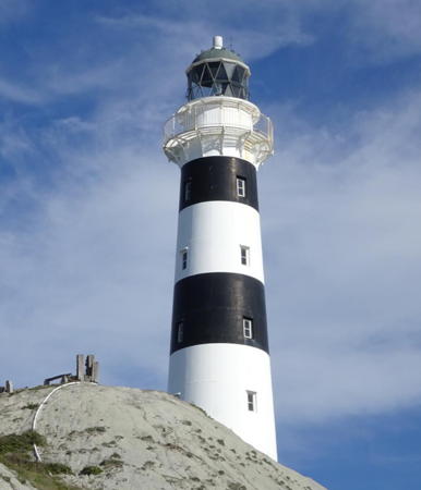
1905 (station established 1870). Active; focal plane 47 m (155 ft); white flash every 15 s. 22 m (73 ft) round cast iron tower with lantern and gallery, painted with black and white horizontal bands. A 2019 photo by Matthew Hartley is at right, Trabas has Tom Chisholm's photo, Rebecca Peihopa has a 2024 closeup, Shannon Radcliffe has a 2018 closeup photo, Felipe Castro also has a 2018 photo, David Gilmore has a 2017 photo, another 2017 photo is available, and Google has a satellite view. This is one of only a few New Zealand lighthouses with colored bands; here the bands help distinguish the tower from the white bluff on which it stands. The lighthouse marks the southeastern entrance to Cook Strait. This is the lighthouse featured in the 2016 film The Light Between Oceans (although the plot of that movie is set in Australia). The lighthouse was restored in 2020-21; Justin Broom has a February 2021 photo of this work in progress. Located on the cape about 30 miles southeast of Blenheim; accessible by a short hike from the parking area at the end of Marfells Beach Road, off NZ 1 south of Lake Grassmere. Site open, tower closed. Operator/site manager: Maritime New Zealand. . ARLHS NZL-006; Admiralty K4274; NGA 5188.

Cape Campbell Light, Marlborough, September 2019
Instagram photo by Matthew Hartley

Canterbury Region (East Coast) Lighthouses

Kaikōura District Lighthouse
* Point Kean (Kaikōura Peninsula)
Date unknown. Active; focal plane 41 m (135 ft); two white flashes every 15 s. 4 m (13 ft) round lantern mounted on a square concrete pad. Lantern painted yellow. Trabas has Boucher's photo (note that modern LED lens atop the lantern), Mulcahy has Davina King's photo, Jens Radtke has another photo, and Google has a satellite view. The light is located in a park, the Kaikōura Recreation Reserve. Located on the tip of the Kaikoura Peninsula, a prominent headland just south of the town of Kaikoura and about 175 km (110 mi) north of Christchurch. Accessible by a short walk uphill from the parking area at the tip of the peninsula. Site open, lantern fenced. Operator: Maritime New Zealand. Site manager: N.Z. Department of Conservation (Kaikōura Peninsula Walkway). Admiralty K4275; NGA 5192.

Hurunui District Lighthouse
* Point Gibson (Port Robinson)
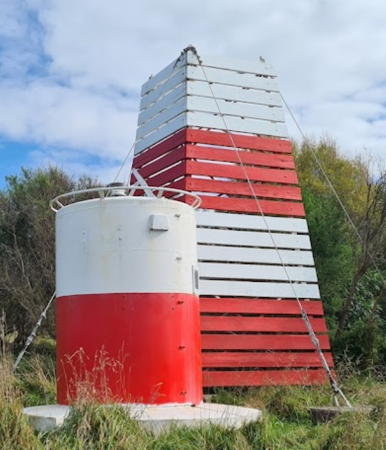
1948. Active; focal plane 76 m (249 ft); white flash every 10 s. 3 m (13 ft) round metal tower painted with a white band above a red band. A 2022 photo is at right, Trabas has Boucher's 2017 photo, Jonathan Corr has a 2021 photo, and Google has a satellite view. Boucher's photo shows that a 6 m (20 ft) square wood daybeacon with slatted sides painted with red and white hrizontal bands has been built behind the light. Located atop a bluff off the end of Manuka Bay Road in Port Robinson, east of Domett. Site open, tower closed. Operator: Maritime New Zealand. Admiralty K4279; NGA 5212.

Christchurch City: Lyttelton Area Lighthouses
Christchurch is the largest city of South Island, having a population of about 400,000. The city and surrounding area were damaged heavily by earthquakes in September 2010 and February 2011. The nearby town of Lyttelton is the seaport associated with Christchurch.

#Godley Head (2)
1940 (?) (relocated lantern of the original 1865 lighthouse). Inactive since the 2011 earthquake. This was (and is) a 6 m (20 ft) octagonal lantern, painted white with a gray roof. Adjoining 1-story equipment building painted white with a red roof. A photo is available and Google has a satellite view of the location. Huelse has a historic postcard view of the original lighthouse, a round stone tower located atop the bluff. That lighthouse was demolished at the start of World War II because it interfered with the line of fire of coastal defense artillery. The original lantern was relocated to Puysegur Point (see below). A blogger has a full account of the history of the lighthouse. After the earthquakes of 2010-11 the 1940 lantern was described as clinging to the cliff "by its toenails." In July 2013 the lighthouse was lifted by helicopter and flown to a Department of Conservation facility, supposedly to be stored awaiting restoration at some undefined future time. However, in early 2020 Alice and Andreas Schuldt found the window frame of the lantern without the dome displayed on the ground at the Godley Head Campground. The fog signal building remains on the cliff, although the foghorn itself fell during the earthquake. Formerly located on a headland at the entrance to Lyttelton Harbour about 8 km (5 mi) east of Lyttelton and 20 km (13 mi) southeast of Christchurch. Site closed. Site and tower closed. Site manager: N.Z. Department of Conservation (Godley Head Recreation Area). ARLHS NZL-025.

Point Gibson Light, Port Robinson, April 2022
Google Maps photo by Gretchen H
* [Godley Head (3)]
2015 (station established 1865). Active; focal plane 127 m (417 ft); white light, 2 s on, 4 s off, 2 s on, 4 s off, 2 s on, 12 s off. 4 m (13 ft) post carrying a modern LED light package. Following the earthquakes Maritime New Zealand announced that the Godley Head Light would not be replaced. Protests from mariners led to a reversal of this decision and the new light was installed in December 2015. Deon Swiggs has a street view and the small light is seen in Google's satellite view. Located atop the bluff in the World War II battery. Site open. Operator: Lyttelton Port Company. Admiralty K4286; NGA 5232.
Sticking Point Breakwater
Date unknown. Active; focal plane 8 m (26 ft); two green flashes every 5 s. 8 m (26 ft) square pyramidal skeletal tower painted white. Trabas has Boucher's photo and Google has a satellite view. Located on a breakwater pier at the container terminal on the east side of Lyttelton Harbour. Site status unknown. Admiralty K4293; NGA 5252.
Lyttelton Harbour (Gladstone Quay) (1)
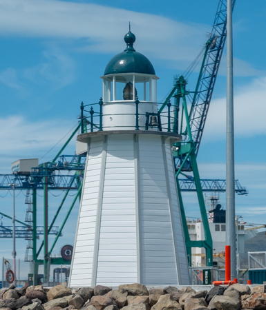
1878 (?). Inactive since 2011. 6 m (20 ft) octagonal wood tower with lantern and gallery. Lighthouse painted white, lantern dome and gallery rail dark green. Michal Klajban's 2021 photo is at right and Google has a satellite view. Prior to the earthquakes Paige Valentine took a 2008 closeup and Phillip Capper has a 2005 view from outside the harbor. The two earthquakes partially collapsed the quay and left the lighthouse with a severe lean; the Port Corporation has a photo that shows this lean. The pier was replaced by a new cruise ship pier while the lighthouse was removed to storage. The lighthouse returned when the new pier was completed in November 2020. In the meantime the active light (focal plane 6 m (20 ft); quick green flash every 1 s) was placed on a slender mast; Trabas has Boucher's 2017 photo. Located at the end of the historic Gladstone Quay on the east side of the entrance to Lyttelton harbor. Acessible by walking the quay. Site open, tower closed. Operator: Lyttelton Port Corporation. Admiralty K4300; NGA 5272.
Shag Reef Range Front (4?)
Around 2018. Active; focal plane 10 m (33 ft); continuous light, white red or green depending on direction; also a quick-flashing white light at a focal plane of 8 m (26 ft). 10 m (33 ft) white tower. Graeme Anderson has a distant 2019 street view, Eric Huang has a 2024 aerial view showing both range lights to the left of center, and Google has a satellite view. Trabas has Boucher's 2017 photo showing a 10 m round white tower, mounted on a hexagonal wood platform supported by piles. That beacon replaced a 7 m (23 ft) round concrete tower with gallery. The range guides vessels on their approach to Lyttelton. Located about 500 m (0.3 mi) south of the inner harbor entra. nce. Accessible only by boat, but there are good views from shore. Site open, tower closed. Operator/site manager: Lyttelton Port Corporation. Admiralty K4290; NGA 5256.
Shag Reef Range Rear (4?)
Around 2018. Active; focal plane 18 m (59 ft); white light, 2 s on, 2 s off. 18 m (59 ft) round red tower. Graeme Anderson has a distant 2019 street view, and Google has a satellite view. Trabas has Boucher's 2017 photo showing a post, mounted on a round concrete pier and carrying a rectangular daymark colored in a yellow and orange checkerboard pattern. Michael Krommydas has a distant 2011 view from shore of an earlier beacon. Located on a rocky reef, 963 m (0.6 mi) west of the front light. Accessible only by boat, but there are good views from shore. Site open, tower closed. Operator/site manager: Lyttelton Port Corporation. Admiralty K4290.1; NGA 5260.

Lyttelton Harbour Light, Lyttelton, October 2021
Wikimedia Creative Commons photo by Michal Klajban

Christchurch City: Banks Peninsula (Akaroa Area) Lighthouses
The rounded Banks Peninsula just south of Christchurch is a a deeply eroded area, the remains of two extinct volcanos. It is cut by deep drowned valleys, the largest being Akaroa Harbour on the south side. On the east side of the Harbour Akaroa is a resort town of about 800 permanent residents, located 84 km (52 mi) southeast of downtown Christchurch.

Steep Head
Date unknown. Active; focal plane 156 m (512 ft); white flash every 5 s. 4 m (13 ft) round lantern mounted on a concrete pad. Lantern painted white. Mulcahy has a photo and Google has a satellite view. Located atop a vertical cliff at the eastern tip of the rugged Banks Peninsula. Site status unknown. Operator: Maritime New Zealand. ARLHS NZL-086; Admiralty K4310; NGA 5280.
Akaroa Head (2)
1980 (station established 1880). Active; focal plane 68 m (223 ft); white flash every 10 s. 3 m (10 ft) round white fiberglass tower. Mulcahy has a photo, Trabas has Boucher's photo, Yuli Yana has a 2022 photo, and Bing has a satellite view. Located at the east side of the entrance to Akaroa Harbour. Site status unknown. ARLHS NZL-001H; Admiralty K4314; NGA 5284.
** Akaroa Head (1) (relocated)
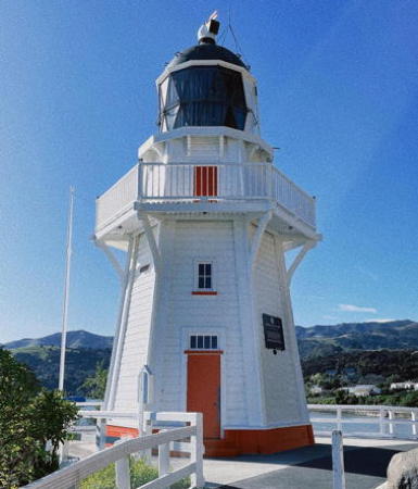
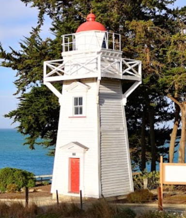
1880. Inactive since 1980 (sometimes lit on holidays and special occasions; charted as a landmark). Approx. 12 m (40 ft) hexagonal wood tower with lantern and gallery, painted white with red trim; lantern painted black. Original Fresnel lens. A 2023 photo is at right, Bernard Snagg has a 2011 photo, Adrian Tritschler has a good photo, Myhre has a photo, a more distant view shows the setting of the lighthouse, and Google has a street view and a satellite view. The lighthouse was originally located at the entrance to Akaroa Harbour, on the southeast corner of the Banks Peninsula. The lighthouse was relocated (in three sections) and is now a tourist attraction on the Akaroa waterfront. The Akaroa Lighthouse Preservation Society was formed to save the lighthouse and now works for its preservation. The Akaroa area escaped serious damage during the earthquakes. In 2020 Christchurch City Council provided half of the $9744 needed to restore and conserve the historic machinery inside the lighthiuse. Sarah und David Rummel have an October 2023 photo showing the lighthouse fully wrapped during restoration. Located at Cemetery Point, Beach Road, Akaroa, about 65 km (40 mi) southeast of Christchurch. Limited parking available. Site open; tower open 11 am to 2 pm on Sundays and days when a cruise ship is in port. Owner: Akaroa Civic Trust. Site manager: Akaroa Lighthouse Preservation Society . ARLHS NZL-001M.

Akaroa Head Light, Akaroa, August 2023
ex-Instagram photo
by snowsn0wflake

Timaru District Lighthouses
Timaru is a port town of about 30,000 residents located 157 km (98 mi) southwest of Christchurch.

*
Timaru Harbour (Blackett's Lighthouse) (relocated)
1878 (John Blackett). Inactive since 1970 (charted as a daybeacon). Approx. 9 m (30 ft) square pyramidal wood tower with lantern and gallery, painted white with red trim; lantern roof is red. A photo is at right, Mulcahy has a photo and Trabas has a photo by Capt. Theo Hinrichs. Originally located on a small island in Timaru Harbour, it was relocated in 1980 to Maori Park on the Timaru waterfront. In 2010 this location was the proposed site for the Caroline Bay Aquatic Centre, so in November 2010 the lighthouse was moved a second time to a site atop a cliff overlooking the bay at the end of Benvenue Avenue. Francis Vallance has a photo of the refurbished lighthouse at its new home, Vanessa Lidgett has a 2022 photo, and Google has a street view and a satellite view of the lighthouse at its new location. On the right side of the street view is the Benvenue Cliff Range Middle Light (Admiralty K4328.1, NGA 5324), a post light with a triangular daymark. Site open, tower closed. Owner: Heritage New Zealand. Site manager: Timaru District Council. . ARLHS NZL-052.
* Timaru War Memorial
Date unknown. Active; focal plane 44 m (144 ft); continuous white light. Mast atop a square memorial clock tower rising from the Timaru District Council building. Trabas has Darlene Chisholm's photo, Marley Strummer has a photo, and Google has a street view and a satellite view. Located on King George Place in downtown Timaru. Site open, tower closed. Operator: PrimePort Timaru. Admiralty K4331; NGA 5304.
* Tuhawaiki Point (Jack's Point)
1903 (relocated 1866 lighthouse). Active; focal plane 29 m (95 ft); white light, 2 s on, 8 s off. 9 m (30 ft) octagonal cylindrical cast iron tower with lantern and gallery; 250 mm lens. Entire lighthouse painted white. A 2023 photo is at the top of this page, Roger Farmer has a 2017 photo, Jodie MacDonald has a 2017 photo, Valerius Lucero has a nice 2018 view of the lighthouse, Trabas has Tom Chisholm's photo, and Google has a satellite view. This prefabricated lighthouse was installed in 1866 at Somes (Matiu) Island in Wellington Harbour, North Island. Replaced there in 1900 by a larger structure, it was briefly stored and then reinstalled here in 1903 by the Timaru Harbour Board. The point is named for a Maori chief, Hone (Jack) Tuhawaiki. The lighthouse is accessible by the Jack's Point Track, a biking and walking trail completed in May 2015. Located about 1 km (0.6 mi) north of the end of Ellis Road off NZ 1 on the south side of Timaru. Site open, tower closed. Operator/site manager: Maritime New Zealand. . ARLHS NZL-028; Admiralty K4340; NGA 5344.

Timaru Harbour Light, Timaru, January 2020
Google Maps photo by Fo

Information available on lost lighthouses:

Notable faux lighthouses:

Adjoining page: North: Southern North Island | South: Southwest South Island

Return to the Lighthouse Directory index | Ratings key

Posted April 2, 2004. Checked and revised December 24, 2024. Lighthouses: 27. Site copyright 2024 Russ Rowlett and the University of North Carolina at Chapel Hill.