Lighthouses of the Philippines: Northwest Luzon

The Republic of the Philippines (Republika ng Pilipinas in Filipino) includes more than 7600 islands stretching over 1750 km (1100 mi) of the western Pacific and separating the Philippine Sea on the east from the South China Sea on the west. The largest islands are Luzon at the northern end of the country and Mindanao at the southern end. As of 2020 the population of the country was about 109 million.

The archipelago was a Spanish colony until the Spanish-American War of 1898 brought the islands under U.S. administration. Japan occupied the islands during World War II (1942-45) and the country became independent shortly thereafter (1946).

The country is divided into 17 regions and subdivided into 81 provinces. Luzon dominates the northern half of the Philippines and includes seven of the regions. This page describes lighthouses of northwestern Luzon, including Zambales Province in the Central Luzon Region and the four provinces of the Ilocos Region.

Filipino and English are official languages in the Philippines. Filipino is a standardized version of the Tagalog language spoken in the Manila area. In Filipino a lighthouses is called a parola; an island is an isla or pulo. Many English maritime terms have been adopted into Filipino, including cape, bay, and port, and the names of historic lighthouses are often retained in their Spanish forms.

Lighthouses in the Philippines are maintained by the Marine Safety Services Command of the Philippine Coast Guard (PCG). Notices to Mariners are posted by the National Mapping and Resource Information Agency (NAMRIA).

ARLHS numbers are from the ARLHS World List of Lights. PCG numbers are the Philippines Light List numbers, where known. Admiralty numbers are from volume F of the Admiralty List of Lights & Fog Signals. U.S. NGA List numbers are from Publication 112.

General Sources
Lighthouses in the Philippines
Photos and observations in blog entries by Loyd Martinez.
Lighthouses in the Philippines
Wikipedia article, with links to articles on several of the individual lighthouses.
Spanish Lighthouses of the Philippines
The Directory's own list of the Spanish light stations, with notes on their current status.
Lighthouses in the Philippines
Photos by various photographers available from Wikimedia.
World of Lighthouses - Philippines
Photos by various photographers available from Lightphotos.net.
Online List of Lights - Philippines
Photos by various photographers posted by Alexander Trabas.
NAMRIA- Notices to Mariners
Monthly notices archived since 2013.
Leuchttürme Asiens auf historischen Postkarten
Historic postcard images posted by Klaus Huelse.
Navigational chart information for the Philippines.
Navionics Charts
Navigational chart information for the Philippines.


Cape Bojeador Light, Ilocos Norte, August 2014
Flickr Creative Commons photo by Ilocos Norte Tourism

Central Luzon Region West Coast Lighthouses

Zambales Province Lighthouses
** Subic Bay Lighthouse Marina
2006. Active (privately maintained and unofficial; charted as a landmark); focal plane about 31 m (102 ft); two white flashes every 8 s. 27 m (89 ft) octagonal pyramidal tower with lantern and gallery. Lighthouse painted white with red trim, lantern red. Grisel Garcia has a photo, John Willy Uy has a closeup, Ryan Parker has a street view from the beach, and Google has a satellite view. This lighthouse was built as part of a large marina development. There is a bar in the lower level, and the second floor has an observation deck. The owners applied for official recognition for the light but apparently it was not granted. Located about 1.5 km (1 mi) southeast of Kalaklan Point, on the southwest corner of the Subic Bay Free Port, which has been developed on part of the grounds of the former U.S. Navy base. Site open, first and second floors of the tower open. Owner/site manager: Lighthouse Marina Resort.
* Kalaklan Point (Subic Sector) (2)
2007 (station establishment date unknown). Active; focal plane 23.5 m (77 ft); continuous light, white, red or green depending on direction. Approx. 15 m (49 ft) concrete post, mounted on a 1-story equipment shelter and carrying a large lantern structure. Entire lighthouse is white. Kristina Ramirez has a 2017 photo, Elvin Prado has a 2017 photo, and Google has a street view and a satellite view. This is a leading light for vessels approaching the Subic Bay naval harbor. The original lighthouse was a 10 m (33 ft) concrete tower with lantern and several buttresses at the base, painted white. Located on a promontory north of the entrance to the naval harbor, south of Olongapo. Site open, tower closed. . ARLHS PHI-115; Admiralty F2675; NGA 14376.
Mayanga Island
Date unknown. Active; focal plane about 40 m (131 ft); white flash every 5 s. Approx. 15 m (49 ft) white concrete tower, flared at the top and bottom. Nemesio Pontevidra has a 2018 photo and a drone view is available and Google has an indistinct satellite view. International light lists have this light with a green flash every 6 s; NGA misspells the name "Mayagna." Located on an islet in the northern end of Subic Bay about 4 km (2.5 mi) northwest of Kalakhan Point. Accessible only by boat. Site status unknown. Admiralty F2676; NGA 14377.
Sueste Point (Subic Bay) (1)
1905. Inactive. 9 m (30 ft) cylindrical cast iron tower; lantern removed. This is one of the French tourelles purchased by the Spanish government but it was not activated until the U.S. administration took control. Endangered: the historic lighthouse is in very poor condition and the keeper's house is in ruins. Thanks to Jun Avecilla for the photo at right. Located on a headland at the west side of the entrance to Subic Bay. Accessible only by boat. Site believed to be open, tower closed.
Sueste Point (Subic Bay) (2)
Date unknown (station established 1905). Active; focal plane 63 m (207 ft); white flash every 5 s. 9 m (30 ft) round hourglass-shaped white fiberglass tower. Jun Avecilla's photo is at right, Ghiezhel Cumigad has a very distant view, and Google has a satellite view. Located on a headland at the west side of the entrance to Subic Bay. Accessible only by boat. Site believed to be open, tower closed. ARLHS PHI-059; PCG-0039; Admiralty F2673; NGA 14364.
Sueste Point Lighthouses
Old and New Sueste Point Lights, Zambales, July 2007
photo copyright Jun Avecilla; used by permission
Capones
1890 (Spanish). Active; focal plane 75 m (245 ft); three white flashes every 15 s. 17 m (56 ft) square cylindrical brick tower, with lantern and gallery, attached to a 1-story brick keeper's house. Tower painted white with red trim. The original 1st order Fresnel lens and lantern have been replaced with a Japanese aluminum lantern and a modern solar-powered light. The keeper's houses and other buildings are in a ruined condition. Jazz Ramiro's photo is at right, Martinez has a page for the light station, Bing Ramos has a March 2008 photo, Teresa Dosado's 2010 photo shows visitors on the gallery, Jerome Alano has a closeup, and Google has a satellite view. The lighthouse traditionally marks the beginning of the northern approach to Subic and Manila Bays. In March 2004 the Philippines chapter of the Environmental Protection of Asia Foundation proposed that the island be set aside as a marine sanctuary and the light station restored by the Foundation as a showcase for its programs. It does not appear that anything has come of this proposal. The light tower has been restored and repainted, as seen in Ramiro's photo, but nothing has been done to restore or rebuild the keeper's house. Located on an island off the coast of Zambales province about 15 km (9 mi) north of the entrance to Subic Bay. Accessible only by boat. Site open, tower closed. . ARLHS PHI-018; PCG-0038; Admiralty F2680; NGA 14380.
Botolan
Date unknown. Active; focal plane unknown; three white flashes every 15 s. Approx. 10 m (33 ft) round barbell-shaped white fiberglass tower. Jovan Leano has a drone view and Google has an indistinct satellite view. Located about 5 km (3 mi) south of Botolan. Site status unknown. Admiralty F2677; NGA 14381.
Palauig Point
Date unknown. Active; focal plane 27 m (89 ft); two white flashes every 10 s. 9 m (30 ft) "white metal framework tower," according to NGA. The top of the light is seen in a 2015 Google street view and the light is between the road and the red-roofed house in Google's satellite view. Located on heights above Palauig. Site status unknown. Admiralty F2682; NGA 14384.
Capones Light
Capones Light, Zambales, February 2007
photo copyright Jazz Ramiro; used by permission
Hermana Mayor Island (2)
Date unknown (station established 1914). Active; focal plane 48 m (157 ft); three white flashes every 5 s. 9 m (30 ft) round white concrete tower with gallery. Keeper's house in unknown condition. No photo available but Google has a satellite view. This is a landfall light for the city of Santa Cruz in northern Zambales. The original light was on a wood skeletal tower of the same height. Located on the highest point of the island, in Dasol Bay about 13 km (8 mi) due west of Santa Cruz. Site status unknown. ARLHS PHI-028; PCG-0469; Admiralty F2684; NGA 14388.

Ilocos Region (Northwest Coast) Lighthouses

Pangasinan Province (Southern Lingayen Gulf) Lighthouses
Cabaongan
Date unknown. Active; focal plane 23 m (75 ft); three white flashes every 15 s. 14 m (46 ft) white barbell-shaped fiberglass tower. A view from the beach (2/3 the way down the page) is available but the photographer was unable to find a way from the beach to the lighthouse. Trees hide the light in Google's satellite view. Located on Adette's Cliff, a bluff between the villages of Cabaongan and Baruan. Site status unknown. PCG-0034; Admiralty F2686; NGA 14390.
* Agno (Sabangan Point, Rena Point)
Date unknown (station established before 1920). Active; focal plane 26.5 m (87 ft); green flash every 5 s. 14 m (46 ft) slender square concrete tower with an external concrete stairway winding around the tower, similar to the Lucap light (see below). Kristoffer Rey Eusebio has a photo, Josh Fernandez has a closeup, a photo taken at the top of the lighthouse is available, and Google has a satellite view. Curious "umbrella rocks" on the beach below the lighthouse are a tourist attraction. Located on a promontory on the north side of the Mabini River entrance northwest of Agno. Site open, tower closed. PCG-0629; Admiralty F2686.6; NGA 14391.
*** Cape Bolinao (Piedra Point, Patar)
1905 (U.S.). Active; focal plane 90 m (294 ft); white flash every 5 s. 27 m (89 ft) round cylindrical concrete tower with octagonal watchroom, lantern, and double gallery, mounted on an octagonal pyramidal base. Lighthouse painted white with red trim. 1-story keeper's houses in ruins. Carlo Caacbay has the drone view seen at right, Jacques Beaulieu has a photo, a 2009 photo and a 2022 closeup are available, and Google has a street view and a satellite view. Probably the best known U.S.-built lighthouse in the Philippines. In 2005 the Municipality of Bolinao signed an agreement to maintain and restore the lighthouse. The lantern was removed during the restoration; a photo is available showing the tower with no lantern. A photo showing the previous appearance of the lighthouse is also available. Vincent Paul's 2021 photo shows the lighthouse repainted white with some red trim. Located on heights about 25 km (15 mi) southwest of the point of the cape. Accessible by road. Site open, tower open for climbing but the schedule is unknown. . ARLHS PHI-015; PCG-0033; Admiralty F2688; NGA 14392.
* Bolinao Harbor (Port Bolinao, Guiguiwanen) (1)
1905. Inactive. 14 m (46 ft) slender square concrete tower with an external concrete stairway winding around the tower. A closeup photo is available, Google has a street view, and Bing has a satellite view. The street view shows the tops of both the newer tower on the right and the older one on the left. Port Bolinao is a sound sheltered by Santiago Island at the northern tip of the Cape Bolinao peninsula. Located on a promontory at Guiguiwanen Beach, on the south side of the sound. Site open, tower closed.
* Bolinao Harbor (Port Bolinao, Guiguiwanen) (2)
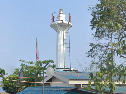
Date unknown (station established 1905). Active; focal plane 21 m (69 ft); white flash every 5 s. 14 m (46 ft) sround barbell-shpoed tower. Google has a street view and Bing has a satellite view. The street view shows the tops of both the newer tower on the right and the older one on the left. Located close to the historic tower. Site open, tower closed. ARLHS PHI-068; PCG-0031; Admiralty F2690; NGA 14396.
* Silaqui (Silaque) Island
Date unknown. Active; focal plane 13 m (43 ft); two white flashes every 10 s. 9 m (30 ft) round hourglass-shaped white fiberglass tower. Angel Maramot has posted a photo, Gil Jacinto has an aerial view, and Google has a fuzzy satellite view. Located at the northern tip of a small (but inhabited) island off the northern tip of the Cape Bolinao peninsula. Accessible only by boat. Site open, tower closed. PCG-0032; Admiralty F2689; NGA 14397.

Cape Bolinao Light, Bolinao, July 2016
Google Maps drone view by Carlo Caacbay
[Anda (Cabarruyan Island) (3?)]
Date unknown. Active; focal plane 3.5 m (12 ft); red flash every 5 s. 3 m (10 ft) post. NGA lists a "fiberglass structure," presumably a barbell-shaped fiberglass tower, showing a green flash every 5 s, and the Admiralty listed that light in a 2010 notice to mariners. No such structure has been found in Google's satellite view but a 2016 street view shows the present beacon with its red light. A very popular beach resort, Anda is an island municipality on the east side of Cape Bolinao. PCG-0030; Admiralty F2690.5; NGA 14396.2.
* Lucap (Alaminos)
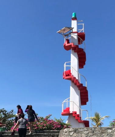
Date unknown. Active; focal plane about 20 m (66 ft); green flash every 5 s. Approx. 18 m (59 ft) slender square white concrete tower with an external concrete stairway winding around the tower. The stairway is painted red in the photo by Phil Alvarez at right and another 2018 photo by Angelic Junel Gonzales. Puyat Ang Gago has a 2019 photo showing the tower floodlit at night and Google has a 2015 street view and a satellite view. Small lights of this distinctive design are common in the Philippines. Located on the waterfront at Lucap, on the west side of Lingayen Gulf about 5 km (3 mi) northeast of Alaminos. Site open, tower can be climbed. . ARLHS PHI-116; PCG-0029; Admiralty F2691; NGA 14398.
[Portuguese Point (Port Sual)]
Date unknown. Active; focal plane 16 m (51 ft); red flash every 5 s. 10 m (33 ft) concrete mast, similar to a telephone pole. A 2017 photo is available on Facebook, a distant view from the sea is available and Google has an indistinct satellite view. The light stands in the midst of ruins of a Spanish watchtower. Portuguese Point is a peninsula sheltering the harbor of Sual, one of the earliest Spanish outposts in the Philippines. Located on the point, at the southwestern corner of Lingayen Gulf. Site open, tower closed. PCG-0028; Admiralty F2692; NGA 14399.
Dagupan (Gaucet Point, Bonuan) (3)
Date unknown (station established about 1885). Active; focal plane 14 m (46 ft); white flash every 5 s. Approx. 11 m (36 ft) slender square white concrete tower with an external concrete stairway winding around the tower, very similar to the Lucap light. The railing and the sides of the steps are painted yellow. Gerard Castaneda has a good photo and Google has a satellite view. The original lighthouse was a cast iron tower similar to San Fernando (1). It was replaced in the 1920s by a 5 m (17 ft) octagonal concrete structure with a lantern centered on the top. Oddly, the international light lists continue to describe this structure. Dagupan is a city of about 175,000 residents at the head of Lingayen Gulf. Located on the property of a naval detachment on the north side of the entrance to the Dagupan River. Site status unknown. ARLHS PHI-104; PCG-0027; Admiralty F2694; NGA 14400.

Lucap Light, Lucap, December 2018
Google Maps photo by Phil Alvarez

La Union Province (Eastern Lingayen Gulf) Lighthouses
* Damortis
Date unknown. Active; focal plane 12 m (39 ft); red flash every 5 s. 10 m (33 ft) slender round white concrete tower with an external concrete stairway winding around the tower. Naldsrufin Bucsit has a 2018 photo and Google has a closeup 2023 street view and a satellite view. Located at the foot of the pier in Damortis, a small fishing port about 30 km (19 mi) northeast of Dagupan. Site open, tower closed (fenced). PCG-0026; Admiralty F2696; NGA 14405.
* Santa Rita
Date unknown. Active; focal plane 14 m (46 ft); red flash every 5 s. 12 m (39 ft) square cylindrical concrete church steeple; the light is shown from a bracket mounted in the belfry. Christian Lubrin has a 2017 photo and Google has a satellite view and a street view through trees. Located in the village of Santa Rita, on the east side of Lingayen Gulf about 40 km (25 mi) north of Dagupan. Site open, tower status unknown. PCG-0025; Admiralty F2697; NGA 14406.
* San Fernando Point (Poro Point) (1)
1885 (Spanish). Inactive. Approx. 6 m (20 ft) round cylindrical steel tourelle, prefabricated in France. U.S.-built keeper's house nearby. Lantern removed long ago. One of eight steel towers prefabricated in France for the Philippines. Dmitry Ishanin has a closeup photo, Sigmund Perona also has a closeup, another photo (2/3 the way down the page) shows both light towers, and Google has a satellite view. Located at the edge of the cliff near the modern lighthouse (next entry); clearly endangered by neglect and by erosion of the cliff. Site open, tower closed (military installation). ARLHS PHI-097.
** San Fernando Point (Poro Point) (2?)
1979. Active; focal plane 33 m (107 ft); two white flashes every 10 s. 19 m (62 ft) round concrete tower with gallery but no lantern, unpainted. Several small buildings around the base of the tower. A 2018 photo at right, Rizza Fernandez has a 2015 photo, a distant photo is available, Wikimedia has a view from the sea by Ramon Velazquez, and Google has a satellite view of the station. It's clear from the closeup photo that the height of the lighthouse is much greater than the 8 m (27 ft) listed. In 2012, after years of negotiation, the Poro Point Management Corporation signed an agreement to restore the lighthouse. In 2015 the corporation was seeking bids for tourist development at the station; this resulted in improved signage and widening of the access road to allow parallel parking.. Located on a headland at the end of a club-shaped peninsula about 5 km (3 mi) west of San Fernando, at the eastern entrance to Lingayan Gulf. Site open, tower open but no schedule information is available. . ARLHS PHI-053; PCG-0024; Admiralty F2698; NGA 14408.
[San Fernando Range Rear]
Date unknown. Active; focal plane 37 m (121 ft); continuous green light. 18 m (59 ft) orange steel mast carrying a triangular daymark, point down. Google has a street view and a satellite view. This is the entrance range for San Fernando Bay. The front light is on a much shorter mast on the waterfront. Located behind the athletic field of the La Union National High School in San Fernando. Site status unknown. PCG-0022; Admiralty 2702.1; NGA 14416.

San Fernando (Poro Point) Light, San Fernando, April 2018
ex-Google Plus photo by Viking Jelly
* [Darigayos Point]
Date unknown. Active; focal plane 10 m (33 ft) (?); green flash every 5 s. Approx. 12 m (39 ft) concrete pillar. The light is at the right in Ralf Tammocalao's photo and Google has a street view (in the center; tower on the right is a war memorial) and a satellite view. The listed focal plane is certainly too low. Located on a hilltop on the south side of Darigayos. Site status unknown, but the light is visible from the highway. PCG-0021; Admiralty F2705; NGA 14424.

Ilocos Sur Province Lighthouses
* Tagudin
Date unknown (station established 1911). Active; focal plane 8 m (26 ft); two red flashes every 5 s. 7 m (23 ft) concrete post with a buttressed base. Wikimapia has a fuzzy photo, and Google has a satellite view. Located several blocks off the beach in the Farola neighborhood of Tagudin, the southernmost town in Ilocos Sur. Site open, tower closed. PCG-0020; Admiralty F2708; NGA 14428.
* Candon
1950s. Active; focal plane 15 m (49 ft); red flash every 5 s. Approx. 11 m (36 ft) concrete post with a buttressed base. A good photo and a closeup photo are available and Google has a street view (seen at right) and a satellite view. Located at the north end of Darapidap Beach in Candon, in Ilocos Sur province. Site open, tower closed. PCG-0019; Admiralty F2712; NGA 14432.
* Apatot (San Esteban)
2011. Active; focal plane 10 m (33 ft); red light, 2.5 s on, 2.5 s off. 8 m (26 ft) barbell-shaped round white fiberglass tower. A photo is available, a blogger has a photo (first photo on the page) and Google has a closeup street view and a satellite view. Located next to Apatot Barangay Hall on the waterfront of the town. Site open, tower closed. PCG-0502; Admiralty F2713; NGA 14434.
Pandan
Date unknown. Active; focal plane 12.5 m (41 ft); green flash every 5 s. 8 m (26 ft) concrete tower. The top of the light is seen in a Google street view but the light is hard to see in Google's satellite view. Not to be confused with the Pandan Point lighthouse in Catanduanes. Located "on the beach," according to NGA, in Pandan. Site status unknown. Admiralty F2714; NGA 14436.

Candon Light, Candon, January 2016
Google Maps street view
Puropingit (Magsingal)
2011. Active; focal plane about 14 m (46 ft); white flash every 10 s. Approx. 10 m (33 ft) barbell-shaped round white fiberglass tower. No photo available but Google has a satellite view. Located on a tombolo (island joined to the mainland by a narrow neck) at Magsingal. Site status unknown. PCG-0542; Admiralty F2715; NGA 14438.
Salomangue (Salomague, Dadarat) (2)
2016. Active; focal plane 10 m (33 ft); red flash every 5 s, 9 m (30 ft) white concrete tower. Google has a 2023 street view (a portion is seen at right) and a fuzzy satellite view. NGA describes the former light as a framework tower. Salomague is also the location of the Ilocos Cruse Terminal. Located at the Philippine Coast Guard Station on the south side of Salomague. Site status unknown. Admiralty F2716; NGA 14440.
* Cabangtalan (2)
Date unknown. Active; focal plane unknown; white flash every 5 s. Approx. 8 m (26 ft) square concrete skeletal tower. Google has a street view and a satellite view. NGA describes the former light as a fiberglass structure. Located on the waterfront in Cabangtalan. Site open, tower closed. Admiralty F2718; NGA 14442.

Ilocos Norte Province Lighthouses
* [Arboledan Point (Currimao, Gaang Bay) (1)]
1906. Inactive. This was an approx. 9 m (30 ft) stone tower, part of what is believed to be an old Spanish outpost built to warn of attacks by Moro pirates and then used under U.S. administration as a lighthouse. About 5 m (16 ft) of the tower has been preserved. Google has a street view and a satellite view. Located beside the coastal road at the entrance to Gaang Bay and Currimao, about 32 km (20 mi) south of Laoag City. Site and tower closed (private property) but the tower is only a few meters from the street.
 

Salomangue Light, Salomangue, April 2023
Google Maps street view
 
* Arboledan Point (Currimao, Gaang Bay) (2)
Date unknown (station established 1906). Approx. 7 m (23 ft) slender square concrete tower, with an external concrete stairway winding around the tower. A photo is at right, Zeng Deliang has a closeup photo, and Google has a 2020 drone view. ARLHS PHI-004.
* Arboledan Point (Currimao, Gaang Bay) (3)
Date unknown (station established 1906). Active; focal plane 49 m (161 ft); red flash every 5 s. 10 m (33 ft) round hourglass-shaped tower, painted white. A photo is at right, Zeng Deliang has a photo, Mapio.net has several photos, and Google has a 2020 drone view, a satellite view of the station and a distant street view from the coast. Several Currimao tourist sites list the lighthouse as an attraction. In the satellite image the newer lighthouse appears a few feet to the left (west) of its predecessor. Located on heights above the historic tower. Site open, tower closed. Admiralty F2720; NGA 13996.
**** Cape Bojeador (Burgos)
1892 (Spanish). Active; focal plane 118 m (386 ft); three white flashes every 5 s. 20 m (66 ft) octagonal cylindrical brick tower, painted white, attached to a 1-story brick keeper's house. Portions of the original 1st order Fresnel lens, badly damaged by an earthquake in 1990, remain in the lantern; a small modern lens is mounted inside what's left of the original lens. The original rotating mechanism is intact. Assistant keeper's houses and other light station buildings. This is a staffed station. A photo is at the top of this page, Oleey Lee has 2023 photo, another photo is available, John Ryan Cordova has a closeup of the tower, Wikimedia has numerous photos, a drone view is available, and Google has a street view and a satellite view. This historic lighthouse, with its classic Spanish colonial architecture, is easily the best known and most visited light station in the country; the keepers often provide tours. It had been in dilapidated condition for years and was further damaged by Typhoon Feria in 2001. In 2003 the Coast Guard signed an agreement with Cape Bojeador Lighthouse Development Inc., a quasi-public, nonprofit organization that plans to restore and operate the lighthouse. This effort was reported to be supported by the government of Ilocos Norte province. However, there was a long delay. A January 2010 photo is nearly identical to a 2005 photo. In 2014 the work finally got underway. Ian Carolino has a photo of the lighthouse surrounded by scaffolding, another photo shows the tower repainted, and the photo at the top of this page shows the results of the restoration. Additional "rehabilitation" work was announced in 2017. Located at the northwestern corner of the island and the country 45 km (28 mi) north of Laoag. Accessible by road. Site and tower open. ARLHS PHI-012; PCG-0014; Admiralty F2722; NGA 14000.

Second and third Arboledan Point Lights, Currimao, February 2022
Google Maps photo by H U
Dialao Point
Date unknown. Active; focal plane unknown; four white flashes every 20 s. Described as a fiberglass structure; probably a round barbell-shaped tower about 10 m (33 ft) tall. No photo available and the lighthouse is not seen in Google's satellite view. Located on a rounded cape at the northernmost point of Luzon. Site status unknown. Admiralty F2723; NGA 14002.

Information available on lost lighthouses:

Notable faux lighthouses:

Adjoining pages: East: Northeast Luzon | South: Southwest Luzon

Return to the Lighthouse Directory index | Ratings key

Created July 24, 2005. Checked and revised October 15, 2023. Lighthouses: 35. Site copyright 2023 Russ Rowlett and the University of North Carolina at Chapel Hill.