Lighthouses of Western North Korea

For most of its history Korea was an independent kingdom, or at least an autonomous kingdom under Chinese influence. This came to an end in 1910 when Japan annexed all of Korea. At the end of World War II in 1945 the 38° parallel was established as the dividing line between U.S. and Soviet zones of occupation, and in 1948 separate civil administrations were established in the two halves of the country. The Korean War (1950-53) ended in a draw with the armistice line falling close to the prewar 38° line. The northern half of Korea became the Democratic People's Republic of Korea (DPRK), commonly called North Korea, a reclusive Communist state that bars all but a few carefully selected foreigners.

As a result of this history and the current political situation there is very little information available on the lighthouses of North Korea. Fortunately lighthouses have been a favorite subject for DPRK postage stamps and these stamps provide images of some of the lighthouses. Also, satellite imagery confirms the presence of many lighthouses.

North Korea is divided into nine provinces plus the capital city and one "special city." North Korea has two coastlines; the east coast faces the East Sea (Sea of Japan) and the west coast faces the West Sea (Yellow Sea) and Korea Bay. This page covers lighthouses of the west coast and there is a separate page for the lighthouses of the east coast. Namp'o is the one major port on the west coast.

The romanization system used in North Korea differs from the Revised Romanization system used in South Korea. In Korean the word for a lighthouse is deungdae (등대); dan (formerly tan) is a cape, seom (som) or do (to) is an island, am or amseog is a rock, man is a bay, and hang is a harbor.

ARLHS numbers are from the ARLHS World List of Lights. Admiralty numbers are from volume M of the Admiralty List of Lights & Fog Signals. U.S. NGA List numbers are from Publication 112.

General Sources
Online List of Lights - Korea
Photos by various photographers posted by Alexander Trabas.
World of Lighthouses - North Korea
Photos by various photographers available from Lightphotos.net.
Leuchttürme auf Briefmarken
Postage stamp images posted by Klaus Huelse.
Leuchttürme Japans und Koreas auf historischen Postkarten
Historic postcard images, also posted by Klaus Huelse.
Navionics Charts
Navigation chart for North Korea.

Nampho Dam Light
Nampho Dam (P'i Do) Light, Nampho, September 2009
photo copyright Ray Cunningham; used by permission

South Hwanghae Province Lighthouses

South Coast Lighthouses
The Ongjin Islands off this coast are in South Korea (see the Incheon Area page). Disputes over fishing rights and other maritime issues have kept this area unsettled.

Jincho
Date unknown. Active; focal plane 9 m (30 ft) (?); white flash every 12 s. 16 m (52 ft) black round concrete tower. No photo available but Bing has a satellite view. Located on a reef on the east side of the approach to Haeju, the capital of South Hwanghae Province. Site and tower closed. Admiralty M4140; NGA 18096.
Sosuapdo
Date unknown. Active; focal plane unknown. Active; white light, pattern unknown. Concrete tower rising from a keeper's house. No photo available but Bing has a satellite view. Located on an island on the east side of the approach to Haeju, about 5 km (3 mi) north northeast of the Jincho Light. Site and tower closed. Charted by Navionics but not listed by the Admiralty.
Haricho
Date unknown. Active; focal plane 9 m (30 ft) (?); white flash every 12 s. 17 m (56 ft) red round concrete tower. No photo available and the light is inconspicuous in Google's satellite view. Located on a rocky islet at the western entrance to Haeju Bay. Site and tower closed. Admiralty M4138; NGA 18093.
Tongsangot (Cape Tongsan)
Date unknown. Active; focal plane unknown. Active; white light, pattern unknown. Concrete tower rising from a keeper's house. No photo available but Google has a satellite view. This is probably a historic lighthouse. Located on a sharp cape, the southwestern corner of the mainland of North Korea. Site and tower closed. Admiralty M4137.8.

West Coast Lighthouses
Monggumpo
Date unknown. Probably inactive; listed with focal plane 43 m (141 ft); two white flashes every 30 s. Approx. 13 m (43 ft) tower with lantern and gallery, probably painted white. The lighthouse is seen (barely) at the extreme left edge of Kim MyungGeun's 2019 photo and Google has a satellite view. Located on a rocky peninsula marking the entrance to an estuary forming the harbor of Monggumpo in Ryongyeon County, near the southwestern corner of North Korea. Site and tower closed. Not listed by the Admiralty and not charted by Navionics. NGA 18105.
Oryugigot (Oryuji Gi)
Date unknown. Probably inactive; listed with focal plane unknown (perhaps about 30 m (98 ft)); white flash every 15 s. No description and no photo available. Google's indistinct satellite view suggests a lantern atop a building of some kind. Located on a prominent cape in Jangyeon County. Site and tower closed. Not listed by the Admiralty and not charted by Navionics. NGA 18106.

Northwest Coast (Namp'o Approach) Lighthouses
Namp'o, North Korea's major west coast seaport, is a city of about 700,000 residents located on the north side of the Taedong River estuary.

Seodo (Sodo, So Do)
1908. Active; focal plane 94 m (308 ft); white flash every 20 s. 9.5 m (31 ft) round concrete tower with lantern and gallery, painted white. Google has a distant satellite view of the station. This is the landfall lighthouse marking the beginning of the approach to Namp'o. Located on an islet off the west end of the larger island of Chodo, about 30 km (19 mi) southwest of the entrance to the Taedong River. Site and tower closed. ARLHS NKR-005; Admiralty M4116; NGA 18112.
Songmun Am
Date unknown. Active; focal plane about 9 m (30 ft); white flash every 10 s. No description available and Google has an indistinct satellite view. Located on a reef about 1.2 km (3/4 mi) off the southeastern tip of Chodo. Site and tower closed. Admiralty M4117; NGA 18119.
Hibong Gak (Huibonggang, Chodo)
Date unknown. Active; focal plane 36 m (118 ft); white flash every 3 s. 8.5 m (28 ft) octagonal concrete tower, rising from a 1-story keeper's house. No photo available but Google has a satellite view. Located at the southeastern tip of Chodo, marking the strait between the island and the mainland. Site and tower closed. ARLHS NKR-026; Admiralty M4116.5; NGA 18118.5.

Seodo Light, West Sea
DPRK postage stamp
Heugam (Kuro Iso)
Date unknown. Active; focal plane 8 m (26 ft); white flash every 9 s. No description and no photo available and Google has only a fuzzy satellite view. Located on the northern tip of an islet off a promontory sheletring the port of An-chon about 13 km (8 mi) northeast of Chodo. Site and tower closed. Admiralty M4117.5; NGA 18118.
Jamaedo (Chamae Do, Jamae Do)
1917. Active; focal plane 43 m (138 ft); white flash every 18 s. 9.5 m (31 ft) round concrete tower with lantern and gallery, painted white. A 2009 photo is at right, a postage stamp image is available, and Google has a satellite view. This light marks a turn in the approach to Namp'o. Located on an islet northwest of Sok Do about 16 km (10 mi) west of the Taedong River entrance. Site and tower closed. ARLHS NKR-002(=011); Admiralty M4118; NGA 18116.
Chando (Ch'an Do)
Date unknown. Active; focal plane 38 m (125 ft); white flash every 15 s. 5.5 m (18 ft) round white concrete tower. No photo available but Bing has a satellite view of the station. Located on a steep-sided island about 5 km (3 mi) west of P'i Do. Accessible only by boat. Site and tower closed. ARLHS NKR-024; Admiralty M4120; NGA 18124.
Pido (P'i Do, Phido) (2)
Around 1986 (station established 1905). Active; focal plane 86 m (282 ft); two white flashes every 3 s. 33 m (108 ft) square pyramidal masonry tower with lantern and gallery, centered on a large 1-story masonry administration building. Ray Cunningham's 2009 photo appears at the top of this page, Eric Lafforgue has a 2008 photo, Lightphotos.net has a closeup, Sergio Canobbio also has a closeup, Huelse has a postage stamp image, and Google has a satellite view. Lighthouse Digest has an earlier postage stamp image of the original lighthouse. This is North Korea's tallest and most powerful lighthouse. The light marks the actual entrance to the Taedong River and the port of Nampho. Since 1986 the entrance has been closed by the West Sea Barrage (Nampho Dam), a dam about 8 km (5 mi) long; Google has a satellite view of this structure. Ships enter and leave the river through locks at the extreme south end of the barrage, between the island of P'i Do and the south bank. The DPRK government often takes groups of visitors to the dam, making this the only lighthouse in the country regularly seen by foreigners. The lighthouse is built on the highest point of P'i Do. Site open to official tours, tower closed. ARLHS NKR-004; Admiralty M4126; NGA 18132.
Oripori (Ori P'o, Orip'o-ri)
Date unknown. Active; focal plane 36 m (118 ft); continuous white light. 7 m (23 ft) white concrete tower. No photo available but Google has a satellite view. Located on a promontory on the south side of the Taedong estuary about 5 km (3 mi) southeast of the Pido lighthouse. Site and tower closed. ARLHS NKR-028; Admiralty M4128; NGA 18136.
Jamae Do Light
Jamaedo (Chamae Do) Light, West Sea, 2009
D.P.R. of Korea government photo

South Pyongan Province Lighthouses

Namp'o City Lighthouse
Pibaldo (Bibaldo, Pibal Do, Pibalto, Phibaldo, Nampho, Chinnam-po)
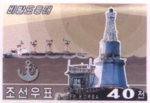
1909 (possibly rebuilt after the Korean War). Active; focal plane 26 m (85 ft); white flash every 9 s. 11 m (36 ft) multistage tower: a skeletal tower is mounted on a round metal equipment room atop a hexagonal concrete base. Entire lighthouse is white. A postage stamp image is at right, Huelse has a historic postcard view and Google has a satellite view. The lighthouse is built on a volcanic rock connected to the mainland by a footbridge. Another postcard view shows an earlier appearance of the lighthouse. Located in the center of the harbor of Namp'o, on the north side of the Taedong River. Site and tower closed. ARLHS NKR-013; Admiralty M4132; NGA 18148.

Taedong Bay Lighthouses
Jirido (Chirido, Chiri-Do)
Date unknown. Active; focal plane 20 m (66 ft); white flash every 12 s. 7.5 m (25 ft) octagonal white concrete tower. No photo available but Google has a distant satellite view of the station. This light appears to act as a leaading light for vessels in the final approach to Namp'o. Located on a small island in Taedong Bay about 4 km (2.5 mi) northwest of P'i Do. Accessible only by boat. Site and tower closed. ARLHS NKR-025; Admiralty M4122; NGA 18128.
Deokdo (Tokdo, Tok To, Toku Somu)
Date unknown. Active; focal plane 92 m (302 ft); white flash every 15 s. No description available but Bing has a satellite view of the station. Located on an island about 15 km (9 mi) northwest of P'i Do. Accessible only by boat. Site and tower closed. Admiralty M4119; NGA 18120.
Pibaldo Light
Pibaldo Light, Nampho
postage stamp image courtesy of Michel Forand

North Pyongan Province Lighthouses

Pansong (Banseong) Archipelago Lighthouses
The northeast corner of Korea Bay is shallow with numerous banks and islands known collectively as the Pansong Islands.

Napdo (Nap To, Rapto)
Date unknown. Active; focal plane unknown; white flash every 5 s. Square tower, height unknown. No description and no photo available but Bing has a satellite view. Napdo is the most remote of the Pansong Islands in Korea Bay, located about 60 km (38 mi) offshore, halfway between the Taedong and Yalu River entrances. Site and tower closed. Admiralty M4113; NGA 18152.
Taegamdo (Hamseong Yoldo, Daegamdo)
Date unknown. Active; focal plane unknown; white flash every 12 s. No description and no photo available and Google has only a fuzzy satellite view of the station. The light marks a gap in a long chain of islands fringing the coast off the entrance to the Chongchon estuary and Anju. Site and tower closed. Admiralty M4112.5; NGA 18149.
Taehwado (Taehwa Do, Daehwado)
1909. Active; focal plane 95 m (312 ft); white flash every 20 s. 24 m (79 ft) hexagonal cast iron skeletal tower, painted white. No photo available but Bing has a satellite view of the station. Taehwado is an island in Korea Bay about 50 km (30 mi) southeast of the Yalu River entrance. The island was the scene of bitter fighting in late 1951, during the Korean War. The Admiralty misspells the name as Tachwa Do. Located on the south side of the island. Site and tower closed. ARLHS NKR-030; Admiralty M4112; NGA 18156.

Yalu River Entrance Lighthouses
The Yalu River forms the border between North Korea and China. The provincial capital and port of Sinuiju is on the east (North Korean) side of the river mouth and Dandong is the Chinese port on the west side.

Sogyedo Breakwater
Date unknown. Active; focal plane 12 m (39 ft); continuous red light. 6 m (20 ft) round red tower. No photo available. Although the Admiralty lists this as a breakwater light, Google's satellite view of the listed location is at the tip of a headland. Navionics also charts this location. Located at the southern tip of an island about 16 km (10 mi) east of the Suundo lighthouse. Site and tower closed. Admiralty M4104.5.
Suundo (Suun Do)
1909. Active; focal plane 48 m (157 ft); white flash every 10 s. 8 m (26 ft) round cylindrical concrete tower with lantern and gallery, attached to a 1-story concrete keeper's house. Entire lighthouse is white. A photo is at right and Google has a satellite view of the station. Suun Do is the westernmost in a chain of half a dozen small islands about 20 km (13 mi) southeast of the Yalu River entrance. Located on the highest point of the island. Site and tower closed. ARLHS NKR-007; Admiralty M4104; NGA 18160.

Suundo Light, West Sea
DPRK news agency photo
Undo (Un Do, Yubundo)
Date unknown. Active; focal plane 25 m (82 ft); two white flashes every 6 s. 7 m (23 ft) square concrete tower with lantern and gallery and attached to a small equipment building. Entire lighthouse is white. Huelse posted the postage stamp image at right and Google has a satellite view. Located on an islet about 13 km (8 mi) southeast of the Yalu River entrance. Located on the highest point of the island. Site and tower closed. ARLHS NKR-031; Admiralty M4105; NGA 18164.
Dasado (Tasado) Hang
Date unknown. Active; focal plane unknown; white flash every 3 s. No description and no photo available but Google has an indistinct satellite view. Located on a rocky ridge in the mouth of the Yalu River about 4 km (2.5 mi) west of the North Korean naval base at Dasado. Admiralty M4106.
Munbakdo
Date unknown. Active; focal plane unknown; white flash every 3 s. No description and no photo available but Bing has a distant satellite view. NGA has an incorrect Admiralty number for this light. Located atop a small island but high island in the mouth of the Yalu River about 5 km (3 mi) northwest of the Dasado light. Admiralty M4106.5; NGA 18166.
Sampo
Date unknown. Active; focal plane 62 m (203 ft); white light, 3 s on, 3 s off. 10 m (33 ft) hexagonal red brick tower. No photo available. The location of this light is unclear; NGA chart 95041 places it on a high hill about 2.5 km (1.5 mi) east of the river but Bing's satellite view of that location does not show the tower. Site and tower closed. ARLHS NKR-029; Admiralty M4107; NGA 18168.
Maando (Maan Do)
Date unknown. Active; focal plane 72 m (236 ft); white flash every 5 s. 8 m (26 ft) round brick tower, painted white. No photo available but Google has an indistinct satellite view. Located at the southwestern tip of Sin Do, a large island in the mouth of the Yalu River, marking the entrance to the western mouth of the river, opposite the Chinese port of Donggang. Site and tower closed. ARLHS NKR-027; Admiralty M4100; NGA 18176.

Undo Light, West Sea
DPRK postage stamp

Information available on lost lighthouses:

Notable faux lighthouses:

Adjoining pages: South: Incheon Area | West: Eastern Liaoning

Return to the Lighthouse Directory index | Ratings key

Posted September 24, 2007. Checked and revised June 17, 2023. Lighthouses: 27. Site copyright 2023 Russ Rowlett and the University of North Carolina at Chapel Hill.