Lighthouses of Perú: Lake Titicaca

The Republic of Perú occupies the central west coast of South America, between Chile on the south and Ecuador on the north. It has a lengthy coastline (about 2400 km or 1500 mi) on the Pacific Ocean. There is also navigation on Lake Titicaca in the southeastern corner of the country and on the upper Amazon River in the northeastern corner.

Lake Titicaca is a large lake in the Andes Mointains on the border between Peru and Bolivia. It is the largest lake in South America and the highest navigable lake in the world with an elevation of 3812 m (12,507 ft). Its lights are without a doubt the highest lighthouses in the world. There are additional lights on the lake in Bolivia.

The regional and provincial capital of Puno, at the east end of Lake Titicaca, has a population of about 150,000 and is by far the largest settlement on the lake.

The Spanish word for a lighthouse is faro. In Spanish isla is an island, cabo is a cape, punta is a promontory or point of land, péñon is a rock, arrecife is a reef, bahía is a bay, ría is an estuary or inlet, estrecho is a strait, río is a river, and puerto is a port or harbor. Also, the Spanish word canal means a natural channel, not an artificial canal.

Lighthouses in Perú are owned by the navy (Marina de Guerra del Perú) and managed by the navy's Dirección de Hidrografía y Navegación (DHN) through its Departamento de Señalización Nautica. In addition to the coastal lights DHN also manages the lights on the Amazon River and on Lake Titicaca.

Some of Peru's lighthouses are located in natural protected areas. A permit from the natural areas protection agency Sernanp may be required to visit these lights.

DHN numbers are Peruvian light list numbers as recorded by Bolivia's Servicio Nacional de Hidrografía Naval. Currently none of the Peruvian lights of Lake Titicaca are listed in the ARLHS World List of Lights and the international light lists do not include lights of landlocked waterways like Titicaca.

General sources
World of Lighthouses - Peru
Photos by various photographers available from Lightphotos.net.
Lighthouses in Puno, Peru
Photos by various photographers available from Wikimedia.
Aviso a los Navegantes - Agusto 2010
Published by Bolivia's Servicio Nacional de Hidrografía Naval, this notice to mariners (a pdf document) has on page 7 a light list for the Peruvian lights on Lake Titicaca.
Navionics Charts
Navigation chart for Lake Titicaca.


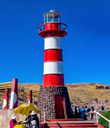
Puno Light, Puno, September 2011
Flickr Creative Commons photo by Bruce Tuten

Lighthouses
* Puno
Date unknown. Active (privately maintained and unofficial); focal plane 10 m (33 ft); white light, pattern unknown. 9 m (30 ft) round metal tower with lantern and gallery, mounted on a round stone base. Tower painted with red and white horizontal bands. Bruce Tuten's photo is above, another closeup photo, a 2022 photo, and a 2009 photo are available, Lightphotos.net has several photos, and Google has a street view and a satellite view. Located at the Plaza del Faro on the waterfront of Puno, at the western end of the lake. Site open, tower closed.
Punta Churo
Date unknown. Active; focal plane 59 m (194 ft); white flash every 5 s. 6 m (20 ft) triangular skeletal (?) tower, painted white. No photo available but Google has a satellite view. Located on a promontory at the northern tip of the Socca Peninsula, about 30 km (19 mi) east northeast of Puno. Site status unknown. DHN-3202.
Isla Taquile
Date unknown. Active; focal plane 41 m (135 ft); two white flashes every 10 s. 6 m (20 ft) triangular tower, painted with red and white horizontal bands. No photo available but Google has a satellite view. Isla Taquile is an inhabited island about 45 km (28 mi) east of Puno. Located at the southern tip of the island. Site status unknown. DHN-3203.
* Punta Pomata
Date unknown. Active; focal plane 69 m (226 ft); white flash every 10 s. 10 m (33 ft) hexagonal pyramidal skeletal tower, mostly enclosed by green panels. Google has a street view (a portion is seen at right) and a satellite view. Located on a high promontory just off highway 3-S on the southern shore of the lake north of Pomata. Site open, tower closed. DHN-3207.
Isla Anapia
Date unknown. Active; focal plane 55 m (180 ft); white flash every 5 s. 6 m (20 ft) square pyramidal skeletal tower with enclosed equipment room at the base, painted with red and white horizontal bands. No photo available but Google has a distant satellite view. Located on an island at the southeasternmost point of Peruvian territory in the lake. Site status unknown. DHN-3513.
Isla Suana
Date unknown. Active; focal plane 10 m (33 ft); white flash every 5 s. Approx. 9 m (30 ft) triangular cylindrical mast mounted on a square cylindrical base, presumably concrete, painted with black and white horizontal bands. Sibling of Isla Taquile. No photo available but Bing has a satellite view. Located at the western end of an island, about 3 km (2 mi) south of Isla Anapia. Site status unknown. DHN-3514.

Information available on lost lighthouses:


Punta Pomata Light, Pomata, October 2014
Google Maps street view

Notable faux lighthouses:

Adjoining pages: East: Bolivia | West: Southern Perú

Return to the Lighthouse Directory index | Ratings key

Posted June 2002. Checked and revised August 28, 2023. Lighthouses: 6. Site copyright 2023 Russ Rowlett and the University of North Carolina at Chapel Hill.