Lighthouses of Russia: Northern Chukotka

Russia (Россия, Rossiya in Russian) is by far the world's largest country, spanning a little over 150° in longitude. It is organized as the Russian Federation (Rossiyskaya Federatsiya) with members known as federal subjects (sub'yekty federatsii). Russia is primarily a continental nation but it has important coastlines on the Baltic, Black, and Caspian Seas and very long coastlines on the Arctic Ocean and North Pacific Ocean. To guard these coasts it operates hundreds of lighthouses, many of them historic.

Russia's Northern Sea Route (Sevmorput) is a well developed sea lane extending through the Arctic Ocean to connect the Atlantic and Pacific. The route extends from Murmansk at the northwestern corner of Russia past the island of Novaya Zemlya and parallel to the Siberian coast all the way to the Bering Strait.

The Chokotka Autonomous Okrug (autonomous district) is the unit of the Russian Federation that occupies the easternmost extension of Siberia, reaching toward Alaska. It is a peninsula with coastlines facing north on the East Siberian Sea and Chukchi Sea (basins of the Arctic Ocean) and south on the Bering Sea (a basin of the Pacific Ocean). This page has lighthouses of the Arctic coast and there is a separate page covering the Pacific coast.

Although Russian explorers reached this remote area in the 17th century and mapped it in the 18th century, full control by the Russian Empire did not occur before late in the 19th century.

The Russian word for a lighthouse is mayak (маяк); ostrov is an island, poluostrov is a peninsula, mys is a cape, bukhta or guba is a bay, zaliv is a larger bay or gulf, proliv is a strait, reka is a river, and gavan' is a harbor.

Russian lighthouses are owned by the Russian Navy and maintained by the Navy's Office of Navigation and Oceanography (Управление навигации и океанографии).

ARLHS numbers are from the ARLHS World List of Lights. Russian light list (RU) numbers are from Russian Navy Publication 2111 as reported by the Admiralty. Admiralty numbers are from volume L of the Admiralty List of Lights & Fog Signals and U.S. NGA List numbers are from Publication 115.

General Sources
World of Lighthouses - Arctic Coast of Russia
Photos by various photographers available from Lightphotos.net.
Online List of Lights - Russia - Arctic Sea Coast
Photos by various photographers posted by Alexander Trabas.
Chukotka
Map of Chukotka from rohrmannspace.net.
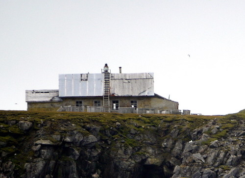
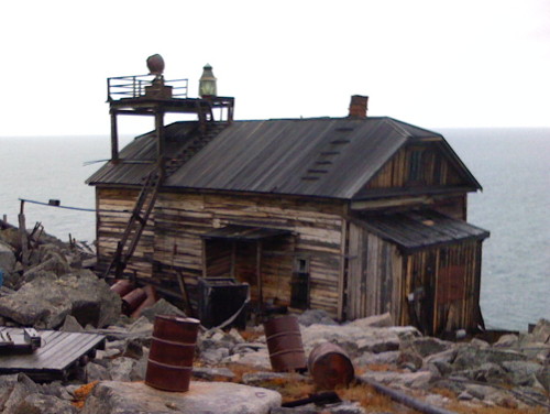
Ostrov Kolyuchin Light
Ostrov Kolyuchin Light, Iultinsky District, August 2011
ex-Panoramio photo copyright Harry Shave; used by permission
Bilibinsky District Lighthouses

Kolyma Gulf Lighthouses
The Kolyma Gulf is a bight of the East Siberian Sea extending eastward from the delta of the Kolyma River.
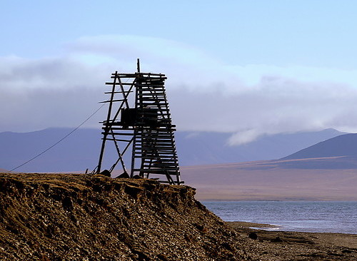
Mys Letyatkina
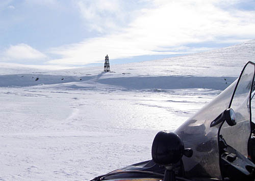
Date unknown. Inactive (?); focal plane unknown; white flash every 5.5 s. Approx. 15 m (49 ft) square pyramidal wood skeletal tower. A photo is at right but Google has only a distant satellite view of the headland. Located on a high bluff about 80 km (50 mi) east of the Kolyma River Delta. Site status unknown. NGA 17660.
Mys Bol'shoy Baranov
Date unknown. Inactive (?); focal plane 23 m (75 ft); white flash every 5.5 s. 12 m (39 ft) square pyramidal wood skeletal tower. No photo available and Google has only a distant satellite view of the headland. Located on a prominent cape about 100 km (60 mi) east of the Kolyma River Delta. Site status unknown. NGA 17664.
Malaya Baranikha
Date unknown. Inactive (?); focal plane 50 m (164 ft); white flash every 7 s. 12 m (39 ft) square pyramidal wood skeletal tower. No photo available and Google has only a distant satellite view of the location. Located on the west side of the Malaya Baranikha River delta. Site status unknown. NGA 17668.
Mil'kera
Date unknown. Inactive (?); focal plane 43 m (141 ft); white flash every 4 s. 13 m (43 ft) square pyramidal wood skeletal tower. No photo available and Google has only a distant satellite view of the location. Located on the west side of the Mil'kera River delta. Site status unknown. NGA 17672.
Rauchua-Vostochnyy
Date unknown. Inactive (?); focal plane 17 m (56 ft); white flash every 3 s. 14 m (46 ft) square pyramidal wood skeletal tower. No photo available and Google has only a distant satellite view of the location. Located on a sand spit fronting the Rauchua River delta. Site status unknown. NGA 17676.
Mys Letyatkina Light
Mys Letyatkina Light, Bilibinsky District, April 2011
Snegohod.org photo (no longer online); reproduction permitted with attribution

Chaunsky District Lighthouses

Ayon Island Lighthouses
Ayon Island is a large, roughly rectangular island on the west side of the entrance to Chaunskaya Bay.
* Ayon
Date unknown. Active; focal plane 34 m (112 ft); white flash every 1.3 s. 15 m (49 ft) square pyramidal wood skeletal tower. The tower carries a slatted daymark painted black with a white vertical stripe on each side. Vanillin Ivander's photo is at right, he has a second photo, there is a YouTube video taken from the top of the lighthouse and Google has a satellite view. Ayon is a Chukchi settlement on the northwestern side of Ayon Island; the village had a population of 252 in 2010. Located on a bluff above the East Siberian Sea on the west side of the village. Site open, tower closed. RU 2111-8600; Admiralty L9658; NGA 17680.
Ayon Severnyy
Date unknown. Active; focal plane 39 m (128 ft); white flash every 10 s. 17 m (56 ft) square pyramidal wood skeletal tower. No photo available and Google has only a distant satellite view of the area. Located on a ridge near the northern tip of Ayon Island. Site status unknown. Admiralty L9658.5; NGA 17684.
Ostrov Chenkuul'
Date unknown. Active; focal plane 26 m (85 ft); white flash every 5 s. 11 m (36 ft) square wood skeletal tower. No photo available and Google has only a distant satellite view of the island. Located on a barrier island off the northeastern coast of Ayon Island, marking the entrance to Chaunskaya Bay. Site status unknown. Admiralty L9658.8; NGA 17688.
Konta
Date unknown. Active; focal plane unknown; white flash every 6 s. Approx. 10 m (33 ft) square pyramidal wood skeletal tower. No photo available and Google has only a fuzzy satellite view of the area. Located on a headland on the east side of Ayon Island, opposite Ostrov Bol'shoy Routan. Site status unknown. Admiralty L9658.9; NGA 17688.5.

Ayon Light, Ayon, April 2016
ex-Google Plus photo by Vanillin Ivander

Pevek Area Lighthouses

The district capital of Pevek, on the east side of Chaunskaya Bay, has a population of about 4700. Pevek formerly served gulag camps where the prisoners mined uranium; during the Cold War it also supported a nearby Soviet Air Force base, now closed. Pevek is now an icebreaker and coast guard base and the home of the Marine Operations Headquarters that manages the Northern Sea Route between the Bering Strait and the mouth of the Lena River. The town is sheltered behind Routan Island and the approach from the East Siberian Sea is through the narrow Pevek Strait between the island and the mainland.
Kosa Routan (Rautan)
Date unknown. Active; focal plane 16 m (52 ft); white flash every 7 s. 10 m (33 ft) square pyramidal wood skeletal tower. Oleg Fomin's photo is at right and the shadow of the lighthouse is visible in Google's satellite view. The light guides vessels approaching Pevek. Located on a sand spit (kosa) extending from the east end of Ostrov Bol'shoy Routan, an island that shelters the Pevek area. Accessible only by boat. Site status unknown. NGA 17692.
Bol'shoy Routan Range Rear
Date unknown. Active; focal plane unknown; yellow flash every 4 s. Approx. 12 m (39 ft) square skeletal tower. No photo available but Google has a satellite view. This northbound range guides vessels leaving Pevek. Located on the east coast of Ostrov Bol'shoy Routan, about 3 km (2 mi) south of the base of the sand spit. Accessible only by boat. Site open, tower closed. NGA 17696.51.
Bol'shoy Routan Range Front
Date unknown. Active; focal plane unknown; yellow flash every 2 s. Approx. 12 m (39 ft) square skeletal tower. No photo available and the light is seen in Google's satellite view. Located on the east coast of Ostrov Bol'shoy Routan, about 1 km (0.6 mi) south of the rear light. Accessible only by boat. Site open, tower closed. NGA 17696.5.
Mys Prolivnyy Range Front
Date unknown. Active; focal plane unknown; quick-flashing white light. Approx. 15 m (66 ft) square skeletal tower. No photo available but Google has a satellite view. Located near the southern tip of Ostrov Bol'shoy Routan, about 6.5 km (4 mi) due west of Pevek across the Pevek Strait. Accessible only by boat. Site open, tower closed. NGA 17696.1.
Kosa Routan Light
Kosa Routan Light, Chaunsky District, August 2010
photo copyright Oleg Fomin; used by permission
Mys Prolivnyy Range Rear
Date unknown. Active; focal plane unknown; white light, 1 s on 1 s off. Approx. 23 m (75 ft) square skeletal tower. No photo available but Google has a satellite view. Located about 500 m (0.3 mi) west southwest of the front light. Accessible only by boat. Site open, tower closed. NGA 17696.11.
* Proliv Pevek (Pevek Strait) South Entrance Range Front
Date unknown. Active; focal plane unknown; yellow flash every 2.5 s. Approx. 12 m (39 ft) square skeletal tower. Vanillin Ivander has a very distant view and Google has a satellite view. Located on the mainland coast about 8 km (5 mi) south of Pevek. Accessible by road. Site probably open, tower closed. NGA 17696.3.
* Proliv Pevek (Pevek Strait) South Entrance Range Rear
Date unknown. Active; focal plane unknown; yellow flash every 5 s. Approx. 16 m (52 ft) square skeletal tower. Vanillin Ivander's photo is at right and Google has a satellite view. Located 650 m (0.4 mi) east northeast of the front light. Accessible by road. Site probably open, tower closed. NGA 17696.31.
* Proliv Pevek (Pevek Strait) Range Front
Date unknown. Active; focal plane unknown; white light, 1 s on 1 s off. Approx. 20 m (66 ft) square skeletal tower. The tower is at the right edge of a photo by Oleg Smolkin and Google has a satellite view. This is the main entrance range for vessels approaching Pevek. Located on the mainland coast about 10 km (6 mi) northeast of Pevek. Accessible by road. Site probably open, tower closed. RU 2111-8720; Admiralty L9659; NGA 17690.
* Proliv Pevek (Pevek Strait) Range Rear
Date unknown. Active; focal plane unknown; white light, 2 s on 2 s off. Approx. 20 m (66 ft) square skeletal tower. Vanillin Ivander has a photo and Google has a satellite view. Located on the coast about 10 km (6 mi) northeast of Pevek. Accessible by road. Site probably open, tower closed. RU 2111-8721; Admiralty L9659.1; NGA 17690.1.

South Entrance Range Rear Light, Pevek, August 2013
Google Maps photo by Vanillin Ivander

Yanrangay and Cape Shelagskiy Lighthouses
Mys Yanrangay
Date unknown. Active; focal plane unknown; white flash every 7.5 s. No description available. No photo available but Google has a satellite view; the shadow seen is consistent with either a skeletal tower or a concrete tower. Located on a cape on the east side of the entrance to Chaunskaya Bay, about 2.5 km (1.5 mi) south of the Chukchi village of Yanranay (Yanrangay). Site probably open, tower closed. Admiralty L9659.2; NGA 17697.
Shelagskiy Zapadniy (Mys Shelagskiy West)
Date unknown. Active; focal plane 35 m (115 ft); white flash every 3 s. 5 m (17 ft) square pyramidal wood skeletal tower covered with a slatted daymark painted with black and white horizontal bands. Wikimapia has a photo but Google has only a very fuzzy satellite view of the cape. This light probably replaced the Mys Shelagskiy light (next entry). Located on the cape on the east side of the entrance to Chaunskaya Bay. Site open, tower closed. Admiralty L9701; NGA 17700.
Mys Shelagskiy (Tumannaya)
Date unknown. Inactive since 1981; the light had a focal plane of 61 m (200 ft). Light mounted atop one end of a 1-story wood keepers house. The building appears quite dilapidated in Alexander Mazur's September 2008 photo at right. Google has only a very fuzzy satellite view of the station. Located about 5 km (3 mi) northeast of the Shelagskiy Zapadniy light. Site open, tower closed. Admiralty L9700; NGA 17704.
Mys Koz'mina
Date unknown. Active(?); focal plane 21 m (69 ft); white flash every 6 s. 11 m (36 ft) square pyramidal skeletal tower carrying a slatted daymark painted white with a black diagonal stripe. No photo available and Google has only a fuzzy satellite view of the headland. Located on a bluff about 50 km (30 mi) east of Mys Shelagskiy. Site status unknown. Admiralty L9698; NGA 17712.
Mys Shelagskiy Light
Mys Shelagskiy Light, Chaunsky District, September 2008
ex-Panoramio photo copyright Alexander Mazur; used by permission
Erguveyem (Erguveem)
Date unknown. Active(?); focal plane 12 m (39 ft); two white flashes every 12 s. 14 m (46 ft) square pyramidal skeletal tower carrying a black and white daymark. No photo available and Google has only a fuzzy satellite view of the location. Located on the beach about 32 km (20 mi) west of Ostrov Shalaurova. Site status unknown. RU 2111-8825; Admiralty L9659.3; NGA 17713.
Ostrov Shalaurova
Date unknown. Active(?); focal plane 87 m (285 ft); white flash every 9 s. 6 m (20 ft) square skeletal tower carrying a slatted daymark painted orange with a black vertical stripe. Google has only a fuzzy satellite view of the island. Shalaurov Island is a small island strategically located just off a prominent cape about halfway between Capes Shelagskiy and Billings. Located on heights at the north end of the island. Site status unknown. RU 2111-8830; Admiralty L9660; NGA 17716.

Iultinsky District Lighthouses

Long Strait Lighthouses
Named for the British captain Joseph Billings who explored this coast for Catherine the Great in the late 1700s, Cape Billings (Mys Billingsa) marks the division between the East Siberian Sea and Chukchi Sea. The wide Long Strait (Proliv Longa), named for an American whaling captain Thomas Long, separates the cape from Wrangel Island.

Mys Aachim
Date unknown. Active (?); focal plane 14 m (46 ft); white flash every 2.5 s. 9 m (30 ft) square pyramidal skeletal tower, painted black. No photo available and Google has only a distant satellite view of the cape. Located on a barrier beach on the point of the cape, about 105 km (65 mi) west of Cape Billings. Site status unknown. Admiralty L9660.2; NGA 17720.
Mys Shalaurova Izba
Date unknown. Active (?); focal plane 20 m (66 ft); white flash every 6 s. 12 m (30 ft) square pyramidal skeletal tower, painted white with a black vertical stripe. No photo available and Google has only a fuzzy satellite view of the cape. Located on the point of the cape, about 60 km (37 mi) west of Cape Billings. Site status unknown. Admiralty L9660.3; NGA 17724.
Mys Billingsa (Cape Billings)
Date unknown. Active (?); focal plane 26 m (85 ft); one long white flash every 10 s. 19 m (62 ft) square skeletal tower. No closeup photo available and Google has only a distant satellite view of the cape. A page on the nearby Cape Billings weather station has two photos; in both photos the light is seen in the far distance near the right edge. Located on a barrier beach on the point of the cape. Site status unknown. RU 2111-8880; Admiralty L9660.5; NGA 17732.
Enmytagyn (Mys Emmatagen)
Date unknown. Active (?); focal plane 46 m (151 ft); white flash every 4 s. 13 m (43 ft) square skeletal tower carrying a black and white trapezoidal daymark. No photo available and Google has only a fuzzy satellite view of the location. Located on a headland about 32 km (20 mi) southeast of Cape Billings. Site status unknown. RU 2111-8892; Admiralty L9665; NGA 17734.
Mys Yakan
Date unknown. Active (?); focal plane 82 m (269 ft); one long white flash every 12 s. 6 m (20 ft) square pyramidal skeletal tower, painted white with a black vertical stripe. No photo available and Google has only a fuzzy satellite view of the cape. Located on a bluff, about 65 km (40 mi) southeast of Cape Billings. Site status unknown. Admiralty L9846; NGA 17736.
Mys Enmykay (Enmykey)
Date unknown. Active (?); focal plane 31 m (102 ft); white flash every 5 s. 13 m (43 ft) square pyramidal skeletal tower, painted with black and white stripes. No photo available and Google has only a distant satellite view of the cape. Located on a promontory at the eastern entrance to the De Long Strait. Site status unknown. RU 2111-9103; Admiralty L9847; NGA 17737.
Ryveyem (Ryvzem) Range Front
Date unknown. Active (?); focal plane 11 m (36 ft); white flash every 1.5 s. 9 m (30 ft) square pyramidal skeletal tower carrying a black and white daymark. No photo available and Google has only a fuzzy satellite view of the port. The range guides, or guided, vessels to a small port for gold mining town of Leningradsky. The town formerly had several thousand residents but as the mines have closed the population has crashed to a few hundred. Located at the port, directly opposite Wrangel Island. Site status unknown. Admiralty L9848; NGA 17738.
Ryveyem (Ryvzem) Range Rear
Date unknown. Active (?); focal plane 15 m (49 ft); white flash every 1.5 s. 11 m (36 ft) square pyramidal skeletal tower carrying a black and white daymark. No photo available and Google has only a fuzzy satellite view of the port. Located a short distance south southwest of the front light. Site status unknown. Admiralty L9848.1; NGA 17738.1.

Wrangel Island Lighthouses
Wrangel Island (Ostrov Vrangelya) is a substantial island, 125 km (78 mi) long, lying 140 km (88 mi) off the coast of Chukotka. The island divides the East Siberian Sea to the west from the Chukchi Sea to the east. After early exploration of the area by British, American and Canadian captains the island was annexed by Russia in 1916. The Soviet government established the settlement of Ushakovskoye on the south coast of the island in 1926. Following the fall of the Soviet Union Ushakovskoye was gradually abandoned; the last resident was killed by a polar bear in 2003. Wrangel Island is now a nature reserve.

Bukhta Rodzhers (Rogers Bay, Ushakovskoye)
Date unknown. Probably inactive at least since 2003; listed with focal plane 9 m (30 ft); white flash every 2.5 s. 7 m (23 ft) orange square pyramidal tower. No photo available and the tower has not been found in Google's satellite view of the area. This light is near the former village of Ushakovskoye on the southeast coast of Wrangel Island. Site status unknown. RU 2111-9050; Admiralty L9800; NGA 17744.
Somnitel'nyy Kosa
Date unknown. Inactive and abandoned. Approx. 9 m (30 ft) square pyramidal wood skeletal tower carrying a slatted daymark. Harry Shave has a second photo and Bing has a satellite view. Located on a spit sheltering Somnitel'nyy Bay on the south coast of Wrangel Island. Site open, tower closed.
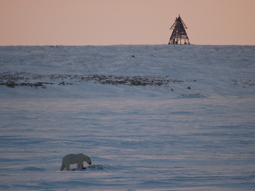
Mys Florensa (Bystryy Beacon)
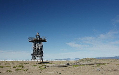
Date unknown. Inactive and abandoned. Approx. 5 m (17 ft) square pyramidal wood skeletal tower carrying a slatted daymark. One of Harry Shave's photos is at right, he also has a second photo, and Google has a satellite view. Located on a headland on the northwestern coast of Wrangel Island. Site open, tower closed.
Mys Florensa Light
Mys Florensa Light, Wrangel Island, August 2011
ex-Panoramio photo copyright Harry Shave; used by permission
Chukchi Sea Lighthouses
Okhotnichiy
Date unknown. Active (?); focal plane 12 m (39 ft); white flash every 6 s. 11 m (36 ft) square pyramidal skeletal tower, painted black. No photo available and Google has only a distant satellite view of the area. Located on a long barrier island about 40 km (25 mi) southeast of the abandoned mining town of Leningradskiy. Site status unknown. Admiralty L9857; NGA 17743.
Pil'gyn
Date unknown. Active (?); focal plane 18 m (59 ft); white flash every 3 s. 15 m (43 ft) square pyramidal skeletal tower, painted black with a white vertical stripe. No photo available and Google has only a distant satellite view of the area. Located on a 50 km (30 mi) long barrier island about 125 km (75 mi) southeast of Mys Enmykay. Site status unknown. RU 2111-9155; Admiralty L9886; NGA 17758.
Dvukh Pilotov
Date unknown. Active (?); focal plane 15 m (49 ft); white flash every 6 s. 10 m (33 ft) square pyramidal skeletal tower, painted black with a white vertical stripe. No photo available and Google has only a distant satellite view of the area. Located near the village of Dal'stroy in the southeastern portion of a long barrier island. The island is called the Kosa Dvukh Pilotov (Two Pilots Spit) after two American pilots whose plane crashed nearby in 1929. Site status unknown. RU 2111-9160; Admiralty L9888; NGA 17760.
Nutevgi (Nutaugye)
Date unknown. Active (?); focal plane 21 m (69 ft); white flash every 10 s. 10 m (33 ft) square black skeletal tower. No photo available and Google has only a distant satellite view of the area. Located on a barrier beach about 50 km (30 mi) northwest of Cape Vankarem. Site status unknown. RU 2111-9170; Admiralty L9890; NGA 17764.
Vankarem
Date unknown. Probably inactive. 12 m (39 ft) skeletal tower mounted on the roof of a dwelling. The light is in the foreground of an aerial photo, a 1975 photo is available, and Google has a distant satellite view. This light was apparently replaced by the Mys Vankarem Light (next entry). Located in the Chukchi village of Vankarem. Site status unknown.
Mys Vankarem
Date unknown. Active (?); focal plane 30 m (102 ft); white flash every 10 s. 10 m (33 ft) square black skeletal tower carrying a triangular slatted daymark. A photo is at right, the light is at the right edge of Wikimedia's photo, and the tower is visible in the distance in an aerial photo, but Google has only a fuzzy satellite view. Located at the point of the cape, northeast of the village of Vankarem. Site open, tower closed. RU 2111-9185; Admiralty L9892; NGA 17768.
Mys Vankarem Light
Mys Vankarem Light, Iultinskiy District
photo copyright RussiaDiscovery.ru; permission requested
Ostrov Kolyuchin (1)
Date unknown. Inactive. Light mounted on the roof of a 1-1/2 story polar weather station building. Building painted yellow; the roof is gray. Harry Shave's photo is at the top of this page and additional photos (last two thumbnails) are available, but Google has only a very fuzzy satellite view of the island. Kolyuchin Island is about 4.5 km (2.8 mi) long and 11 km (7 mi) off the coast, about 65 km (40 mi) southeast of Cape Vankarem. The island is uninhabited; both the weather station and a small Chukchi village have been abandoned. Located near the north end of the island. Accessible only by boat. Site open, buildings closed.
Ostrov Kolyuchin (2)
Date unknown. Inactive. Approx. 14 m (46 ft) square pyramidal skeletal tower. The light is to the right in Harry Shave's photo and two additional photos (thumbnails 9 and 12) are available. Located close to the original lighthouse. Accessible only by boat. Site open, buildings closed.

Chukotsky District Lighthouses

Chukchi Sea Lighthouses
Belyaka
Date unknown. Appears inactive. Approx. 11 m (36 ft) square wood skeletal tower with a platform. A photo by Dave Wiltzius is at right but Google has only a distant satellite view of the location. Located at the end of the Belyaka Spit, marking the east side of the narrow entrance to Koluchin Bay, an embayment about 100 km (62 mi) long and up to 37 km (23 mi) wide. Site status unknown. Admiralty L9898.
Mys Dzhenretlen
Date unknown. Active (?); focal plane 37 m (121 ft); white flash every 4 s. 10 m (33 ft) square skeletal tower carrying a daymark painted white with a black vertical stripe. No photo available and Google has only a fuzzy satellite view of the cape. Located on a cape about 65 km (40 mi) southeast of Kolyuchin Island. Site status unknown. RU 2111-9220; Admiralty L9900; NGA 17780.

Belyaka Light, Kolyuchin Bay, August 2016
photo copyright Dave Wiltzius; used by permission
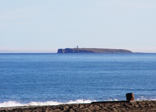
Ostrov Idlidlya
Date unknown. Active (?); focal plane 29 m (95 ft); white flash every 6 s. 12 m (39 ft) square skeletal tower carrying a daymark painted black with a white vertical stripe. A distant view from the mainland is at right and Google has a satellite view. Located on the western end of a small island about 50 km (30 mi) east of Mys Dzhenretlen. Site status unknown. RU 2111-9230; Admiralty L9910; NGA 17784.
Mys Ikigur
Date unknown. Active (?); focal plane 175 m (574 ft); white flash every 5 s. 4 m (13 ft) pyramidla wood tower painted white with an orange vertical stripe. No photo available and Google has only a fuzzy satellite view of the area. Located on a very steep headland about 160 km (250 mi) northwest of the Bering Strait entrance. Site status unknown. RU 2111-9255; Admiralty L9915; NGA 17791.
Chegitun
Date unknown. Active (?); focal plane 48 m (157 ft); white flash every 6 s. 12 m (39 ft) square metal skeletal tower. No photo available and Google has only a fuzzy satellite view of the area. Located on heights near the mouth of the Chegitun River, about 120 km (75 mi) northwest of the Bering Strait entrance. Site status unknown. RU 2111-9270; Admiralty L9920; NGA 17793.
Inin
Date unknown. Active (?); focal plane 94 m (309 ft); white flash every 4 s. 14 m (46 ft) square pyramidal skeletal tower. No photo available; Google has a distant satellite view that may show the light. Located on an isolated peak about 80 km (50 mi) northwest of the Bering Strait entrance. Site status unknown. RU 2111-9300; Admiralty L9925; NGA 17796.

Information available on lost lighthouses:

Notable faux lighthouses:

Ostrov Idlidlya Light
Ostrov Idlidlya Light, Chukchi Sea, seen from the mainland
Chukotsky District government photo

Adjoining pages: East: Alaska | South: Eastern Chukotka | West: Sakha Republic

Return to the Lighthouse Directory index | Ratings key

Posted May 19, 2006. Checked and revised June 15, 2024. Lighthouses: 49. Site copyright 2024 Russ Rowlett and the University of North Carolina at Chapel Hill.