Lighthouses of Saint Helena, Ascension and Tristan da Cunha

Saint Helena, Ascension and Tristan da Cunha is a British overseas territory linking three widely separated island groups in the South Atlantic Ocean. Ascension Island and Saint Helena are isolated volcanic islands, both in the tropical mid-Atlantic but separated by about 1300 km (810 mi). Tristan da Cunha is a small island group 2430 km (1510 mi) south of St. Helena. The total population of all these islands is less than 6000. In 2009 a new constitution established separate administrations for the three regions but the three together are still considered a single overseas territory.

Properly speaking there are no lighthouses in these islands, but there are a number of navigation lights.

Admiralty numbers are from volume D of the Admiralty List of Lights & Fog Signals. U.S. NGA List numbers are from Publication 113. ARLHS has no listings for these islands.

General Sources
World of Lighthouses - British Territories in Atlantic
Photos available from Lightphotos.net.
Online List of Lights - St. Helena, Ascension, and Tristan da Cunha
Photos by various photographers posted by Alexander Trabas.
Navionics Charts - Ascension and Saint Helena
Navigation charts for the islands.


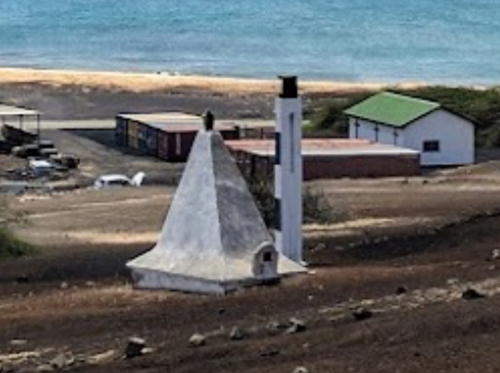
Clarence Bay Entrance Range Front Light, Ascension Island, September 2017
Google Maps photo by Declan Fyans

Ascension Island Lightbeacons
* [Clarence Bay Entrance Range Front]
Date unknown. Active (shown only when a ship is arriving); focal plane 27 m (89 ft); continuous green light. 5 m (17 ft) square concrete pillar, painted with black and white horizontal bands. Declan Fyans has the 2017 photo seen above and the pillar appears as a white dot in the center of Google's satellite view. The square white pyramid seen in the photo above serves as a daymark; it also marks the grave of Capt. Paisley, the commander of the brig HMS Redpole, who died on the island in 1820, five years after Britain occupied the previously-uninhabited island. Clarence Bay is not really an embayment; it is the partially-protected anchorage off Georgetown, on the northwest coast of the island. Located on the hillside east of the town. Site open. Admiralty D4800; NGA 26072.
* [Clarence Bay Entrance Range Rear]
Date unknown. Active (shown only when a ship is arriving); focal plane 35 m (115 ft); continuous green light. 5 m (17 ft) square concrete pillar, painted with black and white horizontal bands. The pillar appears as a white dot in the center of Google's satellite view. Located beside a road, 61 m (200 ft) uphill (southeast) of the front light. Site open. Admiralty D4800.1; NGA 26076.
* [Ascension Harbor Range Rear]
Date unknown. Active; focal plane 55.5 m (182 ft); continuous white light. 27.5 m (90 ft) mast painted with red and white horizontal bands. No photo available and the mast is barely visible in Google's satellite view. The front light is on a similar mast 19.5 m (60 ft) tall a short distance to the southwest. Located next to a radar facility north of Clarence Bay. Site open, tower closed. Admiralty D4804.1; NGA 26084.

Saint Helena Lightbeacons
* [Ladder Hill Range Rear]
Date unknown. Active (shown only when a ship is arriving); focal plane 170 m (558 ft); green light, 4 s on, 4 s off. 2 m (7 ft) skeletal mast, painted white, mounted at a corner of a stone wall. Kyle Williamson has a street view and Google has a satellite view of the station. Jamestown, the principal settlement of Saint Helena, is built in narrow valley notched into the precipitous northwestern coast of the island. Ladder Hill, on the south side of town, is connected to town by one of the world's longest stairways, known as Jacob's Ladder. The front light (green flash every 3 s) is on a similar skeletal mast at a focal plane of 143 m (469 ft); it can be seen a little above and to the left of the center of a photo of the range. Located at the top of Jacob's Ladder. Site open. Admiralty D4904.1; NGA 26104.
[Chubbs Point]
Date unknown. Active; focal plane 25 m (82 ft); two red flashes every 10 s. Described by NGA only as a beacon. No photo available but Kyle Williamson's street view shows the small beacon on the steep slope above the pier. Google has an indistinct satellite view. Site status unknown. Admiralty D4906; NGA 26108.

Information available on lost lighthouses:

Notable faux lighthouses:

Adjoining pages: South: Falkland Islands | West: Brazil's Atlantic Islands

Return to the Lighthouse Directory index | Ratings key

Created November 13, 2013. Checked and revised July 14, 2024. Lighthouses: 0. Site copyright 2024 Russ Rowlett and the University of North Carolina at Chapel Hill.