Lighthouses of Somalia

Shaped something like a fish hook, the Federal Republic of Somalia is located on the Horn of Africa, the northeastern corner of the continent. The country was formed in 1960 by uniting the former British Somaililand, which faces north on the Gulf of Aden, with the former Italian Somaliland, which mostly faces east southeast on the Indian Ocean.

This union has never been complete and since 1991 the country has been splintered by repeated warfare. The Republic of Somaliland, which controls most of the former British Somaliland, declared its independence of Somalia in 1991 and has been seeking international recognition. Lighthouses of Somaliland are described on a separate page.

For the rest of the country the Federal Government of Somalia is recognized by the United Nations and is attempting to create a federal state, but much of the country has been in the hands of various warlords or the Islamist Al Shahaab movement. In 2016 Somalia was officially declared to be a federation of five states (six if Somaliland should ever join the federation) plus the capital region of Benadir. The northern states of Galmudug and Puntland and the southern state of Jubaland have autonomous governments which say they are willing to be considered states within a federal Somalia.

Under these unsettled and dangerous conditions it is very difficult to determine the status of the lighthouses. The lighthouses in Somaliland and some lighthouses in Puntland are apparently operating but the other Somali lighthouses are probably abandoned and falling into ruin. Current information on any of these sites would certainly be welcome.

Somali and Arabic are official languages in Somalia. Unlike Arabic, Somali is written in the Latin alphabet. The Somali word for a lighthouse is laydh; jasiirad is an island and dekedda is a harbor.

ARLHS numbers are from the ARLHS World List of Lights. Admiralty numbers are from volume D of the Admiralty List of Lights & Fog Signals. U.S. NGA List numbers are from Publication 112.

General Sources
Online List of Lights - Somalia
Photos by various photographers posted by Alexander Trabas.
Lighthouses in Somalia
Photos by various photographers available from Wikimedia.
World of Lighthouses - Somalia
Photos by various photographers available from Lightphotos.net.
Afrikanischen Leuchttürme auf historischen Postkarten
Historic postcard images posted by Klaus Huelse.
Lighthouses of Africa
Historic postcard images posted by Michel Forand.
Navionics Charts
Navigation chart covering the Puntland area.


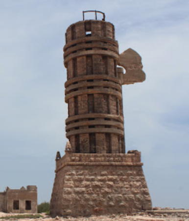
Ra's Asir (Cape Guardafui) Light, March 2013
ex-Panoramio photo copyright Oscar de Vogel; used by permission

Puntland Lighthouses
Puntland is a state at the northeastern corner of Somalia that declared itself autonomous, though not independent, in 1998. In 2017 the Dubai-based company DP World signed an agreement to develop the region's principal port Bosaso (formerly Bandar Qasim) on the Gulf of Aden. Puntland has been the most stable region of Somalia in recent years, acting in many respects as an independent state.
* Bosaso (Bossaso, Boosaaso, Bandar Cassim, Bandar Qasim) Range Rear (1)
Date unknown. Apparently inactive since 2004. 13 m (43 ft) black and white banded tower. No lantern. Lightphotos.net has a view of the light and Google has a satellite view. An Admiralty Notice to Mariners (2004#22) reported that the Bosaso range lights had been replaced by new lights on a slightly different heading, but that the old structures were left in place. The new rear light (red light, 2 s on, 2 s off) was described by another Admiralty notice in 2008 as being on a "white post," height not listed, with a red diamond daymark.; it is located closer to the waterfront. Located in Bosaso. Site open, tower closed. ARLHS SOM-001. Active light: Admiralty D7260.1; NGA 31060.
Qandala (Candala) (?)
Date unknown. Inactive but listed with focal plane unknown; three long white flashes every 30 s. Described by the light lists as "residency." Omar Gadood has a 2019 view from the sea and a closeup of what is probably the "residency" building, but there's no evidence of a light. Google has a satellite view. Located on the waterfront at Qandala, a village about 75 km (47 mi) east of Bosaso. Site open, tower closed. Admiralty D7258; NGA 31064.
Alula (Caluula)
Date unknown. Inactive but listed with focal plane 16 m (52 ft); two white flashes every 16 s. 13 m (43 ft) square cylindrical white concrete tower, unpainted. A photo is at right, Omar Dr Abdulkadir has a 2019 photo, and Google has a satellite view. There's no evidence of an active port here. Alula is a short distance southwest of Cape Alula, the northernmost point of Somalia. Located on the waterfront at Alula, a village about 50 km (30 mi) west of Cape Guardafui. Site open, tower closed. Admiralty D7256; NGA 31068.

Caluula (Alula) Light
unattributed photo posted to Twitter by @Soomaalikabe‏ on 16 March 2017
Ra's Caseyr (Ra's Asir, Cape Guardafui, Faro Francesco Crispi) (2)
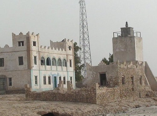
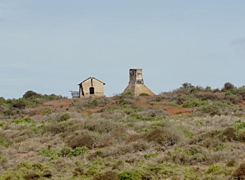
1930 (station established 1924). Inactive and abandoned. 19 m (63 ft) round cylindrical masonry tower, originally with lantern and gallery, mounted on a square stone base. Oscar de Vogel's photo is at the top of this page, Alberto Alpozzi has a photo, Heimo Liendl has a 2016 closeup photo, another 2016 photo is available, Abdul Warfa has a 2017 photo, and the shadow of the tower and remains of several buildings can be seen in Google's satellite view of the station. Wikimedia has a historic photo of the intact lighthouse; the lantern is now gone and the abandoned buildings are in ruins. Forand has a historic postcard view of the original lighthouse, a skeletal tower. Cape Guardafui, also called Ra's Caseyr or Ra's Asir, is the point of the Horn of Africa, the northeastern tip of the continent. This historic lighthouse is described by the international light lists as "unreliable"; in fact it has been abandoned and the surrounding area is quite desolate. It had a focal plane of 263 m (863 ft) making it one of Africa's highest lighthouses. It was designed to resemble a fasces, the symbol of the fascist Italian government; it even has the axe blade on its side. The lighthouse was originally named for Francesco Crespi, who served two terms as Prime Minister of Italy between 1887 and 1896. Site status unknown. ARLHS SOM-003; Admiralty D7246; NGA 31072.
Ra's Hafun (Xaafuun)
Date unknown. Inactive; listed with focal plane 107 m (351 ft), two white flashes every 35 s. 13 m (42 ft) concrete post centered on a square concrete building. Lightphotos.net has a photo, a 2010 photo is available, and the abandoned station is seen in a Google satellite view. Ra's Hafun, the easternmost point of the African continent, is a sharp promontory sheltering the fishing port of Hafun. Puntland plans some economic development of Hafun, so the light might be reactivated. Site status unknown. ARLHS SOM-011; Admiralty D7242; NGA 31076.
Bayla (Bandarbeyla)
Date unknown. Inactive; listed with focal plane unknown and a continuous white light. Approx. 12 m (39 ft) square cylindrical masonry tower. The tower is seen clearly in Axmed Diini's 2019 drone view of the town and Google has a satellite view. Located at the north end of Bayla, a district capital sheltered by the cape of Ra's Ma'bar about 120 km (75 mi) south of Ra's Hafun. Site status unknown. Admiralty D7239; NGA 31080.

Galmudug Lighthouse
Galmudug is a state in central Somalia formed in 2006. It includes the region of Galgaduud and the southern portion of Mudug, a region that has been effectively partitioned with the northern portion administered by Puntland. In 2011 Galmudug and Puntland signed an agreement to work together on security and economic issues and to fix the border between them.

Hobyo (Obbia)
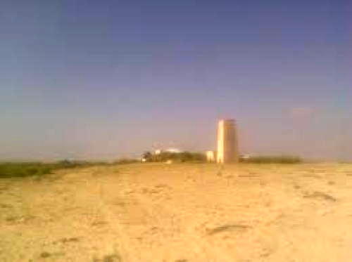
Date unknown. Inactive; listed with focal plane 32 m (105 ft); three white flashes every 10 s. 10 m (33 ft) square cylindrical tower, originally painted with black and white horizontal bands. A fuzzy photo is at right and Google has a satellite view. Note: there are several "Obbia lighthouse" photos on the Internet that show misidentified towers. Located in Hobyo, a small town about 500 km (315 mi) northeast of Mogadishu. The town has no regular port facilities, only a small, partially-protected anchorage. Site status unknown. ARLHS SOM-008; Admiralty D7236; NGA 31088.

Hobyo Light
unattributed ex-Panoramio photo no longer online but found in a Google Images search

Hirshabelle (Middle Shabelle) Lighthouse
Hirshabelle is a state in south central Somalia formed theoretically in 2016 by combining the coastal region of Middle Shabelle with the inland region of Hiran. Both regions would prefer to be autonomous so the state government has been ineffective.

Adale (Cadale) (?)
Date unknown. Inactive; listed with focal plane 12 m (39 ft); white flash every 3 s. Short skeletal tower mounted on the east corner of a "residence." No photo available and no light is seen in an aerial view of the town. Google has a satellite view of the listed location. Adale or Cadale is a town about 150 km (95 mi) northeast of Mogadishu. The town has no regular port facilities. Site status unknown. Admiralty D7230; NGA 31092.

Mogadishu (Benadir Region) Lighthouse
Mogadishu, the national capital and former capital of Italian Somaliland, is a large city with a population estimated to be about 2.4 million. It is generally under the control of the Federal Government, which had driven out Al Shahaab forces by the end of 2011. The Mogadishu Port Authority operates the country's largest port.

Moqdishu (Mogadishu) Main (2?)
Date unknown (station established 1903). Inactive; listed with focal plane 74 m (243 ft), white flash every 12.5 s. Described by current light lists as a 10 m (33 ft) white masonry tower with a focal plane of 74 m (243 ft). Originally, this was a 17 m square tower with lantern and gallery. No current photo available. The library of the Swiss Institute of Technology has the 1912 photo at right, a more distant historic view (lighthouse at lower left) is available, and Google has a satellite view. The history of this building is unknown, but the present tower appears to be the same as the one in the 1912 photo. The historic lighthouse is located on a ridge about 1.5 km (1 mi) northwest of the harbor. Site status unknown. ARLHS SOM-007; Admiralty D7218; NGA 31096.
Mogadishu First Range (Betel Raz Range) Front
Date unknown. Active; focal plane 15 m (49 ft); continuous red light. 15 m (49 ft) square tower painted with black and white horizontal bands. No photo available but Google has a satellite view. This is the approach range for the port. The rear light, a smaller tower, is atop a building 180 m (200 yd) northwest. Located on the waterfront east of the port entrance. Site status unknown. Admiralty D7220; NGA 31100.
Mogadishu Main Light
Mogadishu Main Light, 1912
ETH Zurich Creative Commons image

South West State (Lower Shabelle) Lighthouses
The South West State was established by the Federal Government in 2009 but it exists largely in theory; much of its territory has been controlled by Al Shaahab forces.

Merka (Merca, Marka) Range Rear (2?)
Date unknown (station established 1912). Inactive. 17 m (56 ft) white round concrete tower. Forand has a historic postcard view, and Google has a distant satellite view. Huelse has a different postcard view showing a skeletal concrete tower. Merca is a town 109 km (68 mi) southwest of Mogadishu. The front light is on a post near the shore. The area was controlled by Al Shahaab for several years but it was recaptured by the Transitional Government in August 2012. Al Shahaab reoccupied the town briefly in 2016. Merca has no protected harbor, only an open roadstead. Note: accurate information on the history of this range is lacking, and this has led to considerable confusion. A black and white banded tower seen in a Lightphotos.net photo and many other photos is widely interpreted as a range lighthouse but this seems unlikely. Located on the west side of Merka, above the roadstead. Site status unknown. ARLHS SOM-006.
Merka (Merca, Marka) Range Rear (3?)
Date unknown (station established 1912). Active (?); focal plane 35 m (115 ft); white light, 2 s on, 6.5 s off. 17 m (56 ft) round white concrete tower. No photo available but the tower is possibly centered in Bing's satellite view. Located in the city about 400 m (1/4 mi) north of the historic lighthouse. Site status unknown. Admiralty D7212.1; NGA 31140.
Barawa (Baraawa, Brava)
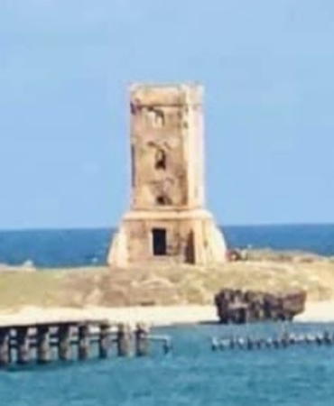
1912. Inactive. Approx. 18 m (56 ft) square concrete tower with gallery; the lantern has vanished. Abtüllah Ömers 2023 photo is at right, Muhamed Ahmed Nahdei has a 2021 photo, Ibrahim Xasan has a 2017 distant view, Saalah Baana has a fuzzy photo, Abdullahi Kassim has a 1983 photo, Huelse has a historic postcard view of the lighthouse when it was active, and Google has a satellite view. Obviously endangered. Barawa was under Al Shahaab's control from 2009 to 2014 and functioned as the group's capital. The central government's control remains precarious in this area. Located on an island sheltering the harbor of Barawa, a port about 160 km (100 mi) southwest of Mogadishu. Accessible only by boat. Site status unknown. ARLHS SOM-002.

Barawa Light, Barawa, January 2023
Google Maps photo by Abtüllah Ömer

Jubaland Lighthouses
Jubaland is a state at the southwestern corner of Somalia. Much of Jubaland was formerly claimed by Britain as part of Kenya but Britain ceded its claims to Italy in 1924. The region had been controlled by Al Shahaab but in 2010 a new administration took power, with Kenyan support, and declared the region to be an autonomous state similar to Puntland. The Jubaland administration and the transitional government in Mogadishu reached an agreement in August 2013 recognizing the autonomous status of the territory. The Port of Kismayo has a checkered history; orginally built with U.S. assistance it served in the 1970s as a base for the Soviet Navy. It remains very active today.
Juba River (Fiume Giuba)
1912(?). Inactive. 9 m (30 ft) black square masonry tower on white truncated pyramid. No photo available. Marcus Koehne contributed the 2019 photo seen at right and the station is shown in a Bing satellite view. Located at the mouth of the Juba River about 16 km (10 mi) northeast of Kismayo (Kismayu). Site status unknown. ARLHS SOM-004; Admiralty D6852; NGA 31156.
Passo Nord Range Front
Date unknown. Active(?); focal plane unknown; green light occulting once every 2 s. Approx. 5 m (17 ft) round concrete tower painted with black and white horizontal bands. No photo available but Google has a satellite view. This is an approach range for Kismayo. Located on the northern tip of Seerbenti island at Kismayo. Site status unknown. Admiralty D6842.9; NGA 31161.
Passo Nord (Range Front)
Date unknown. Active(?); focal plane about 17 m (56 ft); green light occulting onec every 2 s. Approx. 10 m (33 ft) white tower. Ali Yusuf has a very distant view and Google has a satellite view. The Kolina Rojoota Light, 9 km (5.75 mi) to the southwest, is the rear light of this approach range. Located on the nortern tip of the island of Tartaruuga (Isola dei Serpenti), about 1.5 km (1 mi) southeast of Kismayo (Kismayu); the island is connected to the mainland by a causeway. Site status unknown. Admiralty D6842.9; NGA 31161.
Isola dei Serpenti (Kismayu, Kismayo, Seerbenti)
Date unknown. Apparently in ruins but listed with focal plane 35 m (115 ft); white flash every 4 s, also a continuous red light of shorter range. Approx. 20 m (66 ft) round masonry tower centered on a masonry keeper's house. No photo available. The lighthouse appears ruined in Google's satellite view. The regional capital of Kismayo is a city of about 90,000 residents. The city has an active harbor but the satellite view shows no evidence of activity around the light station. Located on an island Site status unknown. ARLHS SOM-010; Admiralty D6842; NGA 31160.

Juba River Light, May 2019
photo copyright Marcus Koehne; used by permission
Passo Interno Range Front
Date unknown. Active(?); focal plane unknown; green light occulting once every 2 s. Approx. 5 m (17 ft) round concrete tower painted with black and white horizontal bands. No photo available but Google has a satellite view. This is an approach range for the harbor sheltered by Seerbenti island. Located on a hillside on the minland northwest of the historic lighthouse. Site status unknown. Admiralty D6844; NGA 31163.
Passo Interno Range Rear
Date unknown. Active(?); focal plane 27 m (89 ft); quick-flashing green light. Approx. 10 m (33 ft) round concrete tower painted with black and white horizontal bands. No photo available but Google has a satellite view. Located 360 m (1/4 mi) northwest of the front light. Site status unknown. Admiralty D6844.1; NGA 31163.1.
Passo di Levante Range Front
Date unknown. Active(?); focal plane unknown; green light occulting once every 2 s. Approx. 5 m (17 ft) triangular concrete tower painted with black and white horizontal bands. No photo available but Google has a satellite view. This is an approach range for Kismayo. Located in a deserted area about 8 km (5 mi) southwest of Kismayo. Site status unknown. Admiralty D6843.1; NGA 31162.
Kolina Rojoota (Kismayo Common Range Rear)
Date unknown. Active(?); focal plane unknown; quick-flashing green light. Approx. 10 m (33 ft) triangular concrete tower painted with black and white horizontal bands. No photo available but Google has a satellite view. Located in a deserted area about 8 km (5 mi) southwest of Kismayo. Site status unknown. Admiralty D6843; NGA 31161.5.

Information available on lost lighthouses:

Notable faux lighthouses:

Adjoining pages: South: Kenya | West: Somaliland

Return to the Lighthouse Directory index | Ratings key

Posted July 1, 2005. Checked and revised December 5, 2023. Lighthouses: 21. Site copyright 2023 Russ Rowlett and the University of North Carolina at Chapel Hill.