Lighthouses of São Tomé and Príncipe

The Democratic Republic of São Tomé and Príncipe includes two small volcanic islands off the west coast of equatorial Africa, part of a chain of volcanos that begins on the mainland in Cameroon and also includes the islands of Bioko and Annobón in Equatorial Guinea. The islands were uninhabited until they were discovered by Portuguese navigators in the late 1400s. They continued to be Portuguese colonies until 1975, when they became an independent nation.

The population of the islands is about 220,000. Most live on São Tomé, the larger of the islands.

In the 1990s the navigational service of the Portuguese Navy helped São Tomé and Príncipe create a system of modern navigational aids to guard the rocky coasts of the islands. Most of the aids are concrete post lights. Listed here are those aids that might qualify as lighthouses plus those that replaced traditional lighthouses. Much of the information on the page comes from a former Portuguese Navy web page. Special thanks to Michel Forand for finding this resource and to Walt Hempel for rediscovering it after the Navy moved it to different server. Unfortunately the page has now disappeared.

Portuguese continues as the language of government and trade in São Tomé and Príncipe, along with three indigenous languages. The Portuguese word for a lighthouse is farol, plural faróis; a small lightbeacon is often called a farolim. In Portuguese ilha is an island, ilhéu is an islet, cabo is a cape, ponta is a promontory or point of land, rocha is a rock, recife is a reef, baía is a bay, estreito is a strait, rio is a river, and porto is a port or harbor.

Aids to navigation in the islands are probably the responsibility of the port authority, the Empresa Nacional de Administração dos Portos (ENAPORT).

ARLHS numbers are from the ARLHS World List of Lights. PT numbers are from the Portuguese Navy list, as recorded by the Portuguese Wikipedia. Admiralty numbers are from volume D of the Admiralty List of Lights & Fog Signals. U.S. NGA List numbers are from Publication 113.

General Sources
Lighthouses in São Tomé e Principe
Photos by various photographers available from Wikimedia.
World of Lighthouses - São Tomé and Principe
Photos by various photographers available from Lightphotos.net.
Online List of Lights - São Tomé and Príncipe
Photos by various photographers posted by Alexander Trabas.
Lista de Faroís - São Tomé e Príncipe
Index of the lights in the Portuguese edition of Wikipedia.
Afrikanische Leuchttürme auf historischen Postkarten
Postcards from the collection of Klaus Huelse.
Navionics Charts
Navigation chart for the islands.

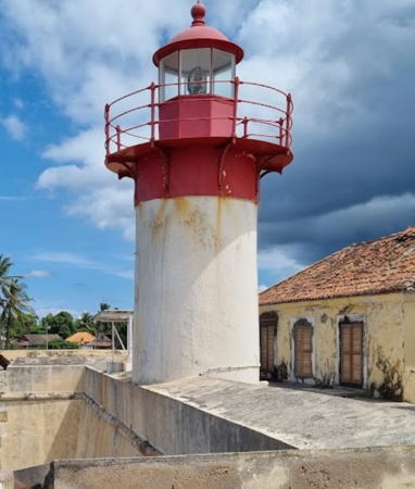
São Sebastião Light, São Tomé, JApril 2022
Google Maps photo by L. T.
Príncipe Lighthouses
Príncipe is a relatively small island, the eroded top of an ancient volcano. The island is about 22 km (13 mi) long and has a population of about 8500. Santo António is the only settlement of any size.
[Ilhéu Bom Bom (2)]
1997 (station established 1928). Active; focal plane 64 m (210 ft); two flashes every 10 s, white or red depending on direction. 3.5 m (12 ft) cross-shaped concrete post, painted with red and white horizontal bands. No photo available but Google has a satellite view. The original lighthouse was a square cast iron tower. Located atop a small islet off the northern tip of Príncipe. Accessible only by boat. Site open, tower closed. ARLHS SAO-005; PT-4006; Admiralty D4158; NGA 25180.
* [Pónta da Mina (2)]
1996 (station established 1897). Active; focal plane 54 m (177 ft); two white flashes every 6 s. 5 m (16 ft) cross-shaped concrete post, painted with red and white horizontal bands. The light is seen in a video by Emiterilsom Lavres but the small light is hidden by the forest in Google's satellite view. The original lighthouse was a cast iron tower mounted on a wall of the ruined Santa Ana Fortaleza de Pónta Mina, built in 1695 to protect the Portuguese settlement on the island. Located on a headland on the south side of the entrance to the harbor of Santo António, the largest town of Príncipe. Site open, tower closed. ARLHS SAO-013; PT-4003; Admiralty D4154; NGA 25172.
* Santo António do Príncipe
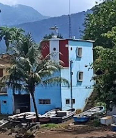
1964. Active; focal plane 13 m (43 ft); three white flashes every 10 s, white, red, or green depending on direction. 12 m (39 ft) square masonry tower, rising from the harbormaster's office. Tower painted with red and white vertical stripes; the rest of the building is painted light blue. A 2023 photo is at right, the light is at the right in Chris Kean's photo of the waterfront and also in Sofia Azevedo's 2018 photo, Lightphotos.net has a small photo, and Google has a satellite view. Located at the west end of the waterfront in Santo António, the principal settlement on the island. Site open, tower status unknown. ARLHS SAO-015; PT-4002; Admiralty D4155; NGA 25176.
[Boné do Jóquei (Ilhéu Caroço)]
Date unknown. Active; focal plane 29 m (95 ft); three white flashes every 12 s. 5 m (16 ft) square tower painted with red and white horizontal bands. Trabas has Bjørn Poulsen's photo Google has a fuzzy satellite view. Located on Boné do Jóquei, a small island southwest of Ilhéu Caroço, a somewhat larger island off the southern tip of Príncipe. Accessible only by boat. Site status unknown. PT-4008; Admiralty D4159; NGA 25174.5.
[Tinhosa Grande)]
Date unknown. Active; focal plane 60 m (197 ft); two flashes every 15 s, white or red depending on direction. 5 m (16 ft) square tower painted with red and white horizontal bands. No photo available and clouds partially obscure Bing's satellite view of the island. Located on Tinhosa Grande, the southernmost of a chain of small islands about 20 km (13 mi) southwest of the southern tip of Príncipe. Accessible only by boat. Site status unknown. PT-4010; Admiralty D4160; NGA 25182.


Santo António do Príncipe Light, March 2023
Google Maps photo by Alexis S


São Tomé Lighthouses
The island of São Tomé is roughly elliptical, 48 km (30 mi) long and 32 km (20 mi) wide, located in the Gulf of Guinea about 240 km (150 mi) due west of Port Gentil, Gabon. São Tomé city, the national capital, is located on Ana Chaves Bay on the northeast side of the island.

* [Lagoa Azul]
1997. Active; focal plane 34 m (112 ft); two white flashes every 15 s. 7 m (23 ft) cast iron tower with lantern and gallery. 5 m (16 ft) cross-shaped concrete post, painted with red and white horizontal bands. Inna Moody has a 2007 photo, José Miranda has a 2016 photo, Anthony Asael has a distant view, and Google has a satellite view. Lagoa Azul (blue lagoon) is a small cove sheltered by the cape on which the light stands. Located on on a promontory at the northwestern tip of the island of São Tomé. Accessible by road. Site open, tower closed. ARLHS SAO-010; PT-4055; Admiralty D4243; NGA 25183.
Ilhéu das Cabras
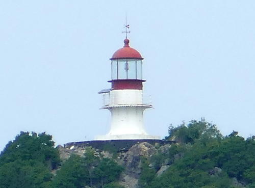
1890. Active; focal plane 97 m (318 ft); three white flashes in a 2+1 pattern every 15 s. 7 m (23 ft) cast iron tower with lantern and gallery. Tower painted white, lantern red. A 2019 photo is at right, the light is visible in André Pipa's aerial view, there's a photo (2/3 the way down the page) of the steep stone stairway leading to the lighthouse, Huelse has a historic postcard view, and Google has a satellite view. This handsome little lighthouse was nicely restored by the Portuguese navy in 1994. Located on the summit of a small island just off the northern tip of the island of São Tomé. Accessible only by boat. Site open, tower closed. ARLHS SAO-007; PT-4030; Admiralty D4230; NGA 25184.

Ilhéu das Cabras Light, São Tomé, January 2019
Wikimedia Creative Commons photo by Ji-Elle
* [Ana Chaves Posterior (2)]
1994 (station established 1952). Active; focal plane 37 m (121 ft); green light, 2 s on, 2 s off. 5 m (16 ft) cross-shaped concrete post, painted with red and white horizontal bands. Google has a street view and a distant satellite view. The front light is on a similar, smaller tower about 80 m (90 yd) down the hillside. Located on the west side of the entrance to the Baia de Ana Chaves, the harbor of the national capital São Tomé. Site open, tower closed. ARLHS SAO-003; PT-4034.1; Admiralty D4234.1; NGA 25200.
*** São Sebastião (2)
1928 (station established 1866). Active; focal plane 13 m (43 ft); four flashes every 12 s, white or red depending on direction. 6 m (20 ft) tower with lantern and gallery mounted atop the Fortaleza de São Sebastião. Tower and fort painted white, lantern red. Access to the gallery is by an external ladder. A 2022 photo is at the top of this page, Inna Moody has a closeup photo and a 2006 photo of the fort and lighthouse, Bruce Potter has a 2007 closeup, Lightphotos.net has a 2013 photo, Trabas has Douglas Cameron's view from the sea, Michel Forand has a historic postcard view, Huelse has a different postcard view, and Google has a satellite view. The historic fortress is now the national museum of history and art. The lighthouse was restored in 1994. Located on a point of land on the east side of the Baia de Ana Chaves in São Tomé. Site open, and visitors can easily climb to the gallery. Site manager: Museu Nacional de São Tomé e Príncipe. ARLHS SAO-002; PT-4038; Admiralty D4237; NGA 25192.
Ilhéu Gago Coutinho (Ilhéu das Rolas)
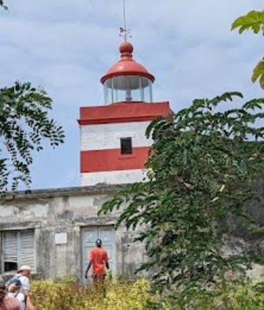
1929. Active; focal plane 106 m (348 ft); two white flashes every 10 s. 9 m (30 ft) square cylindrical masonry tower with lantern and gallery, rising from a 1-story keeper's house. Building painted white, lantern red. Florian Bro's 2022 photo is at right, a 2014 photo is available, and Google has a satellite view. The lighthouse was restored in 1994. Located on heights on the south side of the Ilhéu das Rolas, a small island off the southern tip of the island of São Tomé; the island is named for Gago Coutinho, a Portuguese geologist who proved that the Equator bisects the island (the lighthouse is about 500 m (0.3 mi) south of the Equator). Accessible only by boat. Site open, tower apparently open. ARLHS SAO-009; PT-4042; Admiralty D4241; NGA 25204.

Information available on lost lighthouses:

Notable faux lighthouses:


Ilhéu Gago Coutinho Light, Ilhéu das Rolas, July 2022
Google Maps photo by Florian Bro

Adjoining pages: North: Equatorial Guinea | East: Gabon

Return to the Lighthouse Directory index | Ratings key

Posted September 16, 2005. Checked and revised March 23, 2024. Lighthouses: 4. Site copyright 2024 Russ Rowlett and the University of North Carolina at Chapel Hill.