Lighthouses of Norway: Svalbard

The Kingdom of Norway (Norge in Norwegian) is one of the world's most maritime nations. The country is long and narrow, with drowned valleys called fjords that bring the sea far inland in most regions. The mainland coast is estimated to be 2650 km (1650 mi) long and when all the islands and minor indentations are counted the total coastline approaches an astonishing 60,000 km (37,500 mi), long enough the go around the world one and a half times. With such a lengthy and rocky shore it's not surprising that Norway has a large number of lighthouses.

Svalbard is an archipelago in the Arctic Ocean roughly 800 km (500 mi) north of Norway's North Cape and a similar distance from the North Pole. Under the 1925 Svalbard Treaty the territory is part of the Kingdom of Norway but other countries have the right to exploit mineral resources (meaning coal). The only nation exercising this right is Russia, which has a mining settlement of about 600 residents at Barentsburg. The Norwegian town Longyearbyen, with a population of about 1800, is the northernmost town in the world. Both Barentsburg and Longyearbyen are on the Isfjord, which cuts across the main island from west to east.

Svalbard is governed as an unincorporated territory of Norway with a governor appointed by the national government. In recent years Svalbard has become accessible by adventure cruise ships.

All the lighthouses are on Spitsbergen, the largest island of the Svalbard archipelago. (Historically the entire territory was often called Spitsbergen.)

In Norwegian a lighthouse is a fyrtårn (fire tower) or simply a fyr; a fyrlykt is a beacon and a lyktehus is a lantern. Øy is an island, holmen is an islet, skjær is a skerry (a tiny island or rocky reef), sund is a strait (often between an island and the mainland), bukt is a bay, nes is a headland, and havn is a harbor.

Aids to navigation in Norway are maintained by the Kystverket (Coast Directorate), an agency of the Ministry of Transport and Communications.

ARLHS numbers are from the ARLHS World List of Lights. NF numbers are from the Norsk Fyrliste. Admiralty numbers are from volume L of the Admiralty List of Lights & Fog Signals. U.S. NGA List numbers are from Publication 115.

General Sources
Online List of Lights - Norway
Photos by various photographers posted by Alexander Trabas.
Lighthouses in Svalbard
Photos by various photographers available from Wikimedia.
World of Lighthouses - Svalbard
Photos by various photographers available from Lightphotos.net.
Norsk Fyrliste
The official Norwegian light list can be downloaded in six .pdf volumes.
GPSNavigationCharts
Navigation chart information for Svalbard.
Navionics Charts
Navigation chart for Svalbard.

Akseløya Fyr
Akseløya Light, Bellsund
Kystverket photo from 2011 Norsk Fyrliste


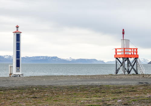
Old (right) and new Vestpynten Lights, Longyearbyen, July 2016
Wikimedia Creative Commons photo by Andrew Shiva

Southern Spitsbergen Lighthouses
Skjemmeneset (Sørkapp)
Date unknown. Active; focal plane 7 m (23 ft); white flash every 2 s. Approx. 5 m (17 ft) tower. No photo available but Google has an indistinct satellite view. Skjemmeneset is the southern tip of Spitsbergen island. Accessible only by boat. Site status unknown. NF-998500; Admiralty L4300.5.
Hornsund
Date unknown. Active (unofficial); white light. Post light attached to one corner of one of the buildings of the Polish Arctic Station. Wikimedia has a closeup photo and Google has a satellite view of the station. This light is not listed as an official aid to navigation but it obviously helps to guide vessels arriving at the station. Located on the north side of the Hornsund (Isbjørnhamn), a fjord entrance about 100 km (60 mi) south of Bellsund. Site open, tower closed.
Kapp Martin (Bellsund)
1946. Active; focal plane 18 m (59 ft); white flash every 3 s. 12 m (39 ft) square pyramidal skeletal tower with an enclosed upper portion. Lighthouse painted black, enclosure red. A white band mentioned by the Admiralty and by NGA is not seen in Manfred Bartels's photo. The light is at the far right in Jacek Drecki's photo and Google has a distant satellite view. Located on the cape on the north side of the entrance to the Bellsund, about 50 km (30 mi) south of Kapp Linné. Probably accessible only by boat. Site open, tower closed. ARLHS SVA-009; NF-995600; Admiralty L4302; NGA 17816.
Akseløya
Date unknown. Active; focal plane 15 m (49 ft); two white flashes every 10 s. 7 m (23 ft) square pyramidal skeletal tower with an enclosed upper portion. Lighthouse painted black, enclosure red. A Kystverket photo is at the top of this page, Manfred Bartels has a photo, a 2017 photo is available, and Bing has a distant satellite view. Akseløy is a long, narrow island that blocks most of the entrance to the Van Milenfjord from the Bellsund. Located at the northern point of the island. Accessible only by boat. Site open, tower closed. ARLHS SVA-006; NF-995800; Admiralty L4304; NGA 17820.
Blåhuken (2?)
Date unknown. Active; focal plane 8 m (26 ft); two white flashes every 10 s. Approx. 6 m (20 ft) square tower with a pyridal top. Tower painted white, top red. Polar Quest has Erik Edvardsson's photo (third photo on the page) and Google has a satellite view. NGA lists a skeletal tower. Located on a sharp promontory on the north side of the Van Mijenfjord. Accessible only by boat. Site status unknown. NF-996000; Admiralty L4306; NGA 17824.

Isfjord Lighthouses
Isfjord (Kapp Linné)
1933. Active; focal plane 21 m (69 ft); white flash every 10 s. 13 m (43 ft) square pyramidal skeletal tower with an enclosed upper portion. The original lantern has been removed and the light is now displayed from a short post mounted on the gallery. A closeup from Stian Fjeldstad's 2022 drone view is at right, Trabas has Rainer Arndt's photo, another photo is available, and Google has a satellite view. There is a historic radio station near the lighthouse and accommodations are available at the station. This is often considered to be the world's northernmost traditional lighthouse, standing in latitude 78°03.8' N, although the Vestpynten light and other small lights are farther north. Located on the point of the cape, marking the south side of the entrance to the Isfjord. Accessible only by boat or helicopter, or perhaps by snowmobile from Barentsburg. Site open, tower closed. ARLHS SVA-005; NF-986000; Admiralty L4314; NGA 17804.
[Festningen (2?)]
Date unknown. Active; focal plane 13 m (43 ft); white flash every 10 s. 3 m (10 ft) post attached to a small white equipment cabinet. Trabas has Rainer Arndt's photo and a shadow of the light is seen in Bing's satellite view. Located on a small island marking the west side of the entrance to the Grønfjord leading to the Russian settlement of Barentsburg. Accessible only by boat. Site status unknown. NF-986200; Admiralty L4316; NGA 17808.
Finneset
Date unknown. Active (maintained by the Russian base management); focal plane 11 m (36 ft); occulting white light. Approx. 7 m (25 ft) square wood skeletal tower surrounded by an unpainted wood slatted daymark. Trabas has Rainer Arndt's photo and Bing has a satellite view. Located on a promontory on the east side of the Grønfjord just south of the Russian settlement of Barentsburg. Site status unknown. Not in the Norsk Fyrliste; Admiralty L4317.5; NGA 17811.
Kapp Heer
Date unknown. Active (maintained by the Russian base management); focal plane 18 m (59 ft); continuous red light. Approx. 9 m (30 ft) square wood skeletal tower. Trabas has Rainer Arndt's photo and Google has a satellite view. Located on the south side of the Isfjord and the east side of the entrance to the Grønfjord leading to the Russian settlement of Barentsburg. Site open, tower closed. NF-991000; Admiralty L4317.7; NGA 17809.

Kapp Linné Fyr, Isfjord, July 2022
Google Maps drone view by Stian Fjeldstad
* [Vestpynten (Longyearbyen) (2)]
Date unknown. Active; focal plane 11 m (36 ft); white flash every 5 s. Approx. 8 m (26 ft) hexagonal post with solar panels mounted on its south face. This modern light replaced a 5 m (17 ft) wood skeletal tower with a light mounted on a small equipment cabinet. Andrew Shiva's photo at the top of this page shows both lights, Trabas has Erich Hartmann's view from the sea showing both lights, and Google has a fuzzy satellite view. Wikimedia has another photo of the new light and Lightphotos.net also has a closeup photo of the previous light. Located on the west side of the entrance to the harbor of Longyearbyen from the Isfjord, adjacent to the airport. Site open, and visitors can climb the stairs to the gallery of the older light. ARLHS SVA-004; NF-986400; Admiralty L4318; NGA 17812.
[Brandalspynten]
Date unknown. Active; focal plane 6 m (20 ft); two white flashes every 10 s. 5 m (16 ft) wood skeletal tower with a light mounted on a small equipment cabinet. Equipment cabinet painted red. Trabas has Erich Hartmann's photo and Bing has a satellite view. The light guides ships to Ny Ålesund, a settlement on the Kongsfjord in northwestern Svalbard. The settlement supports research facilities and a launching station for sounding rockets. Wikipedia calls it the "northernmost functional civilian settlement" in the world. Located on a promontory sheltering Ny Ålesund. Site open, tower closed. ARLHS SVA-001; NF-995000; Admiralty L4334; NGA 17848.

Information available on lost lighthouses:

Notable faux lighthouses:

Adjoining page: South: Hammerfest Area

Return to the Lighthouse Directory index | Ratings key

Posted September 2, 2010. Checked and revised October 18, 2023. Lighthouses: 8. Site copyright 2023 Russ Rowlett and the University of North Carolina at Chapel Hill.