Lighthouses of Sweden: Uddevalla Area (Central Bohuslän)

The Kingdom of Sweden (Sverige in Swedish) is the largest country of northern Europe, occupying the entire west coast of the Baltic Sea. Along with its lengthy coast Sweden has a distinguished lighthouse history and a good record of preserving its historic lights. The Swedish Lighthouse Society (Svenska Fyrsällskapet) works actively for the preservation of the lighthouses.

Sweden is divided into 21 counties (län) and the counties are subdivided into townships and municipalities (kommuner). Bohuslän is the coastal region (and a former province) at the westernmost edge of Sweden, including the coast between Göteborg and the Norwegian border. Since 1998 the region has been included in the large county of Västra Götaland. Roughly 150 km (90 mi) long, the coastline of Bohuslän faces west on the Skagerrak, a broad strait that separates Norway and Sweden from Denmark. It is a rocky coastline with countless small islands and skerries creating hazardous conditions for sailors. It's not surprising that it requires a great many small lights, most of them located offshore. This page covers the lighthouses of the central part of Bohuslän, including the municipalities of Tjörn, Stenungsund, Orust, and Lysekil, all near the port of Uddevalla.

The Swedish word for a lighthouse is fyr. The front light of a range is the nedrefyr (lower light) and the rear light is the övrefyr (upper light). Ö is an island, holme is an islet, skär is a skerry (a tiny island or rocky reef), sund is a strait (often between an island and the mainland), vik is a bay, hav is a sea, udde is a headland, and hamn is a harbor.

Aids to navigation in Sweden are maintained by the Swedish Maritime Administration (Sjöfartsverket).

I'm indebted to Michel Forand for providing excellent information for this page, including information from one of the books in his collection: Viktoria Ask and Maria Sidén, Fyrguide från Kattholmen till Smygehuk (2000).

ARLHS numbers are from the ARLHS World List of Lights. SV numbers are from the Sjöfarsverket light list as reported by the Swedish Lighthouse Society. Admiralty numbers are from volume C of the Admiralty List of Lights & Fog Signals. U.S. NGA List numbers are from Publication 116.

General Sources
Swedish Lighthouse Society (Svenska Fyrsällskapet, SFA)
The Society is active in promoting the preservation of Swedish lighthouses.
SFA Fyrwiki - Skagerack
From the SFA web site, articles and photos on the lighthouses of the Skagerrak.
Online List of Lights - Sweden
Photos by various photographers posted by Alexander Trabas.
Leuchttürme und Leuchtfeuer in Schweden - Svenska Fyrar
A large collection of photos and data posted by Erich Hartmann; text in German.
Lighthouses in Sweden
Photos by various photographers available from Wikimedia.
World of Lighthouses - Sweden
Photos by various photographers available from Lightphotos.net.
Lighthouses in Sweden
Aerial photos posted by Marinas.com.
Schwedische Leuchttürme auf historischen Postkarten
Historic postcard views posted by Klaus Huelse.
Navionics Charts
Navigation chart for Bohuslän.

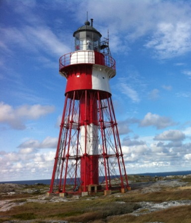
Måseskärs Fyr
Måseskär Light, Orust, August 2010
Flickr Creative Commons photo by Eric & Pia Sjostedt
Tjörn Municipality Lighthouses

Tjörn Area Lighthouses
Tjörn occupies the island of the same name, the sixth largest Swedish island. The island is a popular resort destination. It has a permanent population of about 16,000 and is accessible by a series of bridges from Stenungsund on the mainland.
Eggskär
1904. Active; focal plane 8 m (26 ft); two flashes every 6 s, white, red or green depending on direction. 8 m (26 ft) round stone tower with lantern and gallery, painted white. Gordon Pettersson's photo is at right, he also has a 2020 closeup, Trabas also has a photo, Håkan Larson has a distant view, and Google has a satellite view. Three of the photos also show an older stone beacon, painted white with one black horizontal band. Daybeacons of this kind are very common in Sweden. Located on a skerry about 1.2 km (3/4 mi) west of Klädesholmen. Accessible only by boat. Site open, tower closed. ARLHS SWE-121; SV-8120; Admiralty C0486; NGA 0664.
Norra Kyrkesund Övre
1930. Active; focal plane 10 m (33 ft); white light, 2 s on, 2 s off. 4 m (13 ft) square wood building. The light was formerly shown through a square window but is now mounted just above the window. Building painted white. Trabas has a photo, Hartmann has a page for the range lights, and Google has a street view and a satellite view. The range guides vessels southward into the harbor of Kyrkesund. The front light is a small tower in the harbor. Located on a bluff on the north side of Kyrkesund. Site status unknown. SV-8161.01; Admiralty C0474.1; NGA 0636.
Räbbehuvud
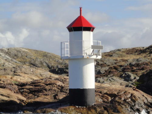
1933. Active; focal plane 14 m (46 ft); two flashes every 6 s, white, red or green depending on direction. 10 m (33 ft) round cylindrical concrete tower with lantern and gallery. Upper 2/3 of the lighthouse painted white, lower 1/3 black. Bengt Wallin has a photo, Trabas has a distant view, and Google has a satellite view. Located on the northern tip of an island about 2.5 km (1.5 mi) west of Ångeviken. Accessible only by boat. Site open, tower closed. SV-8140; Admiralty C0464; NGA 0616.

Stenungsund Municipality Lighthouses

Galterön
1915. Active; focal plane 5 m (17 ft); two flashes every 6 s, white, red or green depending on direction. 4 m (13 ft) octagonal lantern, painted white. SFA has a page for the lighthouse, Trabas has a closeup, and Google has a satellite view. Located on a promontory in the channel connecting the Halsefjord and the Askeröfjord, east of the island of Stora Askerön. Site status unknown (probably on private property), tower closed. ARLHS SWE-144; SV-7983; Admiralty C0506; NGA 0808.
Eggskärs Fyr
Eggskär Light, Tjörn, July 2007
photo copyright Gordon Pettersson; used by permission
Mitholmarna
1944. Active; focal plane 7 m (23 ft); four flashes every 12 s, white, red or green depending on direction. 5 m (17 ft) round cylindrical tower with lantern and gallery, painted white. Hartmann has a page for the light, Trabas has Hartmann's distant photo, and Google has a satellite view. Located on a small island in the lower Halsefjord off Aröd. Accessible only by boat. Site open, tower closed. SV-7960; Admiralty C0502; NGA 0752.

Orust Municipality Lighthouses

Orust occupies the island of the same name: the third largest island of Sweden (after Gotland and Öland). The island has a population of about 15,000. It is separated from the mainland by narrow channels; the channels to the north and south are crossed by bridges on highway 160.

Mollösund and Bråtö Lighthouses
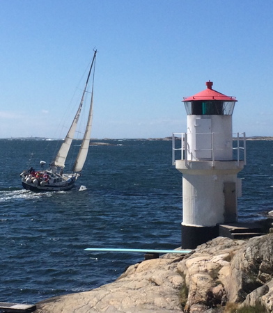
Mollösund
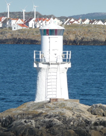
1930. Active; focal plane 7 m (23 ft); two flashes every 6 s, white, red or green depending on direction. 7 m (23 ft) round concrete tower with octagonal lantern and gallery. Lighthouse painted white with a black band at the base, lantern roof red. Bo Eriksson's photo is at right, Chris Lofqvist has a sunset photo, Trabas has Klaus Kern's closeup photo, Hartmann's page has a photo, a 2021 photo is available, and Google has a satellite view. Located on a promontory at the northern entrance to the harbor of Mollösund. Accessible by road. Site open, tower closed. SV-8177; Admiralty C0460; NGA 0596.
Bråtö (2)
2022 (station established 1930). Active; focal plane 7 m (23 ft); four flashes every 12 s, white, red or green depending on direction. 7 m (23 ft) light atop a fiberglass cabinet on the original round white concrete base. This light replaced a 7 m (23 ft) round concrete tower with octagonal lantern and gallery.; SFA has a small photo. Google has a satellite view. Located on the southwest side of the island of Bråtö, about 2 km (1.2 mi) south southeast of Hälleviksstrand. Accessible only by boat. Site open, tower closed. SV-8182; Admiralty C0458; NGA 0592.
Kråksundsgap Södra (Kråksundsgap South) (2)
1954 (station established 1941). Active; focal plane 13 m (43 ft); two flashes every 6 s, white, red or green depending on direction. 13 m (43 ft) round cylindrical concrete tower with lantern and gallery. Entire lighthouse painted white. Trabas has a photo, Marz van der Eng has a photo, Hartmannn's page has a photo, and Google has a satellite view. The Kråksundsgap is a narrow passage between the small islands of Högholmen and Bråtö. This light on the south side of the gap replaced a pair of range lights built at 1890 on the other side. Located at the northwestern point of the island of Bråtö, about 1.6 km (1 mi) south of Hälleviksstrand. Accessible only by boat. Site open, tower closed. ARLHS SWE-221; SV-8187; Admiralty C0452; NGA 0608.

Mollösund Light, Mollösund, June 2016
ex-Google Plus photo by Bo Eriksson

Måseskär and Kärringö Lighthouses
Måseskär (1)
1865 (Nils Gustaf von Heidenstam). Inactive since 1978 (by tradition, the light is turned on for 12 minutes at midnight each New Year's Eve). 27 m (89 ft) pyramidal cast iron skeletal tower with lantern, gallery, and central cylinder. Lighthouse painted in a red and white checkerboard pattern. A 3rd order Fresnel lens (1887) is mounted in the tower. There are several 1-story keeper's houses and other light station buildings. Eric Sjostedt's photo is at the top of this page, another photo is at right, SFA has a page for the lighthouse, Hartmann also has a page, Wikimedia has a photo of the station, Marinas.com has aerial photos, Trabas has Hartmann's view from the sea, Rainer Toivonen has a photo of the old and new lighthouses, Huelse has a historic postcard view, Joachim Reif has a street view from atop the lighthouse, and Google has a satellite view. This is one of the oldest of the cast iron skeletals built by the Swedish engineer Nils Gustaf von Heidenstam. A preservation group, Stiftelsen Måseskär, was founded in 1983 to work for preservation of the light station. The group was granted a lease of the lighthouse and a thorough restoration was carried out in 1988. Måseskär is a small island in the Skagerrak about 2 km (1.2 mi) southwest of Kärringö. Accessible only by boat, but there is water taxi service from Kärringö. Site open, tower closed. Site manager: Stiftelsen Måseskär . ARLHS SWE-047.
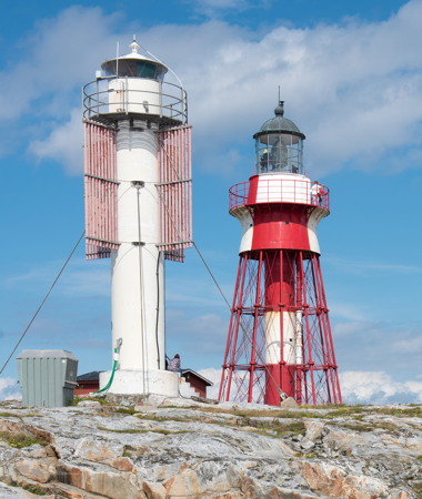
Måseskär (2)
1978 (station established 1865). Active; focal plane 27 m (89 ft); three long (1.5 s) flashes every 30 s, white, red or green depending on direction. 13 m (43 ft) round cylindrical fiberglass tower with lantern and gallery, painted white. Four vertically slatted daymark panels, mounted near the top of the tower, provide a square red daymark. A photo is at right, Håkon Samuelsson has a photo, Joachim Reif has a street view from atop the historic lighthouse, and a 2010 photo is available; there's also a photo of the station showing both lighthouses, Trabas has Hartmann's view from the sea, and Google has a satellite view. Located very close to the historic lighthouse. Accessible only by boat. ARLHS SWE-276; SV-8206; Admiralty C0456; NGA 0588.
Käringö Kummel
2021 (station established 1929). Active; focal plane 9 m (30 ft); white or green light, depending on direction, 1.5 s on, 1.5 s off. 7 m (23 ft) light atop a fiberglass cabinet on the original round white concrete base. This light replaced a round solid rubblestone tower with lantern and gallery. Ursula Lundgren has a 2020 photo, Hartmann has a page for the lighthouse, Trabas has a distant view, Huelse has a historic postcard view, and Google has a satellite view. A kummel is a small rubblestone cairn. Located on a promontory east of the harbor of Kärringö. This light should be accessible by hiking from Kärringö. Site open, tower closed. SV-8216; Admiralty C0446; NGA 0572.

New (left) and old Måseskär Lights, Kärringö, August 2015
Flickr Creative Commons photo by thriol
Oxskär
2021 (station established 1929). Active; focal plane 7 m (23 ft); three flashes every 9 s, white, red or green depending on direction. 6 m (20 ft) light atop a fiberglass cabinet on the original round white concrete base. This light replaced an octagonal lantern mounted on a round concrete base. Hartmann's page has a closeup photo, Trabas has a distant view (note the Måseskär lighthouses at the extreme left of the photo) and Google has a satellite view. Located on a small island halfway between Kärringö and Saltö. Accessible only by boat. Site open, tower closed. ARLHS SWE-309; SV-8211; Admiralty C0448; NGA 0584.

Gullholmen Area Lighthouses
Råö Övre
2021 (station established 1929). Active; focal plane 8 m (26 ft); white or green light, depending on direction, 2.5 s on, 2.5 s off. 4 m (13 ft) ight atop a fiberglass cabinet. This light replaced an octagonal lantern, painted white; lantern roof painted red. Hartmann has a page for the range lights, Christer Nilsen has a view from the sea and Google has a satellite view. Located on the northwestern coast of the island of Råö, about 2 km (1.2 mi) south of Gullholmen. Site status unknown. SV-8230.01; Admiralty C0427; NGA 0544.
Fredagsholmen (2)
1943 (station established 1883). Active; focal plane 5.5 m (18 ft); flash every 3 s, white, red or green depending on direction. 6 m (20 ft) round cylindrical concrete tower with lantern and gallery. Lighthouse painted white; lantern roof painted red. SFA has a page for the lighthouse including Leif Elsby's photo at right, Trabas has a nice view from the sea, and Google has a satellite view. Located on the south point of an island about 1.5 km (1 mi) east of Gullholmen. Accessible only by boat. Site status unknown. ARLHS SWE-141; SV-8247; Admiralty C0404; NGA 0448.
Hättan
1938. Active; focal plane 15 m (49 ft); two flashes every 6 s, white, red or green depending on direction. 9 m (30 ft) round tower, painted white with one black horizontal band. Trabas has a distant view, another distant view is available, and Google has a satellite view. Located on a skerry just off the northwestern point of the island of Stora Härmanö, about 1 km (0.6 mi) west of Gullholmen. This light should be approachable by hiking from Gullholmen. Site open, tower closed. ARLHS SWE-187; SV-8263; Admiralty C0402; NGA 0444.

Fredagsholmen Light, Gullholmen, September 2017
SFA Creative Commons photo by Leif Elsby

Havstensfjord South Side Lighthouses

The Havstensfjord provides a narrow, protected waterway running around the northern and eastern sides of the island of Orust.
Såten
1943. Active; focal plane 7 m (23 ft); two flashes every 6 s, white, red or green depending on direction. 4 m (13 ft) octagonal lantern, painted white, mounted on a round concrete base. Trabas has a good closeup and Google has an indistinct satellite view. Located on the east side of the Havstensfjord about 3 km (2 mi) north of Henån. Probably accessible only by boat. Site open, tower closed. SV-8079; Admiralty C0412.5; NGA 0500.
Kollholm
1944. Active; focal plane 16 m (52 ft); white, red or green light depending on direction, 2 s on , 2 s off. 7 m (23 ft) round cylindrical tower with lantern and gallery, painted white. Trabas has a photo, Hartmann has a page for the light, Apinya Dalek has a street view, and Google has a satellite view. Located on an island in the Havstensfjord opposite the Björningarna light and about 1.5 km (1 mi) west southwest of Bräcke. Accessible only by boat. Site open, tower closed. SV-8006; Admiralty C0417.5; NGA 0832.
* Svanesund
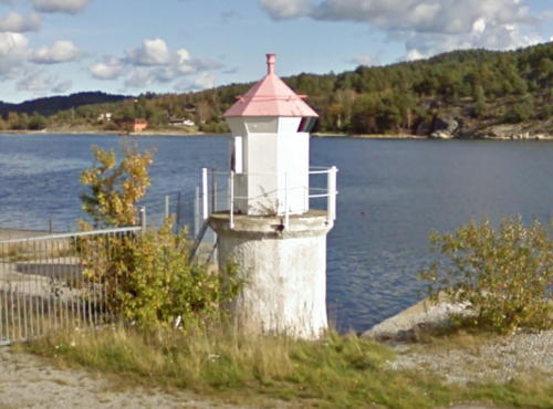
1915. Active; focal plane 4 m (13 ft); flash every 3 s, white, red or green depending on direction. 6 m (20 ft) round cylindrical concrete tower with lantern and gallery. The tower is unpainted; lantern painted white with a red roof. A photo is at right, Trabas has Klaus Kern's closeup photo, Hartmann has a page for the lighthouse, Lars Niklasson has a 2009 closeup, and Google has a street view and a satellite view. Svanesund, at the southeastern corner of Orust, is the terminal for the a ferry that crosses the Havstensfjord from Kolhättan on the mainland. Located about 100 m (110 yd) north of the ferry wharf in Svanesund. Site open, tower closed. ARLHS SWE-384; SV-7986; Admiralty C0510; NGA 0812.

Svanesund Light, Svanesund, October 2009
Google Maps street view

Lysekil Municipality Lighthouses

Grundsund Area Lighthouses
Islandsberg (1)
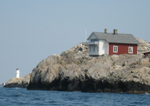
1883. Inactive since 1938. 6 m (20 ft) 1-1/2 story wood keeper's house; the light was displayed through an upper story window. The seaward end of the house is painted white, and the rest red. W.A. Hammer's photo of both lighthouses is at right, Calle Fjällstål has a closeup photo, Huelse has a historic postcard view, and Google has a satellite view. The house was sold as a private residence in 1948. Located on an islet just off the tip of the rocky Islandsberg peninsula about 2 km (1.2 mi) southwest of Grundsund and the same distance north of Gullholmen. Accessible only by boat. Site open, tower closed. ARLHS SWE-476.
Islandsberg (3)
1990s (station established 1883). Active; focal plane 13 m (43 ft); four flashes every 12 s, white, red or green depending on direction. 7 m (23 ft) round cylindrical fiberglass tower with lantern and gallery. Lighthouse painted white; lantern roof painted red. Trabas has a closeup photo, R. Onschroeder has a view from the sea, and Google has a satellite view. This lighthouse replaced a very similar concrete tower built in 1938. Located on an islet just off the tip of the rocky Islandsberg peninsula about 2 km (1.2 mi) southwest of Grundsund and the same distance north of Gullholmen. Accessible only by boat. Site open, tower closed. ARLHS SWE-203; SV-8252; Admiralty C0400; NGA 0440.
Grötö
1917. Active; focal plane about 16 m (52 ft); flash every 3 s, white, red or green depending on direction. 4 m (13 ft) round lantern, mounted on a round concrete or masonry base. Lantern painted white with a red roof. SFA has a page for the lighthouse, Trabas has Klaus Kern's photo, and Google has a satellite view. Located on the southeastern tip of the island of Grötö, about 800 m (1/2 mi) west of the northern entrance to the harbor of Grundsund. Accessible only by boat. Site open, tower closed. SV-8255; Admiralty C0394; NGA 0432.
Islandsbergs Fyr
Islandsberg Light, Grundsund, August 2006
ex-Panoramio photo copyright W.A. Hammer; used by permission

Lysekil Area Lighthouses
Släggabåden
1961. Active; focal plane 7 m (23 ft); white, red or green light depending on direction, 2 s on, 8 s off. 8 m (26 ft) round tower with octagonal lantern and gallery, mounted on a concrete base. Lighthouse painted white. SFA has a page for the lighthouse, Trabas has a closeup photo, and Google has a distant satellite view. Located a short distance offshore at the western entrance to Lysekil harbor. Accessible only by boat. Site open, tower closed. ARLHS SWE-471; SV-8283; Admiralty C0392; NGA 0404.
Flatholmen (2)
1972 (station established 1917). Active; focal plane 10 m (33 ft); flash every 4 s, white, red or green depending on direction. 4 m (13 ft) round lantern, painted white, mounted on a round concrete or masonry base. Trabas has a photo, Hartmann's page has a photo, and Google has a distant satellite view. This light is also barely visible on the point in the right background of the photo of Stångehuvuds Fyr below. Located on the northeastern coast of a rocky island just off the harbor of Lysekil. Accessible only by boat. Site open, tower closed. ARLHS SWE-137; SV-8275; Admiralty C0390; NGA 0400.
* Stångholmen (2)
1974 (station established 1940). Active; focal plane 6 m (20 ft); white, red or green light depending on direction, 2 s on, 2 s off. 4 m (13 ft) round lantern, mounted on a concrete or masonry base. Lantern painted white. Trabas has a good photo, Hartmann has a page for the light, and Google has a satellite view. Located on an island just off Lysekil harbor, about 500 m (0.3 mi) north of the Flatholmen light. Accessible only by boat. Site open, tower closed. ARLHS SWE-365; SV-8299; Admiralty C0388; NGA 0388.
* Stångehuvud
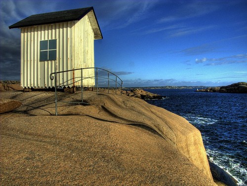
1890. Inactive since the 1990s. 4 m (13 ft) square wood building, painted white; the A-frame roof is black. Chris Lofqvist's photo is at right, SFA has a page for the lighthouse, Huelse has a historic postcard view, and Google has a distant satellite view. This little lighthouse is preserved as a landmark within the Stångehuvud Nature Reserve, which occupies a rocky peninsula projecting into the Skagerrak west of Lysekil. Located on a promontory at the west end of the peninsula. Accessible by a hiking trail. Site open, tower closed.
Gäven (2)
1941 (station established 1917). Active; focal plane 27 m (89 ft); three flashes every 9 s, white, red or green depending on direction. 9.5 m (31 ft) round cylindrical concrete tower with lantern and gallery. Lighthouse painted white with one black horizontal band. Hartmann has a page for the lighthouse, Trabas has a distant view, and Google has a satellite view. Located on a small island in the Skagerrak about 6 km (3.5 mi) west of Lysekil. Accessible only by boat. Site open, tower closed. ARLHS SWE-150; SV-8269; Admiralty C0384; NGA 0392.
Gulskåren
1917. Active; focal plane 9 m (30 ft); two flashes every 6 s, white, red or green depending on direction. 6 m (20 ft) round cylindrical concrete tower with lantern and gallery. Lighthouse painted white. Trabas has a more distant view, SFA has a page for the lighthouse, and Google has a satellite view. Located on Sodra Gulskår, a skerry about 2.5 km (1.5 mi) northwest of Lysekil. Accessible only by boat. Site open, tower closed. ARLHS SWE-431; SV-8272; Admiralty C0382; NGA 0396.

Stångehuvud Light, Lysekil, July 2007
Flickr Creative Commons photo by Chris Lofqvist

Skalhamn Area Lighthouses
Hängdyn
1949. Active; focal plane 5 m (16 ft); quick-flashing light, white, red or green depending on direction. 6 m (20 ft) round cylindrical concrete tower with lantern and gallery. Lantern painted white with a red roof; tower painted black. Trabas has a view from the sea, Hartmann has a page for the light, and Google has a satellite view. Located in the water about 1.5 km (1 mi) south of Skalhamn. Accessible only by boat. Site open, tower closed. ARLHS SWE-179; SV-8300; Admiralty C0381.5; NGA 0380.
Svensholmen (3)
2003 (station established 1890). Active; focal plane 14 m (46 ft); three flashes every 9 s, white, red or green depending on direction. 7 m (23 ft) round cylindrical concrete tower with lantern and gallery, painted white. Trabas has a view from the sea, Hartmann has a page for the lighthouse, and Google has a satellite view. The second (about 1920) lighthouse was sold and relocated to Malmön, where is known as the Snurransfyr (see Northern Bohuslän). Located at the northwestern tip of Lilla Kornö, about 2.5 km (1.5 mi) west of Skalhamn. Site open, tower closed. ARLHS SWE-387; SV-8314; Admiralty C0379; NGA 0364.
Lindholmen Västra
1974. Active; focal plane 27 m (89 ft); red light, 4 s on, 4 s off. 15 m (49 ft) round cylindrical tower, painted red; the tower also carries a rectangular red slatted daymark. Hartmann has a page for the Lindholmen lights, the lighthouse is on the left in Trabas's photo and Google has a satellite view. The several Lindholmen lights are used in combination with the Fiskebäcksvik light (see below) to guide vessels entering the Brofjord. Located on a rocky island about 2 km (1.2 mi) southwest of Skalhamn. Accessible only by boat. Site open, tower closed. ARLHS SWE-470; SV-8325; Admiralty C0376.43; NGA 0330.
Lindholmen Mellersta
1974. Active; focal plane 27 m (89 ft); white light, 4 s on, 4 s off. 13 m (43 ft) round cylindrical tower, painted red; the tower also carries a rectangular red slatted daymark. Hartmann has a page for the Lindholmen lights, the lighthouse is at the center of Trabas's photo and Google has a satellite view. The several Lindholmen lights are used in various combinations to guide vessels through a particularly complicated area of the coast. Located on a rocky island about 2 km (1.2 mi) southwest of Skalhamn. Accessible only by boat. Site open, tower closed. ARLHS SWE-264; SV-8324; Admiralty C0376.4; NGA 0324.
Bläckhall
1890. Active; focal plane 9 m (30 ft); two flashes every 6 s, white, red or green depending on direction. 7 m (23 ft) round lantern on a semicircular concrete base. Lantern painted white with a red roof. Google has an indistinct satellite view. Located on the tip of a rocky promontory on the west side of Skalhamn. Site status unknown. SV-8301; Admiralty C0380; NGA 0376.
Tinnholmen
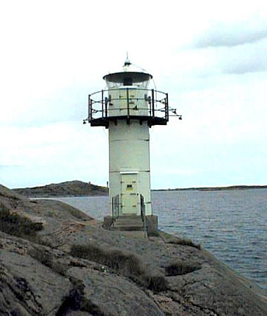
1974. Active; focal plane 13 m (43 ft); quick-flashing light, white, red or green depending on direction. 8 m (26 ft) round cylindrical cast iron tower with lantern and gallery, painted white. SFA's page for the lighthouse includes the photo at right, Trabas has a distant view, and Google has an indistinct satellite view. Located at the edge of the water at the north end of a small island on the east side of the Brofjord about 800 m (1/2 mi) north of Skalhamn. Accessible only by boat. Site open, tower closed. SV-8320; Admiralty C0378.6; NGA 0344.
Stretrudden Övre
1974. Active; focal plane 58 m (190 ft); white light, 2 s on, 2 s off. 16 m (52 ft) round cylindrical tower with gallery; vertically slatted panels on each side of the lantern provide a rectangular daymark. Lighthouse and daymark painted white with a black horizontal band. Trabas has a photo, Hartmann has a page for the range lights, and Google has a satellite view. The range guides vessels into a protected harbor of the Brofjord, site of a large petroleum depot, north of Skalhamn. The front light is in a small round lantern. Located adjacent to the petroleum depot, about 1.7 km (1.1 mi) northeast of the front light. Site open, tower closed. ARLHS SWE-473; SV-8321.01; Admiralty C0376.51; NGA 0336.

Tinnholmen Light, Skalhamn, October 2016
SFA Creative Commons photo by Leif Elsby
Kåvra
1974. Active; focal plane 10 m (33 ft); flash every 3 s, white, red or green depending on direction. 11 m (36 ft) round cylindrical concrete tower with lantern and upper and lower galleries, painted white. Hartmann has a page for the lighthouse, Trabas has Hartmann's photo, and Google has a satellite view. Located in the water about 3 km (2 mi) southeast of Malmön and the same distance northwest of Skalhamn. Accessible only by boat. Site open, tower closed. ARLHS SWE-467; SV-8319; Admiralty C0378.4; NGA 0372.
* Fiskebäcksvik (Övre)
Date unknown. Active; focal plane 63 m (207 ft); white light, 4 s on, 4 s off. 8 m (26 ft) square observation tower with gallery. The building is unpainted white concrete. The light is the rear light of a range that guides vessels northbound into the Brofjord. Trabas has a good photo, Hartmann has a page for the light, Calle Fjällstål has a closeup photo, and Google has a satellite view. The observation building appears to be unused. Located on a rocky bluff about 1 km (0.6 mi) north of Skalhamn. Site open, building closed. SV-8326; Admiralty C0376.41; NGA 0328.

Brandskär Area Lighthouses
#Tän (1)
1974. Destroyed in 2015. This was an 8 m (26 ft) round cylindrical tower with lantern and gallery. Lighthouse painted white; the gallery rail and the concrete base painted gray. Trabas has a distant view taken from Hartmann's page and Google has a satellite view. The lighthouse was overthrown by a severe windstorm in January 2015. It was replaced by a light on a triangular skeletal mast (focal plane 12 m (39 ft); quick-flashing white light). Located on an island about 2 km (1.2 mi) south of the southern tip of Malmön. Accessible only by boat. Site open, tower closed. Active light: SV-8318; Admiralty C0378.2; NGA 0340.
Brandskärsflak (Brandskärs Flak)
1974. Active; focal plane 25 m (82 ft); white, red or green light, depending on direction, occulting twice every 8 s. 26 m (85 ft) round cylindrical tower with upper and lower galleries, lantern, and a helipad atop the lantern. Lighthouse painted white with one green horizontal band. Trabas has a distant view, Hartmann has a page for this light and the next one, this light is on the left in Martin Hammar's distant street view from shore, and Google has a satellite view. This light and the Dynabrott Light are located within a few hundred meters of each other, marking ends of the same shoal. Located on a shoal in the Skagerrak about 5 km (3 mi) southeast of Sotenäs and 6 km (3.5 mi) west of Lysekil. Accessible only by boat. Site open, tower closed. ARLHS SWE-105; SV-8317; Admiralty C0376; NGA 0316.
Dynabrott
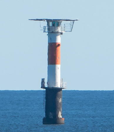
1974. Active; focal plane 25 m (82 ft); white, red or green light, depending on direction, occulting once every 8 s. 26 m (85 ft) round cylindrical tower with upper and lower galleries, lantern, and a helipad atop the lantern. Lighthouse painted white with one red horizontal band. A view by W. Carter is at right, Trabas has a distant view, Hartmann has a page for this light and the previous one, this light is on the right in Martin Hammar's distant street view from shore, and Google has a satellite view. Lighthouse painted white with one red horizontal band. Located on a shoal in the Skagerrak about 5 km (3 mi) southeast of Sotenäs and 6 km (3.5 mi) west of Lysekil. Accessible only by boat. Site open, tower closed. ARLHS SWE-119; SV-8316; Admiralty C0376.2; NGA 0320.

Information available on lost lighthouses:

  • Högholmen (1890-1911), Orust. The lighthouse was replaced by the Kråksundsgap Södra lighthouse (see above).

Notable faux lighthouses:


Dynabrott Light, Skagerrak, June 2018
Wikimedia Creative Commons photo by W. Carter

Adjoining pages: North: Tanum Area | South: Göteborg Area

Return to the Lighthouse Directory index | Ratings key

Posted March 18, 2007. Checked and revised March 6, 2024. Lighthouses: 39. Site copyright 2024 Russ Rowlett and the University of North Carolina at Chapel Hill.