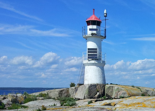
Lighthouses of Sweden: Blekinge (Karlskrona Area)

The Kingdom of Sweden (Sverige in Swedish) is the largest country of northern Europe, occupying the entire west coast of the Baltic Sea. Along with its lengthy coast Sweden has a distinguished lighthouse history and a good record of preserving its historic lights. The Swedish Lighthouse Society (Svenska Fyrsällskapet) works actively for the preservation of the lighthouses.

Sweden is divided into 21 counties (län) and the counties are subdivided into townships and municipalities (kommuner). This page covers lighthouses of the county of Blekinge (Blekinge Län) in southeastern Sweden. This is one of Sweden's smallest counties, but it includes the important port of Karlskrona, the home port of the Swedish Navy and Coast Guard. Karlshamn and Ronneby are smaller ports in the county. The coastline of the county faces mostly south on Hanö Bay, a sheltered embayment of the Baltic Sea.

The Swedish word for a lighthouse is fyr. The front light of a range is the nedrefyr (lower light) and the rear light is the övrefyr (upper light). Ö is an island, holme is an islet, skär is a skerry (a tiny island or rocky reef), grund is a shoal or shallow, sund is a strait (often between an island and the mainland), vik is a bay, hav is a sea, udde is a headland, flod is a river, and hamn is a port or harbor.

Aids to navigation in Sweden are maintained by the Swedish Maritime Administration (Sjöfartsverket).

ARLHS numbers are from the ARLHS World List of Lights. SV numbers are from the Sjöfarsverket light list (Svenska Fyrlista) as reported by the Swedish Lighthouse Society. Admiralty numbers are from volume C of the Admiralty List of Lights & Fog Signals. U.S. NGA List numbers are from Publication 116.

General Sources
Swedish Lighthouse Society (Svenska Fyrsällskapet, SFA)
The Society is active in promoting the preservation of Swedish lighthouses.
Svenskt Fyrväsende
From the SFA web site, data and photos for many of the lighthouses.
Lighthouses in Sweden
Aerial photos posted by Marinas.com.
Online List of Lights - Sweden
Photos by various photographers posted by Alexander Trabas.
Lighthouse Pages from Anke and Jens - Sweden
Photos and brief accounts (in English) by two German lighthouse fans.
Leuchttürme und Leuchtfeuer in Schweden - Svenska Fyrar
A large collection of photos and data posted by Erich Hartmann; text in German.
Fyr Vi Har Passeret (Lighthouses We've Passed)
Photos of Baltic lighthouses taken by two Danish sailors, Jette and Ole.
Lighthouses in Sweden
Photos by various photographers available from Wikimedia.
World of Lighthouses - Sweden
Photos by various photographers available from Lightphotos.net.
Schwedische Leuchttürme auf historischen Postkarten
Historic postcard views posted by Klaus Huelse.
Navionics Charts
Navigational chart for Blekinge.

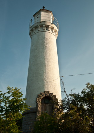
Karlskronas Fyr
Karlskrona Light, Karlskrona, June 2012
Flickr Creative Commons photo by Johannes Winger-Lang
Karlskrona Lighthouses
Founded as a naval base in 1680, Karlskrona is built on a number of islands, of which Trossö is the largest. The city is known for its Baroque architecture and numerous historical sites.

Utlängan
1931 (station established 1882). Active; focal plane 13 m (43 ft); white, red or green light, depending on direction, occulting twice every 12 s. 13 m (43 ft) round cylindrical concrete tower with lantern and gallery. The upper half of the lighthouse is painted black, lower half white. The 1-story keeper's house, painted white with a green roof, is a private summer residence. SFA has a page for the lighthouse, Lena Ehrlow has a 2020 photo, a 2008 closeup is available, and Google has a satellite view. The light guides coastal traffic through the passage between Utklippan and the island of Utlängan. The original lighthouse was an 8 m (26 ft) octagonal tower. Located on the southern tip of the island of Utlängan. Accessible only by boat. Site and tower closed. Site manager: private. . ARLHS SWE-406; SV-6027; Admiralty C7440; NGA 7708.
Flötjen
1957. Inactive since 2021. 10 m (33 ft) round cylindrical tower with lantern and gallery, painted white. Trabas has Klaus Kern's photo, SFA has a page for the lighthouse, and Google has a satellite view. The light was deactivated in August 2021. Located on a reef about 2.5 km (1.5 mi) northwest of Utlängen Fyr. Accessible only by boat. Site open, tower closed. ARLHS SWE-139; ex-SV-6070; ex-Admiralty C7438.8; NGA 7648.
Utklippan (3)
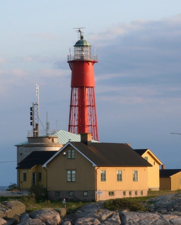
1870 (Nils Gustaf von Heidenstam) (station established 1789). Active; two flashes every 6 s, white, red or green depending on direction. 30 m (98 ft) round cast iron skeletal tower with lantern, gallery, and central cylinder, rising from one corner of a stone fortress. Lighthouse painted red; lantern dome is gray metallic; fortress painted white. 4th order Fresnel lens in use. Piet and Anneke Admirall's photo is at right, Wikipedia has a photo by Jesper Kimblad, Bengt Körling has a good 2008 photo, Trabas has a photo by Pauline and Wim de Kleine, another good photo is available, Marinas.com has aerial photos, and Google has a satellite view. The first light here was a basket light first shown in 1789. The fortress was built in 1840 and provided with a light, which was replaced by the present lighthouse in 1870. The traditional main light (white flash every 15 s) was deactivated in August 2008, leaving only the former passing light in service. The fortress includes a hostel offering overnight accommodations. Located on a small island in the Baltic about 16 km (10 mi) southeast of Karlskrona. The island is now a nature reserve. Accessible only by boat. Site open, tower closed. Site manager: Utklippan Harbour and Hostel . ARLHS SWE-073; SV-6015; Admiralty C7442; NGA 7696.
Godnatt (3)
1977 (station established 1879). Active; focal plane 20 m (66 ft); flash every 3 s, white, red or green depending on direction. 20 m (66 ft) octagonal stone fort with a pyramidal metal roof; the light is perched at the vertex of the pyramid. The building is unpainted stone; the roof is dark blue. Hartmann has another page for the lighthouse, Günter Kriems has a closeup photo, Trabas has a photo, Wojciech Czapiewski has a 2016 photo, a 2008 photo is available, Huelse has a historic postcard view, and Google has a satellite view. The white sector of this light is the leading light for entering Karlskrona harbor. The fort was completed in 1860 but technology had already made it obsolete, so it was never in use. The original light was removed in 1960 and replaced by a light shown through a window of the fortress. Located in the roadstead about 1.2 km (3/4 mi) southeast of Karlskrona. Accessible only by boat. Site open, tower closed. SV-6108; Admiralty C7449; NGA 7572.
Utklippan Fyr
Utklippan Light, Karlskrona, May 2008
Flickr Creative Commons photo by Piet and Anneke Admiraal
* Karlskrona (Övre)
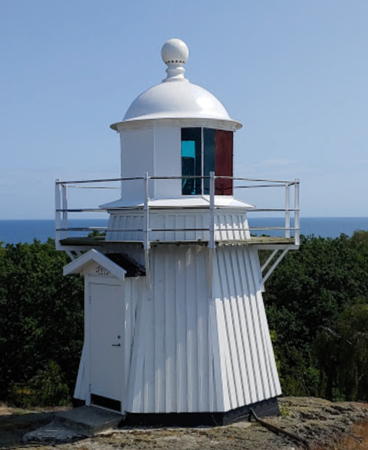
1918. Active; focal plane 37.5 m (123 ft); red light, 1.5 s on, 1.5 s off. 15 m (49 ft) round masonry tower with lantern and gallery, mounted on a round stone base. Lighthouse painted white; the conical lantern roof is black, and the stone base is unpainted. Johannes Winger-Lang's photo is at the top of this page, SFA has a page for the two Karlskrona range lighthouses, Trabas has a photo by Karl-Heinz Wellm, Gustav Björn has a photo, Marinas.com has aerial photos, and Google has a satellite view. Although it is accessible this lighthouse does not seem to be as well known as the Stumholmen lighthouses. For more than 90 years it was the rear light of the Stumholmen range, but the range was dropped from the charts in 2011. Located on a hilltop on the mainland, above the Saltsjöbadsvägen, 1.3 km (0.8 mi) north of the front lighthouse. Site open, tower closed. ARLHS SWE-213; SV-6099.01; Admiralty C7470; NGA 7560.
* Laboratorieholm
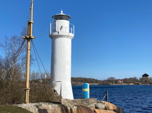
1892. Active; focal plane 11 m (36 ft); white, red or green light depending on direction, 2 s on, 2 s off. 11 m (36 ft) round cylindrical concrete tower with a lantern and gallery. Entire lighthouse painted white. A 2023 photo is at right, SFA has a page for the lighthouse, Sara Nilsson has a photo, Trabas has a closeup photo, a third photo is available, Marinas.com has aerial photos, and Google has a satellite view. Located at the northeastern tip of the island of Stumholmen, on the grounds of the Swedish Navy Museum (Marinmuseum). Site open, tower closed. ARLHS SWE-228; SV-6150; Admiralty C7462; NGA 7588.

Laboratorieholm Light, Karlskrona, APRIL 2023
Google Maps photo by Matte J
`  
* Stumholmen (Karlskrona Nedre)
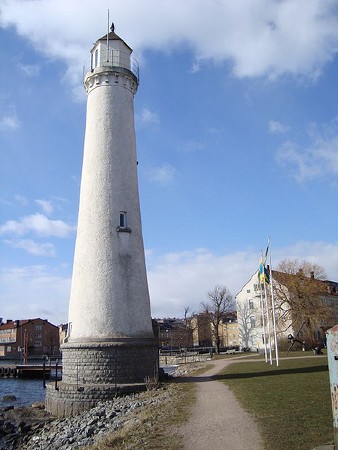
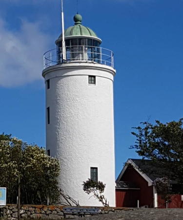
1918. Active; focal plane 22 m (72 ft); red light, 3 s on, 3 s off. 24 m (79 ft) round tapered masonry tower with lantern and gallery, mounted on a round stone base. Lighthouse painted white; the conical lantern roof is black, and the stone base is unpainted. Samuel Mann's photo is at right, SFA has a page for the two Karlskrona range lighthouses, Hartmann also has a page, Trabas has Klaus Kern's photo, Daoyong Liu has another fine photo, Wikimedia has a 2010 photo, Marinas.com has aerial photos, Huelse has a historic postcard view, Rien Koeling has a street view, and Google has a satellite view. The range guided vessels on their approach to the harbor of Karlskrona; it was discontinued in 2011. Located at the end of the Bastionsgaten on the island of Stumholmen, just off the east side of Trossö, near the National Naval Museum. Site open, tower closed. . ARLHS SWE-380; SV-6099; Admiralty C7460; NGA 7556.
Asla
1952. Inactive since 2021. 7 m (23 ft) wood shed mounted on a stone pier. Building painted white. Trabas has a distant photo and Google has an indistinct satellite view. Located on a skerry off the southwest coast of Hasslö, about 6 km (3.5 mi) southeast of Kuggeboda. Site open, tower closed. ex-SV-6213; ex-Admiralty C7453.4; NGA 7536.

Ronneby Lighthouses
Rönneskär
1954. Active; focal plane 9 m (30 ft); very quick (strobe-like) flashing light, white, red or green depending on direction. 8 m (26 ft) round cylindrical concrete tower with gallery; the light is displayed through a window at the top of the tower. Lighthouse painted white. Trabas has a photo, Hartmann has a page for the lighthouse, and Google has a satellite view. Located on a skerry about 800 m (1/2 mi) southeast of the waterfront of Kuggeboda. Accessible only by boat. Site status unknown. ARLHS SWE-328; SV-6227; Admiralty C7453.2; NGA 7520.
Saxemara Övre
Date unknown (station established 1904). Active; focal plane 10 m (33 ft); quick-flashing white light. 11 m (36 ft) square wood tower; the light is shown through a window. The side facing the range is painted white with two horizontal red bands; the other sides are painted all red. Trabas has a good photo, SFA has a page for the range lights, and Google has a satellite view. Located on an islet on the east side of Saxemara harbor. Site open, tower closed. SV-6249.01; Admiralty C7492.1; NGA 7476.
Stumholmen Fyr
Stumholmen Light, Karlskrona, March 2009
Flickr Creative Commons photo by Samuel Mann
Saxemara Nedre
Date unknown (station established 1904). Active; focal plane 4 m (13 ft); white light, 2 s on, 2 s off. 1-story wood shed; the light is shown through a window. The side facing the range is painted white; the other sides are painted red. Trabas has a photo, SFA has a page for the range lights, and Google has an indistinct satellite view. Located on Busseskär, a small island off the entrance to the harbor of Saxemara, about 4 km (2.5 mi) southwest of the Ronneby Hamn waterfront. Accessible only by boat. Site open, tower closed. SV-6249; Admiralty C7492; NGA 7472.
Gåsfeten
1904 (rebuilt 1968). Active; focal plane 12 m (39 ft); two long flashes every 15 s, white, red or green depending on direction. 10 m (33 ft) 2-stage tower: a round cylindrical cast iron tower with octagonal lantern and gallery is mounted on a round concrete tower. Jacek Lesniowski's photo is at right, Trabas has a distant view, and Google has a satellite view. In April 1906 this became the first lighthouse in the world to be fueled by acetylene; the Swedish physicist and engineer Gustaf Dalén received a Nobel Prize in 1912 for this innovation. Comparing current photos with historic photos, it's clear that the lower stage of the light is original but the upper stage was added much later, apparently in 1968. Located on Gåsfeten, an islet about 6 km (3.5 mi) southwest of the Ronneby Hamn waterfront. Accessible only by boat. Site open, tower closed. . ARLHS SWE-146; SV-6242; Admiralty C7490; NGA 7468.
Saltärna
1933. Active; focal plane 7 m (23 ft); three flashes every 9 s, white, red or green depending on direction. 4 m (13 ft) octagonal lantern, painted white, mounted on a round concrete pier. Trabas has a photo, SFA has a page for the lighthouse, and Google has a satellite view. This light marks the beginning of the approach to Ronneby. Located on the eastern tip of the island of Saltärna. Accessible only by boat. Site open, tower closed. SV-6278; Admiralty C7510; NGA 7464.
Gåsfetens Fyr
Gåsfeten Light, Ronneby, June 2012
ex-Panoramio photo copyright Jacek Lesniowski; used by permission
Vitaskär (2)
1941 (station established 1898). Active; focal plane 7 m (23 ft); quick-flashing light, white, red or green depending on direction. 4 m (13 ft) octagonal lantern, painted white, mounted on a concrete pad. Trabas has a photo and Bing has an indistinct satellite view. Located on a skerry about 2.5 km (1.5 mi) southeast of Garnanäs. Accessible only by boat. Site open, tower closed. SV-6283; Admiralty C7512; NGA 7420.

Karlshamn Lighthouses
Tärnö (2)
1910 (station established 1887). Active; focal plane 31 m (102 ft); white, red or green light depending on direction, 8 s on, 2 s off. 6 m (20 ft) octagonal wood tower with lantern and gallery, painted white. Johnny Bengtsson has the 2019 closeup sen at right, Martin Ericsson has a 2021 closeup, Wojciech Papieski has a street view, and Google has a satellite view. Tärnö is a small island about 3 km (2 mi) south of Matvik and 7 km (4 mi) southeast of Karlshamn. Accessible only by boat. Located on heights near the southern point of the island. The area surrounding the light is a nature reserve. Site open, tower closed. ARLHS SWE-389; SV-6288; Admiralty C7514; NGA 7412.
* Ortholmen (2)
1976 (station established 1896). Active; focal plane 6 m (20 ft); flash every 3 s, white, red or green depending on direction. 4 m (13 ft) round white lantern on a concrete base. Trabas has a photo, Madelene Jeffery has a closeup, Hartmann has a page for the light, and Google has a satellite view. A marine supply store and the former Karlshamn pilot station are adjacent to the light. Located on the tip of a promontory on the east side of the entrance to the harbor of Karlshamn. Site open, tower closed. Site manager: Sydkustens Sjötrafikområde. SV-6306; Admiralty C7519; NGA 7424.
* Ortholmen (1)
1896. Inactive since 1976. 4 m (13 ft) round white lantern. The original Ortholmen lantern has been relocated in front of the Blekinge Maritime Museum. Google has a street view and a satellite view. Located on the Hamngatan on the Karlshamn waterfront. Site open, tower closed. Site manager: Blekinge Sjöfartsmuseet.
 

Tärnö Light, Karlshamn, June 2012
Google Maps photo by Johnny Bengtsson

Sölvesborg and Hanö Lighthouses
* Listershuvud (2)
1934 (station established 1895). Active; focal plane 12 m (39 ft); flash every 4 s, white, red or green depending on direction. 4 m (13 ft) octagonal lantern, painted white, mounted on a concrete pad. Trabas has a photo, SFA has a page for the lighthouse, and Bing has a satellite view. The area surrounding the light is a nature reserve. Located on the easternmost tip of the Listerlandet peninsula near Hörvik and opposite Hanö. Accessible by a short hike from Hörvik. Site open, tower closed. SV-6399; Admiralty C7534; NGA 7352.
* Hanö (2)
1906 (station established 1869). Active; focal plane 70 m (230 ft); three white flashes every 13.5 s. 16 m (52 ft) round cylindrical brick tower with lantern and gallery, attached to a 1-1/2 story brick keeper's house. Tower painted white; lantern dome is greenish metallic; house is unpainted red brick. The original rotating 3rd order Fresnel lens remains in use and the diesel angines that formerly provided power for the station have been preserved. A photo by Jane Falk is at right, SFA has a good page for the lighthouse, Trabas has a photo by Karl-Heinz Wellm, Martin Ericsson has a 2021 photo, Marinas.com has aerial photos, Huelse has a historic postcard view, Ingo Voigt has a street view, and Google has a satellite view. The original lighthouse was described as a white tower on a keeper's house. Hanö is an inhabited island about 4 km (2.5 mi) off the southeastern tip of the Listerlandet peninsula. The island is a nature reserve. There is regular ferry service to the island from Nogersund. The lighthouse is located at the highest point of the island, a walk of about 1.2 km (3/4 mi) from the ferry terminal. Site open, tower closed. . ARLHS SWE-027; SV-6356; Admiralty C7538; NGA 7316.
* Hällevik
1922. Active; focal plane 8 m (26 ft); white, red or green light depending on direction, 4 s on, 4 s off. 7 m (23 ft) round concrete tower with lantern and gallery. The tower is unpainted white concrete. 1-story building adjoining the tower is presumably a keeper's cottage. SFA has a page for the lighthouse (the photo on this page shows the Hällevik South Breakwater Light, Admiralty C7550), Anders Bergdén has a 2008 photo, Trabas has a closeup photo by Karl-Heinz Wellm, Hartmann's page for the lighthouse has a good closeup photo, and Google has a satellite view. It appears that the tower is original but the lantern was replaced in 1957 when SFA says the lighthouse "received its current design." Hällevik is a village about 8 km (5 mi) east of Sölvesborg. Located on the east side of the town. Site open, tower closed. . ARLHS SWE-171; SV-6410; Admiralty C7548; NGA 7296.
* Sillnäsudde
1966 (unlit daybeacon established 1851). Active; focal plane 12 m (39 ft); two flashes every 6 s, white, red or green depending on direction. 12 m (39 ft) round cylindrical steel tower with gallery; the light is displayed through a curved window at the top of the tower. Upper half of the lighthouse painted white, lower half red. Bernd Mustermann has a 2022 photo, SFA has a page for the lighthouse, Trabas has a closeup photo, Hartmann's page for the lighthouse has a closeup photo, Per-Erik Ferb has a 2020 photo, and Google has a satellite view. Located on an islet at the tip of a promontory on the southwestern side of the Listerlandet peninsula, about 7 km (4 mi) southeast of Sölvesborg; the island is connected to the mainland by a causeway. Site open, tower closed. . ARLHS SWE-339; SV-6417; Admiralty C7551.6; NGA 7292.

Hanö Light, Sölvesborg, May 2019
Instagram photo by Jane Falk

Information available on lost lighthouses:

Notable faux lighthouses:

Adjoining pages: North: Kalmar | South: Scania

Return to the Lighthouse Directory index | Ratings key

Posted June 4, 2007. Checked and revised January 29, 2024. Lighthouses: 21. Site copyright 2024 Russ Rowlett and the University of North Carolina at Chapel Hill.