Lighthouses of Sweden: Västernorrland

The nation of Sweden (Sverige in Swedish) is the largest country of northern Europe, occupying the entire west coast of the Baltic Sea. Along with its lengthy coast Sweden has a distinguished lighthouse history and a good record of preserving its historic lights. The Swedish Lighthouse Society (Svenska Fyrsällskapet) works actively for the preservation of the lighthouses.

Sweden is divided into 21 counties (län) and the counties are subdivided into townships and municipalities (kommuner). This page covers lighthouses of the county of Västernorrland, a county located in the north of the country. The coastline of the county faces east on the Gulf of Bothnia, with Finland on the other side of the gulf, roughly 175-250 km (110-150 mi) away. This southern portion of the gulf is known in Sweden as the Bothnian Sea (Bottenhavet).

The coast in the Örnsköldsvik, Kramfors, and Härnösand municipalities is known as the High Coast (Höga Kusten). Since the last ice age this coast has risen about 300 m (about 1000 ft), creating tall cliffs and other unusual geological features. The area has been recognized as a Unesco World Heritage Area.

The Swedish word for a lighthouse is fyr. The front light of a range is the nedrefyr (lower light) and the rear light is the övrefyr (upper light). Ö is an island, holme is an islet, skär is a skerry (a tiny island or rocky reef), grund is a shoal or shallow, sund is a strait (often between an island and the mainland), vik is a bay, hav is a sea, udde is a headland, flod is a river, and hamn is a port or harbor.

Aids to navigation in Sweden are maintained by the Swedish Maritime Administration (Sjöfartsverket).

ARLHS numbers are from the ARLHS World List of Lights. SV numbers are from the Sjöfarsverket light list (Fyrlista) as reported by the Swedish Lighthouse Society. Admiralty numbers are from volume C of the Admiralty List of Lights & Fog Signals. U.S. NGA List numbers are from Publication 116.

General Sources
Swedish Lighthouse Society (Svenska Fyrsällskapet, SFA)
The Society is active in promoting the preservation of Swedish lighthouses.
Svenskt Fyrväsende
From the SFA web site, data and photos for many of the lighthouses.
Online Lists of Lights - Sweden
Photos by various photographers posted by Alexander Trabas.
Leuchttürme und Leuchtfeuer in Schweden - Svenska Fyrar
A large collection of photos and data posted by Erich Hartmann; text in German.
World of Lighthouses - Sweden
Photos by various photographers available from Lightphotos.net.
Lighthouses in Sweden
Photos by various photographers available from Wikimedia.
Lighthouses in Sweden
Photos posted by Marinas.com.
Schwedische Leuchttürme auf historischen Postkarten
Historic postcard views posted by Klaus Huelse.
Navionics Charts
Navigation chart for Sweden.

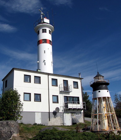
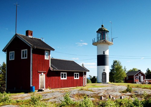
Skagsudde Fyr
Skagsudde Light, Örnsköldsvik, September 2009
(model of former lighthouse at lower right)
Wikimedia public domain photo by Petey21
Örnsköldsvik Lighthouses
Husum
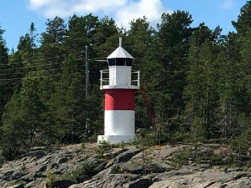
1890. Active; focal plane 13 m (43 ft); white, red or green light depending on direction, 2 s on, 2 s off. 7 m (23 ft) round cylindrical concrete tower with lantern and gallery. Lighthouse painted white with a red horizontal band below the gallery. Eskil Nygren's photo is at right, Trabas has a photo, and Bing has an indistinct satellite view. Located on Aggö, which is not an island but a peninsula on the west side of the entrance to the harbor of Husum. Accessible only by boat. Site open, tower closed. ARLHS SWE-201; SV-1099; Admiralty C5946; NGA 10980.
Skags Flasor
1958. Active; focal plane 6 m (20 ft); three flashes every 9 s, white, red or green depending on direction. 5 m (17 ft) round cylindrical concrete tower with lantern and gallery. Lighthouse painted white with a red horizontal band below the gallery. Trabas has a distant photo and Google has a satellite view. Located on a small island about 5 km (3 mi) east northeast of the Skagsudde lighthouse (next entry). Accessible only by boat. Site open, tower closed. SV-1122; Admiralty C5951; NGA 10936.
* Skag (Skags Udde, Skagsudde) (2)
1957 (station established 1871). Active; focal plane 39 m (128 ft); four white flashes every 12 s. 26 m (85 ft) round cylindrical concrete tower with gallery, its top crowded with communications gear, attached to a 2-story crew building. Lighthouse painted white with one narrow red horizontal band. A photo is at the top of this page, Hartmann has a page for the lighthouse, Alex Haas has a 2018 photo, Amarie Thiemsen has a 2021 photo, Marinas.com has aerial photos, Lage Sjöblom has a street view, and Google has a fuzzy satellite view. The original lighthouse, a classic design by the engineer Nils Gustaf von Heidenstam, has been relocated near Piteå in Norrbottens Län (see the Northern Bothnia page). Huelse has a historic postcard view of the original light station, and a scale model stands in front of the newer lighthouse. The station appears appears to be a staffed coast guard or maritime control station. Located at the end of a promontory of the mainland about 25 km (15 mi) east southeast of Örnsköldsvik. Accessible by road. Site open, tower closed. . ARLHS SWE-343; SV-1128; Admiralty C5952; NGA 10928.

Husum Light, Örnsköldsvik, August 2020
SFA Creative Commons photo by Eskil Nygren
Råskärsön
1935. Active; focal plane 24 m (79 ft); white, red or green light depending on direction, 6 s on, 2 s off. Approx. 6 m (20 ft) tower with lantern and gallery, painted white. Trabas has a very distant view and Google has a satellite view. Located at the east end of the island of Råskärsön, marking the entrance to Örnsköldsvik. Site status unknown. SV-1137; Admiralty C5960; NGA 10960.
Skommerskaten
1916. Active; focal plane 7 m (23 ft); flash every 3 s, white, red or green depending on direction. Lighthouse painted white with one narrow red horizontal band. Anneli Westerberg's 2021 photo is at right, Andreas Sager also has a photo, Trabas has a good photo, and Google has a distant satellite view. Located on a promontory about 7 km (4.5 mi) west northwest of Skagsudde. Site open, tower closed. SV-1142; Admiralty C5962; NGA 10964.
Trysundaön (Trysunda)
1967. Active; focal plane 10 m (33 ft); one long flash every 8 s, white, red or green depending on direction. 7.5 m (25 ft) round cylindrical concrete tower with lantern and gallery. Tower painted green, lantern white. SFA has a page for the lighthouse and Bing has a fuzzy satellite view. Trysunda is a small resort island with a well protected harbor. Located at the southwestern end of a chain of small islands about 10 km (6 mi) south of Örnsköldsvik. Accessible only by boat. Site open, tower closed. SV-1171; Admiralty C5973; NGA 10920.
Rone Flase (2)
1967 (station established 1909). Active; focal plane 13 m (43 ft); flash every 3 s, white, red or green depending on direction. 12.5 m (41 ft) round cylindrical concrete tower with lantern and gallery. Lighthouse painted white with a red horizontal band below the gallery. Google has a satellite view. Located on a small island in the channel between the islands of Norra Ulvö and Ronö, about 5 km (3 mi) north of Ulvöhamn. Accessible only by boat. Site open, tower closed. ARLHS SWE-326; SV-1172; Admiralty C5974; NGA 10916.

Skommerskaten Light, Örnsköldsvik, July 2021
Google Maps photo by Anneli Westerberg

Kramfors Lighthouses
Ytternäsan (2)
1953 (station established 1909). Active; focal plane 14 m (46 ft); white, red or green light depending on direction, 2 s on, 2 s off. 8 m (26 ft) round cylindrical concrete tower with lantern and gallery. Lighthouse painted white with a black horizontal band below the gallery. Trabas has a photo, a closeup is available, SFA has a page with a small photo, and Google has a satellite view. Located on a promontory of the mainland about 4 km (2.5 mi) east of Norrfällsviken. Site status unknown. ARLHS SWE-079; SV-1307; Admiralty C5978; NGA 10892.
Gnäggen
1953. Active; focal plane 10 m (33 ft); one very quick (strobe-like) flash every 6 s. 4 m (13 ft) round lantern on a concrete pedestal. Lantern painted white. Trabas has a distant view and Google has a satellite view. Located on a rocky islet about 4 km (2.5 mi) east of Ytternäsan. Accessible only by boat. Site open, tower closed. SV-1311; Admiralty C5979; NGA 10896.
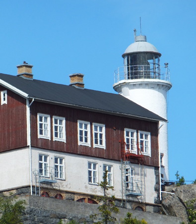
*** Högbonden
1909. Active; focal plane 75 m (246 ft); four white flashes every 12 s. 14 m (46 ft) round cylindrical tower with lantern and gallery, attached to a 2-story wood keeper's house. Lighthouse painted white; the upper story of the house is painted red and the lower story white. Magnus Häggström's photo is at right, SFA has a page for the lighthouse, Wikimedia has a fine photo by Henrik Sendelbach, Trabas has a photo by Pauline and Wim de Kleine, Jonas Lundström has a 2021 photo, Gustav Nilson has a street view, Marinas.com has aerial photos, Huelse has a historic postcard view in which the entire house is painted red, and Google has a satellite view. This is Sweden's second highest light. The 2nd order Fresnel lens (1845), formerly one of the most powerful lights of the Gulf of Bothnia, was transferred here from Ölands Södra Udde (see the Öland page). It was retired in 2010 but remains mounted in the tower. The house is a hostel and café offering overnight accommodations from May 1 through mid October. Located on an island just off the coast, about 30 km (19 mi) northeast of Härnösand. Site open, keeper's house open to guests and probably other visitors, tower status unknown. Owner (except light tower): Västernorrland County Administrative Board. Site manager: Högbonden Fyr und Vandrarhem . ARLHS SWE-194; SV-1317; Admiralty C5980; NGA 10890.

Härnösand Lighthouses
Åbordsö (2)
1964 (station established 1900). Active; focal plane 12 m (39 ft); two flashes every 6 s, green or white depending on direction. 12 m (39 ft) round cylindrical concrete tower with lantern and gallery. Lantern and upper half of the tower painted red, lower half of the tower painted white. Trabas has a good photo, SFA has a page with a photo, and Google has a satellite view and a very distant street view from the High Coast Bridge (Högakustenbron). Located near the northwest end of the island of Åbordsö, guiding vessels in a narrow passage between the island and the mainland. Site status unknown. Site open, tower closed. SV-1382; Admiralty C5992; NGA 10840.


Högbonden Light, Kramfors, June 2012
Flickr Creative Commons photo by Magnus Häggström

Vålö (2)
1964 (station established 1900). Active; focal plane 11 m (36 ft); flash every 3 s, white, red or green depending on direction. 12 m (39 ft) round cylindrical concrete tower with lantern and gallery. Lantern and upper half of the tower painted red, lower half of the tower painted white. Trabas has a very distant view and Google has a distant satellite view. Located on an island in the sound west of Hemsön, about 4 km (2.5 mi) southeast of Veda. Accessible only by boat. Site open, tower closed. ARLHS SWE-414; SV-1372; Admiralty C5990; NGA 10836.
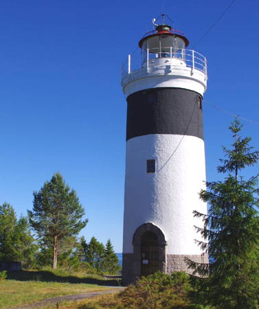
** Lungö (2)
1927 (station established 1861). Reactivated (inactive 1987-2001, now privately maintained); focal plane 29 m (95 ft); white light occulting once every 6 s. 15 m (49 ft) round concrete tower with lantern and gallery, mounted on a stone base. Lighthouse painted white with one black horizontal band; stone base unpainted. 1-1/2 story wood keeper's house and other station buildings preserved. A 2020 photo is at right, Trabas has a photo, Marinas.com has aerial photos, and Google has a satellite view. SFA has a historic photo of the original lighthouse. In 1996 the station was sold to two families from Härnösand, who restored and reactivated it. Located at the eastern end of the island of Lungön, where it marked the north side of the entrance to Härnösand. Site open, tower open to guided tours by arrangement with the owners. Owner/site manager: private. . ARLHS SWE-270; SV-1339; Admiralty C5988.5; NGA 10834.
Strömskaten (Strömskatan)
Date unknown (station established 1900). Active; focal plane 12 m (39 ft); two flashes every 12 s, white, red or green depending on direction. 11 m (36 ft) round cylindrical concrete tower with lantern and gallery, mounted on a square concrete base. Lighthouse painted red; the square base and lantern roof are painted white. Trabas has a photo and Google has a satellite view. Located at the western end of the island of Lungön. Site open, tower closed. SV-1352; Admiralty C5988; NGA 10832.
* Härnösands Hamn
1964 (station estalished 1919). Active; focal plane 8 m (26 ft); quick-flashing light, white, red or green depending on direction. 6.5 m (21 ft) round cylindrical concrete tower with octagonal lantern and gallery. Entire lighthouse painted red. Hartmann has a page for the light, Trabas has a closeup photo, Björn Wedin has a view from the sea and a 2017 closeup street view, and Google has a satellite view. Located on a point of land at the entrance to the inner harbor of Härnösand. Site open, tower closed. ARLHS SWE-184; SV-1356; Admiralty C6008; NGA 10828.
Härnöklubb (2)
2022 (station established 1927). Active; focal plane 31 m (102 ft); white, red or green light depending on direction, 2 s on, 2 s off, 6 s on, 6 s off. 6 m (20 ft) light atop a fiberglass cabinet, mounted on the round concrete base of the original light. Entire lighthouse is white. Trabas has a distant view of the earlier light, a 6.5 m (21 ft) round cylindrical concrete towe with lantern removed; Bing has an indistinct satellite view. Located on a promontory on the eastern end of the island of Härnön, about 5 km (3 mi) east southeast of Härnösand. Site status unknown. ARLHS SWE-182; SV-1342; Admiralty C6012; NGA 10820.
* Storholmen
1906. Active; focal plane 9 m (30 ft); two flashes every 6 s, white or red depending on direction. 4 m (13 ft) octagonal cast iron lantern mounted on a concrete pad. Lantern painted white. Trabas has a view from the sea and Google has a satellite view. Located at the southern tip of the island of Härnön, marking the start of the southern approach to Härnösand. Site open, tower closed. SV-1484; Admiralty C6014; NGA 10812.

Lungö Light, Härnösand, June 2020
Instagram photo by Anna's Lighthouses
Vänta Litetsgrund (Vänta Litets Grund)
1972. Active; focal plane 19 m (62 ft); white flash every 3 s. 19 m (62 ft) round concrete tower. Upper half of lighthouse painted red, lower half black. Marinas.com has aerial photos but the lighthouse is not shown in Google's satellite view. Located on a shoal in the Gulf of Bothnia about 20 km (12.5 mi) southeast of Härnösand. Accessible only by boat. Site open, tower closed. SV-1479; Admiralty C6015; NGA 10810.

Sundsvall Lighthouses
Rödögubben
1965. Active; focal plane 13 m (43 ft); white, red or green light depending on direction, occulting twice every 8 s. 12 m (39 ft) round cylindrical concrete tower with lantern and gallery. Upper half of lighthouse painted white, lower half black. Trabas has a view from the sea and Google has a satellite view. Located on an islet off the southeastern tip of the island of Rödön, about 13 km (8 mi) east of Sundsvall. Accessible only by boat. Site open, tower closed. ARLHS SWE-325; SV-1504; Admiralty C6021; NGA 10792.
Gubben
1965. Active; focal plane 15 m (49 ft); flash every 3 s, white, red or green depending on direction. 10 m (33 ft) round cylindrical concrete tower with lantern and gallery. Upper half of lighthouse painted red, lower half white. Trabas has a distant view and Google has a satellite view. In 2007 the light was reported to be scheduled for deactivation, but it remains on the active list. Located on a small island about 13 km (8 mi) east southeast of Sundsvall. Accessible only by boat. Site open, tower closed. ARLHS SWE-160; SV-1506; Admiralty C6022; NGA 10800.
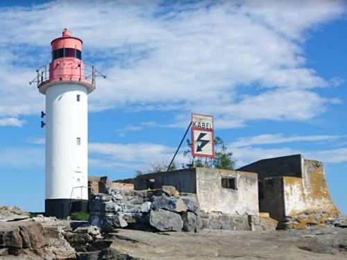
Draghällan (2)
1942 (station established 1878). Active; focal plane 13 m (43 ft); white, red or green light depending on direction, 1 s on, 1 s off, 3 s on, 5 s off. 13m (43 ft) round cylindrical concrete tower with lantern and gallery. Lighthouse painted white, lantern red. Peter Janulf's photo is at right, Hartmann has a page for the lighthouse, Trabas has a photo, Marinas.com has aerial photos, and Google has a satellite view. A former 2-1/2 story keeper's house was demolished after the light was automated in 1965. SFA has a photo of the original lighthouse and a photo of the current lighthouse with the keeper's house. Located on a small island in the center of the entrance to Sundsvall, about 6 km (3.5 mi) southeast of the city. Accessible only by boat. Site open, tower closed. ARLHS SWE-117; SV-1564; Admiralty C6036; NGA 10760.

Draghällan Light, Sundsvall, August 2018
Google Maps photo by Peter Janulf
* Brämön (2)
1948 (station established 1859). Active; focal plane 31 m (102 ft); white, red or green light depending on direction, 11.3 s on, 2.7 s off, 3.3 s on, 2.7 s off. 16 m (52 ft) round cylindrical concrete tower with lantern and gallery. The original 2nd order Fresnel lens, transferred from the former lighthouse, remains in use. Lighthouse painted with black and white horizontal bands. A photo by Joakim and Sandra Söderberg is at right, Sergey Ishkuvatov has a photo, Eric Felländer has a closeup, Marinas.com has aerial photos, and Google has a satellite view of the station. Huelse has a postcard view of the original stone lighthouse. The original lantern and lens were transferred from the old lighthouse to the present one. Located on the easternmost tip of Brämön. Site open, tower closed. ARLHS SWE-006; SV-1536; Admiralty C6030; NGA 10752.
Brämö Kalv
1946. Active; focal plane 12 m (39 ft); four flashes every 12 s, white, red or green depending on direction. 9 m (30 ft) round cylindrical concrete tower with lantern and gallery. Entire lighthouse painted white. Google has a satellite view. In 2007 the light was reported to be scheduled for deactivation, but this does not seem to have happened. Located on Brämö Kalv, a small island off the southwestern tip of the larger island of Brämön. Accessible only by boat. Site open, tower closed. ARLHS SWE-104; SV-1540; Admiralty C6041; NGA 10740.

Information available on lost lighthouses:

Brämön Fyr
Brämön Light, Sundsvall, 2008
ex-Panoramio photo copyright Joakim and Sandra Söderberg; used by permission

Notable faux lighthouses:

Adjoining pages: North: Western Bothnia | South: Southern Bothnia

Return to the Lighthouse Directory index | Ratings key

Posted August 13, 2007. Checked and revised November 12, 2023. Lighthouses: 23. Site copyright 2023 Russ Rowlett and the University of North Carolina at Chapel Hill.