Lighthouses of Seychelles

The Republic of Seychelles (pronounced Say-shells) includes several groups of islands (115 in all) scattered across the western part of the South Indian Ocean north of Madagascar. The Mahé group consists of rocky, fairly substantial islands and forms the core of the country; the other islands are mostly coral atolls and reefs. The first European settlements in the islands were by the French in the 1700s. The islands seesawed back and forth between Britain and France during the wars between those countries, finally landing in British hands for good in 1814. They were administered from Mauritius until 1903, when Seychelles became a separate colony. The country has been an independent republic and a member of the British Commonwealth since 1976. The population of the country is about 100,000.

English and French are official languages in Seychelles, but a French-based creole language is commonly spoken.

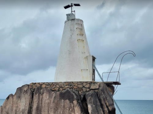
There are two historic lighthouses in Seychelles, the Denis Island Light seen at right and the Port Victoria Light shown below. Aids to navigation in Seychelles are maintained by the Seychelles Port Authority.

ARLHS numbers are from the ARLHS World List of Lights. Admiralty numbers are from volume D of the Admiralty List of Lights & Fog Signals. U.S. NGA List numbers are from Publication 112.

General Sources
Phares d'Afrique
A section of Le phare à travers le monde, the outstanding web site of Alain Guyomard and Robert Carceller; it includes links to several pages for Seychelles lighthouses. The Seychelles photos were contributed by Jean-Michel Penin.
Online List of Lights - Seychelles and Aldabra
Photos by various photographers posted by Alexander Trabas.
Lighthouses in Seychelles
Photos by various photographers available from Wikimedia.
World of Lighthouses - Seychelles
Photos by various photographers available from Lightphotos.net.
Seychelles Map
Useful for understanding the geography of this remote area.
Afrikanischen Leuchttürme auf historischen Postkarten
Historic postcard images posted by Klaus Huelse.
Leuchttürme auf Briefmarken
Huelse's extensive and useful page of lighthouse postage stamp images.
GPSNavigationCharts
Navigational chart information for the Seychelles.
Navionics Charts
Navigational chart for the Seychelles.

Denis Island Light, Octber 2022
Instagram photo by Denis Private Island
Denis Island Lighthouse
** Denis Island (3)
1910 (station established 1883). Reported inactive but listed with focal plane 37 m (121 ft); white flash every 5 s. 27 m (89 ft) skeletal tower with lantern and gallery, topped by a second skeletal tower. Access to the gallery is by an external stairway that zigzags up the legs of the lower tower. Lighthouse painted with red and white horizontal bands. A 2022 photo is at the top of this page, Dene Bebbington contributed a 2012 photo, Wikimedia has Adrian Scottow's 2010 photo, and Google has a satellite view. The skeletal extension was added in 1973; the two postage stamps at right show views before and after the extension. Lighthouse Digest has Michel Forand's postcard view of the tripod-style lighthouse built in 1892 to replace the original wood tower, which had detriorated quickly in the tropical climate. Huelse has the same postcard view. Denis Island is a small, privately owned coral island about 60 km (37 mi) north of Mahé. The island has been developed as a resort. Daniel Luconi has forwarded a message from the resort's sales manager, who says that the lighthouse "is no longer used for this purpose [navigation] and only serves as a remembrance of the Denis Island history." Located at the northern point of the island. Site open, tower reported open for climbing to the gallery. Owner/site manager: Denis Private Island. ARLHS SEY-002; Admiralty D6860; NGA 32844.
DEnis Island LightDenis Island Light
Denis Island Light on 1962 (left) and 1983 postage stamps
images courtesy of Klaus Huelse

Praslin and La Digue Lighthouses
Praslin is the second largest island of the Seychelles. Located 44 km (27 mi) northeast of Mahé, Praslin has a population of about 6,500. La Digue is a smaller island east of Praslin, separated from Praslin by a channel 4 km (2.5 mi) wide.
[Grande Anse]
Date unknown. Active; focal plane 3 m (10 ft); white flash every 3 s. 3 m (10 ft) square masonry tower. Ankur Achary has a distant street view from shore and Google has a satellite view. This light is the front beacon of a day range, the rear beacon being unlit. Located in the entrance to Grande Anse, an open anchorage on the south side of Praslin. Accessible only by boat. Site open, tower closed. Admiralty D6861; NGA 32832.
Pointe Zanguilles
Date unknown. Active; focal plane 16 m (52 ft); quick-flashing white light. Approx. 6 m (20 ft) square pyramidal white concrete tower. Zeger Zeilemaker's photo is at right, Trabas has Klaus Potschien's photo, Lightphotos.net has a view from the sea, and Google has a satellite view. Located on a rocky promontory on the north coast of Praslin Island, about 50 km (30 mi) northeast of Victoria. Accessible only by boat. Site open, tower closed. ARLHS SEY-009; Admiralty D6862.4; NGA 32828.
Pointe Cabris (Praslin Island)
Date unknown. Active; focal plane 16 m (52 ft); white flash every 10 s. Approx. 7 m (23 ft) white masonry tower. Trabas has Douglas Cameron's photo and Google has a satellite view. Located at the southeastern tip of Praslin Island, about 50 km (30 mi) northeast of Victoria. Site open, tower closed. ARLHS SEY-006; Admiralty D6862; NGA 32824.
[La Digue]
Date unknown. Active; focal plane 6 m (20 ft); white flash every 4 s. 3 m (10 ft) square cabinet with a short mast on top. Cabinet painted white. Trabas has Douglas Cameron's photo, Lightphotos.net has a good photo, and Google has an indistinct satellite view and a very distant street view from shore. Located on a reef just off the western tip of La Digue. Accessible only by boat. Site open, tower closed. ARLHS SEY-003; Admiralty D6863; NGA 32840.

Pointe Zanguilles Light, Praslin, October 2022
Google Maps photo by Zeger Zeilemaker

Mahé Island Area Lighthouses
The largest island of the Seychelles, Mahé includes the capital, Victoria, and has a population of about 95,000 (86% of the population of the country).

Mamelles Island (2?)
Date unknown (station established 1912). Active; focal plane 49 m (161 ft); white flash every 2.5 s. 6 m (20 ft) "white square stone structure" with a red roof, according to the NGA description. The light is barely visible atop the left peak in a distant view of the island, Trabas has Rainer Arndt's distant view of the island. Bing's satellite view also shows ruins of a keeper's cottage. The original light here was the 1892 tripod tower (seen in Michel Forand's postcard view) relocated from Denis Island. "Mamelles" is French for "breasts," which the island is said to resemble from a distance. Located on a small rocky island about 16 km (10 mi) northeast of the northern tip of Mahé. Accessible only by boat. Site open, tower closed. ARLHS SEY-005; Admiralty D6864; NGA 32820.
Sainte Anne Island
Date unknown. Active; focal plane 252 m (827 ft); continuous red light. 4 m (13 ft white building. No photo available but Google has a satellite view. Sainte Anne Island is located about 5 km (3 mi) northeast of Victoria, Mahé. Most of the heavily forested island is protected as a national park. Located on the summit of the island. Site status unknown. Admiralty D6865; NGA 32800.
Port Victoria Entrance
1877. Active; focal plane 12 m (39 ft); white flash every 6.7 s. 11 m (36 ft) masonry tower extended by a square skeletal tower. Masonry tower painted white, skeletal tower painted with red and white horizontal bands. Douglas Cameron's photo is at right, Trabas has Rainer Arndt's photo, Lightphotos.net has a good photo, Robert Wright has a photo, and Google has a satellite view. The lighthouse marks the entrance to the harbor of Victoria, the national capital, on the island of Mahé. In early 2007 the Ports Authority made repairs to the masonry structure. Endangered: In 2022 plans for a major expansion of the port called for destruction of the lighthouse, but after protests it appears contractors will be required to relocate it instead. Located about 3 km (2 mi) northeast of the Victoria waterfront. Accessible only by boat. Site open, tower closed. ARLHS SEY-004; Admiralty D6868; NGA 32796.
[Cape Ternay (Pointe Matoopa)]
Date unknown. Active; focal plane 21 m (69 ft); two quick white flashes every 10 s. Approx. 5 m (16 ft) conical white concrete tower. Google has an indistinct satellite view. Located at the western tip of Mahé. Probably accessible only by boat. Site and tower closed. ARLHS SEY-001; Admiralty D6871; NGA 32816.

Port Victoria Entrance Light, Victoria, January 2007
Seychelles government photo

Amirante Islands Lighthouses
The Amirante Islands are a chain of coral reefs, islands, and atolls extending in a north to south line about 240 km (150 mi) west southwest of Mahé.

African Banks (?)
Date unknown. Inactive since 2005 and apparently removed. This was an approx. 29 m (95 ft) square skeletal tower with gallery. The tower is not seen in Noel Jumeau's 2020 photo or Google's satellite view. The African Banks are a reef at the northern end of the Amirante Islands. The reef is famous for its rich seabird life. Accessible only by boat. Site open, tower closed. ex-Admiralty D6873; NGA 32780.
Desroches Island
Date unknown. Inactive since 2005. Approx. 29 m (95 ft) square skeletal tower with gallery. Alan Moolna has a 2011 photo but trees hide the tower in Google's satellite view. Desroches is the largest of the Amirante Islands, but it's only about 5.5 km (3.4 mi) long. It has a population of about 100. Located at the northeast end of the island. Accessible only by boat. Site open, tower closed. ex-Admiralty D6874; ex-NGA 32784.

Farquhar Group Lighthouse
The Farquhar Group consists of two atolls, Farquhar Atoll and Providence Atoll, located about 700 km (430 mi) southwest of Mahé.

Providence Island
Date unknown. Inactive since 2005. Approx. 29 m (95 ft) square skeletal tower with gallery. No photo available and the tower is not seen in Google's satellite view. Providence Island is at the northern end of Providence Island and of the Farquhar Group. Accessible only by boat. Site open, tower closed. ex-Admiralty D6877; ex-NGA 32788.

Aldabra Lighthouse
Aldabra West Island (1 and 2)
2013. Active; focal plane 17 m (56 ft); white flash every 2 s. 16 m (52 ft) round barbell-shaped fiberglass tower colored with red and white horizontal bands. David Stanley's photo is at right and Bing has a satellite view of the station. A light was formerly mounted on the circular water tank seen at the left in Stanley's photo. Aldabra is an atoll located 425 km (265 mi) northwest of Madagascar and more than 1100 km (700 mi) southwest of Mahé. The atoll is famous for its wildlife, especially the Aldabra giant tortoise. There is no permanent population but a scientific station managed by the Seychelles Islands Foundation is often occupied. Located at the scientific station near the northwestern corner of the atoll. Site and tower closed. Admiralty D6879; NGA 32778.

Information available on lost lighthouses:

Notable faux lighthouses:


Aldabra West Island Light, December 2016
Flickr Creative Commons photo by David Stanley

Adjoining pages: East: British Indian Ocean Territory | South: Madagascar

Return to the Lighthouse Directory index | Ratings key

Posted November 15, 2005. Checked and revised April 8, 2024. Lighthouses: 10. Site copyright 2024 Russ Rowlett and the University of North Carolina at Chapel Hill.