Lighthouses of the United States: Tennessee

The United States of America is a federal union of 50 states and a capital district. The state of Tennessee is located east of the Mississippi River and south of Kentucky. The state of North Carolina ceded the region of Tennessee to the federal government in 1790, and after a period as the Southwest Territory Tennessee was admitted to the Union as the 16th state in 1796. The state takes its name from the Tennessee River.

The state is divided officially into three regions called Grand Divisions: East Tennessee (including the cities of Knoxville and Chattanooga), Middle Tennessee (centered on the state capital, Nashville), and West Tennessee (including Memphis, on the Mississippi River, the state's largest city). Tennessee also has three navigable rivers. The Mississippi River flows southward along the western border of the state. The Tennessee River, made navigable to Knoxville by a series of major dams built by the Tennessee Valley Authority (TVA), flows southwestward from Knoxille past Chattanooga into Alabama and then returns northward forming the border between Middle and West Tennessee. The Cumberland River flows past Nashville before turning north into Kentucky; it is navigable past Nashville to the town of Celina.

The U.S. Coast Guard Sector Ohio Valley, based in Louisville, Kentucky, maintains navigation aids on the Tennessee and Cumberland Rivers.

To be listed here a lighthouse must actually serve as an aid to navigation. This means it must be located on a navigable lake or river and must be lit as a navigational aid at least during the local boating season.

USCG numbers are from Volume 5 of the U.S. Coast Guard List of Lights.
General Sources
U.S. Coast Guard Navigation Center: Light Lists
The USCG Light List can be downloaded in pdf format.
i-Boating NavigationCharts
Navigation chart information for Tennessee.
Navionics Chart
Navigation chart information for Tennessee.
 

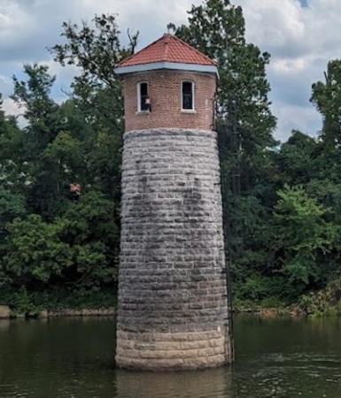
Omohundro Waterworks Light, Nashville, April 2018
ex-Google Plus photo by Jeremy Broadfoot
East Tennessee: Douglas Lake Lighthouse
* Lighthouse Pointe Marina (2)
Date unknown. Active; light characteristics unknown. 30 ft (9 m) round tower with lantern centered on a square gazebo-like pier building. Light tower painted in a red and white spiral pattern; building painted white with red trim and a red roof. A photo is available and Google has a satellite view. This appeared to be an active lighthouse. David McAfee visited in 2021 and reported that the lighthouse has disappeared. However Facebook photos from September 2022 show the lighthouse restored. Douglas Lake is a large Tennessee Valley Authority lake formed by damming the French Broad River in East Tennessee above Knoxville. Located on TN 139 about 7 mi (11 km) southwest of Dandridgße. Site open, tower closed. Owner/site manager: Lighthouse Pointe Marina .

East Tennessee: Tennessee River Lighthouses
Knoxville Utilities Water Intake
Date unknown. Active; focal plane about 33 ft (10 m); green flash every 6 s. Approx. 33 ft (10 m) square 3-story building. Google has a street view across the river and a satellite view. Located on the north bank of the river at the foot of Seneca Drive, east of downtown. Site and tower closed but the intake structure can be seen from the Island Home neighborhood across the river. Owner/site manager: Knoxville Utilities Board. USCG 5-29945.
Dupont Pumphouse
Date unknown. Active; focal plane about 12 m (39 ft); green flash every 6 s. Mast on a platform atop a round concrete structure. Google has a river view and a satellite view. Located on the west bank of the river about 1 mi (1.6 km) west of the Chickamauga Dam on the north side of Chattanooga. Accessible only by boat. Site open, tower closed. Owner/site manager: private. USCG 5-30950.
Hales Bar
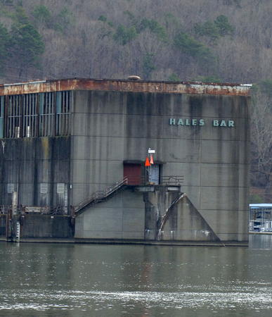
Date unknown. Active; focal plane about 12 m (39 ft); two red flashes every 5 s. Post carrying a red triangular daymark mounted on a stairway landing at the end of the Hales Bar Powerhouse. A photo is at right, the Tata & Howard Company has a photo, and Google has a river view and a satellite view. The Hales Bar Dam was completed by the Chattanooga and Tennessee River Power Company in 1913; it was the first major dam built on the Tennessee River. The Tennessee Valley Authority assumed ownership in 1939. TVA removed the dam in 1967-68 in favor of the new Nickajack Dam farther downstream, but the original powerhouse remains, projecting dangerously into the river. Located on the east bank of the river about 2 mi (3.2 km) north of the I-24 bridge, roughly 15 mi (25 km) west of Chattanooga. Accessible only by boat. Site open, tower closed. Owner/site manager: Tennessee Valley Authority. USCG 5-31230.


Hales Bar Light, Guild, December 2013
Wikimedia public domain photo by U.S. Army Corps of Engineers

Middle Tennessee: Cumberland River Lighthouse
Omohundro Waterworks Intake Crib
1889. Active; focal plane about 33 ft (10 m); two red flashes every 6 s. Approx. 12 m (39 ft) round brick tower with a wood pump room and a conical roof. The tower was originally painted white, but most of the paint has worn off; pump room painted red. The light is shown from a horizontal pole extended from one of the narrow windows of the pump room; it is visible on the left side of the tower in Don Vansant's 2007 photo. Jeremy Broadfoot's photo is at the top of this page, Jason Greene has a 2023 photo, Chris Cutler also has a photo (second large photo on the page), another photo is available, and Google has a satellite view. This historic tower stands in the Cumberland River just upstream from the Omohundro Waterworks of Nashville. The water intake remained in service until 1986, and in 1987 the tower was placed on the National Register of Historic Places. For many years it was in very poor condition with large holes in its roof, but Broadfoot's photo above and Jack Salcedo's 2018 photo show that it has been nicely restored. Located near the south bank of the river about 0.3 mi (500 m) east of the waterworks plant. Accessible only by boat; the best view is from Shelby Park on the north bank. Site open, tower closed. Owner/site manager: Nashville Metro Water Services. USCG 5-3785.

West Tennessee: Tennessee River Lighthouse
Browns Bluff
Date unknown. Active (?); focal plane 160 ft (49 m); continuous white light. 70 ft (21 m) round cylindrical 6-story wood residence with the lantern room atop a conical roof. Tower painted white; the conical roof is red and the lantern roof is black. Glen and Jill Moore have a photo (2/3 the way down the page), another photo is available, and Google has a satellite view. This unusual dwelling was built by Jerry Milam. Although its navigational value would be slight it is perched atop a steep limestone bluff and is a prominent landmark on the upper portion of Kentucky Lake. The Moores write that "it did actually function as an operating lighthouse for years," implying that it is no longer operational. Located at river mile 126.5 on Brown Bluff Lane about 15 mi (25 km) northeast of Parsons in Decatur County. Site and tower closed (private property).

Notable faux lighthouses:

Adjoining pages: North: Kentucky | South: Alabama

Return to the Lighthouse Directory index | Ratings key

Posted July 5, 2012. Checked and revised September 24, 2023. Lighthouses: 6. Site copyright 2023 Russ Rowlett and the University of North Carolina at Chapel Hill.