Lighthouses of Argentina: Río Negro and Chubut

Argentina (officially the Argentine Republic, República Argentina) is the second largest country of South America and has a population approaching 50 million. Located on the southern east coast of the continent, Argentina has a lengthy coastline on the South Atlantic Ocean, extending from the warm waters of the Río de la Plata to the edge of the cold Southern Ocean.

Colonized by Spain in the mid 1500s, Argentina secured its independence and territorial integrity in series of uprisings between 1810 and 18i6. Several decades of controversy and conflict established the organization of the country and its borders with its neighbors to the north. Between 1878 and 1884 Argentina expanded its control southward, occupying the region of Patagonia east of the Andes Mountains.

Argentina is a federation of 23 provinces (provincias) plus the autonomous capital city of Buenos Aires. This page includes lighthouses of the central part of mainland Argentina's South Atlantic coast in Río Negro and Chubut Provinces. These two provinces together include the northern half of Argentine Patagonia. The provinces are divided into counties called departments (departamentos).

The Spanish word for a lighthouse is faro; smaller lighthouses are often called balizas (beacons). In Spanish isla is an island, cabo is a cape, punta is a promontory or point of land, péñon is a rock, arrecife is a reef, bahía is a bay, ría is an estuary or inlet, estrecho is a strait, río is a river, and puerto is a port or harbor.

Active lighthouses in Argentina are owned by the Argentine Navy and managed by the Navy's Servicio de Hidrografía Naval (SHN).

ARLHS numbers are from the ARLHS World List of Lights. Admiralty numbers are from volume G of the Admiralty List of Lights & Fog Signals. U.S. NGA List numbers are from Publication 110, except for lights of the Beagle Channel, which are from Publication 111. The official Argentine light list, Faros y Señales Marítimas, is not available online.

General Sources
Lista de Faros Argentinos
Official SHN lighthouse site, with data and small photos. Unfortunately, it is not possible to link directly to the pages for individual lighthouses.
Faros de Argentina
Index to lighthouse articles and photos in the Spanish Wikipedia.
Faros Argentinos
Information and photos from the Argentine-based Faros del Mar website.
Lighthouses in Argentina
The ARLHS listing of Argentine lights; the society has photos for most of them.
Online List of Lights - Argentina
Photos by various photographers posted by Alexander Trabas.
Faros Argentina
Photos posted on Flickr.com by Carlos María Silvano. Several of his photos appear with his permission on this page.
World of Lighthouses - Argentina
Photos by various photographers available from Lightphotos.net.
Lighthouses in Argentina
Photos by various photographers available from Wikimedia.
Leuchttürme Südamerikas auf historischen Postkarten
Historic postcard views posted by Klaus Huelse.
GPSNauticalCharts
Navigational chart information for Argentina.
Navionics Charts
Navigation chart for Argentina.

Río Negro Light
Río Negro Light, Viedma, April 2011
Flickr photo copyright Carlos María Silvano; used by permission

Río Negro Province Lighthouses

Adolfo Alsina Department (Viedma Area) Lighthouses
** Río Negro ("Faro de la Boca")
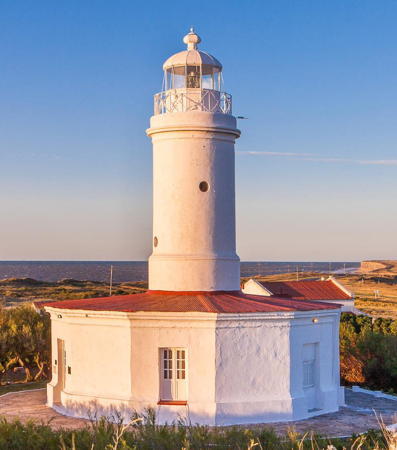
1887. Active; focal plane 43.5 m (143 ft); two white flashes every 20 s. 16.5 m (54 ft) round cylindrical brick tower with lantern and gallery rising from the center of a hexagonal 1-story brick keeper's quarters. Entire lighthouse painted white. Trabas has Silvano's photo (also seen at the top of the page), Walter Ibañez has a 2018 photo, Erik Schepers has another photo, Wikimedia has a photo of the station, and Google has a street view and a satellite view. The light station is staffed. This is Argentina's oldest surviving lighthouse and the first one to be built on the coast of Patagonia. The area is known locally as La Boca (the mouth), referring to the mouth of the Río Negro, which forms the boundary between Río Negro and Buenos Aires Provinces in the coastal region.However the river is not navigable, so the lighthouse acts instead as a landfall light for the Golfo San Matías to the south. At the beach close to the lighthouse is a memorial to Argentine service members killed in the Malvinas (Falklands) War of 1982. The lighthouse was opened to visitors starting in 2017. Located on the west side of the mouth of the Río Negro, adjacent to the El Cóndor resort; accessible via provincial route 1 from Viedma. Site open, lighthouse and tower open Friday, Saturday and Sunday. . ARLHS ARG-012; Admiralty G1028; NGA 19588.
Belén
1928. Inactive since 1992. 14 m (46 ft) square pyramidal steel skeletal tower formerly with a black and white slatted daymark. Lantern removed. Lucas Pedrazzi has a 2016 photo, ARLHS has a photo, and Google has a satellite view. Located on the Península Belén, at the northern entrance to the Golfo San Matías, about 110 km (70 mi) west of Viedma. Site open, tower closed. Owner/site manager: unknown. ARLHS ARG-069; ex-Admiralty G1030.

San Antonio Department Lighthouses
San Antonio Oeste is a port town with a population of about 16,000 located at the northwestern head of the Golfo San Matías, an elliptical bay sheltered on the south by the Península Valdés. Three ranges guides ships into the harbor area.

* San Matías
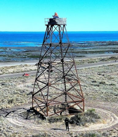
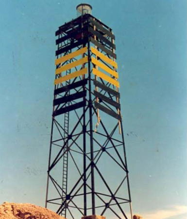
1924. Active; focal plane 42 m (138 ft); two white flashes every 11 s. 16 m (52 ft) square pyramidal steel skeletal tower with black and white slatted daymark. The lantern was removed in 1974, and the light is displayed from a platform at the top of the tower. Trabas has Silvano's photo seen at right, Leandro Cottet has a 2021 photo, Lightphotos.net has a photo, Jorge Luis Bilbao has a photo, and Google has a satellite view. The lighthouse is built atop an artificial dune: a large conical mound. The surrounding area is a nature preserve, the Área Natural Protegida Bahía de San Antonio. Located off National Route 3 on the northeast side of the Golfo San Matías, perhaps 30 km (20 mi) east of San Antonio Oeste. Site open, tower closed. ARLHS ARG-064; Admiralty G1031; NGA 19596.
Punta Villarino
1911. Active; focal plane 34 m (112 ft); white flash every 6 s. 7 m (23 ft) triangular skeletal tower. Martin Mendoza has a closeup 2023 photo, Daniel Ramallo has a 2013 photo, ARLHS has a photo, and the shadow of the light is centered in a Google satellite view. Located on a low point of land sheltering the port area of San Antonio Oeste. Site open, tower closed. ARLHS ARG-072; Admiralty G1038; NGA 19598.
* Pedro Garcia Range Rear
Date unknown. Active; focal plane 39 m (128 ft); green flash every 3 s. 24 m (79 ft) round water tank, painted with vertical black and white stripes. Trabas has Silvano's photo, Cándido Héctor García has a photo, and Google has a satellite view. This is the approach range guiding vessels arriving at San Antonio Oeste. Located on a peninsula sheltering the harbor. Accessible by road. Site open, tower closed. ARLHS ARG-138; Admiralty G1035; NGA 19601.
Cangrejal Inner Range Front
Date unknown. Active; focal plane15 m (49 ft); white flash every 2 s. 15 m (49 ft) square skeletal tower carrying an orange rectangular daymark panel. Trabas has Silvano's distant view and Bing has a satellite view. This the third range for San Antonio Oeste harbor. Located in a marsh east of the port, 4 km (2.5 mi) south of the rear light (next entry). Site status unknown. Admiralty G1042; NGA 19612.
 

San Matías Light, San Antonio Oeste
photo copyright Carlos María Silvano; used by permission
* Camino (Cangrejal Inner Range Rear)
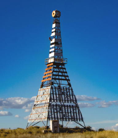
Date unknown. Active; focal plane 24.5 m (80 ft); red flash every 4 s. 23 m (75 ft) square pyramidal skeletal tower carrying a slatted daymark painted white with red bars in the center. A 2021 photo is at right, Trabas has Silvano's photo, and Google has a street view and a satellite view. This is an entrance range for San Antonio Oeste. Located just off National Route 3 on the north side of the Bahía San Antonio. Site open, tower closed. Admiralty G1042.1; NGA 19616.
Banco Reparo Range Front
Date unknown. Active; focal plane 15 m (49 ft); white flash every 2 s. 15 m (49 ft) square skeletal tower carrying several daymarks including a triangular daymark point up. No photo available but Bing has a satellite view. This is the second range for San Antonio Oeste. Located in a shallow area off the west side of the entrance channel. Accessible only by boat. Site open, tower closed. Admiralty G1036; NGA 19604.
* Banco Reparo Range Rear
Date unknown. Active; focal plane 41 m (135 ft); red flash every 3 s. 24 m (79 ft) square cylindrical skeletal tower. The front of the tower has a daymark of black and white bars. Trabas has Silvano's photo and Google has a satellite view and a distant street view. Located on a peninsula about 5 km (3 mi) southeast of San Antonio Oeste. Accessible by road. Site open, tower closed. ARLHS ARG-149; Admiralty G1037; NGA 19608.
* Las Grutas
Date unknown. Active; focal plane 71 m (233 ft); white light, 1 s on, 1 s off. 30 m (98 ft) round cylindrical water tank. Google has a street view and a satellite view. Located in Las Grutas, a beach resort town about 15 km (9 mi) south of San Antonio Oeste. Site open, tower closed. ARLHS ARG-115; Admiralty G1045; NGA 19626.
Punta Colorada
Date unknown. Reactivated; focal plane 54 m (177 ft); white light, 2 s on, 2 s off, 2 s on, 4 s off. Light mounted on a large industrial building. Armando Poujol has a photo and Google has a satellite view. This light guides vessels arriving to load iron ore at a facility formerly abandoned but recently revived by a Chinese company. Located at Punta Colorada, about 100 km (60 mi) south of Las Grutas. Site status unknown. Admiralty G1046.3; NGA 19628.

Camino Light, San Antonio Oeste, March 2021
Google Maps photo by Ground Training

Chubut Province Lighthouses

Biedma Department: Península Valdés Lighthouses
The Península Valdés is an elliptical near-island about 100 km (60 mi) from north to south and 75 km (46 mi) east to west, separating the Golfo San Matías on the north and the Golfo Nuevo on the south. On the north coast of the peninsula a narrow inlet leads to an elliptical bay, the Golfo San José, that leaves only a narrow isthmus to connect the peninsula to the mainland. The peninsula is mostly deserted except for a few sheep ranches; most of it is protected as a nature reserve. Puerto Madryn, at the head of the Golfo Nuevo, is the administrative center of Biedma department and the only town of any size in the area.
Punta Quiroga
Date unknown. Active; focal plane 40 m (131 ft); white flash every 10 s. 6 m (20 ft) square post rising from a square 1-story equipment shelter. Lighthouse painted with black and white horizontal bands. Enrique Pidal has a 2020 closeup photo and Google has an indistinct satellite view. Located on a promontory about 800 m (1/2 mi) west of the entrance to the Golfo San José on the north side of the Península Valdés. Site open, tower closed. Admiralty G1047; NGA 19632.
Punta Tehuelche
1949. Active; focal plane 35 m (116 ft); three white flashes every 20 s. 12 m (39 ft) square pyramidal concrete skeletal tower with lantern and a 1-story enclosed concrete workroom in the base. Alejandro Luppi's 2019 photo is at right, he also has a more distant view, Alejandro Luppi has a 2021 closeup, Trabas has Silvano's very distant view, and Google has a satellite view. Located on a promontory projecting into the Golfo San José on the north side of the Istmo Ameghino, the narrow neck of land connecting the Península Valdés to the mainland. Accessible only by boat; there is no road access to this site. Site open, tower closed. ARLHS ARG-059; Admiralty G1048.8; NGA 19636.
Sarmiento
Date unknown. Active; focal plane 19 m (62 ft); two white flashes every 10 s. 5 n (16 ft) round cylindrical concrete tower painted with red and white horizontal bands. No photo available but Google has a satellite view. Located on the northeast side of the Golfo San José. Site status unknown. ARLHS ARG-092; Admiralty G1048.4; NGA 19638.
Punta Buenos Aires
Date unknown. Active; focal plane 38 m (125 ft); white flash every 3 s. 6 m (20 ft) square tower rising from a 1-story square equipment building. Lighthouse painted in an unusual red and white checkerboard pattern. Enrique Pidel has a 2020 closeup photo, José Pavoni also has a closeup photo, and Google has a satellite view. Located on a promontory near the tip of the Península Buenos Aires, the long peninsula enclosing the northeast side of the Golfo San José. Accessible by 4WD. Site open, tower closed. ARLHS ARG-093; Admiralty G1048; NGA 19634.
Almirante Brown (2)
1949. Active; focal plane 76.5 m (251 ft); two white flashes, separated by 4 s, every 16 s. 5 m (17 ft) square cylindrical concrete tower, painted white with a daymark of red horizontal bars and a red "bull's-eye." Light displayed from a small lantern on a short mast. ARLHS has a closeup photo and Bing has a satellite view. A wooden tower built here in 1945 collapsed in 1948. Located on the northern coast of the Península Buenos Aires, about 13 km (8 mi) east of Punta Buenos Aires and the entrance to the Golfo San José. Accessible only by boat or helicopter; there is no road access to this site. Site and tower closed. ARLHS ARG-018; Admiralty G1049; NGA 19640.

Punta Tehuelche Light, Península Valdés, October 2019
Google Maps photo by Alejandro Luppi
* Punta Norte
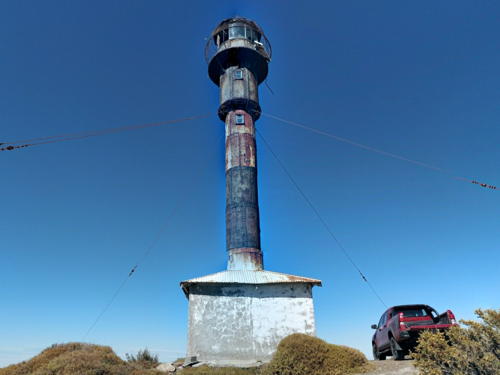
1925. Active; focal plane 62.5 m (205 ft); white flash every 10 s. 16.5 m (54 ft) slender round cylindrical metal (cast iron?) tower with lantern, rising from the center of a small workroom. Lighthouse painted with black and white horizontal bands. Guy wires have been added to steady this weatherbeaten and rather fragile-looking tower. Endangered by many years of poor maintenance. Enrique Pidel has a 2020 closeup photo, ARLHS has a photo, Fabio Dornelles has a 2007 photo, Trabas has Silvano's photo, and Google has a satellite view. As an experiment the light was powered by the wind from 1982 to 1990; it is now solar powered. The area is well known for its wildlife, especially elephant seals. Located at the northernmost point of the Península Valdés marking the southern entrance to the Golfo San Matías. Accessible at the end of provincial route 3, 75 km (47 mi) northeast of Puerto Pirámides. Site open, tower closed. ARLHS ARG-056; Admiralty G1050; NGA 19652.
* [Punta Bajos (2)]
2001 (station established 1927). Active; focal plane 27 m (89 ft); white flash every 3 s. Approx. 25 m (82 ft) triangular cylindrical skeletal mast. Trabas has Silvano's photo, ARLHS has a photo, and Google has a satellite view. The original lighthouse here was a 28 m (92 ft) square skeletal iron tower. Located beside the coastal road on the east coast of the peninsula, midway between the Punta Norte and Punta Delgada lighthouses. Site open, tower closed. ARLHS ARG-051; Admiralty G1052; NGA 19656.
**** Punta Delgada
1905 (Pablo Texera García and Guillermo Cray). Active; focal plane 71 m (234 ft); three white flashes in a 2+1 pattern every 25 s. 14 m (46 ft) round cast iron tower with lantern and gallery, painted brick red; lantern painted black. Fresnel lens in use. The light station is staffed. Linda De Volder's photo is at right, Trabas has Hendrik Martin Porath's closeup photo, Faros del Mar has a page with a great photo, Sergio Agustin Obiol has a 2023 closeup, Wikimedia has a fine 2005 photo, Stefano Paradisi has a 2008 photo, a 2007 closeup photo is available, and Google has a satellite view and a closeup street view. The development of ecotourism on the Península Valdés has made this one of the best known lighthouses in Argentina (or in South America, for that matter). The buildings of the light station include a hotel and restaurant. The surrounding area has one of the world's largest elephant seal colonies as well as many other kinds of wildlife. Located at the southeastern tip of the Península Valdés, about 65 km (40 mi) southeast of Puerto Pirámides on provincial route 2. Site open, tower open for tours daily. Site manager: Faro Punta Delgada Hotel. . ARLHS ARG-015; Admiralty G1054; NGA 19660.
Morro Nuevo
1918. Active; focal plane 118 m (387 ft); white flash every 5s. 12 m (39 ft) square pyramidal steel skeletal tower painted with red and white horizontal bands. Lantern removed. Trabas has Erich Hartmann's view from the sea and Google has an indistinct satellite view. ARLHS has an older photo showing the tower when it was painted brown. This light and the Punta Ninfas lighthouse (see below) bracket the entrance to the Golfo Nuevo, the large bay on the south side of the Península Valdés. The lighthouse was converted to wind power in 1982 but the experiment failed; it was converted to solar power in 1984. Located atop a high headland at the southernmost point of the Península Valdés, marking the northern entrance to the Golfo Nuevo. There is no road access to this site. Site open, tower closed. ARLHS ARG-049; Admiralty G1058; NGA 19664.
* Puerto Pyrámides
Date unknown. Active; focal plane 87 m (285 ft); white flash every 3 s. 6 m (20 ft) square cylindrical concrete skeletal tower, lower portion enclosed. The tower is white concrete with three narrow red horizontal bands. Trabas has Silvano's photo and Google has a satellite view. Puerto Pyrámides is the only town on the Península Valdés; it has a population of about 550. Located on a hillside above the town, on the south side of the peninsula. Site open, tower closed. Admiralty G1060; NGA 19724.

Punta Delgada Light, January 2017
Flickr Creative Commons photo by Linda De Volder

Biedma Department: Puerto Madryn Area Lighthouses
Puerto Madryn is a city of about 100,000 residents, the commercial and tourist center for the Biedma Department and Península Valdés. The city is on the western coast of the Golfo Nuevo, a large bay sheltered between the Península Valdes and the peninsula of Punta Ninfas.

*
Punta Flecha (Puerto Madryn)
Date unknown. Active; focal plane 42 m (138 ft); white flash every 9 s. 13 m (43 ft) square pyramidal skeletal tower, with two sides covered with a slatted daymark painted red with one white vertical stripe. Trabas has Silvano's closeup photo, Jorge Gobbi also has a photo, and Google has a street view and an indistinct satellite view. This light probably replaced the Golfo Nuevo lighthouse (next entry). Located atop a steep headland just off highway 42 about 15 km (9 mi) northeast of Puerto Madryn. Site open, tower closed. ARLHS ARG-089; Admiralty G1064; NGA 19696.
* Puerto Madryn (Golfo Nuevo)
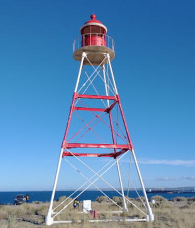
1916. Inactive since about 1990. 14.5 m (48 ft) square pyramidal skeletal tower with lantern and gallery, painted with red and white horizontal bands. A 2021 photo is at right. Federico Trevisan has a good photo, ARLHS has a photo, Carlos Zelayeta has a closeup photo, Juan Targarelli has a street view, and Google has a satellite view. Public protests saved this lighthouse when the Navy announced in 1990 its plan to remove the tower. The lighthouse is a traditional symbol of the city of Puerto Madryn, which carried out a restoration around 2020. Located in an industrial area just north of the city. Site open, tower closed. Owner/site manager: Municipalidad de Puerto Madryn. ARLHS ARG-038.
* Ecocentro Mar Patagonia
Date unknown. Inactive since 2011; charted as a landmark. 13 m (43 ft) octagonal tower attached to a 1-story ecological center; the light is (was?) perched atop the pyramidal roof of the tower. The building is white. Gerardo Bartolome has a photo, Gabriel Rosito has a photo, Leandro Garcia has a street view, and Google has a satellite view. Located on a headland on the south side of Puerto Madryn. Site and building open. Owner/site manager: Ecocentro Mar Patagonia. ex-Admiralty G1065; ex-NGA 19690.
* Acantilado (Puerto Madryn)
Date unknown. Active; focal plane 57 m (187 ft); white flash every 6 s. 13 m (43 ft) square pyramidal skeletal tower; two sides of the tower are covered with a slatted daymark painted red with one white horizontal band. Trabas has Erich Hartmann's photo, Andrea Aramayo has a 2019 photo, Pablo Ayala has a street view, and Google has a satellite view. Located on the east side of a promontory about 8 km (5 mi) southeast of Puerto Madryn. Site open, tower closed. ARLHS ARG-088; Admiralty G1066; NGA 19688.

Puerto Madryn Light, Puerto Madryn, Febrauary 2021
Google Maps photo by Ground Training

Rawson Department Lighthouses
Punta Conscriptos (2)
1986 (station established 1929). Active; focal plane 97 m (318 ft); white flash every 7 s, except every third flash omitted. 10 m (33 ft) square broadly pyramidal skeletal tower, painted black. Trabas has Silvano's photo, ARLHS has a photo, and Google has an indistinct satellite view. The cape got its name when the original light was built by a work crew of military conscripts. Located atop a steep cliff about 800 m (1/2 mi) south of Punta Conscriptos, a promontory about 30 km (19 mi) southeast of Puerto Madryn. Site open but probably difficult to reach, tower closed. ARLHS ARG-052; Admiralty G1072; NGA 19684.
Punta Cracker (Captain Rodriguez)
Date unknown. Active; focal plane 83 m (272 ft); white flash every 8 s. 7 m (23 ft) square skeletal tower painted with red and white horizontal bands. Trabas has Silvano's distant view and Google has an indistinct satellite view. Located atop a steep bluff halfway between Puerto Madryn and Punta Conscriptos. Site status unknown. ARLHS ARG-112; Admiralty G1073.4; NGA 19680.
* Punta Ninfas (2)
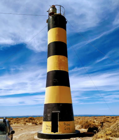
1971 (station established 1916). Active; focal plane 90 m (295 ft); two white flashes every 20 s. 12 m (39 ft) round fiberglass tower, colored with black and yellow horizontal bands. No lantern. Guy wires steady the tower. Daniel Sanso's photos is at right, Trabas has Silvano's photos, Fabien Dany has a 2007 photo, a 2008 closeup is available, and Google has a street view and a satellite view. This lighthouse replaced a 15 m (48 ft) octagonal skeletal tower. Located on the point marking the southern entrance to the Golfo Nuevo, at the end of provincial route 5 about 50 km (30 mi) east of Puerto Madryn. Site open, tower closed. . ARLHS ARG-055; Admiralty G1074; NGA 19668.
* Chubut (Río Chubut, Punta del Faro)
1933. Active; focal plane 36.5 m (120 ft); white flash every 9 s. 11.5 m (38 ft) square pyramidal steel skeletal tower, painted black, with black and white slatted daymark. Lantern removed 1985. Trabas has Silvano's photo, ARLHS has a photo, and Bing has a satellite view. Located on a headland about 3 km (1.8 mi) south of the mouth of the Río Chubut and about 10 km (6 mi) south of the provincial capital of Rawson on the coastal road to Playa Santa Isabel. Site open, tower closed. ARLHS ARG-034; Admiralty G1076; NGA 19728.

Punta Ninfas Light, Puerto Madryn, February 2021
Google Maps photo by Daniel Sanso

Florentino Ameghino Department Lighthouses
Punta Lobos ("Seal Point")
1948. Active; focal plane 145 m (477 ft); two white flashes, separated by 5 s, every 15 s. 11 m (36 ft) round concrete tower with lantern and gallery, painted with narrow horizontal red and white bands; lantern and gallery are red. ARLHS has a photo and Google has a satellite view. Sibling of Faro Cabo Dañoso (see below). This lighthouse stands in a barren area with no road access. Located high on a prominent headland about 65 km (40 mi) south of Rawson. Site open, tower closed. ARLHS ARG-053; Admiralty G1080; NGA 19740.
Cabo Raso ("Flat Cape")
1925. Active; focal plane 54 m (177 ft); three flashes separated by 7 s, white or red depending on direction, every 40 s. 23 m (75 ft) 2-stage square pyramidal skeletal tower with slatted daymark; entire lighthouse painted white. Guy wires steady the tower. Trabas has Silvano's photo, a distant view is available, and Google has a satellite view. The tower has an unusual profile; it appears that at some time the tower height was raised by replacing the lantern with a second skeletal tower mounted on the original gallery. However the active light is at the top of the lower pyramid. Located on the cape about 100 km (65 mi) south of Rawson. Accessible by a dirt road. Site open, tower closed. ARLHS ARG-029; Admiralty G1084; NGA 19744.
San José (Cabo San José) (3)
1974 (station established 1917). Active; focal plane 84 m (276 ft); flash every 5 s, white or red depending on direction. 16.5 m (54 ft) square pyramidal skeletal tower caarying on two sides a slatted daymark painted black with one yellow horizontal band. Juan Pablo Giacalone's photo is at right, the tower is unpainted in the 2005 ARLHS photo and Google has a good satellite view. The original lighthouse was a round cast iron tower with lantern and gallery; it was replaced in 1932. Located atop a prominent cape about 18 km (11 mi) south of Cabo Raso and 40 km (25 mi) northeast of Camerones. There is no road access to this site. Site open, tower closed. ARLHS ARG-063; Admiralty G1086; NGA 19748.
Puerto Santa Elena
Date unknown. Active; focal plane 21 m (69 ft); flash every 7 s, white or red depending on direction. 7 m (23 ft) square pyramidal skeletal tower painted with black and white horizontal bands. No photo available but Google has a satellite view. The bay of Santa Elena is a protected harbor of refuge in the lee of Cabo San José. Located on a rocky headland in the bay. There is no road access to this site. Site open, tower closed. Admiralty G1087; NGA 19752.

Cabo San José Light, Camerones, October 2013
Google Maps photo by Juan Pablo Giacalone
* [Camerones]
Date unknown. Active; focal plane 22 m (72 ft); flash every 5 s, white or red depending on direction. 4 m (13 ft) round fiberglass tower, upper half red and lower half yellow. Trabas has Silvano's photo and Google has a street view and a satellite view. Camerones is a fishing village of about 1000 residents and the seat of the Department. Located on a hillside above the harbor of Camerones. Site open, tower closed. Admiralty G1089; NGA 19760.
Bahía San Gregorio
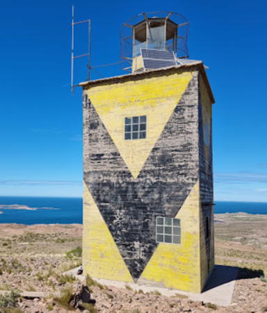
1968. Active; focal plane 172 m (564 ft); white flash every 5.2 s. 9 m (30 ft) square cylindrical concrete block tower with lantern and gallery. Lighthouse painted yellow with a broad black "V" on each face, making a zigzag pattern around the building. An SHN photo is at right, Victor Bonzano has a 2021 photo, Trabas has Silvano's distant photo, and Google has a good satellite view. This lighthouse replaced the Isla Leones Light. Located about 13 miles south of Camerones on the heights of the Cabo Dos Bahías, the northern entrance to the Golfo San Jorge. There is no road access to this rugged area. Site open, tower closed. ARLHS ARG-062; Admiralty G1089.4; NGA 19764.
Isla Leones
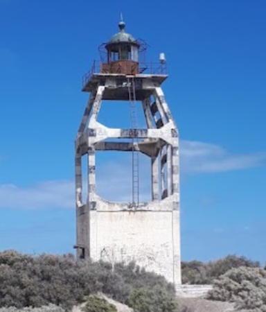
1917. Inactive since 1968. 12.5 m (41 ft) round cylindrical tower with lantern and gallery centered atop a 1-story octagonal concrete block keeper's quarters. ARLHS has a closeup photo, Carolina Almeida has a 2019 photo, Andrés Moreno has a 2021 photo, and Google has an excellent satellite view of the station. Isla Leones lies off the Cabo Dos Bahías; the light was abandoned due to the difficulties of landing men and supplies on the island. The lighthouse is clearly endangered and beginning to fall into ruin. Accessible only by boat or helicopter. Site open, tower closed. ARLHS ARG-071.
[Isla Rasa (2)]
1930 (station established 1917). Active; focal plane 23 m (75 ft); white flash every 8 s. 6 m (20 ft) post painted black. Some small buildings survive from the original light station. SHN has a photo and Bing has a satellite view. The original lighthouse was a 7.5 m (25 ft) round cast iron tower. Located on a tiny islet about 20 km (13 mi) east southeast of Isla Leones. Accessible only by boat. Site open, tower closed. ARLHS ARG-041; Admiralty G1092; NGA 19768.

Escalante Department Lighthouses
Bahía Bustamante
Date unknown. Active; focal plane 102 m (335 ft); white flash every 10 s. 6 m (20 ft) square skeletal tower supposedly carrying a daymark panel painted with red and white chevrons. There's no daymark seen in a 2008 photo by Jorge Luis Bilbao. Google has a satellite view. Located atop a steep bluff about 400 m (1/4 mi) south of the tiny village of Bahía Bustamante. Site open, tower closed. ARLHS ARG-128; Admiralty G1096; NGA 19776.
Punta Ulloa
Date unknown. Active; focal plane 35 m (115 ft); two white flashes every 15 s. 7 m (23 ft) square pyramidal skeletal tower painted black. No photo available but Bing has a satellite view. Located on a sharp point on the south side of the entrance to the Bahía Bustamante. Site open, tower closed. Admiralty G1095; NGA 19784.
Faro de San Gregorio
Bahía San Gregorio Light, Camerones
Servicio de Hidrografía Naval photo
Cabo Aristizábal (1-2)
1917 (rebuilt 1977). Active; focal plane 46 m (151 ft); white flash every 5 s. 16 m (52 ft) square skeletal tower, painted black; enclosed inside is the original skeletal tower. The upper half of the tower is supposed to be at least partially enclosed by a slatted daymark painted with red and white chevrons. SHN has a small photo showing the daymark but it's missing in Jorge Luis Bilbao's 2008 photo. Bing has a satellite view. Located on a prominent and rugged cape about 8 km (5 mi) south of Bahía Bustamante. Accessible only by boat or helicopter. Site open, tower closed. ARLHS ARG-023; Admiralty G1097; NGA 19788.
Caleta Córdoba Second Range Front
Date unknown. Active; focal plane 53 m (174 ft); quick-flashing white light. 11 m (36 ft) square pyramidal skeletal tower (?). Gustavo Koszel's distant street view from the beach appears to show the top of a masonry tower. Bing's distant satellite view and Google's fuzzy satellite view are not very informative. Caleta Córdoba is a small port handling petroleum exports. This range guides vessels leaving the port. Located atop a ridge on the north side of the town's harbor. Site status unknown. Admiralty G1102; NGA 19804.
Caleta Córdoba Second Range Rear
Date unknown. Active; focal plane 79 m (259 ft); white flash every 3 s. 11 m (36 ft) square pyramidal skeletal tower. No photo available but Bing has a distant satellite view. Located 260 m (850 ft) north of the front light. Site status unknown. Admiralty G1102.1; NGA 19808.
* Astra (Caleta Córdoba First Range Front)
Date unknown. Active (?); focal plane 40 m (131 ft); quick-flashing red light. 11 m (36 ft) square pyramidal skeletal tower carrying a black and white daymark. Google has a street view and a satellite view. This is the entrance range for the port. Located on a hill above the northern part of the town. Accessible by road. Site open, tower closed. Admiralty G1100; NGA 19796.
Loma Blanca (Caleta Córdoba First Range Rear)
Date unknown. Active; focal plane 55 m (180 ft); white flash every 3 s. 11 m (36 ft) square pyramidal skeletal tower painted red. Google has a distant street view and Bing has an indistinct satellite view. Located 700 m (0.44 mi) west of the front light. Site status unknown. Admiralty G1100.1; NGA 19800.
* Cabo San Jorge
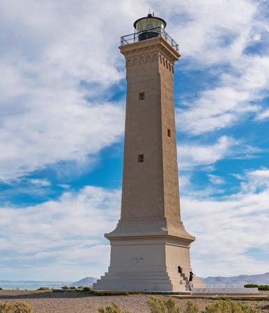
1925 (Santiago Orengo). Active; focal plane 78 m (256 ft); four white flashes, separated by 5 s, every 32 s. 27 m (89 ft) square brick tower with lantern and gallery, painted white; lantern and gallery painted black. A photo is at right, Juan Manuel Hawkes has the 2018 photo seen at right, Wikimedia has a photo, a 2008 photo is available, Néstor Galina has a sunset photo, Huelse has a historic postcard photo, and Google has a street view and a satellite view. Located about 13 km (8 mi) north of Comodoro Rivadavia, the southernmost city of Chubut. Accessible by road. Site open, tower closed. . ARLHS ARG-006; Admiralty G1104; NGA 19792.
Comodoro Rivadavia Range Front (Edificio)
Date unknown. Active; focal plane about 20 m (66 ft); white light, 1.5 s on, 1.5 s off. Approx. 15 m (49 ft) square cylindrical white tower rising from a 1-story terminal office building. Julio Arenas has a photo and Google has a satellite view. Comodoro Rivadavia (Comodoro for short) is the largest city in Chubut Province and one of the most important ports of southern Argentina. Located at the base of a 1 km (0.6 mi) long oil loading pier. Site and tower closed. Owner/site manager: Puerto Comodoro Rivadavia. Admiralty G1112.
Comodoro Rivadavia Range Rear (Chimanea)
Date unknown. Active; focal plane 79 m (259 ft); white light occulting once every 3 s (possibly synchronized with the front light). Approx. 50 m (164 ft) round cylindrical white chimney. Alberto Azparren has a distant view and Google has a street view and a satellite view. Located about 250 m (1/6 mi) northwest of the front light. Site and tower closed. Owner/site manager: Puerto Comodoro Rivadavia. Admiralty G1114.

Cabo San Jorge Light, Comodoro Rivadavia, February 2018
Google Maps photo by Juan Manuel Hawkes

Information available on lost lighthouses:

Notable faux lighthouses:

Adjoining pages: North: Buenos Aires | East: Falkland Islands | South: Santa Cruz

Return to the Lighthouse Directory index | Ratings key

Posted December 2003. Checked and revised July 4, 2023. Lighthouses: 44. Site copyright 2023 Russ Rowlett and the University of North Carolina at Chapel Hill.