Lighthouses of France: Southern Finistère

France (officially the French Republic, République française) has coasts facing south on the Mediterranean Sea, west on the open Atlantic Ocean, and north on the English Channel (La Manche in French). Long a leader in lighthouse design, France has scores of famous and historic lighthouses. And it was a French engineer and physicist, Augustin-Jean Fresnel (1788-1837), who invented the powerful and beautiful lenses used in lighthouses around the world.

France's Département du Finistère (Department of the End of the World) occupies the rugged western end of the peninsula of Bretagne (Brittany), one of the 12 administrative regions (régions) of Mainland France. Its dangerous coastline is crowded with lighthouses, more than in any other region of France. So many, in fact, that the Directory needs three pages to cover them all. This page includes lighthouses on the southern coast of the département, south and southeast of Brest. Most of this coast faces south on the Bay of Biscay (known in France as the Golfe de Gascogne).

The French word for a lighthouse, phare, is often reserved for the larger coastal lighthouses; a smaller light or harbor light is called a feu (literally "fire," but here meaning "light") or a balise (beacon). The front light of a range (alignement) is the feu antérieur and the rear light is the feu postérieur. In French île is an island, cap is a cape, pointe is a promontory or point of land, roche is a rock, récife is a reef, baie is a bay, estuaire is an estuary or inlet, détroit is a strait, rivière is a river, and havre is a harbor. The Breton word for a lighthouse is tour-tan; enez is an island, and men is a rock or reef.

Aids to navigation in France are maintained by the Bureau des Phares et Balises, an agency of the Direction des Affaires Maritimes (Directorate of Maritime Affairs). The Directorate has four regional offices (called Directions Interrégionale de la Mer, or DIRM) at Le Havre, Nantes, Bordeaux, and Marseille. Lights in Brittany are managed by the DIRM Nord-Atlantique - Manche Ouest at Nantes.

ARLHS numbers are from the ARLHS World List of Lights. FR numbers are the French light list numbers, where known. Admiralty numbers are from volume D of the Admiralty List of Lights & Fog Signals. U.S. NGA List numbers are from Publication 113.
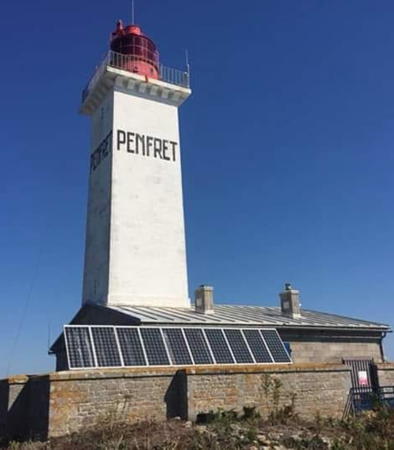

Île Penfret Light, Archipel des Glénan, May 2020
Instagram photo by Serge Caredda

General Sources
DIRM - Phares du Finistère
Information on the major historic lighthouses.
Les Sentinelles des Mers - France - Bretagne
Photos and information posted by Guy Detienne.
Le Phare à travers le Monde
A large, well known site maintained by Alain Guyomard and Robert Carceller.
Les Phares de France
Another large and well known site, this one by Jean-Christophe Fichou.
Phares et Balises: Silhouettes
Photos and information posted by M. Mocquant.
Online List of Lights - France - Atlantic Coast
Photos by various photographers posted by Alexander Trabas. Many photos for this area are by Capt. Peter Mosselberger ("Capt. Peter").
Leuchttürme.net - Frankreich
Photos and notes by Malte Werning.
Lighthouses in Finistère
Photos by various photographers available from Wikimedia.
Lighthouses in France
Aerial photos posted by Marinas.com.
Liste des phares du Finistère
From the French language Wikipedia, this page has a map of Finistère showing the locations of the lighthouses.
Seeing Lighthouses in Brittany and Île d'Ouessant
Photos and English language text by Rick Chinn, including a useful chart of visitable lighthouses.
Société Nationale pour le Patrimoine des Phares et Balises (SNPPB)
The French national lighthouse preservation organization.
Französische Leuchttürme und Baken auf historischen Postkarten
Historic photos and postcard images posted by Klaus Huelse.
GPSNauticalCharts
Navigational chart information for Finistère.
Navionics Charts
Navigation chart for Finistère.

La Pyramide Light, Bénodet, May 2008
Flickr Creative Commons photo by Christophe Debelmas

Bay of Biscay (Golfe de Gascogne) Lighthouses

Moëlan-sur-Mer Lighthouses
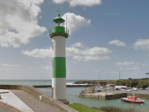
* Doëlan (Douélan) Feu Antérieur
1861. Active; focal plane 20 m (66 ft); white or green light, depending on direction, occulting three times every 12 s. 14 m (46 ft) round cylindrical masonry tower with lantern and gallery. Tower painted white with a single green horizontal band; lantern and gallery painted green. Trabas has a good photo by Capt. Peter, Werning has an excellent photo, a 2022 photo is available, Huelse has a historic postcard view, and Google has a street view (also seen at right) and a satellite view. The height of the lighthouse was increased from 10 m (33 ft) to 14 m (46 ft) in 1934. Located on the east side of the entrance to the harbor of Doëlan. Site open, tower closed. . ARLHS FRA-264; Admiralty D0954; NGA 0520.
* Doëlan (Douélan) Feu Postérieur (Doëlan Amont)
1861. Active; focal plane 27 m (89 ft); quick-flashing red light. 14 m (46 ft) round cylindrical masonry tower with lantern and gallery. Tower painted white with a single red horizontal band; lantern and gallery painted red. Werning has a good photo, Trabas has Capt. Peter's closeup, Steve Allanic has a 2021 closeup, Huelse has a historic postcard view, and Google has a satellite view and a street view from across the estuary. The height of the lighthouse was increased from 10 m (33 ft) to 14 m (46 ft) in 1934. Located on the west side of the harbor of Doëlan, about 325 m (0.2 mi) north northeast of the front light. Site open, tower closed. . ARLHS FRA-265; Admiralty D0954.1; NGA 0524.
* Merrien
1926. Active; focal plane 26 m (85 ft); quick-flashing red light. 8 m (26 ft) solid square tapered concrete tower with gallery; light mounted on a short mast. Top of the tower painted red, the rest white. Trabas has a closeup photo, Detienne has a photo, and Google has a satellite view. Located on a bluff overlooking the west side of the entrance to the narrow harbor of Merrien about 4 km (2.5 mi) south of Moëlan-sur-Mer. Site open, tower closed. ARLHS FRA-358; Admiralty D0952; NGA 0516.

Feu Antérieur (Range Front) Light, Doëlan, April 2013
Google Maps street view

Névez and Trégunc Lighthouses
* Port Manec'h
1868. Active; focal plane 38 m (125 ft); white, red, or green light, depending on direction, occulting four times every 12 s. 10 m (33 ft) round stone tower with lantern and gallery. Tower painted white, lantern and gallery painted red. Werning's photo is at right, Trabas has a fine closeup by Peter Doll, Mathieu Greverie has a 2022 closeup, Guyomard and Carceller have a photo by Gabriel Pottier, Andreas Ludwig has a closeup, Huelse has a historic postcard view, and Google has a satellite view. According to Fichou this was the first directional light (feu à secteur) installed in France. Located on a bluff overlooking the west side of the entrance to the Aven estuary, off the Rue du Port in Port Manec'h, a village in the commune of Névez. Site open, tower closed. . ARLHS FRA-429; Admiralty D0946; NGA 0508.
* Pointe de Trévignon
1924. Active; focal plane 11 m (36 ft); white, red, or green light, depending on direction, occulting four times in a 3+1 pattern every 12 s. 8 m (26 ft) square concrete tower with gallery; light mounted on a short mast. Top of the tower painted green, the rest white. Werning has a good photo, Trabas has Capt. Peter's photo, Detienne has a photo, Pierre Regnault has a 2022 photo, Huelse has a historic postcard view, and Google has a street view and a satellite view. Located on a prominent point at Trévignon, a small boat harbor in Trégunc. Site open, tower closed. . ARLHS FRA-524; Admiralty D0944; NGA 0500.
Roche du Dragon (Dragon Rock)
Date unknown. Active; focal plane 11 m (36 ft); nine very quick white flashes every 10 s. 11 m (36 ft) square skeletal mast mounted atop a round cylindrical concrete tower. Lighthouse painted yellow with one black horizontal band. Trabas has Capt. Peter's photo and Bing has a distant satellite view. Located about 2.5 km (1.5 mi) northwest of Trévignon. Accessible only by boat. Site open, tower closed. Admiralty D0942; NGA 0498.
Phare de Port Manec'h
Port Manec'h Light, Port Manec'h
photo copyright Malte Werning; used by permission
* Pouldohan
1924. Active; focal plane 6 m (20 ft); green flash every 4 s. 6 m (20 ft) square concrete tower; light mounted on a short mast. Top of the tower painted green, the rest white. Trabas has a closeup photo, Detienne has a photo, a 2022 photo is available, and Google has a street view and a satellite view. Located on a point of land on the north side of the entrance to the Baie de Pouldohan, at the end of the Route de Grignallou in Trégunc. Site open, tower closed. . ARLHS FRA-793; Admiralty D0940; NGA 0496.

Concarneau Lighthouses
Le Cochon
Date unknown. Active; focal plane 5 m (17 ft); three flashes every 12 s, white, red or green depending on direction. 11 m (36 ft) round concrete tower on a round stone pier. Entire structure painted green. Trabas has Capt. Peter's photo and Google has a satellite view and a very distant street view. Located in the entrance to Concarneau, about 500 m (0.3 mi) off Le Cabellou. Accessible only by boat. Site open, tower closed. ARLHS FRA-583; Admiralty D0936; NGA 0468.
* Lanriec (1)
1858. Inactive. 8 m (26 ft) 1-1/2 story round stone keeper's house; the light was displayed through the upper half of a second-floor window at the gable end of the house; a green panel covers the lower half of the window as a daymark, and the name Lanriec is written on the end of the house in large green letters. House painted white. Trabas has Capt. Peter's closeup photo, Guyomard and Carceller have photos by Philippe Gourdelier, Detienne has a photo, and Google has a satellite view. The active light (focal plane 13 m (43 ft); quick-flashing green light) has been moved to a post beside the building. Note: the red beacon in Gourdelier's photos is an entrance light for the nearby yacht harbor (D0933, NGA 0488). Located on the Rue des Galets, just off the Rue des Pins, on the east side of the Concarneau harbor entrance in Lanriec. Site open, tower closed. ARLHS FRA-581. Active light: Admiralty D0932; NGA 0492.
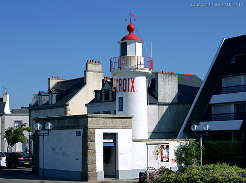
* La Croix (feu antérieur)
1848. Active; focal plane 14 m (46 ft); white light occulting three times every 12 s. 12 m (39 ft) round cylindrical stone tower with lantern and gallery, rising from a small enclosure with a 1-story equipment room. Tower painted white; lantern roof and gallery railing painted red. Werning's photo is at right, Trabas has a closeup, Guyomard and Carceller have photos by Alain Guichaoua, Detienne has a photo, Huelse has a historic postcard view, and Google has a street view and a satellite view. A 2010 photo shows this light and the church spire of Beuzec-Conq, which carries the rear light. The lighthouse is named for its location, the Place de la Croix. (Note: There is another Feu de la Croix near Trieux in Côtes d'Armor.) Located on the Concarneau waterfront, about 300 m (330 yd) west of the entrance to the harbor of Concarneau from the Baie de la Forêt. Site open, tower closed. . Admiralty D0928; NGA 0472.
Feu de la Croix
La Croix Light, Concarneau
photo copyright Malte Werning; used by permission
* Kériolet (Beuzec) (La Croix feu postérieur) (1)
1848. Inactive since 1964. 9 m (30 ft) round cylindrical masonry tower with lantern and gallery; the light was shown through a square window in the front of the masonry lantern. Lighthouse painted white; lantern roof and gallery rail are black. 1-1/2 story keeper's house appears to be a private residence. Werning has an excellent closeup, Detienne has a photo, Guyomard and Carceller have a photo by Alain Guichaoua, and Google has a satellite view and a 2021 street view. This was the original rear light of the La Croix range; it stands 1875 m (1.16 mi) northeast of the Feu de la Croix. It had to be deactivated because increasing development of Concarneau was obscuring the light. The lighthouse is on the original grounds of the Château de Kériolet, a late 19th century mansion. Located on the Rue de Stang-ar-Lin, the road connecting Concarneau and Beuzec-Conq. Site and tower closed (private property) but the lighthouse stands beside a public road. Owner/site manager: private. ARLHS FRA-792.
* Beuzec (La Croix feu postérieur) (2)
1964. Active; focal plane 87 m (285 ft); quick-flashing white light, intensified on the range line. Light mounted on the very highest floor of a 32 m (105 ft) square steeple of the parish church in Beuzec-Conq. Trabas has Capt. Peter's closeup of the steeple showing the light, Guyomard and Carceller have a photo by Alain Guichaoua, and Google has a street view and a satellite view. Located atop a hill in the center of Beuzec-Conq, about 2.5 km (1.5 mi) northeast of the Feu de la Croix in Concarneau. Site open, tower status unknown. ARLHS FRA-197; Admiralty D0930; NGA 0476.

Archipel des Glénan Lighthouses
The Glénan Islands are a group of seven islands and many islets located southwest of Concarneau and southeast of Bénodet. The islands are part of the commune of Fouesnant.

Île Penfret
1837. Active; focal plane 36 m (118 ft); red flash every 5 s. 24 m (79 ft) square masonry tower with lantern and gallery, rising from a 1-story keeper's house. Tower painted white, lantern red. Serge Caredda's photo is at the top of this page, Nicolas Gentil has a photo, French Wikipédia has a page for the lighthouse, Detienne has a good page, Trabas has Capt. Peter's photo, Marinas.com has aerial photos, Huelse has a historic postcard view, Barbara Häner has a street view, and Google has a satellite view. Since 2012 the preservation group Plein Phare sur Penfret has worked to restore and maintain the lighthouse. Located on an island, largest island of the group known as the Archipel des Glénan, about 18 km (11 mi) south southwest of Concarneau and 11 km (7 mi) southwest of Trévignon. Accessible only by boat. Site and tower closed. Site manager: Plein Phare sur Penfret . ARLHS FRA-047; FR-0741; Admiralty D0922; NGA 0444.
Le Huic
1936. Inactive since 1954. 11.5 m (38 ft) square stone tower topped by short round tower. A good photo is available and Google has a satellite view. Located on a rock at the northern corner of the Archipel des Glénan. Accessible only by boat. Site and tower closed.
Île-aux-Moutons
1879. Active; focal plane 18 m (59 ft); white, red, or green light depending on direction, occulting twice every 6 s. 17 m (56 ft) square cylindrical stone tower with lantern and gallery, attached to the front of a 2-story stone keeper's house. Building painted white with unpainted stone trim; lantern and gallery painted black. A DIRM photo is at right, Detienne has a good page for the lighthouse, P.E. Dromard has a good photo, Wikimedia has Julien Carnot's photo, Trabas has Capt. Peter's view, Louis Drapier has a drone view, Marinas.com has aerial photos, and Google has a satellite view. Located on a small island about 11 km (7 mi) southeast of Bénodet and a similar distance southwest of Concarneau. Accessible only by boat and access is forbidden during the bird nesting season. Site and tower closed. . ARLHS FRA-043; FR-0738; Admiralty D0918; NGA 0436.

Île-aux-Moutons Light, Archipel des Glénan
DIRM photo

Bénodet and Combrit Lighthouses
* Pointe du Coq (feu antérieur) (3)
1947 (station established 1848). Active; focal plane 11 m (36 ft); green light, occulting three times every 12 s in a 2+1 pattern, synchronized with the rear light, and intensified on the range line. 13 m (42 ft) round cylindrical stone tower with gallery and a small modern lantern. Seaward side of the tower painted white with a green vertical stripe; lantern is white. Trabas has Capt. Peter's closeup, Werning has a photo, Guyomard and Carceller have photos by Philippe Gourdelier and a map of the range, Wikimedia has several photos, a 2022 photo is avilable, and Google has a street view and a satellite view. This lighthouse is a copy of the original, which was destroyed by the Germans in August 1944; a temporary light served until the new tower was built. This is the front light for the entrance range for the Odet estuary and the harbor of Bénodet. Located in Bénodet, on the east side of the entrance to Odet estuary and close to the Fort du Coq (1862). Site open, tower closed. ARLHS FRA-747; Admiralty D0913.9; NGA 0424.
* La Pyramide (Bénodet) (feu postérieur) (2)
1887 (station established 1848). Active; focal plane 48 m (157 ft); white light, occulting three times every 12 s in a 2+1 pattern, synchronized with the front lights. 39 m (128 ft) round stone tower with lantern and gallery. Tower painted white, lantern green; gallery is unpainted stone. A photo by Christophe Debelmas is at the top of this page, Trabas has a fine closeup by Arno Siering, Jürgen Simon has a 2022 photo, Werning has a photo, Wikimedia has Stéphane Déniel's photo, Guyomard and Carceller have photos by Philippe Gourdelier and a map of the range, Marinas.com has aerial photos, Huelse has a historic postcard view, and Google has a street view and a satellite view. The upper helf of the lighthouse was destroyed by German troops in August 1944; a temporary light served until the lighthouse could be rebuilt. This is the common rear light for the Pointe de Combrit approach range and the Pointe du Coq entrance range. Located on the Corniche de l'Estuaire in Bénodet, about 350 m (1/4 mi) northeast of the Pointe du Coq light. Site open, tower closed. . ARLHS FRA-748; Admiralty D0914; NGA 0428.
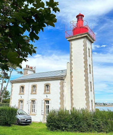
* Pointe de Combrit (feu antérieur) (Phare de Sainte-Marine)
1885. Reactivated (inactive 1944-1952); focal plane 19 m (62 ft); white or red light, depending on direction, occulting four times in a 3+1 pattern every 12 s. 17 m (56 ft) square cylindrical stone tower with gallery and a small modern lantern, attached to a 2-story stone keeper's house. Building painted white with unpainted stone trim; lantern and gallery painted red. A 2022 photo is at right, Trabas has a closeup by Arno Siering, a 2008 closeup and a 2022 photo are available, French Wikipedia has an article with Déniel's photo, Marinas.com has aerial photos, Google has a street view, Huelse has a historic postcard view showing the original lantern, and Google has a satellite view. This is the front light of a due-north range for ships approaches the Anse de Bénodet; the Phare de la Pyramide is the rear light. The lighthouse was heavily damaged by the Germans in August 1944; a temporary light served until the building could be repaired. Located on the coast 250 m (800 ft) north of the Pointe de Combrit, on the southwest side of Sainte-Marine. Site open, tower closed. . ARLHS FRA-245; Admiralty D0914.1; NGA 0420.

Pointe de Combrit Light, Combrit, August 2022
Instagram photo by lavieest1aventure

Loctudy Lighthouses
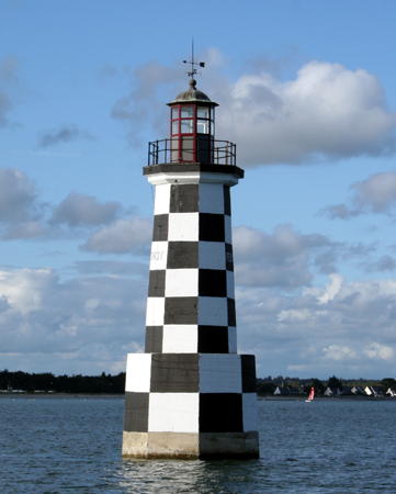
La Perdrix
1918. Inactive since 2002 but maintained by local municipalities as a daybeacon. 18 m (59 ft) octagonal reinforced concrete tower with lantern and gallery mounted on a stone base. Tower painted in a black and white checkerboard pattern; lantern and gallery painted black. Remi Jouan's photo is at right, Jean Marc Cevaër has a closeup photo, Huelse has a historic postcard view, Google has a street view, and Bing has a satellite view. At some point the original lantern was removed and replaced with a modern light; Guyomard and Carceller have older photos showing the light in this condition. The Bureau des Phares et Balises planned to demolish the lighthouse after its deactivation, but the neighboring towns of Île Tudy and Loctudy intervened to take control of the lighthouse and maintain it at their expense as a daybeacon. The towns restored the lighthouse and installed a replica lantern. The lighthouse was repainted in 2022. Note: there is also a Feu des Perdrix at Lézardrieux near Trieux in Côtes-d'Armor. Located on a shoal in the entrance to the Pouldon estuary, between Loctudy and Île Tudy. Accessible only by boat, but easily seen from shore on either side. Site open, tower closed. . ARLHS FRA-389.
* Pointe de Langoz (Loctudy)
1863. Active; focal plane 13 m (42 ft); four flashes every 12 s, white, red, or green depending on direction. 13 m (42 ft) round cylindrical stone tower with gallery and a small modern lantern. Trabas has a good photo by Eckhard Meyer, Guyomard and Carceller have several photos by Philippe Gourdelier, Detienne has a photo, and Google has a street view and a satellite view. Huelse has a historic postcard view showing the lighthouse with its original lantern. This is the entrance light for the Pouldon estuary and the Rivière de l'Abbé. The original lantern was destroyed by the Germans in June 1944. Located on the Pointe de Langoz at the end of Rue du Phare in Loctudy. Site open, tower closed. . ARLHS FRA-330; Admiralty D0906; NGA 0400.

Guilvinec Lighthouses
Lost-Moan
Date unknown. Active; focal plane 8 m (26 ft); three flashes every 12 s, white, red or green depending on direction. 12.5 m (41 ft) round concrete tower with gallery, painted red. Trabas has a photo and Google has a satellite view. Located at the east end of a barely-submerged reef about 800 m (1/2 mi) south of the entrance to Guilvenec. Accessible only by boat. Site open, tower closed. ARLHS FRA-591; Admiralty D0898; NGA 0380.
* Guilvinec Feu Antérieur (1)
1871. Inactive since 1903. 4 m (13 ft) square stone tower; the light was shone through a window. A 2022 closeup photo is available and Google has a street view of both range lights. Located just off the waterfront of Guilvinec, near the intersection of the Rue de la Pointe and the Avenue du Port. Site open, tower closed.

La Perdrix Light, Loctudy, August 2007
Wikimedia Creative Commons photo by Remi Jouan
* Guilvinec Feu Antérieur (2)
1903 (station established 1871). Inactive since 1987. 8 m (26 ft) round cylindrical tower with lantern and gallery. Tower painted white with unpainted stone trim, lantern painted dark green. A photo showing both the 1871 and 1903 lighthouses is available, a 2022 closeup photo is available, Google's street view shows both lighthouses, and Google has a satellite view. Forand has a postcard view from around 1930 showing both towers and a more recent postcard view of the 1903 tower. The present front light is on a post on a small cabinet. Located close to the 1871 tower, near the intersection of the Rue de la Pointe and the Avenue du Port. Site open, tower closed.
* Guilvinec Feu Postérieur
1871. Active; focal plane 26 m (85 ft); quick-flashing white light visible only on or near the range line. Approx. 17 m (56 ft) square cylindrical masonry tower with a broad false front with gabled top and two false chimneys. The false front is painted white with a broad red vertical stripe. Trabas has Capt. Peter's closeup, a 2022 closeup photo is available, and Google has a street view and a satellite view. NGA lists the tower height as 25 m (82 ft), but Fichou's account leads to the more reasonable estimate of 17 m. This rather unusual lighthouse was raised in height by 2.5 m (8 ft) by addition of the lantern-drum in 1903, when the range was realigned. At that time the light was 500 m (0.3 mi) northeast of the 1903 front light; today it is 1000 m (0.6 mi) northeast of the 1987 front light. The range also has a middle light, which sports a drum daymark similar to that of the rear light. Site open, tower closed. ARLHS FRA-564; Admiralty D0896.1; NGA 0368.
* Môle de Guilvinec
1923. Active; focal plane 11 m (36 ft); red flash every 4 s. 10 m (33 ft) round masonry tower with lantern and gallery. Upper half of lighthouse painted red, lower half white. Stéphane Déniel's photo is at right, Trabas has a closeup by Arno Siering, Guyomard and Carceller have good photos, Gérard and Jacqueline Alary have a nice closeup, Detienne has a photo, Huelse has a historic postcard view, and Bing has a satellite view. The harbor opens to the west, with the entrance being a narrow opening between two moles. Located at the end of a spur off the north mole. Accessible by walking the mole. Site open, tower closed. ARLHS FRA-314; Admiralty D0900; NGA 0376.

Môle de Guilvinec Light, Guilvinec, June 2003
Wikimedia Creative Commons photo by Stéphane Déniel

Baie d'Audierne Lighthouses

The Bay of Audierne is the bight between the Pointe de Penmarc'h and the Pointe du Raz. Geographically this embayment is not part of the Bay of Biscay; it is the southernmost coastline of the Celtic Sea, which extends northward to Ireland.

Penmarc'h Lighthouses
* Pointe de Penmarc'h (1) (La Vieille Tour)
1831 (on a much older tower). Inactive since 1835. Approx. 15 m (49 ft) square stone tower with castellated top, now partially in ruins. Daniel Théau has the 2017 photo seen at right, Werning has a fine photo, a drone view is available, and Google has a satellite view. This tower, part of the Chapelle Saint-Pierre, a medieval fortified chapel, is said to have been used to display an open fire during the 15th and 16th centuries. In 1831 a lantern was mounted temporarily atop the tower while the Penmarc'h lighthouse was under construction. Today a French Navy signal station stands next to the old tower and Yann Crapart has a photo that shows the signal tower and all three Penmarc'h lighthouses. Located in Saint-Pierre, on the point of Penmarc'h, about 3 km (1.8 mi) southwest of the town of Penmarc'h. Site open, tower status unknown. ARLHS FRA-790.
** Pointe de Penmarc'h (2)
1835 (station established 1831). Inactive since 1897. 40 m (131 ft) round stone tower, rising from the center of a 2-story stone keeper's house. Lantern removed. The lighthouse is unpainted stone. Daniel Théau has the 2017 photo seen at right, Werning has a photo, the tower is centered in Jean-Pierre le Roy's 2018 photo, Huelse has a historic postcard view, Marinas.com has aerial photos, and Google has a street view and a satellite view. This lighthouse was a twin of the Île de Batz light in Northern Finistère. It continued to house keepers after being deactivated, and in recent years the Penmarc'h fog horn (blast every 60 s) has been mounted atop the tower. The keeper's quarters now houses a maritime museum, the Centre de Découverte Maritime. In 2021 the city and the Fondation du Patrimoine Bretagne launched a campaign to rasie funds for a €1.077 million restoration of the tower. Located in Saint-Pierre, on the point of Penmarc'h, about 3 km (1.8 mi) southwest of the town of Penmarc'h. Site open, museum open daily in July and August and daily except Tuesdays in April, May, June and September, tower closed. Site manager: Centre de Découverte Maritime . ARLHS FRA-270.

Left to right: Signal Station, La Veille Tour and 1835 Penmarc'h Light, Penmarc'h, August 2017
Google Maps photo by Daniel Théau
**** Pointe de Penmarc'h (3) (Grand Phare d'Eckmühl)
1897 (station established 1831). Active; focal plane 60 m (197 ft); white flash every 5 s. 65 m (213 ft) square granite tower with lantern, octagonal granite watch room, and gallery. Tower unpainted, lantern painted white. A photo is at right, Detienne has a page for the lighthouse, Marie-Paule Streiff has a 2022 photo, Werning has a photo, Trabas has a closeup by Capt. Peter, Huelse has a historic postcard view, Marinas.com has aerial photos, and Google has a street view and a satellite view. In the late 1880s it was decided that the light at Penmarc'h should be raised to a focal plane of 60 m, but engineers reported that the 1835 tower was not strong enough to support such an extension. In late 1892 Adélaïde-Louise Davout, Marquise de Blocqueville, passed away and left substantial funds for the new tower in her will, provided the lighthouse was dedicated to the memory of her late husband Napoléon-Louis Davout, Prince d'Eckmühl. The result is one of the most impressive lighthouses ever built on the French mainland, standing at the southwestern corner of Finistère and the northwestern entrance to the Bay of Biscay. Guyomard and Carceller also have the history of the lighthouse. The centennial of the lighthouse was celebrated in 1997. Located on the point of Penmarc'h in Saint-Pierre, about 3 km (1.8 mi) southwest of the town of Penmarc'h. Site open, tower open daily April 1 through Armistice Day (November 11). Site manager: Centre de Découverte Maritime. . ARLHS FRA-256; FR-0716; Admiralty D0890; NGA 0308.
Men-Hir
1899. Active; focal plane 19 m (62 ft); two flashes every 6 s, white or green depending on direction. 17 m (56 ft) round masonry tower; lantern removed. Upper half of the tower painted black, lower half white. Trabas has Capt. Peter's photo, Detienne has a closeup, Guyomard and Carceller have a distant photo by François Péléter, Huelse has a closeup postcard view, and Google has a satellite view. Construction began in 1891 and the tower was nearly complete when a great storm damaged it heavily on 4 December 1896. Located on an exposed rock at the western end of the Penmarc'h reef about 2 km (1.2 mi) west of the Pointe de Penmarc'h. Accessible only by boat. Site and tower closed. ARLHS FRA-353; Admiralty D0892; NGA 0344.
* [Chenal de Groumili feu postérieur]
Date unknown. Active; focal plane 13 m (43 ft); continuous green light. 14 m (46 ft) round cylindrical concrete tower. Lighthouse painted with black and white horizontal bands; there is also a square orange drum-shaped daymark at the top. Trabas has Capt. Peter's photo, Detienne has a photo, and Google has a street view and a satellite view. The front light is on a similar 11 m (36 ft) tower 300 m (330 yd) northwest. Located at the water's edge just off the Rue du Sémaphore about 400 m (1/4 mi) north of the Penmarc'h lighthouses. Site open, tower closed. Admiralty D0886.1; NGA 0316.

Grand Phare d'Eckmühl, Penmarc'h, May 2010
Wikimedia Creative Commons photo by El Funcionario

Plouhinec Lighthouse
* Pors-Poulhan
1927. Active; focal plane 14 m (46 ft); quick-flashing red light. 6 m (20 ft) square concrete tower with gallery but no lantern; light mounted on a short mast. The top of the tower is painted red, the rest white. Trabas has a closeup, a 2022 closeup is avilable, Werning has a photo, Detienne has a photo, Guyomard and Carceller have a photo by J. Evenat, and Google has a street view and a satellite view. Located on the west side of the entrance to the small harbor of Pors-Poulhan, just off the Rue de l'Océan, about 4 km (2.4 mi) southeast of Plouhinec. Site open, tower closed. ARLHS FRA-746; Admiralty D0884; NGA 0304.

Audierne Lighthouses
* Raoulic (feu antérieur)
1856. Active; focal plane 11 m (36 ft); three flashes every 12 s, white or green depending on direction. 11 m (36 ft) round cylindrical masonry tower with gallery, painted white with a red top. Lantern removed and replaced by a modern light on a short mast. Werning has a photo, Trabas has Capt. Peter's photo, Detienne has a photo, Didier Pinchon has a 2023 photo, Guyomard and Carceller have a photo by J. Evenat, Florent Moritz has a good closeup, Huelse has a historic postcard view showing the original lantern, and Google has a street view and a satellite view. This was formerly the front light of a range with the Feu de Trescadec (next entry) as the rear light; after 1887 it served as the front light for a range (now discontinued) that had the Feu de Kergadec as the rear light. Located at the end of the Môle de Raoulic, on the west side of the entrance to the harbor of Audierne. Accessible by walking the pier. Site open, tower closed. . ARLHS FRA-447; Admiralty D0877; NGA 0296.
* Trescadec (feu antérieur)
1856 (relocated here in 1887). Inactive since 1972. 10 m (33 ft) round cylindrical masonry tower with lantern and gallery, painted white; lantern and gallery painted red. Werning's photo is at right, Detienne has a photo, Andreas Köhler has a photo, Guyomard and Carceller have a photo by Dominique Resmon, Huelse has a historic postcard view, and Google has a good street view and a satellite view. This lighthouse was originally located in the garden of the Capucin monastery in Audierne as the rear light of the Raoulic range. In 1887 the range was realigned; a new rear lighthouse was built at Kergadec and this lighthouse was relocated to the waterfront to serve as a second front light (on a different range line) for Kergadec. The lighthouse was deactivated in 1972 when the rear light was converted to a directional light. Located on the Boulevard Manu Brusq, the coastal road west of the Audierne harbor entrance. Site open, tower closed. . ARLHS FRA-789.
* Kergadec (feu postérieur) (3)
1950 (station established 1887). Active; focal plane 44 m (144 ft); continuous red light, intensified on the range line; also a quick-flashing light, white, red, or green depending on direction. 15 m (49 ft) octagonal concrete tower with gallery but no lantern. Upper quarter of the tower painted red, the rest white. Werning has a good photo, Trabas has a closeup by Arno Siering, Detienne has a photo, a 2022 photo is available, and Google has a satellite view and a closeup street view. The second (1902) lighthouse was destroyed by German troops in 1944. Located on a hill on the southwest side of Audierne. Site open, tower closed. ARLHS FRA-325; Admiralty D0877.1; NGA 0288.
Feu de Trescadec
Trescadec Light, Audierne
photo copyright Malte Werning; used by permission

Esquibien Lighthouse
* Pointe de Lervily
1955. Active; focal plane 20 m (66 ft); three flashes every 12 s, white or red depending on direction. 12 m (39 ft) round cylindrical masonry tower, painted white, topped by a small red lantern. Modern 1-story keeper's house. This is an old signal tower (sémaphore) to which a modern light was added. Werning has a nice photo, Trabas has Capt. Peter's closeup, Detienne has a photo, Jean-Paul Chapalain also has a closeup, and Google has a satellite view and a street view from the rear. Located at the end of the Rue du Sémaphore on a headland projecting into the Baie d'Audierne, about 3 km (1.8 mi) south of Esquibien. Site open, tower closed. ARLHS FRA-336; Admiralty D0874; NGA 0300.

Notable faux lighthouses:

Adjoining pages: North: Western Finistère | South: Morbihan

Return to the Lighthouse Directory index | Ratings key

Posted August 29, 2005. Checked and revised September 16, 2023. Lighthouses: 34. Site copyright 2023 Russ Rowlett and the University of North Carolina at Chapel Hill.