Lighthouses of Eastern Italy

Most of Italy (officially the Italian Republic, Repubblica Italiana in Italian) occupies a long peninsula in the Mediterranean Sea, with the Adriatic and Ionian Seas on the east and the Ligurian and Tyrrhenian Seas to the west; the country also includes the Mediterranean's two largest islands, Sicily and Sardinia, and many smaller islands. With this geography Italy has a very long coastline reckoned by geographers at about 7600 km (4722 mi). Guarding this coast are many lighthouses; the Directory lists more than 400.

Italy is divided into 20 regions (regioni), many of them well known outside the country in their own right. This page includes the lighthouses of the four regions of Emilia-Romagna, Marche, Abruzzo, and Molise, which face the Adriatic Sea on the east coast of the country. This area includes the important ports of Goro and Ancona as well as many smaller ports.

Prior to the unification of Italy in 1860-61 Emilia-Romagna and Marche were generally ruled by the pope as part of the Papal States. Abruzzo and Molise were generally part of the Kingdom of Naples until the end of the Napoleonic Wars (1803-1815) when the Kingdom of Naples merged with Sicily to form the Kingdom of the Two Sicilies.

The Italian word for a lighthouse is faro, plural fari. This name is usually reserved for the larger coastal lights; smaller beacons are called fanali. In Italian isola is an island, isolotto is an islet, secca is a shoal, cabo is a cape, punta is a point of land, baia is a bay, stretto is a strait, fiume is a river, and porto is a harbor.

Aids to navigation in Italy are operated and maintained by the Italian Navy's Servizio dei Fari e del Segnalamento Marittimo (Lighthouse and Maritime Signal Service). Lighthouse properties are naval reservations, generally fenced and closed to the public.

ARLHS numbers are from the ARLHS World List of Lights. EF numbers are from the Italian Navy's light list, Elenco Fari. Admiralty numbers are from volume E of the Admiralty List of Lights & Fog Signals. U.S. NGA List numbers are from Publication 113.

General Sources
Fari e Segnalamenti
Lighthouse information from the Italian Navy's Servizio dei Fari.
Online List of Lights - Italy
Photos by various photographers posted by Alexander Trabas. Most of the photos from this area are by Capt. Peter Mosselberger (Capt. Peter)or by Eckhard Meyer.
Cyberlights Lighthouses - Italy
Photos of Italian lighthouses by Egidio Ferrighi, posted by Gary Richardson and Anna Klein.
Lighthouses in Italy
Aerial photos posted by Marinas.com.
Wikimedia: Lighthouses in Italy
Photos by various photographers available in Wikimedia Commons.
World of Lighthouses - Italy
Photos by various photographers available from Lightphotos.net.
Italienische Leuchttürme auf Historischen Postkarten
Historic postcard images posted by Klaus Huelse.
GPSNavigationCharts
Navigation chart information for Italy.
Navionics Charts
Navigation chart information for Italy.


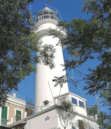
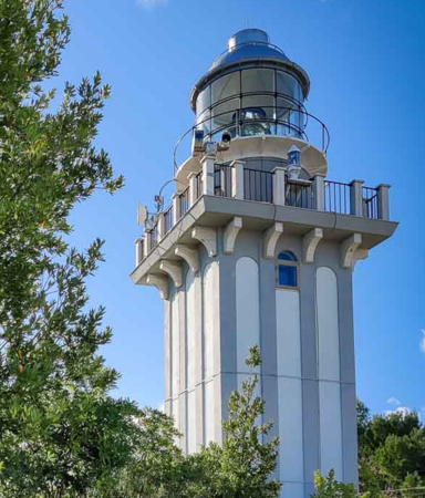
Colle Cappucini Light, Ancona, April 2017
Google Maps photo by Serena Nobile

Lighthouses of Emilia-Romagna

Historically, Ferrara Province is in Emilia, while Ravenna, Forli-Cesena, and Romini Provinces are in Romagna.

Ferrara Province Lighthouses
** Goro (Porto di Po di Goro, Gorino) (2)
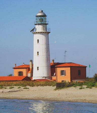
1950 (station established 1862). Active; focal plane 22 m (72 ft); two white flashes every 10 s. 24 m (79 ft) round tower with lantern and gallery, attached to a 2-story brick keeper's house. Tower painted white; house is unpainted red brick; lantern dome is gray metallic. A 2021 photo is at right, Marco Boni has a 2021 photo, a 2021 drone view is available, Mitico Silvio has a 2018 photo, another excellent photo is available, Trabas has Capt. Peter's photo, and Google has a street view and a satellite view. This historic lighthouse marks the entrance to the Po River. The lighthouse is on the south side of the Po Delta in a area of dunes and marshes. Ruins of the older lighthouse, destroyed during World War II, can be found several hundred meters west of the present lighthouse. The present lighthouse was painted with red and white horizontal bands until 1985; Huelse has a postcard view showing this daymark. The town and province cooperated to restore the lighthouse in 1987. By 2015 the lighthouse was reported in poor condition. In 2016 the Navy leased the light station for tourist development, and in the spring of 2021 it opened as a boutique hotel and restaurant. Located on the south side of the river's southernmost entrance, which forms part of the boundary between Emilia-Romagna and Veneto. Accessible only by boat; visitors report that the former trail through the marsh is no longer passable. There is a distant view from across the channel at the end of highway SP66. Site, hotel and restaurant open, tower closed. Site manager: Il Faro di Goro . ARLHS ITA-073; EF-4072; Admiralty E2434; NGA 11428.
* Porto Garibaldi (2)
Around 1950 (station established 1891). Active; focal plane 14 m (46 ft); four white flashes every 15 s. 12 m (39 ft) round cylindrical concrete tower, rising from the front of a 2-story keeper's house. Entire lighthouse painted white; lantern dome is gray metallic. Trabas has an excellent photo, Roberto Moretti has a 2021 photo, Giuseppe Montana has a 2017 photo, Marinas.com has distant aerial photos, Huelse has a historic postcard view, and Google has a street view and a satellite view. This is the westernmost lighthouse of the Adriatic Sea. The original light was on a mast. Porto Garibaldi, the seaport of the city of Comacchio, was almost completely destroyed during World War II; the original lighthouse was among the casualties. Located on the north side of the harbor entrance at Porto Garibaldi, about 30 km (20 mi) north of Ravenna. Site open, tower closed. ARLHS ITA-116; EF-4062; Admiralty E2426; NGA 11400.

Goro Light, Porto di Po, 2021
photo posted by Il Faro di Goro

Ravenna Province Lighthouses
The provincial capital of Ravenna has a population of about 160,000. The city is inland but is connected to the sea by the 11 km (7 mi) long Canal Corsini (Candiano Canal). The harbor facilities are along the canal.
* Ravenna North Breakwater
Date unknown. Active; focal plane 10 m (33 ft); two green flashes every 6 s. 8 m (26 ft) bottle-style post light mounted a robust conical concrete base. Entire lighthouse painted green. Trabas has Capt. Peter's photo, Łukasz Szajner has a 2018 photo, Luca Zacchi has a street view, and Google has a satellite view. Located at the end of the 2.5 km (1.5 mi) long north breakwater of Ravenna. Accessible by walking the pier. Site open, tower closed. EF-4058; Admiralty E2420; NGA 11388.
* Baiona (Leading Light)
Date unknown. Active (privately maintained); focal plane 12 m (39 ft); continuous light, white, red or green depending on direction. 12 m (39 ft) square cylindrical skeletal tower. Trabas has Capt. Peter's photo and Google has a street view and a satellite view. The light guides vessels entering the Canal Corsini. Located on the Via Baiona about 1 km (0.6 mi) west of the waterfront. Site open, tower closed. Owner/operator: Port of Ravenna. Admiralty E2417.9; NGA 11375.
* Marina di Ravenna (Porto Corsini)
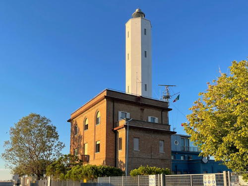
1862 (Achille Buffoni) (rebuilt in 1950). Active; focal plane 35 m (115 ft); white flash every 5 s. 33 m (108 ft) octagonal cylindrical tower with lantern and gallery, rising from a 3-story brick building that includes the port captain's office. Tower painted white; building is unpainted red brick; lantern dome is gray metallic. A photo by Berti Mannes is at right, Trabas has Capt. Peter's photo, Luca Zacchi has a closeup photo, another photo is available, and Google has a street view and a satellite view. This lighthouse marks an artificial channel cut in the 18th century for the city of Ravenna; the channel connects to a harbor, the Marina di Ravenna, dredged from the lagoon and wetlands behind the barrier island. The original light was 24 m (79 ft) tall; it was raised in 1935 and rebuilt after being heavily damaged during World War II. Ravenna was also the site of a Roman lighthouse. Located on the south side of the harbor entrance, about 10 km (6 mi) northeast of Ravenna. Site open, tower closed. . ARLHS ITA-114; EF-4056; Admiralty E2418; NGA 11376.

Marina di Ravenna Light, Ravenna, August 2022
Instagram photo by Berti Mannes
* Ravenna South Breakwater
Date unknown. Active; focal plane 10 m (33 ft); two red flashes every 6 s. 8 m (26 ft) bottle-sty;e post light mounted a robust conical concrete base. Entire lighthouse painted red. Trabas has Capt. Peter's photo, a 2022 photo is available, and Google has a street view and a satellite view. Located at the end of the 2.5 km (1.5 mi) long north breakwater of Ravenna. Accessible by walking the pier. Site open, tower closed. EF-4057; Admiralty E2419; NGA 11384.
* Cervia (3)
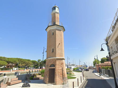
1875 (extended in 1918). Active (privately maintained); focal plane 16 m (52 ft); white light, 1 s on, 1 s off. 16 m (52 ft) 2-stage octagonal brick tower with lantern and a gallery at the top of the first stage. The lighthouse is unpainted red brick. A photo is at right, Marco Succi Vacanze has a 2021 photo, Trabas has Capt. Peter's photo, a 2008 photo is available, Francesco Guarlotti has a 2023 photo, and Google has a street view and a satellite view. The upper stage of the tower was added in 1918. This lighthouse has very little navigational value today, but it is maintained as a historic monument. Cervia is a resort town of about 30,000 residents 25 km (15 mi) south of Ravenna. Located on the south side of the harbor about 1.6 km (1 mi) from the entrance. Site open, tower closed. Owner/site manager: Commune di Cervia. . ARLHS ITA-196; Admiralty E2411; NGA 11352.
** Cervia (1) (Torre San Michele)
1691. Inactive since 1756. 22 m (72 ft) square stone tower. Lukáš Maxmilián Stružka has a 2021 photo and Google has a street view and a satellite view. Completed in 1691, this historic tower was built as a fortress; it was then near the shore, which has extended by alluvial deposition over the centuries. As this process continued the light was moved to a new tower in 1756. The building now includes a tourist information center for Cervia. Located on the south side of the Canale di Cervia about 800 m (1/2 mi) southwest of the present lighthouse. Site and building open.

Cervia Light, Cervia, September 2007
Wikimedia Creative Commons photo by Swiss79

Forli-Cesena Province Lighthouses
* Cesenatico (2)
Date unknown (station established 1892). Active; focal plane 18 m (59 ft); two white flashes every 6 s. 17 m (56 ft) round cylindrical brick tower attached to a 2-story brick keeper's house. Tower painted white; house painted yellow with white trim; lantern dome is gray metallic. A 2021 photo shows the lighthouse freshly repainted, Trabas has Meyer's photo, Mauro Gardella has a 2008 sunset photo, Huelse has a historic postcard view, Marinas.com has aerial photos, and Google has a street view and a satellite view. The keeper's house continues in service as an office of the Guardia Costiera. The original light was an 18 m (59 ft) square tower; it was destroyed during World War II. The light guides ships entering the historic Porto Canale, a waterway first envisioned in drawings by Leonardo da Vinci. Located on the east side of the harbor channel in Cesenatico, a port town of about 26,000 residents associated with the inland city of Cesena. Site open, tower closed. . ARLHS ITA-052; EF-4028; Admiralty E2404; NGA 11340.
* [Rocca delle Caminate]
1927(?). Inactive since World War II. Square cylindrical stone watchtower with gallery. Roberto Valente has a 2019 photo, Simone Cortesi has a second 2019 photo, and Google has a satellite view. The Rocca della Caminate is an 11th century castle that was largely destroyed by an earthquake in 1870. Rebuilt in the 1920s, it served as a summer residence for Mussolini. When he was in residence a powerful light was displayed, said to have been visible for more than 60 km (about 40 mi) from a focal plane of 330 m (1083 ft). However, this light was useless for navigation. Located on a high ridge about 20 km (13 mi) west southwest of Cesena, near Predappio, about 28 km (17.5 mi) from the coast. Site open; the castle is open for tours.

Rimini Province Lighthouse
*
Rimini (3)
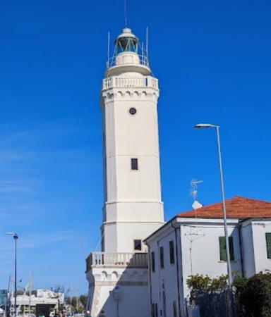
Late 1940s (station established 1733). Active; focal plane 27 m (89 ft); three white flashes every 12 s. 25 m (82 ft) square cylindrical brick tower with lantern and gallery, rising from a large square base in front of a 2-story brick keeper's house. Entire lighthouse painted white; lantern dome is gray metallic. Oleh Kushch's photo is at right, Trabas has Capt. Peter's closeup photo, Eni Budo has a 2021 photo, Maria Grazia Marrulli has a 2008 closeup photo, another good photo is available, and Google has a street view and a satellite view. The short 1862 lighthouse was extended by 9 m (30 ft) in 1911, giving it the appearance seen in a postcard view posted by Huelse. Heavily damaged during World War II, it was torn down after the war and replaced by the present tower, a taller version of the original. The provincial capital of Rimini, a popular resort destination, has a population of about 150,000. Located on the Via Destra del Porto on the east side of the harbor channel in Rimini. Site open, tower closed. . ARLHS ITA-152; EF-4005; Admiralty E2394; NGA 11324.

Rimini Light, Rimini, August 2018
Wikimedia Creative Commons photo by Oleh Kushch

Lighthouses of Marche

Pesaro e Urbino Province Lighthouses
* Cattolica (Gabicce) (3?)
1960 (station established 1882). Active; focal plane 17 m (56 ft); three long (2 s) white flashes every 14 s. 17 m (56 ft) square skeletal tower with lantern and gallery, painted with black and white horizontal bands, rising from an octagonal 1-story brick equipment building. Andreas Köhler has a 2021 photo, a 2009 photo and a 2018 closeup are available, Trabas has a photo by Capt. Peter, and Google has a street view and a satellite view. The channel in front of this lighthouse forms part of the boundary between the Marche and Emilia-Romagna. An earlier light was in a small wooden tower shown in Huelse's postcard view. Located at the root of the east mole in Gabicce Mare, the town in Marche that adjoins Cattolica in Emilia-Romagna. Accessible by walking the mole. Site open, tower closed. ARLHS ITA-051; EF-3996; Admiralty E2381; NGA 11308.
* Monte San Bartolo (Pesaro)
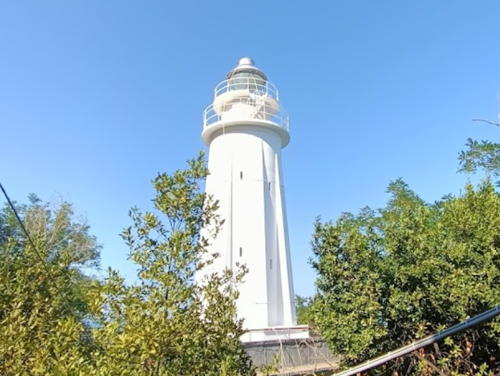
1952 (station established 1883). Active; focal plane 175 m (574 ft); two white flashes every 15 s. 25 m (82 ft) round tower mounted on a square 1-story base, attached to a 2-story keeper's house. Tower painted white. This is a powerful lighthouse with a range of 40 km (25 mi). A 2020 photo is at right, Ferrighi has a photo, Trabas has Meyer's photo, Donatella Paolozzi has a closeup photo, Mirko Pucci has a distant view, Stefano Terenzi has a great aerial view, and Google has a satellite view. Huelse has a postcard view of the 1883 Pesaro lighthouse, known as the Old Port East Entrance Light; it was destroyed in 1944, during World War II. However, Michel Forand has pointed out that the present lighthouse really replaced the lost Castel di Mezzo lighthouse, which was located about 8 km (5 mi) farther northwest. Located on the Strada dei Cipressi on a steep slope above the Adriatic about 2 km (1.2 mi) northwest of Pesaro. Site open, tower closed. . ARLHS ITA-106; EF-3986; Admiralty E2372; NGA 11296.
* Fano (2?)
Around 1950 (station established before 1862). Active; focal plane 21 m (69 ft); white flash every 5 s. 20 m (66 ft) square cylindrical brick tower with lantern and gallery, rising from a 2-story brick port captain and Guardia Costiera (coast guard) headquarters building. Tower painted white; lantern is gray metallic; coast guard building is unpainted red brick. Trabas has a photo, Nicolò Canestrari has a 2008 photo, Ferrighi has a photo, and Google has a street view and a satellite view. Huelse has a postcard view of the original lighthouse, a 16 m (52 ft) square cylindrical tower attached to a small 1-story building. Located one block south of the waterfront in Fano. Site open, tower closed. . ARLHS ITA-065; EF-3966; Admiralty E2362; NGA 11280.

San Bartolo Light, Pesaro, July 2020
Instagram photo by rerenato60

Ancona Province Lighthouses
The regional and provincial capital of Ancona is the most important port of the central Adriatic coast; it includes terminals for fast ferries crossing to ports in Croatia, Albania, and northern Greece. The city has a population of about 100,000.
* Senigallia (Molo di Levante) (3?)
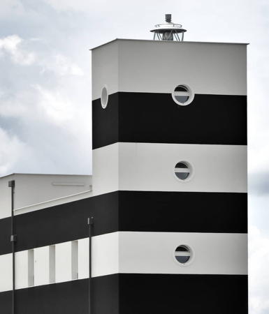
1950 (station established 1847). Active; focal plane 17 m (56 ft); two long (2 s) white flashes every 15 s. 17 m (56 ft) rectangular cylindrical tower with lantern, rising from the seaward end of a 3-story building. The entire building is painted with black and white horizontal bands; the lantern is gray metallic. Francesco Gasparetti's photo is at right, Trabas has a good photo by Capt. Peter, Gasparetti has another photo, Ferrighi also has a photo, Emanuele Bonsignore has a closeup street view, and Google has a satellite view and a distant street view. This building incorporates the 18th century building seen at the right in Huelse's pre-1915 postcard view of what is believed to be the second lighthouse. Located near the root of the east breakwater (Molo di Levante) at Senigallia. Accessible by a street, the Banchina di Levante, along the mole. Site open, tower closed. . ARLHS ITA-181; EF-3954; Admiralty E2358; NGA 11276.
Marina Dorica
Date unknown. Inactive (a decorative light may be displayed). Approx. 6 m (20 ft) tower with lantern and gallery built on the roof of large marina pier building. The tower appears to be unpainted brick; lantern painted white with a black dome. Raffaella Abbate has a street view and Google has a satellite view. Located on the main quay of the marina, at the south end of Ancona harbor. Site open, tower closed. Owner/site manager: Marina Dorica.
Ancona Molo Foraneo Sud (2)
Date unknown (station established 1868). Active; focal plane 11 m (36 ft); green flash every 4 s. 7 m (23 ft) round stone tower with lantern and gallery, painted green. Trabas has Capt. Peter's photo, Luca Gobbi has a closeup photo, and Google has a satellite view. Located at the end of the south breakwater of Ancona. Site and tower closed. EF-3932; Admiralty E2349; NGA 11220.
* Ancona Molo Foraneo Nord (2)
Date unknown (station established 1868). Active; focal plane 11 m (36 ft); red flash every 4 s. 6 m (20 ft) round stone tower with lantern and gallery, painted red. Trabas has a closeup photo, Giovanni Figuretti has a 2021 photo, Wolfgang Gottschalk has a 2007 photo, Lor Manzoli has a street view, and Google has a satellite view. Located at the end of the north breakwater of Ancona. Accessible by walking the pier. Site open, tower closed. EF-3931; Admiralty E2346; NGA 11224.

Senigallia Light, Senigallia, March 2006
Flickr Creative Commons photo by Francesco Gasparetti
** Colle Cappucini (Ancona) (1)
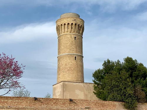
1860. Inactive since 1965. Approx. 20 m (66 ft) round cylindrical masonry tower with a flared masonry gallery, rising from a 2-story keeper's house. Lantern removed. The lighthouse is unpainted. A photo is at right, Marco Baldinelli has a page for the lighthouse, Wikimedia has an excellent photo, Huelse has a historic postcard view, Simone Lugaresi has a 2017 street view, and Google has a satellite view. Ordered by Pope Pius IX, this fortified light station was one of the last public works built in Marche by the papal administration. In 2000 a volunteer group secured permission to clean up the tower and open the building on weekends. Located on the Via del Faro at the edge of the Parco Monte Cardeto, overlooking the harbor. Site open; tower open Saturday afternoons and Sundays all year. .
* Colle Cappucini (Ancona) (2)
1965 (station established 1860). Active; focal plane 118 m (387 ft); four white flashes every 30 s. 15 m (49 ft) square cylindrical concrete tower with lantern and gallery. A 1st order Fresnel lens is in use. Tower colored with gray and white vertical stripes; these colors may be in the concrete rather than painted. Lantern dome is gray metallic. Serena Nobile's photo is at the top of this page, Ferrighi has a photo, Trabas has a similar photo, Wikimedia has Giorgio Montesi's closeup, Simone Lugaresi has a 2017 street view, and Google has a satellite view. Located just north of the historic lighthouse. Site open, tower closed. . ARLHS ITA-104; EF-3930; Admiralty E2344; NGA 11216.

Macerata Province Lighthouses
* Civitanova Molo Nord
Date unknown. Active; focal plane 9 m (30 ft); green flash every 5 s. 8 m (26 ft) round tower with lantern and gallery, painted green. Trabas has a good photo by Meyer, a nighttime photo shows the lighthouse in silhouette, Marco Macelloni has a closeup street view, and Google has a satellite view. Civitanova Marche -- the "New City of Marche" -- is a resort town and yachting center about 30 km (19 mi) southeast of Ancona. Located at the end of the mole on the north side of the harbor of Civitanova Marche; accessible by walking the mole. Site open, tower closed. EF-3914; Admiralty E2339; NGA 11196.

1860 Colle Cappucini Light, Ancona, April 2013
Wikimedia Creative Commons photo by Rick
* Civitanova Marche (Chiesa del Christo Re)
Date unknown (tower built in the 1980s). Active; focal plane 42 (138 m); four long (1.5 s) white flashes every 20 s. 46 m (151 ft) round cylindrical church bell tower with a tall, conical steeple. The light is mounted on the balcony at the top of the tower. Trabas has Capt. Peter's closeup photo, Ewindaro Dectis has a good 2017 photo, and Google has a street view and a satellite view. The bell tower was designed by architect Dante Tssotti. Located just off the waterfront of Civitanova Marche. Site open, tower status unknown. EF-3912; Admiralty E2337.6; NGA 11208.

Fermo Province Lighthouse
*
Pedaso (2)
1950 (station established 1877). Active; focal plane 51 m (167 ft); three white flashes every 15 s. 21 m (69 ft) round concrete tower with eight buttresses, lantern, and gallery, rising from a 2-story masonry keeper's house. The lighthouse is white concrete; lantern dome is gray metalic. Trabas has a good photo by Meyer, Massimo Ceci has a 2023 photo, Marco Fagioli has a 2019 drone view, Domenico Caselli has additional photos, and Google has a street view and a satellite view. Huelse has a historic postcard view of the original lighthouse, which was similar in size and form but not in detail. The old tower was pulled down after being heavily damaged by German troops in World War II. Located on a bluff about 1.5 km (1 mi) south of Pedaso. Site open, tower closed. . ARLHS ITA-112; EF-3904; Admiralty E2336; NGA 11188.

Ascoli Piceno Province Lighthouse
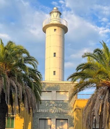
* San Benedetto del Tronto
1957. Active; focal plane 31 m (102 ft); two white flashes every 10 s. 31 m (102 ft) round cylindrical concrete tower with lantern and gallery, rising from the center of a 2-story building attached to a coast guard headquarters. The lighthouse is white concrete; lantern dome is gray metalic. Stefano Travaglini has the 2017 photo seen at right, Trabas has Capt. Peter's closeup photo, Wikimedia has Peter Foster's photo, Andrea Simonetti has a 2022 photo, and Google has a street view and a satellite view. Located on the Viale T. Pasqualini on the waterfront of San Benedetto del Tronto, an important seaport with a population of about 100,000. Site open, tower closed. . ARLHS ITA-154; EF-3898; Admiralty E2332; NGA 11176.

San Benedetto del Tronto Light, March 2017
Google Maps photo by Stefano Travaglini

Lighthouses of Abruzzo

Teramo Province Lighthouses
* Giulianova Molo Nord (2)
Date unknown. Active (privately maintained); focal plane 8 m (26 ft); green flash every 5 s. 7 m (23 ft) post mounted on a round base. Entire lighthouse is green. Andreas Köhler has a photo. Trabas has Köhler's photo, Marinas.com has aerial photos, and Google has a satellite view. Located at the end of the north breakwater of Giulianova, the only port of any size in Teramo. Accessible by walking the pier. Site open, tower closed. Admiralty E2326; NGA 11164.
* Giulianova Molo Sud (2)
Date unknown. Active (privately maintained); focal plane 8 m (26 ft); red flash every 5 s. 7 m (23 ft) post mounted on a round base. Entire lighthouse is red. Andreas Köhler has a photo. Trabas has Köhler's photo, Pasquale Giovine has a 2009 closeup, Marinas.com has aerial photos, and Google has a satellite view and a 2018 street view of the earlier tower. Located at the end of the north breakwater of Giulianova. Accessible by walking the pier. Site open, tower closed. Admiralty E2324; NGA 11156.

Pescara Province Lighthouses
* Pescara Molo Nord (Molo di Maestro)
Date unknown. Active; focal plane 13 m (43 ft); green flash every 4 s. 11 m (36 ft) round "bottle" style light mounted on a round 1-story equipment shelter. Entire lighthouse is green. Trabas has Meyer's photo, a 2012 closeup is available, Johnny D'Aloisio has a closeup street view, and Google has a satellite view. Located at the end of the north breakwater of Pescara. Accessible by walking the pier. Site open and a stairway leads to the top of the equipment shelter. EF-3880; Admiralty E2320; NGA 11152.
* Pescara Molo Sud (Molo di Scirocco)
Date unknown. Active; focal plane 13 m (43 ft); red flash every 4 s. 11 m (36 ft) round "bottle" style light mounted on a round 1-story equipment shelter. Entire lighthouse is red. Trabas has Capt. Peter's photo, Simone Staffieri has a 2008 closeup, Johnny D'Aloisio has a street view, and Google has a satellite view. Located on the main mole of Pescara. Site open and a stairway leads to the top of the equipment shelter. EF-3879; Admiralty E2319; NGA 11151.
* Pescara Marina
Date unknown. Active; focal plane 12 m (39 ft); two white flashes every 6 s. Post mounted on the roof of a 3-story waterfront building. Trabas has Meyer's photo and Google has a satellite view. Located near the base of the south breakwater of the Pescara Marina. Site open, building status unknown. Site manager: Club Nautico Pescara. EF-3871; Admiralty E2316.35; NGA 11146.
Pescara Approach (Piattaforma Posidonia)
Date unknown. Active (privately maintained); focal plane 20 m (66 ft); yellow light occulting twice every 10 s. The light is mounted atop a large offshore tower on four steel piles. Trabas has Capt. Peter's photo and Google has a satellite view. The tower is the Piattaforma Posidonia, an environmental research facility maintained by the provincial government and several area universities. Located in the Adriatic Sea about 5 km (3 mi) due east of Pescara. Accessible only by boat. Site open, tower closed. Admiralty E2315.6; NGA 11142.

Chieti Province Lighthouses
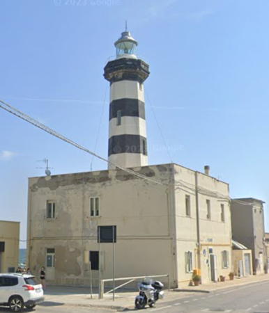
* Ortona
1937. Active; focal plane 23 m (75 ft); two white flashes every 6 s. 25 m (82 ft) octagonal concrete tower with lantern and gallery, rising from a 2-story concrete keeper's house. Tower and the seaward side of the house painted with black and white horizontal bands; lantern dome is gray metallic. A 2021 closeup photo is at right, Vito Manzari has a photo, Trabas has a good closeup photo, Wikimedia has a photo, and Google has a street view and a satellite view. Somehow this lighthouse managed to survive a ferocious battle between Allied and German forces in September 1943. Located on the Via del Porto at the base of the north mole in Ortona. Site open, tower closed. . ARLHS ITA-108; EF-3864; Admiralty E2312; NGA 11128.

Ortona Light, Ortona, August 2021
Google Maps photo by Dony
* Ortona Molo Nord
Date unknown. Active; focal plane 9 m (30 ft); green flash every 3 s. 7 m (23 ft) round concrete tower with lantern and gallery, painted green; lantern dome is gray metallic. Trabas has a good photo, a 2008 photo is available, and Google has a satellite view. Located at the end of the north breakwater at Ortona. Probably accessible by walking the pier. Site status unknown. EF-3865; Admiralty E2313; NGA 11132.
* Ortona Molo Sud
Date unknown. Active; focal plane 9 m (30 ft); red flash every 3 s. 7 m (23 ft) round concrete tower with lantern and gallery, painted red; lantern dome is gray metallic. Trabas has a good photo, Diego Stellino has a 2017 street view, and Google has a satellite view. Located at the end of the south breakwater at Ortona. Accessible by walking the pier. Site open, tower closed. EF-3866; Admiralty E2314; NGA 11140.
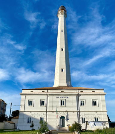
* Punta Penna (2)
1948 (station established 1906). Active; focal plane 84 m (276 ft); white flash every 5 s. 70 m (230 ft) octagonal concrete tower with lantern and gallery, rising from the center of a 2-story masonry keeper's house. The lighthouse is white concrete; lantern dome is gray metallic. Trabas has a fine closeup photo by Meyers, a 2020 closeup photo is available, a 2008 photo is available, Huelse has a historic postcard view, and Google has a street view and a satellite view. This is the second tallest Italian lighthouse after the Laterna di Genova. The original lighthouse was nearly destroyed by retreating German troops in 1944. The ruins were demolished in 1946, and the new lighthouse was built on the design of architect Olindo Tarcione. Located on the Via Madonna della Penna in Porto di Vasto, on a prominent cape about 7 km (4.5 mi) north of Vasto, a city of about 40,000 residents. Site open, tower closed. . ARLHS ITA-138; EF-3856; Admiralty E2306; NGA 11100.

Lighthouses of Molise

Campobasso Province Lighthouses
* Termoli
1963. Active; focal plane 41 m (135 ft); two white flashes every 10 s. 17 m (56 ft) square skeletal tower with lantern and gallery, mounted on a 1-story square concrete equipment shelter. Lighthouse painted white. Trabas has Capt. Peter's photo, Alessio Cavallone has a 2023 photo, Antonio Augelli has a 2008 photo, Simon Francesco has a closeup, Google has a March 2011 street view of the lighthouse surrounded by scaffolding during a restoration, and Google also has a satellite view. Sibling of the 1960 Cattolica lighthouse (see above). Located at the foot of the Via Federico di Svevia on the waterfront in the resort town of Termoli. Site open, tower closed. . ARLHS ITA-167; EF-3846; Admiralty E2303; NGA 11080.
* Termoli Molo Sud
1963. Active; focal plane 9 m (30 ft); two yellow flashes every 6 s. 7.5 m (25 ft) round "bottle" style light mounted on a 1-story square concrete equipment shelter. Formerly painted red, the lighthouse was repainted yellow in 2016. Trabas has Capt. Peter's photo of the lighthouse and Google has a street view and a satellite view. Located at the end of the south (inner) breakwater in Termoli. Site open, tower closed. EF-3850; Admiralty E2305; NGA 11092.

Punta Penna Light, Vasto, February 2007
Wikimedia Creative Commons photo by Luca

Information available on lost lighthouses:

Notable faux lighthouses:

Adjoining pages: North: Venice and Trieste | South: Northern Puglia

Return to the Lighthouse Directory index | Ratings key

Posted August 21, 2006. Checked and revised January 9, 2024. Lighthouses: 35. Site copyright 2024 Russ Rowlett and the University of North Carolina at Chapel Hill.