Lighthouses of Italy: Northern Puglia (Apulia)

Most of Italy (officially the Italian Republic, Repubblica Italiana in Italian) occupies a long peninsula in the Mediterranean Sea, with the Adriatic and Ionian Seas on the east and the Ligurian and Tyrrhenian Seas to the west; the country also includes the Mediterranean's two largest islands, Sicily and Sardinia, and many smaller islands. With this geography Italy has a very long coastline reckoned by geographers at about 7600 km (4722 mi). Guarding this coast are many lighthouses; the Directory lists more than 400.

Italy is divided into 20 regions (regioni), many of them well known outside the country in their own right, and the regions are subdivided into provinces. This page includes the lighthouses of the northern part of the Italian region of Puglia (commonly known in English as Apulia), including the provinces of Foggia and Barletta-Andria-Trani and the Metropolitan City of Bari. This portion of Puglia faces northeast on the Adriatic Sea. The city of Bari is the most important port of the region, but there are many other ports.

Prior to the unification of Italy in 1861 all of Puglia was part of the Kingdom of Naples until the end of the Napoleonic Wars (1803-1815) when the Kingdom of Naples merged with Sicily to form the Kingdom of the Two Sicilies.

The Italian word for a lighthouse is faro, plural fari. This name is usually reserved for the larger coastal lights; smaller beacons are called fanali. In Italian isola is an island, isolotto is an islet, secca is a shoal, cabo is a cape, punta is a point of land, baia is a bay, stretto is a strait, fiume is a river, and porto is a harbor.

Aids to navigation in Italy are operated and maintained by the Italian Navy's Servizio dei Fari e del Segnalamento Marittimo (Lighthouse and Maritime Signal Service). Lighthouse properties are naval reservations, generally fenced and closed to the public.

ARLHS numbers are from the ARLHS World List of Lights. EF numbers are from the Italian Navy's light list, Elenco Fari. Admiralty numbers are from volume E of the Admiralty List of Lights & Fog Signals. U.S. NGA List numbers are from Publication 113.

General Sources
Online List of Lights - Italy
Photos by various photographers posted by Alexander Trabas. Most of the photos from this area are by Capt. Peter Mosselberger ("Capt. Peter").
Fari e Segnalamenti
Lighthouse information from the Italian Navy's Servizio dei Fari.
Lighthouses in Italy
Photos by various photographers available from Wikimedia.
World of Lighthouses - Italy
Photos by various photographers available from Lightphotos.net.
Italy Lighthouses
Aerial photos posted by Marinas.com.
Italienische Leuchttürme auf Historischen Postkarten
Historic postcard images posted by Klaus Huelse.
GPSNauticalCharts
Navigational chart information for Italy.
Navionics Charts
Navigational chart for Italy.


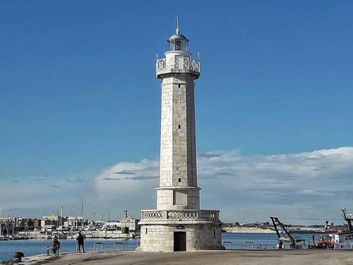
Molo di Tramontana Light, Barletta, 2015
photo copyright Capt. Peter Mosselberger; used by permission

Foggia Province Lighthouses

Tremiti Islands Lighthouses
Between the Gargano Peninsula and the Croatian coast the Adriatic Sea is relatively shallow and a number of small islands pose serious hazards to navigation. The islands on the Italian side are called the Isole Tremiti--Trembling Islands--because of the frequency of minor earthquakes. There are five islands, all included in the Gargano National Park. The two inhabited islands, San Domino and San Nicola, are tourist destinations accessible by ferry from Tremoli.
Isola di San Domino (Punta del Diavolo) (1)
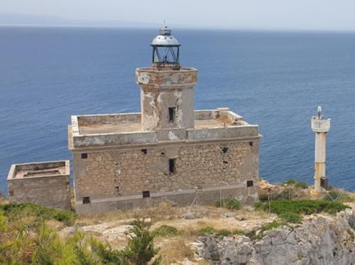
1905. Inactive since 1987. Approx. 9 m (30 ft) octagonal cylindrical masonry tower with lantern and gallery centered on the roof of a 1-story masonry keeper's house. The lighthouse was probably painted white, but it is unpainted today. Fabiano Baderna's photo is at right, Paolo Cacciapuoti has a July 2021 closeup photo, another good photo and a 2008 photo are available, and Google has a satellite view of the station. Gravely endangered. The lighthouse was heavily damaged by an explosion in 1987 and remains in a very dilapidated condition. The building seems more or less intact in Paolo Cacciapuoti's July 2021 closeup photo but a September 2021 photo shows new damage (perhaps from an earthquake) and the lantern appears to have fallen from the tower. The property was for sale in 2005 but it did not sell. Located at the southwestern point of the island, marking the safe passage south of the island group. Site appears open, tower closed. ARLHS ITA-245.
Isola di San Domino (Punta del Diavolo) (3)
2021. Active; focal plane 48 m (157 ft); three white flashes every 10 s. 9 m (30 ft) round white metal or fiberglass tower. A September 2021 closeup photo is available. This light replaced the 1987 light, a 9 m (30 ft) round post. Fabiano Baderna's photo is at right, Trabas has Capt. Peter's photo of the 1987 light and Paolo Cacciapuoti's July 2021 closeup photo shows that light still in place. Located next to the historic lighthouse. Site appears open, tower closed. EF-3844; Admiralty E2294; NGA 11076.
* Isola San Nicola
Date unknown. Active; focal plane 89 m (279 ft); four white flashes every 15 s. 15 m (49 ft) square skeletal tower painted with red a snd white horizontal bands. Several 1-story station buildings. Trabas has Capt. Peter's photo, a distant view is available, and Google has a satellite view of the station. Located at the highest point of San Nicola. Accessible by road. Site and tower closed, but the light tower is easily seen from the surrounding area. ARLHS ITA-274; EF-3838; Admiralty E2297; NGA 11072.
 

Old and new San Domino Lights, Tremiti Islands, July 2019
Google Maps photo by Fabiano Baderna
Isola di Capraia (Caprara) (1)
1868. Inactive since 1980. Approx. 15 m (49 ft) octagonal cylindrical masonry tower, attached to a 2-story masonry keeper's house. Lantern removed. The lighthouse was probably painted white, but it appears unpainted today. The abandoned lighthouse is gravely endangered; Antonio Napolitano's 2018 photo at right shows it to be falling into ruin. Rev. Santino di Renzo has a 20006 photo, Ricardo A. Valle has a view from the sea, and Google has a satellite view.The uninhabited island of Capraia is north of San Nicola, separated by a channel about 800 m (1/2 mi) wide. Note: there is another Isola Capraia in the Tuscan Archipelago off Tuscany. Located at the eastern tip of the island. Accessible only by boat. Site and tower closed. ARLHS ITA-207.
Isola di Capraia (Caprara) (3)
2019 (station established 1868). Active; focal plane 23 m (75 ft); white flash every 5 s. 10 m (33 ft) round barbell-shaped white fiberglass tower. Glauco Sbaccheri has a distant 2019 view from the sea and Google has a satellite view. This light replaced a square skeletal tower with an enclosed lower section; Trabas has Capt. Peter's photo and the skeletal light is seen in Antonio Napolitano's 2018 photo. Located in front of the historic lighthouse. Site and tower closed. EF-3836; Admiralty E2296; NGA 11064.
Isola di Pianosa (2)
1948 (station established 1914). Inactive. 17 m (56 ft) round cylindrical concrete tower with lantern and gallery, attached to a 1-story keeper's house. Lighthouse painted white. Maurizio Marrese has a 2018 photo of the two Pianosa lighthouses, another photo of the two lighthouses is available, and Google has a satellite view. The most remote of the islands, Pianosa is especially dangerous because its low elevation makes it difficult to see at a distance. In 1953 a building was built to serve as a shelter for fishermen who might be stranded on the island. This building and the keeper's house have been damaged by storms that sometimes sweep over the island. Note: there is another, better known Isola Pianosa in the Tuscan Islands off the west coast of Italy (see Tuscany). Located about 22 km (14 mi) east northeast of the other islands of the group. Accessible only by boat. Site and tower closed. ARLHS ITA-212.

Capraia Light, Tremiti Islands, August 2018
Google Maps photo by Antonio Napolitano
Isola di Pianosa (3)
Date unknown (station established 1914). Active; focal plane 25 m (82 ft); two white flashes every 10 s. Approx. 24 m (79 ft) square skeletal tower. Maurizio Marrese has a 2018 photo of the two Pianosa lighthouses and Google has a satellite view. Located next to the historic lighthouse. EF-3832; Admiralty E2300; NGA 11060.

Gargano Peninsula Lighthouses
The Gargano Peninsula is a mountainous peninsula that projects 40 km (25 mi) eastward into the Adriatic Sea north of Manfredonia.
Vieste (Isola Santa Eufemia)
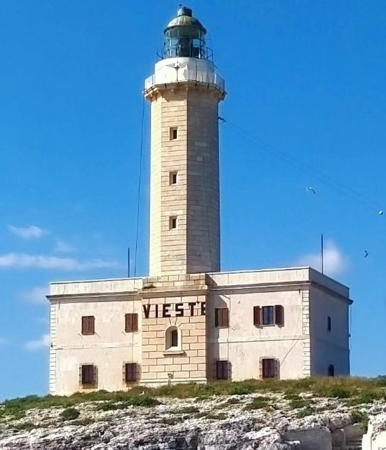
1867 (Francesco Saverio Gatta). Active; focal plane 40 m (131 ft); three white flashes every 15 s. 27 m (90 ft) octagonal cylindrical masonry tower with lantern and gallery, rising from a 2-story masonry keeper's house. The original 1st order Fresnel lens remains in use. The lighthouse is unpainted white stone; watch room painted white; lantern dome is gray metallic. Wilma Mattivi's 2023 photo is at right, Massimo D'Alessandro has a 2019 photo, Roberto Ferrari has a photo, Trabas has a good photo by Capt. Peter, Marinas.com has aerial photos, Paolo Tamagnini has a street view, and Google has a good satellite view. This is one of the most important lighthouses of the Adriatic, warning ships away from the Gargano Peninsula. Located on a small island, the Isola Sant'Eufemia, just off the waterfront of Vieste at the northeastern tip of the peninsula. Accessible only by boat. Site and tower closed but there are excellent views from shore. . ARLHS ITA-090; EF-3816; Admiralty E2288; NGA 11040.
Torre Preposti (2)
1946 (station established 1937). Active; focal plane 62 m (203 ft); white flash every 5 s. 22 m (72 ft) square cylindrical tower with lantern, rising from one corner of a 1-story keeper's house, all mounted on a massive square stone foundation. Lighthouse painted white; lantern dome is gray metallic. Trabas has a good photo, Rosario Barone has a 2018 view from the sea below, Ed Ward has a 2021 photo from below, and Google has a satellite view. The lighthouse is built atop an Aragonese watchtower dating from around 1500. Located on a steep slope at Testa del Gargano, the easternmost point of the peninsula. The lighthouse is difficult to reach, but it can be seen from above on twisting mountain roads. Site status unknown. ARLHS ITA-169; EF-3812; Admiralty E2286; NGA 11036.
* Manfredonia Molo di Levante
Date unknown. Active; focal plane 14 m (46 ft); green flash every 3 s. 12.5 m (41 ft) round cylindrical concrete tower with lantern and gallery. The lighthouse is unpainted white concrete. Trabas has a good photo by Capt. Peter, a 2020 closeup is available, Pasquale Li Bergoli has a street view, and Google has a satellite view. Located at the end of the east mole of Manfredonia, a city of about 60,000 residents. Accessible by walking the mole. Site open, tower closed. EF-3800; Admiralty E2277; NGA 11016.
* Manfredonia
1868 (extensively rebuilt in 1947). Active; focal plane 20 m (66 ft); white flash every 5 s. 18 m (60 ft) octagonal cylindrical masonry tower with lantern and gallery, rising from a 2-story masonry keeper's house. Entire lighthouse painted white. Trabas has a good photo by Günther Hess, a 2017 closeup and a 2007 photo of the lighthouse in action are available, and Google has a 2023 street view and a satellite view. The lighthouse was heavily damaged in 1943, during World War II, and was rebuilt after the war. Located near the base of the east mole of Manfredonia, a wide mole that includes a street and has a public beach on the east side. Site open, tower closed. . ARLHS ITA-099; EF-3796; Admiralty E2276; NGA 11012.

Vieste Light, Vieste, July 2023
Instagram photo by Wilma Mattivi
* Manfredonia Molo di Ponente (Molo di Mezzogiorno)
Date unknown (1947?). Active; focal plane 11 m (36 ft); red flash every 3 s. 10 m (33 ft) round cylindrical concrete tower with lantern and gallery. The lighthouse is unpainted white concrete; lantern painted red. Gioele Giacometti has a 2023 photo, Trabas has a good photo by Capt. Peter, and Google has a satellite view and a distant street view. Located at the end of the west mole of Manfredonia. Accessible by walking the mole. Site open, tower closed. EF-3804; Admiralty E2278; NGA 11020.
Foce Aloisa
Date unknown. Active (privately maintained); focal plane 16 m (52 ft); continuous red light. Light mounted atop a 2-story square pierhead building. Trabas has Capt. Peter's photo and Google has a street view and a satellite view. Located at the end of a pier about 5 km (3 mi) southeast of Zapponeta. Site and tower closed. Admiralty E2275; NGA 11008.

Barletta-Andria-Trani Province Lighthouses

Barletta Lighthouses
* Chiesa dei Monaci
Date unknown. Inactive at least since 2015 but listed by NGA with a continuous white light. The light was mounted on the dome of a church, the Chiesa dei Monaci. Trabas has Capt. Peter's photo and Google has a street view and a satellite view. Andreas Köhler visited this site in 2015 and reported that the only light in evidence was the spotlight illuminating the cross atop the church. Later that year Capt. Peter reported that the light, a "simple street lantern" mounted near the cross, remained out of service. The Admiralty dropped the light from its list in June 2017. Located on the Via Milano at the Via Firenze in downtown Barletta. Site open, tower closed. ex-Admiralty E2263.5; NGA 10992.
* Barletta (Molo di Tramontana) (2)
1959 (station established 1807). Active; focal plane 30 m (98 ft); two long (2 s) flashes every 12 s. 28 m (92 ft) octagonal masonry tower mounted on a square stone base. The tower is unpainted white stone; lantern dome is gray metallic. Trabas has an excellent photo by Capt. Peter (also seen at the top of this page), Enrico Gissi has a fine 2008 photo, a 2023 photo is available, Marinas.com has aerial photos, and Google has a street view and a satellite view. Located near the end of the west breakwater of Barletta. Site open, tower closed. ARLHS ITA-228; EF-3780; Admiralty E2264; NGA 10984.
* Barletta Molo di Tramontana Pierhead
Date unknown. Active; focal plane 12 m (39 ft); green flash every 4 s. 11 m (36 ft) "bottle" style post atop a round stone pierhead building. Light tower painted green. Trabas has a closeup photo by Capt. Peter and Google has a satellite view. Located at the end of the mole below the historic lighthouse. Site open, tower closed. EF-3782; Admiralty E2266; NGA 10988.
* Barletta (Faro Napoleon) (1)
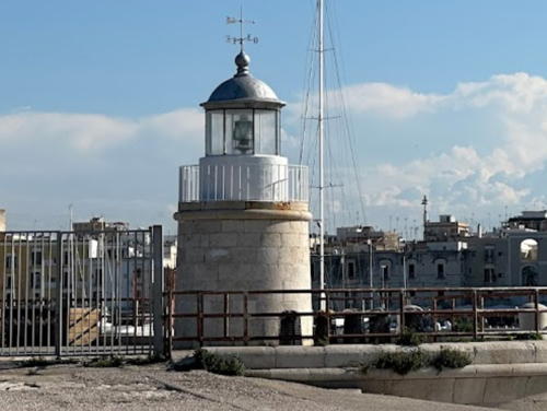
1807 (Domenico Luigi Chiarelli). Inactive since 1959. Approx. 15 m (49 ft) stone tower, lower half square and upper half round, with lantern and gallery, attached to a 2-story keeper's house. The tower is unpainted; lantern dome is gray metallic. Evgeny Tretyakov's 2023 photo is at right, Emrah Aytemiz has a 2016 photo, and Google has a satellite view. The keeper's house is of 20th century construction; Huelse has a historic postcard view in which the house does not appear. The house remained in use until the newer lighthouse was automated. The lighthouse is known locally as the Faro Napoleon because it was ordered built by Joseph Napoleon, brother of the French emperor and then King of Naples. Located near the base of the Molo di Tramontana, the west breakwater of Barletta. Site open, tower closed. ARLHS ITA-313.

1807 Barletta Light (Faro Napoleon), Barletta, October 2023
Google Maps photo by Evgeny Tretyakov
Trani Lighthouses
Trani Braccio di San Nicola
Date unknown. Active; focal plane 11 m (36 ft); green light, 2 s on, 3 s off. 7 m (23 ft) round concrete tower with gallery and a small lantern on a post. Entire lighthouse painted bright green. Trabas has Eckhard Meyer's photo, Vittorio-Luigi Collarini has a 2020 closeup, and Google has a satellite view and a closeup street view. Located at the end of the main (west) breakwater, the Molo Grande di San Nicola, at Trani. Site and tower closed. ARLHS ITA-320; EF-3776; Admiralty E2262; NGA 10980.
Trani Molo San Antonio Interno
Date unknown. Active; focal plane 8 m (26 ft); continuous red light. 7 m (23 ft) round concrete tower with gallery and a small lantern on a post. Entire lighthouse painted bright red. Trabas has Eckhard Meyer's photo, Daniel Zollinger has a 2009 photo, Roberto Moscatelli has a closeup street view, and Google has a satellite view. Located at the end of the extension of the east breakwater, the Molo San Antonio, at Trani. Site and tower closed. ARLHS ITA-321; EF-3772; Admiralty E2261; NGA 10972.
* Trani (Molo San Antonio)
1885. Active; focal plane 9 m (30 ft); white flash every 5 s. 5 m (16 ft) round stone tower with lantern and gallery. Tower unpainted; lantern is white with a gray metallic dome. Carmelo Tommaso Russo's 2023 photo is at right, Trabas has Eckhard Meyer's closeup, Lightphotos.net has a closeup, and Google has a street view and a satellite view. Located at the original end of the east breakwater, the Molo San Antonio, at Trani. Accessible by walking the mole. Site open, tower closed. ARLHS ITA-272; EF-3771; Admiralty E2260; NGA 10976.

Molo San Antonio Light, Trani, May 2023
Google Maps photo by Carmelo Tommaso Russo

Metropolitan City of Bari Lighthouses

The Metropolitan City of Bari replaced the former Bari Province in 2015. The metropolitan city has a population of about 1.3 million. The city of Bari itself, the capital of the Puglia Region, is a major port and university city and the terminal for more than 20 ferry routes crossing the Adriatic to Croatia, Montenegro, Albania, and Greece.

Molfetta Lighthouses
* Molfetta Molo Pennello
Date unknown. Active; focal plane 5 m (17 ft); continuous green light. 4 m (13 ft) post centered on a round 1-story concrete equipment building. Lighthouse painted green. Trabas has a photo by Capt. Peter, Gianni Grillo has a street view, and Google has a satellite view. Located at the end of the west inner breakwater at Molfetta. Accessible by walking the mole. Site open, tower closed. EF-3760; Admiralty E2254; NGA 10964.
* Molfetta Molo Foraneo
Date unknown (station established 1888). Active; focal plane 12 m (39 ft); red flash every 5 s. 10 m (33 ft) round cylindrical tower with lantern. Upper 2/3 of the tower painted red, lowest third unpainted; lantern dome is gray metallic. Trabas has a photo by Capt. Peter and Google has a satellite view. Located at the end of the breakwater (the Molo San Michele) at Molfetta. Accessible by walking the mole. Site open, tower closed. ARLHS ITA-317; EF-3756; Admiralty E2252; NGA 10956.
* Molfetta
1853 (relocated here in 1857). Active; focal plane 20 m (66 ft); white light, 3 s on, 3 s off. 19 m (62 ft) octagonal masonry tower with lantern and gallery, mounted on a circular 1-story masonry base. 3rd order Fresnel lens in use. The lighthouse is white stone; lantern dome is gray metallic. Antonio Lucasette's photo is at right, Trabas has a good photo by Capt. Peter, Manuhar Auroville has a 2008 photo, a 2023 photo and a 2019 photo are available, Marinas.com has aerial photos, and Google has a closeup street view and a satellite view. The lighthouse was originally built on the Molo Tramontana on the west side of the harbor. After fishermen following its light wrecked on the shore instead of finding the harbor, it was demolished and rebuilt at its present site. Located at an elbow of the Molo San Michele, which shelters the harbor at Molfetta. Accessible by walking the mole. Site open, tower closed. . ARLHS ITA-224; EF-3752; Admiralty E2248; NGA 10952.

Molfetta Light, Molfetta, January 2021
Instagram photo by Antonio Lucasette

Bari Lighthouses
* Bari (Punta San Cataldo)
1869. Active; focal plane 66 m (217 ft); three white flashes every 20 s. 62 m (203 ft) octagonal stone tower with lantern and gallery, rising from a 2-story masonry keeper's house. The entire lighthouse is white; lantern dome is gray metallic. Claudia Rizzitano 's photo is at right, Trabas has a photo by Klaus Potschien, a 2008 photo is available, Nino Colaianni has a good 2021 photo, Wikimedia has a good photo, Marinas.com has aerial photos, and Google has a fine street view and a closeup satellite view. This tall lighthouse could be confused with the shorter San Cataldo di Lecce Light (see the Southern Puglia page). It guides ships to the harbor of Bari, the most important port of Puglia and the terminus for trans-Adriatic ferries. Located on Punta San Cataldo, at the base of the Molo San Cataldo, on the west side of the harbor of Bari. Site open, tower closed. . ARLHS ITA-141; EF-3706; Admiralty E2232; NGA 10892.
Bari Molo Borbonico (1)
Date unknown. Inactive since 2005. Approx. 11 m (36 ft) round masonry tower with lantern and gallery, rising from a 1-story building. Lighthouse formerly painted with black and white horizontal bands but now unpainted; the lantern dome was gray metallic. The active light (focal plane 8 m (26 ft); continuous green light) is on a 6 m (20 ft) green post. Josep Manuel Mercader has a twilight photo and Google has a satellite view. This light and the next one are often confused on the Internet. Trabas has Capt. Peter's photo of the current light. Located on the inner west mole at Bari. Site closed. ARLHS ITA-311. Active light: EF-3730; Admiralty E2242; NGA 10928.
Bari Vecchio Molo Foraneo (Faro Pizzoli)
1913. Inactive. Approx. 11 m (36 ft) round masonry tower with lantern and gallery. Formerly painted white, the lighthouse is now unpainted; lantern dome is gray metallic. The active light (focal plane 11 m (36 ft); two continuous red lights, one above the other) is on a 4 m (13 ft) red post beside the lighthouse. Leo Magarelli has a photo, Agostino Brienza has a good 2017 photo, Vincent Tévé has a 2014 photo, and Google has a satellite view. Trabas has Capt. Peter's photo of the current light. Located at the end of the old east breakwater mole, which now extends into the center of the modern harbor of Bari. Site and tower closed. ARLHS ITA-312. Active light: EF-3724; Admiralty E2238; NGA 10920.
* Bari Molo San Antonio
Date unknown. Active; focal plane 17 m (56 ft); green flash every 5 s. 14 m (46 ft) round cylindrical masonry tower with lantern and gallery. The lighthouse is unpainted except for a narrow green band near the top of the tower. Trabas has a photo, Krzysztof Ulanowski has 2021 closeup, a 2023 photo and a distant view are also available, Dong Hyun Park has a street view, and Google has a satellite view. Located at the end of the Molo San Antonio, which encloses the old harbor, now the small boat harbor, on the east side of Bari. Accessible by walking the pier. Site open, tower closed. ARLHS ITA-234; EF-3742; Admiralty E2244; NGA 10932.

Punta San Cataldo Light, Bari, September 2019
Instagram photo by Claudia Rizzitano

Mola di Bari and Monopoli Lighthouses
* Mola di Bari (Molo Nord)
Date unknown (station established 1901). Active; focal plane 13 m (43 ft); green flash every 3 s. 10 m (33 ft) square cylindrical skeletal tower centered on a square 1-story masonry equipment building. Skeletal tower painted green. Trabas has Capt. Peter's photo, Francesco Silvini has a closeup street view, and Google has a satellite view and a distant street view. Located at the end of the north (really west) breakwater at Mola di Bari, a fishing port about 16 km (10 mi) southeast of Bari. Accessible by walking the mole. Site open, tower closed. EF-3700; Admiralty E2228; NGA 10876.
Polignano a Mare Inner Mole (2)
2013 (?). Active (privately maintained); focal plane 8 m (26 ft); continuous white light. 6 m round tower colored with red and white horizontal bands. Trabas has Capt. Peter's photo and Google has a satellite view. The Admiralty lists a "red post" with a continuous red light at this location. Located on a quay at Polignano a Mare, about 10 km (6 mi) northwest of Monopoli. Site and tower closed (private pier). EF-3697.3; Admiralty E2227.1.
* Monopoli (Molo Margherita)
1878. Active; focal plane 15 m (49 ft); red flash every 3 s. 15 m (49 ft) hexagonal masonry tower with lantern and gallery, painted with red and white horizontal bands. Elisabetta Stringhi's photo is at right, Trabas has a good photo by Capt. Peter, Jarrod Hunt has a 2019 closeup, another photo is available, and Google has a 2020 street view and a satellite view. Google's 2022 street view shows the lighthouse under restoration. This lighthouse was built by local port authorities and transferred to the Navy's control in 1911. Located at the end of the Molo Margherita, the traditional breakwater mole of Monopoli, at the south side of the entrance to the harbor. Accessible by walking the mole. Site open, tower closed. . ARLHS ITA-232; EF-3692; Admiralty E2224; NGA 10868.

Molo Margherita Light, Monopoli, August 2014
Flickr Creative Commons photo by Elisabetta Stringhi

Information available on lost lighthouses:

Notable faux lighthouses:

Adjoining pages: North: Eastern Italy | South: Southern Puglia

Return to the Lighthouse Directory index | Ratings key

Posted August 10, 2006. Checked and revised January 16, 2024. Lighthouses: 30. Site copyright 2024 Russ Rowlett and the University of North Carolina at Chapel Hill