Lighthouses of Italy: Calabria and Basilicata

Most of Italy (officially the Italian Republic, Repubblica Italiana in Italian) occupies a long peninsula in the Mediterranean Sea, with the Adriatic and Ionian Seas on the east and the Ligurian and Tyrrhenian Seas to the west; the country also includes the Mediterranean's two largest islands, Sicily and Sardinia, and many smaller islands. With this geography Italy has a very long coastline reckoned by geographers at about 7600 km (4722 mi). Guarding this coast are many lighthouses; the Directory lists more than 400.

Italy is divided into 20 regions (regioni), many of them well known outside the country in their own right. The region of Calabria is the "toe" of the Italian boot, located in the south of the country northeast of the island of Sicily. Basilicata (or Lucania) is the adjoining region to the north, more or less in the "arch" of the boot. Historically Calabria and Basilicata were for many years part of the Kingdom of Naples, ruled by monarchs of the House of Bourbon. In 1816, following the Napoleonic wars, Calabria and Basilicata were included with Campania (Naples) and Sicily in the Bourbon state known as the Kingdom of the Two Sicilies. During Italy's unification the Kingdom of the Two Sicilies was conquered by Sardinia in 1860-61 and incorporated in the new Kingdom of Italy in 1861.

Calabria has a long coastline facing the Tyrrhenian Sea to the west, the Ionian Sea to the southeast, and the Gulf of Taranto to the northeast. Basilicata is mostly an inland region, with very short coastlines on the Tyrrhenian Sea and Gulf of Taranto.

The Italian word for a lighthouse is faro, plural fari. This name is usually reserved for the larger coastal lights; smaller beacons are called fanali. In Italian isola is an island, isolotto is an islet, secca is a shoal, cabo is a cape, punta is a point of land, baia is a bay, stretto is a strait, fiume is a river, and porto is a harbor.

Aids to navigation in Italy are operated and maintained by the Italian Navy's Servizio dei Fari e del Segnalamento Marittimo (Lighthouse and Maritime Signal Service). Lighthouse properties are naval reservations, generally fenced and closed to the public.

ARLHS numbers are from the ARLHS World List of Lights. EF numbers are from the Italian Navy's light list, Elenco Fari. Admiralty numbers are from volume E of the Admiralty List of Lights & Fog Signals. U.S. NGA List numbers are from Publication 113.

General Sources
Fari e Segnalamenti
Lighthouse information from the Italian Navy's Servizio dei Fari.
Online List of Lights - Italy
Photos by various photographers posted by Alexander Trabas. For this region many of the photos are by Capt. Peter Mosselberger ("Capt. Peter").
Cyberlights Lighthouses - Italy
Photos of Italian lighthouses by Egidio Ferrighi, posted by Gary Richardson and Anna Klein.
Italy Lighthouses
Aerial photos posted by Marinas.com.
Lighthouses in Italy
Photos by various photographers available from Wikimedia.
World of Lighthouses - Italy
Photos by various photographers available from Lightphotos.net.
Italienische Leuchttürme auf Historischen Postkarten
Historic postcard images posted by Klaus Huelse.
GPSNauticalCharts
Navigational chart information for southern Italy.
Navionics Charts
Navigational chart for Calabria.


Capo Colonne Light, Crotone, May 2021
Instagram photo by patr.i6685
Lighthouses of Basilicata

Matera Province Lighthouse
** Scanzano Jonico (Torre della Scanzana, Torre Faro)
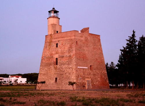
Date unknown (1930s?). Inactive for many years. Approx. 21 m (69 ft) round cylindrical light tower with lantern mounted at one corner of a massive square pyramidal stone fortified tower. The fort is unpainted stone; the tower is painted white; lantern roof painted black. Mariagrazia Brunetti's photo is at right, Antonio Francesco has a photo, an Italian wiki site has a fine closeup, and Google has a street view and a satellite view. The tower is the Torre della Scanzana, built on orders of the Spanish viceroy in the mid 16th century. It is not known when the light tower was added or how long it remained in use. The absence of information in older light lists suggests it was only active for a few years. The tower was in danger of destruction in connection with the proposed construction nearby of Italy's nuclear waste depository. Public protests led instead to its recognition as a historic monument and to its restoration. During the restoration the light tower's gallery was removed. Located just off the Via Lido-Torre at Scanzano Jonico. Site open; the tower is reported to be open for tours. ARLHS ITA-318.

Lighthouses of Calabria

Cosenza Province: East Coast (Golfo di Taranto) Lighthouses
Cosenza spans the upper end of the "foot" of Italy; it also has a west coast on the Tyrrhenian Sea. Lighthouses of that coast are listed near the bottom of this page.

*
Punta Coscio (Marina Laghi di Sibari)
Date unknown (modern). Active (privately maintained); focal plane 23 m (75 ft); four white flashes every 20 s. Approx. 15 m (49 ft) light mounted atop an observation cupola on the roof of a 3-story marina building. Trabas has a closeup photo and Google has a street view and a satellite view. This light is part of a large marina complex dredged from low-lying land. Located about 2.5 km (1.5 mi) northwest of Punta Coscio and the same distance southeast of the town of Marina di Sibari. Site open; tower closed. Owner/site manager: Marina Laghi di Sibari. ARLHS ITA-308; Admiralty E2130.5; NGA 10630.

Scanzano Light, Scanzano Jonico, September 2019
Wikimedia Creative Commons photo by Mariagrazia Brunetti
* Porto di Corigliano North Mole
Date unknown. Active (privately maintained); focal plane about 15 m (49 ft); green flash every 3 s. 6 m (20 ft) round concrete tower with lantern and gallery, painted green. Trabas has Capt. Peter's photo and Google has a satellite view. Formerly unpainted, the tower was painted in 2012. Located at the end of the south mole of Porto di Corigliano, an artificial harbor at Torricella Inferiore, about 8 km (5 mi) north of Corigliano Calabro. Accessible by walking the mole. Site open, tower closed. EF-3429.2; Admiralty E2130.3.
* Porto di Corigliano South Mole
Date unknown. Active (privately maintained); focal plane about 15 m (49 ft); red flash every 3 s. 6 m (20 ft) round concrete tower with lantern and gallery, painted red. Trabas has Capt. Peter's photo and Google has a satellite view. Formerly unpainted, the tower was painted in 2012. Located at the end of the south mole of Porto di Corigliano, an artificial harbor at Torricella Inferiore, about 8 km (5 mi) north of Corigliano Calabro. Accessible by walking the mole. Site open, tower closed. EF-3429; Admiralty E2130.2.
* Corigliano Calabro
Date unknown. Apparently inactive (privately maintained; charted as a landmark). 19 m (62 ft) octagonal unpainted concrete tower with lantern and gallery. Eric Somsois has a 2006 photo and Google has a satellite view and a very distant street view. This lighthouse is something of a mystery. It was listed by the Admiralty in November 2013 with focal plane 20 m (66 ft); continuous white, red or green light, depending on direction; then it was delisted six weeks later. Located on the south quay at Porto di Corigliano. Site open, tower closed. ex-Admiralty E2130.1.
* Capo Trionto
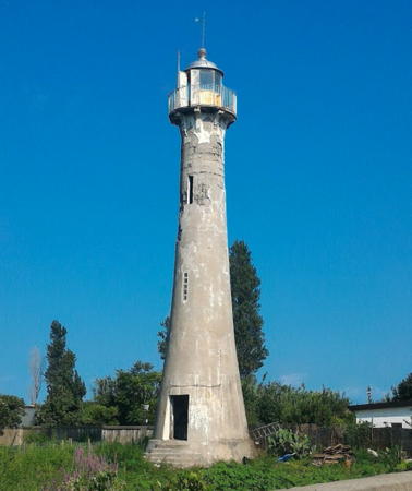
1923. Inactive since 2005, although charted as active by Navionics. 18 m (59 ft) round tapered tower with lantern and gallery. The lighthouse was originally painted white, but the paint has worn off; the lantern dome is gray metallic. Roberto Buanne has the photo at right, Aniello Striano has a 2018 photo, Rita Tupputi has a 2020 photo, a portfolio of photos is available, and Google has a street view and a satellite view. Endangered: this lighthouse is abandoned and deteriorating. Located on a cape on the west side of the Golfo di Taranto in Mirto. Site open, tower closed. . ARLHS ITA-191; ex-EF-3428; ex-Admiralty E2130; ex-NGA 10628.

Capo Trionto Light, Mirto, August 2016
Google Maps photo by Roberto Buanne

Crotone Province (Ionian Sea) Lighthouses
* Punta Alice
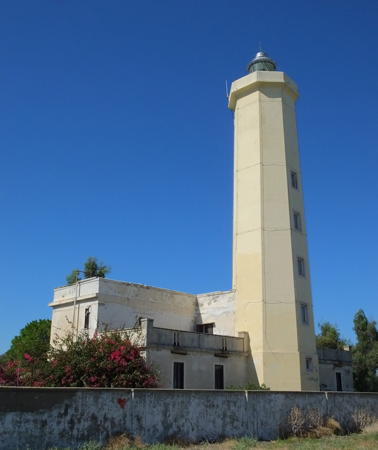
1896. Active; focal plane 31 m (102 ft); two white flashes every 10 s. 27 m (88 ft) octagonal cylindrical masonry tower with lantern and gallery attached to a 2-story masonry keeper's house. Entire lighthouse painted white; lantern dome is gray metallic. Trabas has the good photo by Capt. Peter seen at right, Giuseppe Grillo has a 2022 photo, Gianni Maggiolo also has a 2022 photo, Marinas.com has aerial photos, and Google has a street view and a satellite view. This lighthouse marks the western entrance to the Golfo di Taranto. Located on a prominent but low cape about 5 km (3 mi) north of Cirò Marina. The lighthouse grounds appear to be closed but there are good views from nearby. . ARLHS ITA-122; EF-3424; Admiralty E2128; NGA 10624.
* Crotone Molo Vecchio (Bacino Sud)
Date unknown (station established 1872). Active; focal plane 11 m (36 ft); two green flashes every 5 s. 7 m (23 ft) post centered on a square 1-story equipment equipment building. Entire lighthouse painted green. Trabas has Capt. Peter's closeup photo, Giuseppe Franco has a street view, and Google has a satellite view. Located at the end of the breakwater of the older harbor at Crotone. Accessible by walking the pier. Site open, tower closed. EF-3408; Admiralty E2122; NGA 10604.
* Crotone Molo Sanità
Date unknown. Active; focal plane 9 m (30 ft); two red flashes every 5 s. 7 m (23 ft) post centered on a square 1-story equipment equipment building. Entire lighthouse painted red. Trabas has a closeup photo by Capt. Peter, Cosimo Risoleo has a street view, and Google has a satellite view. Located on the west quay of the older harbor at Crotone. There is parking on the quay. Site open, tower closed. EF-3410; Admiralty E2123; NGA 10608.
* Capo Colonne (Capo Nau)
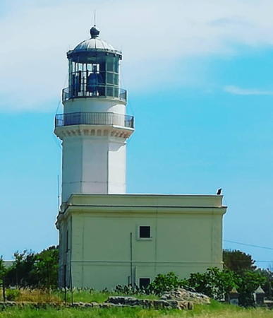
1873. Active; focal plane 40 m (131 ft); white flash every 5 s. 22 m (72 ft) octagonal cylindrical masonry tower with lantern and gallery, attached to a 2-story masonry keeper's house. Entire lighthouse painted white; lantern dome is gray metallic. A 2021 photo is at the top of this page, Trabas has an excellent photo by Capt. Peter, Andreas Cramer has a 2021 photo, Gianfranco Guerra has a photo, and Google has a street view and a satellite view. Easily accessible, this is one of the most commonly visited lighthouses of Calabria's east coast. Located on the point of the cape, at the end of the SP 49 highway about 11 km (7 mi) southeast of Crotone. Site open, tower closed. ARLHS ITA-010; EF-3404; Admiralty E2118; NGA 10600.

Punta Alice Light, Cirò Marina
photo copyright Capt. Peter Mosselberger; used by permission
* Capo Rizzuto (2?)
1906. Active; focal plane 37 m (121 ft); two long (2 s) flashes every 10 s, white or red depending on direction. 17 m (56 ft) octagonal cylindrical tower with lantern and gallery, attached to a keeper's house. Entire lighthouse painted white; lantern dome is gray metallic. Trabas has a good photo by Eckhard Meyer, Artem Khvastunov has a 2019 photo, Giuseppe Mantisi has a 2022 closeup, a distant view is available, and Google has a street view and a satellite view. Several sources mention a lighthouse at a lower elevation here during the 19th century; more information is needed on this. Capo Rizzuto is only 25 km (15 mi) southwest of Capo Colonne but it seems to be visited much less often. Located atop a sharp promontory at the end of the Via Faro in the town of Capo Rizzuto. Site open, tower closed. ARLHS ITA-033; EF-3396; Admiralty E2112; NGA 10596.

Reggio di Calabria Province: Ionian Sea Lighthouses
* Punta Stilo (Monasterace)
1887. Active; focal plane 54 m (177 ft); three white flashes every 15 s. 16 m (52 ft) octagonal masonry tower with lantern and double gallery, painted with narrow black and white horizontal bands. Trabas has a fine closeup photo by Capt. Peter, Gianpiero Taverniti has a 2021 photo, a 2008 photo is available, Wikimedia has two photos, and Google has a street view and a satellite view. Located on a hilltop above the E90 coastal highway at Monasterace. Site open, tower closed. . ARLHS ITA-147; EF-3388; Admiralty E2108; NGA 10584.
* Siderno Marina
Date unknown. Active (privately maintained); focal plane 13 m (43 ft); continuous red (upper) and green lights mounted on a mast on a pierhead building. Trabas has Capt. Peter's photo and Google has a street view and a satellite view. Located at the end of the 300 m (1000 ft) pier at Siderno. Accessible by walking the pier. Site open, tower closed. Admiralty E2109; NGA 10588.
* Capo Spartivento Calabro
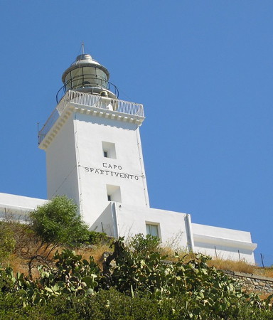
1867. Active; focal plane 63 m (207 ft); white flash every 8 s. 16 m (52 ft) square cylindrical masonry tower with lantern and gallery, rising from a 1-story keeper's house. Entire lighthouse painted white; lantern dome is gray metallic. Luca Galli's photo is at right, Trabas has a photo, Angelo Ghelardi has a closeup photo, and Google has a street view and satellite view. This famous lighthouse is the southernmost lighthouse of the Italian mainland. Note that there is another Capo Spartivento, with another famous lighthouse, at the southern tip of Sardinia. Located above the E90 coastal highway in Brancaleone, about 1.2 km (3/4 mi) southwest of Gelati. Site open, tower closed. ARLHS ITA-043; EF-3384; Admiralty E1782; NGA 10580.
Capo Spartivento Light
Capo Spartivento Light, Brancaleone, August 2014
Wikimedia Creative Commons photo by Luca Galli

Reggio di Calabria Province: Strait of Messina Lighthouses
Only 4 km (2.5 mi) wide at its northern end, the famous Strait of Messina separates Calabria from the island of Sicily. A natural whirlpool develops at the northern entrance to the strait, making this passage a dangerous one. In legend, this was the home of Scylla and Charybdis, sea monsters who dwelled on either side of the narrow passage, Scylla on the Calabrian side and Charybdis on the Sicilian, drowning sailors who passed too close to one or the other. There has been a long-running controversy in Italy about building a bridge across the strait, which is technically feasible but would be very expensive. In October 2006 parliament voted narrowly to shelve plans for the bridge. The project was revived in 2009, cancelled again in 2013, and revived again in 2023.

Capo dell'Armi
1867. Active; focal plane 95 m (312 ft); two white flashes every 10 s. 12 m (39 ft) octagonal cylindrical masonry tower with lantern and gallery, rising from a 2-story masonry keeper's house. Entire lighthouse painted white; lantern dome is gray metallic. A photo is at right, Trabas has an excellent closeup photo, and Google has a street view and a satellite view. This lighthouse serves as a landfall light for ships approaching the Strait from the south. Note: there is also a Faro di Capo dell'Arma located near the French border in Liguria. Located above the E90 coastal highway at the extreme southwestern tip of the Calabrian peninsula. Accessible by a one-lane access road. Site and tower closed although the lighthouse can be seen from nearby. ARLHS ITA-014; EF-3380; Admiralty E1780; NGA 9744.
Reggio Calabria Molo de Ponente
Date unknown (station established 1883). Active; focal plane 14 m (46 ft); green light, 1 s on, 1 s off. 10 m (33 ft) two-stage tower, painted green; the lower half is a round conical concrete tower with gallery, and the upper stage is a typical Italian "bottle" pier light: a post mounted on a round cylinder. Entire lighthouse painted green. Trabas has a closeup photo by Capt. Peter, another closeup is available, Vasiliy Kholopov has a street view showing both mole lights, and Google has a satellite view. Located on the end of the breakwater at Reggio Calabria. Site status unknown but there's a good view from ferries crossing the Strait of Messina to Messina, Sicily. Site open, tower closed. EF-2728; Admiralty E1776; NGA 9736.
* Reggio Calabria Molo de Sottoflutto
Date unknown (station established 1883). Active; focal plane 11 m (43 ft); red flash every 3 s. 9 m (30 ft) "bottle" pier light: a post mounted on a round cylinder, mounted on a 1-story concrete pierhead building. Lighthouse painted red. Trabas has a closeup photo by Capt. Peter, Lubo Trifonov has a photo, Vasiliy Kholopov has a street view showing both mole lights, and Google has a satellite view. Located on the end of the breakwater at Reggio Calabria. The light appears to be accessible by walking the pier. Site open, tower closed. EF-2732; Admiralty E1777; NGA 9740.
Capo dell'Armi Light
Capo dell'Armi Light, Motta San Giovanni, June 2010
Wikimedia Creative Commons photo by Cirimbillo
* Villa San Giovanni (Molo de Ponente)
Date unknown (station established 1911). Active; focal plane 14 m (46 ft); green flash every 3 s. 10 m (33 ft) two-stage tower, painted green; the lower half is a round conical concrete tower with gallery, and the upper stage is a typical Italian "bottle" pier light: a post mounted on a round cylinder. Entire lighthouse painted green. Trabas has Capt. Peter's closeup photo and Google has a satellite view. Located on the end of the breakwater at Villa San Giovanni. Accessible by walking the mole, and there's also a good view from ferries crossing the Strait of Messina to Messina, Sicily. Site open, tower closed. ARLHS ITA-260; EF-2724; Admiralty E1772; NGA 9724.
* Punta Pezzo (4)
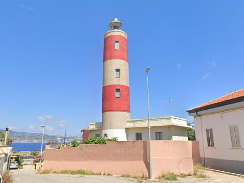
1953 (station established 1883) . Active; focal plane 26 m (85 ft); three red flashes every 15 s. 23 m (75 ft) cylindrical concrete tower with lantern but no gallery, painted with red and white horizontal bands. Google's 2022 street view is at right, Trabas has Capt. Peter's closeup photo, Daniele Casarola has a 2021 photo, Wikimedia has Jacopo Werther's 2009 view from the strait and a 2010 view by Dennis Jarvis, and Google has a satellite view. The original lighthouse, an 18 m (59 ft) octagonal stone tower, was probably destroyed by the great Messina earthquake of 1908. It was replaced by much smaller lights. The present lighthouse was built in connection with the construction in 1957 of an overhead powerline crossing the Strait. A second lantern, mounted on the front of the tower, showed a yellow light when the Strait was closed to navigation due to construction or repairs to the line. The overhead powerline was replaced by a submarine cable in the late 1990s, so this signal is no longer required. Located at the narrowest point of the Strait, on the Via Faro in Villa San Giovanni. Site open, tower closed. ARLHS ITA-139; EF-2720; Admiralty E1770; NGA 9720.

Punta Pezzo Light, Villa San Giovanni, June 2022
Google Maps street view

Reggio di Calabria Province: Tyrrhenian Sea Lighthouses
* Scilla (Castello di Scilla) (3)
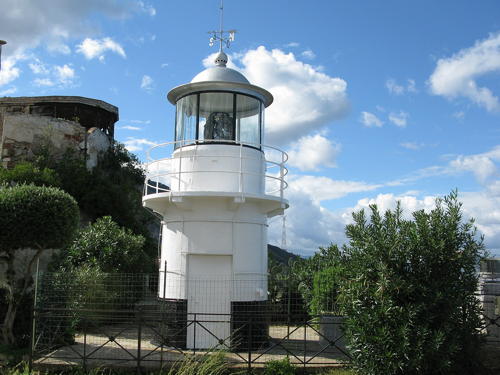
Date unknown (station established 1913). Active; focal plane 72 m (236 ft); white flash every 5 s. 6 m (20 ft) round cylindrical tower with lantern and gallery. Lighthouse painted white with a black band at the base; lantern dome is gray metallic. Wikimedia has Jacopo Werther's photo (seen at right), Trabas has Capt. Peter's closeup photo, Turi Galbraith has a 2023 closeup photo, Jörg Haubner has a 2019 sunset photo, Daniël de Wit has a 2018 street view, and Google has a satellite view. This lighthouse serves as a landfall light for ships approaching the Strait from the north. The lighthouse is actually built on a terrace on the seaward side of the 13th century Castello Ruffo di Scilla. Located on a steep promontory on the east side of the northern entrance to the Strait of Messina. Site open, tower closed. . ARLHS ITA-050; EF-2712; Admiralty E1766; NGA 9708.
Gioia Tauro South Breakwater
Date unknown. Active (privately maintained); focal plane 14 m (46 ft); green flash every 4 s. 10 m (33 ft) round cylindrical concrete tower, painted green. Trabas has Eckhard Meyer's closeup photo and Google has a satellite view. Strategically located at the toe of the Italian peninsula, Gioia Tauro is the busiest Italian container port and one of the largest container terminals in Europe. Located at the end of the south breakwater of Gioia Tauro. Site status unknown. EF-2710; Admiralty E1763.2; NGA 9704.7.
* Gioia Tauro (Directional Light 1)
Date unknown. Active (privately maintained); focal plane 22 m (72 ft); continuous white, red or green light, depending on direction. Approx. 18 m (59 ft) square skeletal tower with gallery, painted white. Trabas has Capt. Peter's closeup photo and Google has a street view (through a fence) and a satellite view. The light tower stands in front of the harbor control building opposite the port entrance. Site open, tower closed. Admiralty E1763.35; NGA 9704.6.

Scilla Light , Scilla, October 2014
Wikimedia Creative Commons photo by Jacopo Werther
Gioia Tauro North Breakwater
Date unknown. Active (privately maintained); focal plane 14 m (46 ft); red flash every 4 s. 10 m (33 ft) round cylindrical concrete tower, painted red. Trabas has Eckhard Meyer's photo and Google has a satellite view. Located at the end of the north breakwater of Gioia Tauro. Site status unknown.EF-2709; Admiralty E1763; NGA 9704.5.

Vibo Valentia Province Lighthouses
* Capo Vaticano
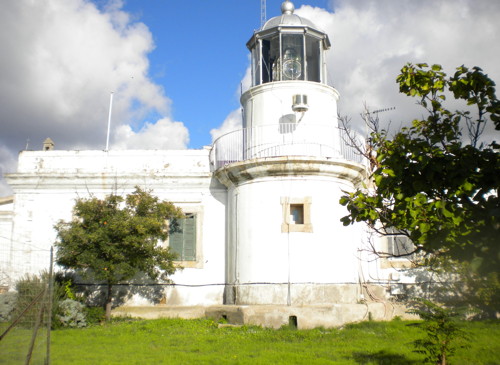
1885. Active; focal plane 108 m (354 ft); four white flashes every 20 s. 8 m (26 ft) round cylindrical masonry tower with lantern and gallery, attached to the front of a 1-story masonry keeper's house. Entire lighthouse painted white; lantern dome is gray metallic. 2nd order Fresnel lens in use. A photo is at right, Trabas has a closeup photo by Capt. Peter showing the results of recent restoration work, a 2008 closeup is available, and Google has a street view and a satellite view. The lighthouse was actually completed in 1870 but not activated until 15 years later. Capo Vaticano--the knuckle on Italy's toe--is a prominent cape separating the Golfo di Sant'Eufemia to the north from the Golfo di Gioia to the south. Located in Ricadi atop a steep promontory at the westernmost point of the cape. Site and tower closed, although the lighthouse can be viewed from nearby points. ARLHS ITA-047; EF-2708; Admiralty E1762; NGA 9704.
* Vibo Valentia Marina (Porto Santa Venere, Caleta Buccarelli) (North Mole) (3)
Date unknown (station established 1884). Active; focal plane 17 m (56 ft); flash every 5 s, white or green depending on direction. 15 m (49 ft) round tapered concrete tower with lantern and gallery, painted green. Trabas has a photo by Capt. Peter, Barbu Constantin has a closeup 2023 photo, and Google has a satellite view. The town is the port for the province of Vibo Valentia; its name was changed from Porto Santa Venere to Vibo Valentia Marina in 1928. Located at the end of the breakwater mole of Vibo Valentia Marina, at the south end of the Golfo di Sant'Eufemia. Accessible by walking the mole. Site open, tower closed. ARLHS ITA-300; EF-2697; Admiralty E1757; NGA 9692.
Capo Vaticano Light
Capo Vaticano Light, Ricadi, 2010
Wikimedia Creative Commons photo by Schnäggli

Catanzaro Province Lighthouses
* Capo Suvero (1 and 2)
1984 (station established 1869). Active; focal plane 58 m (190 ft); two white flashes every 10 s. 25 m (82 ft) square cylindrical masonry tower with lantern and gallery, attached to a 2-story masonry keeper's house. Entire lighthouse painted white; lantern dome is gray metallic. Trabas has a closeup photo by Capt. Peter, Gaspare Guzzo Foliaro has a 2020 photo, a 2008 photo is available, Wikimedia has Fiorenzo Fiorenza's photo, Marinas.com has aerial photos, and Google has a street view and a satellite view. The original light was an octagonal tower centered on the keeper's house, and the first story of this tower is still in place. Located on the cape, at the northern entrance to the Golfo di Sant'Eufemia about 2 km (1.2 mi) south of Marina di Gizzeria. Site status unknown, but the lighthouse can be viewed from nearby. . ARLHS ITA-045; EF-2692; Admiralty E1756; NGA 9684.

Cosenza Province: Tyrrhenian Sea Lighthouses
Cosenza spans the upper end of the "foot" of Italy; it also has a east coast on the Gulf of Taranto. Lighthouses of that coast are listed near the top of this page.
* Paola (Torre del Soffio) (2)
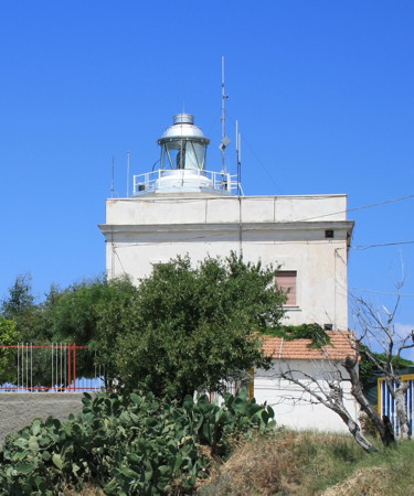
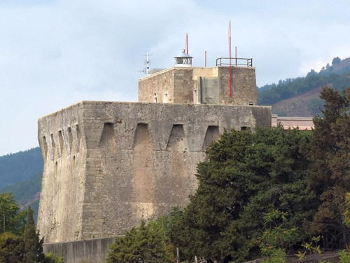
1939 (?) (station established 1929). Active; focal plane 53 m (174 ft); three white flashes every 15 s. 17 m (56 ft) massive square stone defensive and watch tower with a round lantern mounted at the highest level. The tower is unpainted; lantern painted white with a gray metallic dome. Wikimedia has Fiorenzo Fiorenza's photo seen at right, Trabas has a photo by Capt. Peter, Giovanni Solone has a photo, and Google has a street view and a satellite view. The 16th century Torre del Soffio is a landmark and tourist attraction in Paola. According to one source, the light was "modernized" (replaced?) in 1939. Located two blocks from the sea above the waterfront of Paola. Site open, tower status unknown. ARLHS ITA-111; EF-2688; Admiralty E1752; NGA 9680.
Capo Bonifati
Date unknown. Active; focal plane 63 m (207 ft); two white flashes every 10 s. 7 m (23 ft) square skeletal tower, painted white, adjoining a 1-story equipment building. Trabas has Capt. Peter's closeup photo, a 2023 photo is available, Wikimedia has Fiorenzo Fiorenza's photo, and Google has a street view and a satellite view. Located off the Via Santa Maria between Lampezia and Bonifati. It appears possible to climb the hill to the lighthouse, but no parking is available. Site open, tower closed. ARLHS ITA-016; EF-2684; Admiralty E1750; NGA 9676.
* Scalea
1922. Inactive since 1981. Approx. 13 m (43 ft) square cylindrical castellated stone tower attached to a 1-story stone keeper's house. Lantern removed. Tower painted red with white trim. Adam Graczek has a 2018 photo and Google has a street view and a satellite view. Huelse has a historic postcard view from the 1930s and a second postcard view from the 1960s showing a more modern lantern. Located on a steep bluff on the Via Faro at the north end of Scalea, a tourist-oriented town near the northern border of Calabria. Site and tower closed (private property), but the tower can be seen from the street.

Information available on lost lighthouses:

Notable faux lighthouses:


Torre del Soffio Light, Paola, September 2017
Wikimedia Creative Commons photo by Fiorenzo Fiorenza

Adjoining pages: North: Campania and Lazio | East: Southern Puglia | West: Eastern Sicily

Return to the Lighthouse Directory index | Ratings key

Posted June 16, 2006. Checked and revised February 7, 2024. Lighthouses: 29. Site copyright 2024 Russ Rowlett and the University of North Carolina at Chapel Hill.