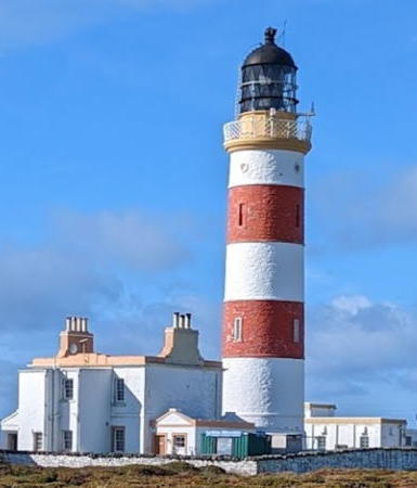
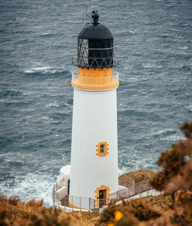
- * [Derby Fort]
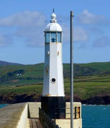
- Late 1700s. Inactive since the late 1800s. This light was mounted on Derby Fort, a round tower built in 1645. Ruins of the tower survive. According to Findlay's 1879 list the light had a focal plane of 50 ft (15 m). Julie Corteen has a 2022 photo, Wikimedia has Richard Hoare's photo and another photo by Chris Gunns, and Google has a satellite view and a distant street view. Located on St. Michael's Isle, a small island off the northern tip of the Langness Peninsula east of Derbyhaven. The island is attached to the mainland by a causeway. Site open.
- * [Langness
Herring Tower]
- 1811 (Thomas Brine). Daybeacon, never lit. Approx. 18 m (60 ft) cylindrical,
castellated stone tower, unpainted. James Qualtrough has a photo, Zofia Kuchta has a 2018 photo, and Google has a satellite view and a street view at the base of the tower. This tower
and an identical tower at Douglas Head were built specifically as daybeacons. The towers are copies of a round
tower at Peel Castle. Located about 200 m (220 yd) behind Langness Light
(next entry). Site open, tower closed. Owner/site manager: unknown.
 . .
- * Langness
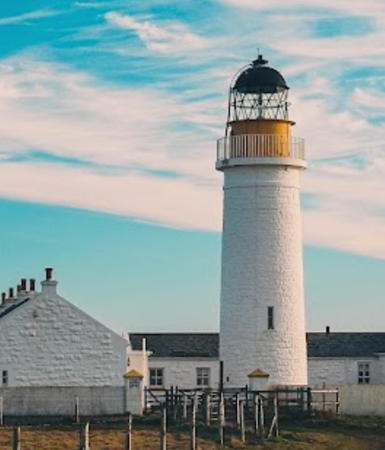
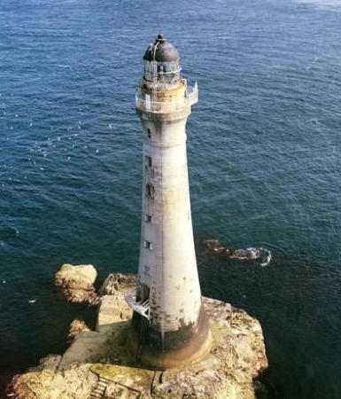
- 1880 (David and Thomas Stevenson). Active; focal plane 21 m (69 ft); two
white flashes, separated by 5.1 s, every 30 s. 19 m (63 ft) round masonry tower
with lantern and gallery. Tower painted white, watch room buff, lantern
black. Twin 300 mm lens, one mounted above the other. 1-story keeper's houses
and other buildings enclosed by a stone wall. Fog signal building with intact
horn (fog signal discontinued in 1987). Callum Qualtrough posted the 2021 photo at the top of this page, Grant Matthews has a good photo, Lighthouse Accommodations has a page for the light station, Trabas has Fox'z 2001 photo, Huelse has a historic postcard view, and Google has a satellite
view. Langness ("Long Point") is a slender
peninsula hanging from the southeastern corner of the Isle of Man. For a number of years British
TV personality Jeremy Clarkson owned much of the surrounding land and
attempted to close access to the lighthouse, but in May 2010 he was ordered
to reopen traditional pathways leading to the light. In 2014 the keeper's cottages were renovated and opened for overnight accommodations. Located on the east
side of Dreswick Point, the southern point of the peninsula, about 2.5 km
(1.5 mi) south of Derbyhaven. Site open, tower closed. Operator: Northern
Lighthouse Board. Site manager: Langness Lighthouse Cottages
  . ARLHS IOM-009; Admiralty A4762; NGA 4984. . ARLHS IOM-009; Admiralty A4762; NGA 4984.
- * King William's College
- Date unknown. Active; focal plane unknown; continuous red light. Approx. 25 m (82 ft) mast atop a square Gothic stone tower. Trabas has Fox's 2008 photo, Edward Harris has a street view, and Google has a satellite view. This is also a warning light for planes landing at the adjacent Isle of Man Airport. Located on heights at the head of Castletown Bay. Site open, tower closed. Owner/site manager: King William's College. Admiralty A4761.2.
- * Castletown Irish
Quay
- 1944. Active; focal plane 5 m (16 ft); red light, 3 s on,
1 s off. Approx. 3.5 m (12 ft) round masonry tower with a domed top; the
light is shown through a window. Lighthouse painted white with a
single horizontal red band. Dave Abreu has a photo of
both Castletown lights, Trabas has Fox's closeup 2002 photo,
Clinton Hall has a closeup street view, Huelse has a historic postcard view, and Google has a satellite view and a street view of the two Castletown lights. Located at the end of Irish Quay in Castletown;
accessible by walking the quay. Site open, tower closed. Operator: Isle
of Man Harbours. ARLHS IOM-017; Admiralty A4761; NGA 4976.
- * Castletown
New Pier (2?)
- 1849 (station established 1765). Active; focal plane 8 m (26 ft); red light, 13 s on, 2 s
off. Approx. 7 m (23 ft) round cylindrical stone tower with a domed top;
the light is shown through a window. Lighthouse painted white with
a single horizontal red band. Paul Dyer has a dramatic photo,
Gary Fisher has a 2023 photo, Dave Abreu has a photo of
both Castletown lights, Trabas has Fox's closeup photo,
Julian Mason has a closeup street view, and Google has a satellite
view and a street view of the two Castletown lights. Located at the end of the pier in Castletown;
accessible by walking the pier. Site open, tower closed. Operator: Isle
of Man Harbours. ARLHS IOM-002; Admiralty A4760; NGA 4972.
- The Carrick
- Date unknown. Active; focal plane 6 m (20 ft); two quick white flashes every 5 s. 8 m (26 ft) octagonal pyramidal skeletal tower. Trabas has Fox's 2013 photo and Google has a distant satellite view. Located in Ny Carrickey Bay off Port St. Mary. Accessible only by boat. Site open, tower closed. ARLHS IOM-028; Admiralty A4752; NGA 4960.
- * Port
St. Mary Inner Pierhead (2)
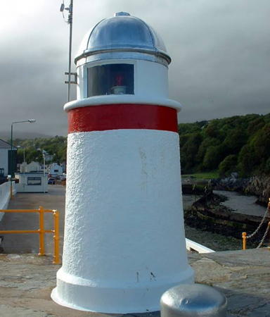
- 1897 (station established 1812). Active; focal plane 8 m (26 ft); red light, 2 s on,
1 s off. 7 m (23 ft) octagonal cylindrical masonry tower with a domed,
enclosed top, painted white with a single narrow horizontal red band.
Part of a 2021 street view is seen above right, Bruno Ricci has a 2022 photo, Trabas has Fox's 2001 photo, and Google has a street view and a satellite
view. Located at the end of the inner pier of Port St. Mary;
accessible by walking the pier. Site open, tower closed. Operator: Isle
of Man Harbours. ARLHS IOM-023; Admiralty A4756; NGA 4964.
- Alfred
Pier (4)
- 2018 (station established 1884). Active; focal plane 7.5 m (25 ft); red light occulting once every 8 s. 7 m (23 ft) round fiberglass tower colored white with one red horizontal band. Trabas has Fred Fox's 2017 photo seen at right. This light is a replacement for the 1943 light, a 7 m (23 ft) hexagonal cast iron
tower with lantern.
An unusually high tide and a strong wind combined to wash
that lighthouse into the sea during the night of 11-12 January 2009.
Marinas.com has aerial views of the lost light. Lighthouse Accommodations has a photo of the new light (fourth photo on the page) and Google has an indistinct satellite
view. Located at the end of the outer pier of Port St. Mary.
Site open, tower closed. Operator: Isle
of Man Harbours. ARLHS IOM-026; Admiralty A4754; NGA 4968.
|
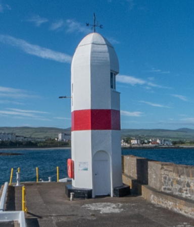
Inner Pierhead Light, Port St. Mary, June 2022
ex- Google Maps photo by permission
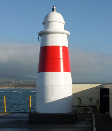
Alfred Pier Light, Port St. Mary, November 2017
photo copyright Fred
Fox; used by permission
|
