Lighthouses of the United Kingdom: Northern Ireland

The smaller of the two main British Isles, the island of Ireland is separated from Great Britain to its east by the North Channel, the Irish Sea, and St George's Channel. Ireland came under English rule in the 16th and 17th centuries and in 1801 the United Kingdom of Great Britain and Ireland was formally established. Following decades of struggle most of Ireland became independent in 1922. The northern portion remained in the United Kingdom, forming the present United Kingdom of Great Britain and Northern Ireland.

Northern Ireland is governed as an autonomous region within the United Kingdom. Most of its coast faces Scotland across the North Channel. Belfast is the capital and largest city; Londonderry (Derry) and Belfast are the major ports.

Historically Ireland was divided into 32 counties and Northern Ireland includes six of them. The six northern counties no longer have any local government function although they have great cultural recognition; instead the region is divided into eleven local government districts.

The division of Ireland did not change the administration of the coastal Irish lighthouses. The Commissioners of Irish Lights, a corporation chartered by the Irish Parliament in 1786 and based in Dublin, continues to operate the major coastal lighthouses in both Northern Ireland and the Irish Republic. Harbor lights are operated by the local harbor authorities.

The Irish language is spoken commonly as a first or second language in Ireland. The Irish phrase for a lighthouse is teach solais (plural tithe solais). Oileán (plural oileáin) is an island, cuan is a bay, inbhear is an estuary, rinn is a cape, and chuain is a harbor. A lough (pronounced like the Scottish loch) is a lake or an inlet of the sea.

ARLHS numbers are from the ARLHS World List of Lights. CIL numbers are from the light list of the Commissioners of Irish Lights. Admiralty numbers are from Volume A of the Admiralty List of Lights & Fog Signals. U.S. NGA numbers are from Publication 114.

General Sources
Commissioners of Irish Lights - Our Lighthouses
An interactive map leads to pages for each of the CIL lighthouses.
Pete's Irish Lighthouses
Peter Goulding's informative blog on the lighthouses of Ireland. There are pages for County Derry, County Antrim and County Down.
Great Lighthouses of Ireland
This website provides information on twelve Irish lighthouses CIL has identified for tourism development. Three are in Northern Ireland (Rathlin West, Blackhead Antrim, and St. John's Point).
Online List of Lights - Northern Ireland
Photos by various photographers posted by Alexander Trabas.
Lighthouses in Northern Ireland
Photos available from Wikimedia; many of these photos were first posted on Geograph.org.uk.
World of Lighthouses - Northern Ireland
Photos by various photographers available from Lightphotos.net.
United Kingdom Lighthouses
Aerial photos posted by Marinas.com.
Britische Leuchttürme auf historischen Postkarten
Historic postcard images posted by Klaus Huelse.
GPSNavigationCharts
Navigation chart information for Northern Ireland.
Navionics Charts
Navigation chart for Northern Ireland.


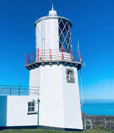
Blackhead Light, County Antrim, June 2023
Instagram photo by Oleg Promakhov


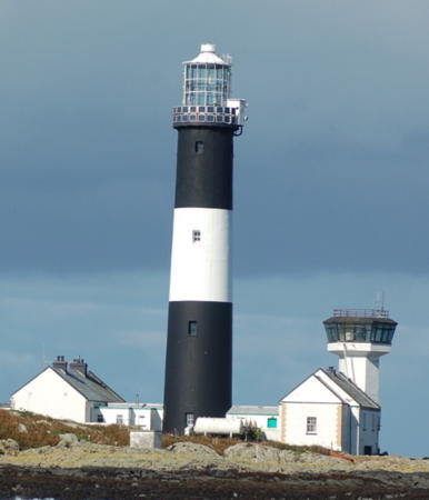
East Maidens Light, North Channel, June 2008
Flickr Creative Commons photo by David Maxwell

County Londonderry (Derry) Lighthouses

Derry City and Strabane District (River Foyle) Lighthouses
The city of Derry (officially Londonderry) is the second largest city of Northern Ireland with an urban area population of about 100,000. The city is located on the River Foyle upsteam from Lough Foyle, a broad inlet that forms its estuary. The lough separates County Donegal in the Republic of Ireland from County Londonderry (Derry) in Northern Ireland. The British government claims that all of Lough Foyle lies within the United Kingdom but this claim is not accepted by the Irish government. In the Belfast Agreement of 1998 the two governments agreed to continue disagreeing about the exact location of the boundary; instead of resolving it they established the intergovernmental Loughs Agency to administer the waters of Lough Foyle as well as Carlingford Lough, which forms their border on the east side of Ireland. Several lighthouses of Lough Foyle are described on the Western Ireland page.
* Culmore (3)
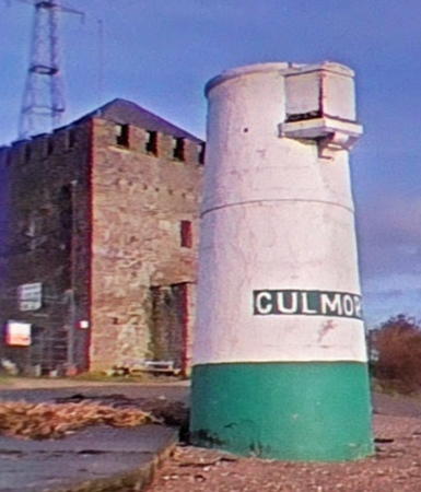
1920s (station established 1848). Inactive since 2012. 7 m (23 ft) concrete tower with a small window near the top through which the light was formerly displayed. Lighthouse painted white with a green base. One of Goulding's photos is at right, John Heaney has a closeup photo, a 2012 closeup photo is available, Huelse has a historic postcard view, Shawn Williams has a street view, and Google has a satellite view. The lighthouse stands at the end of a promontory projecting into the River Foyle just south of its mouth, near Culmore Fort. There is an active light (focal plane 4 m (13 ft); quick-flashing green light) on a nearby post. Site probably open, tower closed. Owner: Foyle Port (Londonderry Port and Harbour Commissioners). ARLHS NTI-028; ex-Admiralty A6132. Active light: Admiralty A6131; NGA 7176.
Ballynagard
Date unknown. Active; focal plane 6 m (20 ft); white flash every 3 s. 7 m (23 ft) concrete tower with a small window near the top through which the light was formerly displayed; the current solar-powered light is mounted on top of the tower. Lighthouse painted white with a green base. Trabas has a closeup photo and Google has a satellite view. Located on the west bank of the River Foyle at Ballynagard, about 1.5 km (1 mi) southwest of the Culmore Light. Site and tower closed (private property). Operator: Foyle Port (Londonderry Port and Harbour Commissioners). Admiralty A6136; NGA 7196.
Otterbank
Date unknown. Active; focal plane 6 m (20 ft); red flash every 4 s. 6 m (20 ft) round concrete tower with a small window near the top through which the light was formerly displayed; the current solar-powered light is mounted on top of the tower. Lighthouse painted white with a red base. Trabas has a photo and Google has a satellite view. Located on the edge of shoals on the east side of the River Foyle channel about 200 m (1/8 mi) south of Ballynagard. Accessible only by boat. Site open, tower closed. Operator: Foyle Port (Londonderry Port and Harbour Commissioners). Admiralty A6138; NGA 7200.
[Brook Hall (Brookhall) (2?)]
Date unknown (station established 1859). Active; focal plane 6 m (20 ft); quick-flashing green light. 6 m (20 ft) light mounted on a concrete pyramid. Trabas has a closeup photo and Google has a satellite view. Located on the west side of the River Foyle below the Brook Hall estate. Accessible only by boat. Site open, tower closed. Operator: Foyle Port (Londonderry Port and Harbour Commissioners). Admiralty A6140; NGA 7208.

Culmore Light, Culmore, August 2016
photo copyright Peter Goulding; used by permission

Coleraine Area (Causeway Coast and Glens District) Lighthouse
Barmouth East Pierhead (River Bann Entrance)
1947. Active; focal plane 6 m (20 ft); red flash every 5 s. 4.5 m (15 ft) square pyramidal concrete tower attached to a small concrete equipment shelter. Entire structure is white. Trabas has a photo and Google has a satellite view. Located at the end of the east breakwater at the entrance to the River Bann. Accessible by walking the pier after a trek through sand to reach the river mouth. Site open, tower closed. Operator: Coleraine Harbour Commissioners. Admiralty A6076; NGA 7060.
* Portstewart Point
Date unknown. Active; focal plane 21 m (69 ft); red light, 7 s on, 3 s off. Light mounted on a 3 m (10 ft) square concrete equipment hut, painted bright red. A mast, also mounted atop the hut, carried pilot signals. Trabas has a photo and Google has a September 2009 street view and a satellite view. The building was repainted from green to red in the fall of 2009. Located on the point, near the end of Harbour Road in Portstewart. Parking provided. Site open, tower closed. Operator: unknown. Operator: Coleraine Harbour Commissioners. ARLHS NTI-038; Admiralty A6073; NGA 7056.

County Antrim Lighthouses

Causeway Coast and Glens District: Causeway Coast Daybeacon
[Storks Reef Beacon]
Date unknown. Inactive daybeacon. 11 m (36 ft) round stone beacon painted black with a red horizontal band. Bing has an indistinct satellite view of the reef. This is clearly a historic beacon and we need information on its history. Located in Bushmills Bay about 2 km (1.25 mi) west of Portballintrae. Accessible only by boat. Site open, tower closed. Owner/site manager: Commissioners of Irish Lights.

Causeway Coast and Glens District: Rathlin Island Lighthouses
Rathlin Island is in the North Channel 8 km (5 mi) off the northern coast of Antrim. The island is shaped like an inverted L with the shorter leg pointed south and the longer one pointed west. The island has a population of about 80 and is accessible by passenger ferry from Ballycastle (several times daily in the summer, three times a week in the winter). No cars are allowed on the island but all three lighthouses can be reached on foot. One further note: the Rathlin O'Birne Light is on a different island in County Donegal, Republic of Ireland.

****
Rathlin West
1917. Active; focal plane 62 m (204 ft); red flash every 5 s. Lantern on a concrete pad built into a notch in a spectacular almost-vertical cliff. Rising behind the lantern is a square cylindrical tower 18 m (60 ft) high, attached at its upper end to a 2-story keeper's house set into another, higher notch. (At this light station, the keepers climbed down to the light.) All buildings are painted white for best contrast against the dark cliff face. The lighthouse is automated but it is maintained by an attendant. A photo is at right, Goulding has a page for the lighthouse, Lighthouse Accommodations has a page for the Rathlin lighthouses, Chris Lindsay has a photo, Donald MacDonald has a view from the sea, Trabas has a distant view, Paul McIlroy has a photo of the keeper's house, Marinas.com has aerial photos, and Google has a satellite view. Ireland's famous "Upside-Down Lighthouse" has one of the world's most spectacular settings. Building the station took three years and £400,000, a huge sum for the time. The Royal Society for the Protection of Birds has a seabird observation platform atop the cliff close to the lighthouse; Google has a street view. In 2013 CIL announced plans to develop the light station with a visitor center. The lighthouse and birding center were closed in 2014 for a £600,000 restoration. Located at the western end of the island. The site is accessible by a single-track road which also serves as a hiking trail 6 km (4 mi) long. During the summer shuttle bus service is available from the ferry dock. Site open; birding center open and lighthouse tours available daily April 1 through September 15 (admission fee). Operator: Commissioners of Irish Lights (Rathlin West Lighthouse). . ARLHS NTI-012; CIL-1420; Admiralty A6064; NGA 7036.

Rathlin West Light, Rathlin Island, March 2023
Instagram photo
by twoguysonetopic
* Rathlin East (Altacarry Head) Low
1856. Inactive since 1894. 8 m (27 ft) cylindrical cast iron lantern, painted white, with a narrow horizontal window through which a continuous white light was displayed. The lantern is placed beside the high light (next entry); Wikimedia has a closeup photo and the lantern can be seen in the aerial photos of Marinas.com. Owner/site manager: Commissioners of Irish Lights. ARLHS NTI-030.
* Rathlin East (Altacarry Head) High
1856. Active; focal plane 74 m (243 ft); four white flashes, separated by 2.3 s, every 20 s. 27 m (88 ft) stone tower with lantern and gallery, painted white with a broad black band just below the gallery. 2-story and 1-story keeper's houses and other buildings enclosed by a stone wall. The station is maintained by an attendant. David Ford's photo is at right, Goulding has a page for the lighthouse, Paul McIlroy has a photo, Zoe Bowyer also has a good photo, Lighthouse Accommodations has a page for the Rathlin lighthouses, Marinas.com has aerial photos, Huelse has a historic postcard view, and Google has a street view and a satellite view. Ships entering the North Channel from the Atlantic must steer between this light and the Mull of Kintyre Light in Scotland. The site is historic for several reasons. In the cliffs below the lighthouse is a cave complex where Robert the Bruce of Scotland took refuge after being defeated by the English in 1306. Also, Marconi made experimental radio transmissions from this site in 1898. Located at the northeastern right-angle point of the island; accessible by hiking trail. Site and tower closed, but the lighthouse can be viewed from outside the wall. Operator: Commissioners of Irish Lights. . ARLHS NTI-011; CIL-1390; Admiralty A6062; NGA 7032.
Rue Point (3)
1921 (station established 1915). Active; focal plane 16 m (52 ft); two white flashes every 5 s. 11 m (35 ft) octagonal cylindrical concrete tower without lantern; light displayed from a short mast. Anne Burgess has a photo, Goulding has a page for the lighthouse, Trabas has a distant view, Marinas.com has aerial photos, and Google has a good satellite view. The first light was destroyed by a storm in 1917, and the light was moved atop the fog signal tower until the present lighthouse was built. Located on the south point of the island; accessible by a hiking trail (90 minutes one way according to Goulding). Site open, tower closed. Operator: Commissioners of Irish Lights. . ARLHS NTI-013; CIL-1400; Admiralty A6060; NGA 7028.
Rathlin East Light
Rathlin East High Light, Rathlin Island, July 2009
Flickr Creative Commons photo
by mdavidford

Mid and East Antrim District
* [Carnlough North Pier]
Date unknown (station established 1897). Active; focal plane about 10 m (33 ft); green flash every 3 s. 6 m (20 ft) round cylindrical concrete tower painted with black and white horizontal bands. Trabas has a closeup photo, Gareth Rowan has a drone view, a photo is available, and Google has a satellite view. There is a similar but smaller tower on the south pier. Located on the north pier at Carnlough, a village in northern County Antrim. Accessible by walking the pier. Site open, tower closed. Admiralty A6043; NGA 7017.
West Maidens
1829. Inactive since 1903. 18 m (60 ft) stone tower attached to a 2-story stone keeper's house. Lantern and gallery removed. Still serving as a daymark, the tower was previously painted red with a white band at the top; only traces of this paint remain. A photo is at right, Lighthouse Accommodations has closeup photos by Patrick Tubby, Wikimedia has a view from the sea, a 2008 distant view is available, and Ronald Surgenor has a sunset photo. The Maidens are a group of small rocky islands and reefs about 20 km (13 mi) northeast of Larne; in Irish they are called Na Faoilinn (The Seagulls). The islands are not shown in Google's satellite view. Located on a tiny island roughly 1 km (0.6 mi) west of the active East Maidens Light. Accessible only by boat. Site and tower closed. Owner/site manager: unknown. ARLHS NTI-024.
Maidens (East Maidens)
1829. Active; focal plane 29 m (95 ft); three white flashes every 15 s. 23 m (76 ft) stone tower with lantern and gallery attached to 2-story stone keeper's houses. Lighthouse painted white with a single black horizontal band. David Maxwell's 2008 photo is at the top of this page, Goulding has a page for the lighthouse, Lighthouse Accommodations has a page for the Maidens lighthouses, another 2008 photo is available, Trabas has Thomas Philipp's view from the sea, and Marinas.com has aerial photos. The lighthouse is located on a tiny island near the east end of the group, guarding the approach to Larne. Accessible only by boat. Site and tower closed. Operator: Commissioners of Irish Lights. ARLHS NTI-023; CIL-1370; Admiralty A6042; NGA 7016.

West Maidens Light, North Channel, July 2018
Twitter photo by @loughpics
* Chaine Tower (Sandy Point)
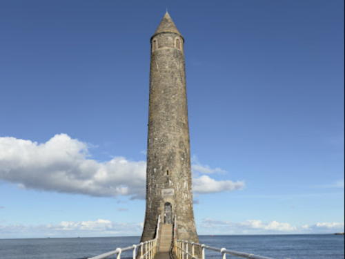
1899 (tower built in 1888). Active; focal plane 23 m (75 ft); light 2.5 s on, 2.5 s off, white or red depending on direction. 23 m (75 ft) stone tower with a conical roof; light shown through a window. The tower is floodlit at night. Anne Burgess's photo is at right, Goulding has a page for the lighthouse, Trabas has a closeup photo, Bernie McAllister has a nighttime photo, Irene Cropper has a 2018 photo, Lighthouse Accommodations has a page for the lighthouse, and Google has a street view and a satellite view. Known locally as The Pencil, this unusual tower was built as a daybeacon by the Larne Harbour Board in 1888. It served as a memorial to James Chaine (1841-1885) a member of Parliament who had worked for harbor improvements at Larne. The Commissioners of Irish Lights assumed ownership in 1899 when a light was installed. From 1905 to 1935 the lighthouse was fueled automatically with coal gas. Located just off Sandy Point on the west side of the entrance to Larne Lough, connected to the mainland by a short causeway. Site open, tower closed. Operator: Larne Harbour, Ltd. . ARLHS NTI-004; Admiralty A6031; NGA 6984.
* Ferris Point (Larne Lough, Ferres Point) (2)
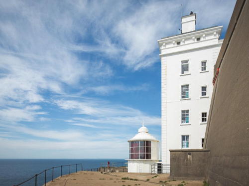
1976 (station established 1839). Inactive since the mid 1990s. Approx. 15 m (50 ft) square cylindrical tower supporting a large square, glass-enclosed control room. Tower painted white; control room appears black from a distance. A 2020 photo and a 2022 closeup are available, Chris Newman has a good view from the lough, Lighthouse Accommodations has a page for the lighthouse, Marinas.com has aerial photos, the tower appears at the far right in the photo of Chaine Tower at right, and Google has a satellite view and a distant street view. This is the harbor control tower for Larne, a major port. The tower replaced a traditional light station and formerly carried a navigational light; the light became redundant when a directional light was installed in the Chaine Tower (previous entry) on the other side of the harbor entrance. Goulding has a good page on the original light and a postcard view is also available. Located at the east side of the narrow entrance to Larne Lough. There are good views from ferries connecting Larne to several ports in Scotland. Site open, tower closed. Owner/operator: Larne Harbour, Ltd. ARLHS NTI-006.
Chaine Tower
Chaine Tower, Larne, May 2007
Geograph Creative Commons photo by Anne Burgess
[Barr Point Fog Signal]
1905. Inactive since 2006. 5 m (17 ft) rectangular 1-story fog signal building, painted white. Google has a satellite view. Located near the 7th green of the Larne Golf Club, about 800 m (1/2 mi) north of Ferris Point on the east side of the entrance to Larne Lough directly opposite the Chaine Tower. Site and building closed. Site manager: Larne Golf Club. ex-Admiralty A6030; ex-NGA 6976.
** Blackhead Antrim
1902 (William Douglass). Active; focal plane 45 m (148 ft); white flash every 3 s. 15.5 m (51 ft) octagonal cylindrical granite tower with lantern and gallery attached by a covered walkway to 2-story keeper's house. Additional keeper's houses and other buildings preserved. Three keeper's houses are available for vacation rental. Oleg Promakhov's drone view appears at the top of this page, Albert Bridge has a closeup, Goulding's page has several photos, Trabas has John Eagle's beautiful photo, a 2010 view from the sea is available, Marinas.com has aerial photos, Huelse has a historic postcard view, Alan Welsh has a street view, and Google has a satellite view. CIL calls this lighthouse Blackhead Antrim because it also maintains the Blackhead Clare Light in County Clare. In January 2010 the Environment Agency announced plans to list the station as a historic site. In 2013 CIL announced plans to designate the lighthouse as one of the Great Lighthouses of Ireland and to develop the light station. Located atop a spectacular vertical cliff on a sharp headland at the northern entrance to Belfast Lough. Accessible by road off the B150 highway about 4 km (2.5 mi) north of White Head. Site open, tower closed. Operator: Commissioners of Irish Lights (Blackhead Antrim Lighthouse). Site manager (keepers houses): Irish Landmark Trust. . ARLHS NTI-003; CIL-1280; Admiralty A6028; NGA 6972.

Belfast City Lightbeacon
** [Mew Island Lens ("The Great Light")]
1887. A decorative light is displayed. This original F. Barbier hyper-radiant Fresnel lens was first installed at Tory Island in 1887; it was re-installed at Mew Island in 1928. In 2015 Irish Lights offered the giant lens to the Titanic Foundation in Belfast and negotiations began on how it could be displayed. The lens was removed in November 2015. The Titanic Museum in Belfast applied to the Heritage Lottery Fund for funds to restore the lens and it went on display starting in March 2018 in a special structure on the Belfast waterfront. William Murphy's photo is at right, Paul O'Hara has a 2018 closeup photo, and Google has a satellite view. The lens is shrouded during the day to protect the lens, so it is best viewed in the evening. Located in the Titanic Quarter. Site open. .

Mew Island Lens, Belfast, March 2019
Flickr Creative Commons photo
by William Murphy

County Down Lighthouses

Ards and North Down District Lighthouses
* [Bangor North Pier]
Date unknown (station established 1896). Active; focal plane 9 m (30 ft) (?); red light, 6 s on, 6 s off. 11 m (36 ft) round red concrete pillar. Trabas has a closeup photo, Joseph Abranyi has a 2018 photo, Mike Yeaman has a photo, Yan Miro has a street view, Lighthouse Accommodations has a page for the light, and Google has a satellite view. Next to the light is a mosaic mural honoring those who died in the D-Day invasion of Normandy in 1944. Bangor is a town of about 60,000 residents at the south entrance to Belfast Lough. Now known as the Eisenhower Pier, the Bangor North Pier is a broad breakwater sheltering the harbor and providing a popular viewpoint. The listed focal plane for the light seems too low. Located at the end of the pier. Site open, tower closed. Operator: Bangor Marina. Admiralty A5980; NGA 6794.
Mew Island
1884. Active; focal plane 37 m (121 ft); four white flashes, separated by 5 s, every 30 s. 37.5 m (123 ft) stucco-covered rubblestone tower with lantern and gallery, painted with black and white horizontal bands. Rubblestone keeper's houses and other buildings. The great hyper-radiant Fresnel lens installed in 1928 was removed in 2014 and is on display in Belfast (see above). A 2021 closeup photo is at right, Trabas has Rainer Arndt's photo, a 2007 photo is available, John Grant has a November 2008 photo, Goulding's page has distant views, Lighthouse Accommodations has a page for the lighthouse, Marinas.com has aerial photos, and Bing has a satellite view of the station. This lighthouse, which replaced a lower tower on nearby Lesser Copeland Island, marks the beginning of the approach to Belfast for ships coming from the south and east. There were onshore keeper's houses at Donaghadee. Located on Mew Island, a small island about 10 km (6 mi) north of Donaghadee. Accessible only by boat. Site and tower closed. Operator: Commissioners of Irish Lights. . ARLHS NTI-009; CIL-1260; Admiralty A5976; NGA 6792.
* [Copeland Island (Lighthouse Island) (2)]
1815 (station established early 1700s). Inactive since 1884. 5 m (17 ft) stump of a 16 m (52 ft) stone tower, with the ruins of the keeper's house and a modern house built as a bird observatory. A closeup photo is available and Google has a satellite view of the station. The lighthouse was abandoned in favor of the Mew Island Light to the north. The island is now owned by the National Trust and managed by the Royal Society for the Preservation of Birds. Overnight accommodations are available. Located on Lesser Copeland Island, also called Lighthouse Island, an island just southwest of Mew Island and about 7 km (4 mi) north of Donaghadee. Accessible only by boat. Site open, tower closed. Owner: National Trust Northern Ireland. Site manager: Copeland Bird Observatory. ARLHS NTI-031.
 

Mew Island Light, North Channel, July 2021
Geograph Creative Commons photo by Rossographer
 
* Donaghadee
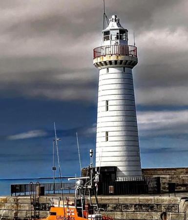
1836. Active; focal plane 17 m (56 ft); white light, 2 s on, 2 s off; red light is shown over shallow water along the shore to the southeast. 16 m (53 ft) limestone tower with lantern and gallery, painted white. Fog siren (blast every 12 s) sounds only when ships are expected. A photo is at right, Trabas has a photo, Matthew Johnston has a lovely photo of a rainbow over the lighthouse, Goulding's page has a good photo, a 2021 closeup photo and a good 2008 photo are available, Lighthouse Accommodations has a page for the lighthouse, Marinas.com has aerial photos, Huelse has a historic postcard view, and Google has a street view and a satellite view. The lighthouse was repaired after being heavily damaged by fire on 12 May 1900. In October 1934 the light was the first in Ireland to be converted to electric power. Located at the end of the South Pier at Donaghadee, 15 km (9 mi) east of Bangor. Accessible by walking the pier. Site open, tower closed. Operator: Commissioners of Irish Lights. . ARLHS NTI-005; CIL-1210; Admiralty A5974; NGA 6788.
South Rock (Kilwarlin)
1797 (Thomas Rogers). Inactive since 1877. 18 m (60 ft) round granite tower with gallery; no lantern. A 2017 photo is available, a 2007 photo also shows the South Rock lightship, Michael Parry has a distant view, Lighthouse Accommodations has a page for the lighthouse, and Bing has a satellite view. This is the oldest surviving waveswept lighthouse in Ireland and surely one of the oldest in the world. It was originally called the Kilwarlin light after its chief patron, Lord Kilwarlin. It remains on the CIL list as the South Rock Beacon. The light was replaced by the South Rock Lightship in 1877. The lantern was stolen by well-equipped thieves in 1972. In 2009 the South Rock lightship was withdrawn and replaced by a large superbuoy. Located off Portavogie and about 5 km (3 mi) northeast of Kearney. Accessible only by boat. Site and tower closed. Owner: Commissioners of Irish Lights. ARLHS NTI-026; CIL-1150.
* [Newcastle Shore Station]
1820. Closed 1905. Four keeper's houses, three built in 1820 and the fourth in 1863. No photo available. These cottages housed families of keepers of the offshore South Rock Light. After the lighthouse was deactivated in 1877, they housed off-duty crew members of the South Rock Lightship. The houses survive in private ownership. Located in Newcastle, north of Kearney on the Ards Peninsula. Owner/site manager: private.
Donaghadee Light
Donaghadee Light, Donaghadee, April 2010
Geograph Creative Commons photo by Rossographer
[Pladdy Lug (4?)]
1926 (station established at least by 1782). Unlit daybeacon. 10 m (33 ft) octagonal cylindrical stone tower with a stepped pyramidal top, faced with white-glazed brick. Eric Jones has a photo, and the Portaferry Lifeboat station has a photo (halfway down the page) showing a yacht wrecked next to the beacon in 2003. A stock photo is also available and Bing has a satellite view. The reef was originally marked by a perch (post). A stone beacon built in 1875 washed away in 1884 and was replaced with another perch. The present tower was built after that perch was washed away by a storm in 1925. Located at the western end of a dangerous reef extending from Ballyquinton Point on the east side of the entrance to Strangford Lough. Accessible only by boat. Site open, tower closed. CIL-1110.
* Lightship Petrel (Ballydorn)
1915. Decommissioned 1968. 34 m (111 ft) single-masted steel lightship; the light was shown from a large lantern atop the mainmast. Entire ship painted red. Albert Bridge's 2008 photo is at right, Brian Shaw has a photo, Goulding's page has two photos, Marinas.com has aerial photos, and Google has a street view and a satellite view. Built at the Dublin Dockyard, the ship served on numerous stations in Irish waters; her last station was off the River Blackwater, Wexford. After decommissioning, the ship was first sold to Hammond Lane Foundries, which then resold her to the Down Cruising Club at a nominal profit. The ship has been the club's headquarters since 1969. In 2014 it was registered as a historic vessel. Berthed near Ballydorn, northeast of Killinchy, on the west side of Strangford Lough. Site open, vessel open only to club members and guests. Owner/site manager: Down Cruising Club . ARLHS NTI-010.

Lightship Petrel, Ballydorn, February 2008
Geograph Creative Commons photo by Albert Bridge

Newry, Mourne and Down District Lighthouses
Killyleagh (Town Rock)
2011 (light added to 19th century tower). Active; focal plane 3 m (10 ft) (?); two flashes every 5 s, white, red or green depending on direction. Approx. 8 m (26 ft) round cylindrical red brick tower. Fires were sometimes lit atop this beacon, but it was primarily a daybeacon until the modern directional light was added in 2011. Google has a street view from shore and a satellite view. Located in Stangford Lough about 250 m (275 yd) off Killyleagh. Accessible only by boat. Site open, tower closed. ARLHS NTI-019; Admiralty A5965.6.
Angus Rock
1983. Active; focal plane 15 m (48 ft); red flash every 5 s. 13 m (42 ft) masonry tower with gallery but no lantern, painted white with a red band at the top. Solar-powered VLB 38 lens. Trabas has a closeup photo, Gerry Judge has a photo, Lighthouse Accommodations has a page for the lighthouse, Marinas.com has aerial photos, and Bing has a satellite view. This tower was built as a daybeacon sometime in the late nineteenth century; there are mentions of it as early as 1885. A 1917 coast pilot asserts that the tower was originally intended to be for a lighthouse. More information is needed. Located on a low rocky islet off The Narrows, the entrance to Strangford Lough, southeast of Strangford. Accessible only by boat. Site and tower closed. Operator: Commissioners of Irish Lights. . ARLHS NTI-001; CIL-1120; Admiralty A5963.3; NGA 6768.
* Ardglass Pier (6)
1887 (station established 1817). Active; focal plane 10 m (34 ft); directional light 2 s on, 2 s off, white, red or green depending on direction. 9.5 m (29 ft) cylindrical cast iron tower with domed lantern and gallery, painted white, mounted on a concrete base. Trabas has a good photo, Wikimedia has several photos, Eric Jones has a distant view, Lighthouse Accommodations has a page for the lighthouse, Marinas.com has aerial photos, Google has a street view across the harbor and an indistinct satellite view. Goulding has a series of posts discussing the history of Ardglass lighthouses. The first lighthouse was replaced by the second (first on the pier) in 1817. The third was a temporary tower while the pier was being extended. The fourth was destroyed in a storm in 1838 after serving for only a year. It was replaced by a fifth, meant to be temporary but it served half a century until the present lighthouse was built. Findlay's 1879 light list has a light at the harbor with an establishment date of 1851. Located at the end of the North (Inner) Pier at Ardglass. Accessible by walking the pier, which serves as a dock for the local fishing fleet. Site open, tower closed. Operator: Northern Ireland Fishery Harbour Authority. . ARLHS NTI-029; Admiralty A5962; NGA 6760.

Ardglass Pier Light, Ardglass, November 2010
Wikimedia Creative Commons photo by Ardfern
 
* St. John's Point
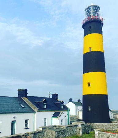
1844 (height nearly tripled in 1893). Active; focal plane 37 m (120 ft); two quick white flashes every 7.5 s; there is also an auxiliary light at a focal plane of 14 m (45 ft), showing a white or red flash, depending on direction, every 3 s. The light is also shown by day in foggy weather. 39.5 m (130 ft) tower with lantern and gallery; bivalve Fresnel lens. Tower painted with black and yellow horizontal bands; lantern painted white. Four keeper's houses; one of them is occupied by a resident keeper, one is used for storage, and the other two are available for overnight accommodations. The fog horn was deactivated in 2011. A 2009 photo is at right, Trabas has a closeup photo, a 2021 photo is available, Viktor Krizsan has a closeup photo, Lighthouse Accommodations has a page for the lighthouse, Marinas.com has aerial photos, and Google has a distant street view and a satellite view of the station. This is one of CIL's Twelve Great Lighthouses of Ireland. The original lighthouse, designed by George Halpin, had a height of 14 m (45 ft). One of the most complete light stations surviving in Ireland. In 2013 CIL announced plans to develop the light station with accommodations for overnight rental. In 2015 CIL announced plans to replace the historic rotating Fresnel lens with a modern LED light; this sparked protests throughout the area. In response to the uproar, CIL agreed to postpone any change for two years while engineers study other ways to safely remove the mercury used to rotate the lens. The two keeper's houses were renovated in 2016 and opened for vacation rental in 2017. Controversy exploded anew in 2020 when CIL announced revised plans to replace the Fresnel lens with an LED optic. Located about 5 km (3 mi) south of Killough, marking the entrance to Dundrum Bay. Accessible by a short walk from the end of the road, where parking is available. Site and tower closed, but the lighthouse can be viewed from outside the wall of the compound. Operator: Commissioners of Irish Lights (SSt. John's Point Lighthouse). Site manager (keepers houses): Irish Landmark Trust. . ARLHS NTI-022; CIL-1050; Admiralty A5958; NGA 6756.
[Annalong]
1820s (?). Inactive for many years. Approx. 5 m (17 ft) round white stone tower. Eric Jones has a photo, Google has a street view, and Bing has a satellite view. Jones writes that "In the old days a light used to be placed in the pepper-pot style white tower to assist ships wishing to enter the harbour." Peter Goulding visited this site and learned that there were originally two towers that functioned as a range for the narrow harbor entrance. Located on the south side of the Annalong River in Annalong. Site and tower closed (private property), but the light can be seen from nearby.
[Cranfield Point (Haulbowline shore station)]
1803. Inactive since 1824 (?). A stone lighthouse on Cranfield Point marked the entrance to Carlingford Lough before the Haulbowline lighthouse (next entry) was built. The lighthouse was lost to beach erosion in the 1860s but the keeper's house continued in use as a shore station for Haulbowline until 1922. The cottage survives today in private ownership. Google has a satellite view. Located on the north side of the entrance to the lough (this is the southernmost point of Northern Ireland). Site closed (private property).
St. John's Point Light
St. John's Point Light, Killough, October 2009
Wikimedia Creative Commons photo by Ardfern
Haulbowline
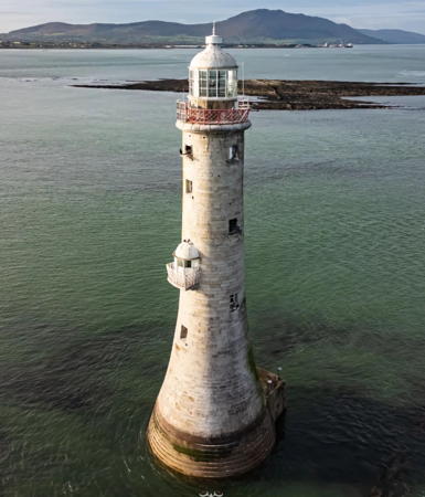
1824. Active; focal plane 32 m (105 ft); three white flashes every 10 s. 34 m (111 ft) tapered granite tower, with lantern and gallery, incorporating keeper's quarters and resting on a square base. The former fog horn was deactivated in 2009. The tower is unpainted; lantern painted white. Terry Stewart's 2009 photo shows a secondary lantern halfway up the tower; until 1922 this lantern displayed a "half tide" light to inform mariners that the tide was high enough for vessels to enter the lough. In addition, from 1873 to 2008 a continuous red "turning light" marking the start of the Carlingford Lough entrance channel was displayed from one of the lower windows of the tower. Anthony Cranney's photo is at right, Trabas also has a photo, Goulding has a page with many 2014 photos, Marinas.com has aerial photos, and Bing has a satellite view. This lighthouse is built on a dangerous rock, exposed only at low tide. The shore station was at Cranfield Point until 1922 and then at Greencastle. This was the first Irish offshore light to be automated, in 1965. Located in the middle of the entrance to Carlingford Lough, just on the northern side of the border between Ireland and Northern Ireland. Accessible only by boat. Site and tower closed. Operator: Commissioners of Irish Lights. ARLHS NTI-035; CIL-1020; Admiralty A5928; NGA 6704.
Haulbowline Range Front (Vidal Bank)
Date unknown. Active; focal plane 7 m (23 ft); white light occulting once every 3 s. 8 m (26 ft) octagonal skeletal tower with square metal watch (equipment) room topped by a gallery; red triangular daymark on the range line. Upper portion of tower painted white, lower portion green. Trabas has a photo and Bing has a satellite view. Located about 500 m (0.4 mi) northwest of the Haulbowline lighthouse. Accessible only by boat; good views from the Northern Ireland shore near Cranfield Point. Site and tower closed. Operator: Commissioners of Irish Lights. ARLHS NTI-016; CIL-1030; Admiralty A5932; NGA 6708.
Haulbowline Range Rear (Green Island)
Date unknown. Active; focal plane 12 m (40 ft); white light occulting once every 3 s. 14 m (46 ft) octagonal skeletal tower with square metal watch (equipment) room topped by a gallery; red triangular daymark on the range line. Upper 1/3 of tower painted white, lower 2/3 green. Trabas has a good photo, Ken Crozier has a photo of this light and the Haulbowline lighthouse, and Google has a fuzzy satellite view. Located in Carlingford Lough about 460 m (0.4 mi) west northwest of the front light. Accessible only by boat; good views from the Northern Ireland shore near Cranfield Point. Site and tower closed. Operator: Commissioners of Irish Lights. ARLHS NTI-015; CIL-1040; Admiralty A5934; NGA 6712.

Haulbowline Light, Carlingford Lough
unattributed Marinas.com photo

Information available on lost lighthouses:

Notable faux lighthouses:

Adjoining pages: North: Southwestern Scotland | East: Isle of Man | South: Eastern Ireland | West: Western Ireland

Return to the Lighthouse Directory index | Ratings key

Posted November 29, 2004. Checked and revised August 25, 2023. Lighthouses: 24, lightships: 1. Site copyright 2023 Russ Rowlett and the University of North Carolina at Chapel Hill.