Lighthouses of the United States: Michigan's Eastern Upper Peninsula

The United States of America is a federal union of 50 states and a capital district. The state of Michigan comes in two parts: the Lower Peninsula between Lakes Huron and Michigan and the Upper Peninsula between Lakes Michigan and Superior. Putting the two together the state has an astonishingly long coastline, so it is not surprising that Michigan has more lighthouses than any other U.S. state, by quite a large margin. The Directory has information on more than 170 Michigan lights. 

The first European outposts on the Upper Peninsula were established by France beginning at Sault Sainte Marie in 1668. Control passed to Britain after the Seven Year's War in 1763. Britain retained control of Michigan following the American Revolution, finally withdrawing in 1796-97. The U.S. Congress established Michigan Territory in 1805; for many years it included a large area of the northern Great Plains. Michigan with its present borders was admitted to the Union as the 26th state in 1837.

This page includes lighthouses of Chippewa County at the eastern end of the Upper Peninsula, including the numerous lights of the Saint Marys River, which drains Lake Superior into Lake Huron. (The river forms part of the boundary between the United States and Canada; Canadian lights on the river are listed on the Western Ontario page.) There are also separate pages for Southern Upper Peninsula and Northern Upper Peninsula lighthouses.

The state's lighthouse heritage is well recognized. Michigan is the only state that supports lighthouse preservation with a program of annual grants from the state to local preservation groups. All over the state volunteers are working hard to save and restore lighthouses. There is a state preservation society, the Michigan Lighthouse Conservancy, and the Great Lakes Lighthouse Keepers Association is also based in the state.

Aids to navigation on the Upper Peninsula are maintained by the U.S. Coast Guard Sector Sault Sainte Marie but ownership (and sometimes operation) of historic lighthouses has been transferred to local authorities and preservation organizations in many cases.

ARLHS numbers are from the ARLHS World List of Lights. USCG numbers are from Volume VII of the United States Coast Guard Light List.

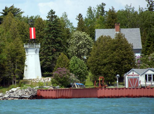
Round Island Light
Round Island (St. Marys River) Light, June 2014
photo copyright Michael Boucher; used by permission

General Sources
Michigan Lighthouses
Excellent photos and information posted by Kraig Anderson.
Lighthouses in Michigan, United States
Aerial photos posted by Marinas.com.
Lake Michigan Lighthouses and Lake Superior Lighthouses
Photos by C.W. Bash.
Leuchttürme in USA
Photos by Andreas Köhler.
Michigan Lighthouses
Outstanding photos by blogger Dan Weemhoff (DWHike).
Lighthouses of the Great Lakes
Photos by various photographers available from Wikimedia.
World of Lighthouses - U.S. Part of Great Lakes
Photos by various photographers available from Lightphotos.net.
Leuchttürme USA auf historischen Postkarten
Historic postcard images posted by Klaus Huelse.
Great Lakes Lighthouse Keepers Association
GLLKA encourages lighthouse preservation throughout the Great Lakes states, but it is best known for its work preserving the St. Helena Island and Cheboygan Range Front Lights in the Straits of Mackinac area.
Michigan Lighthouse Conservancy
This organization is dedicated to the preservation of lighthouses and life saving stations throughout the state.
Upper Peninsula Lighthouses on Lake Superior Open to the Public
Complete and well-illustrated accounts for 6 Upper Peninsula lights.
Michigan Lighthouse Assistance Program
This state program provides grants annually for lighthouse preservation.
Chippewa County Map
Detailed map from the Michigan State University Library.
U.S. Coast Guard Navigation Center: Light Lists
The USCG Light List can be downloaded in pdf format.
NOAA Nautical Charts
Official nautical charts for the coast can be viewed online.
Navionics Charts
Navigation chart for the Upper Peninsula.
 

Point Iroquois Light, Brimley, September 2023
Instagram photo by Tasha Heath
Southeast Lake Superior Lighthouses
**** Whitefish Point (2)
1861 (station established 1847). Active; focal plane 80 ft (24.5 m); two white flashes every 20 s, flashes separated by 5 s. 76 ft (23 m) square pyramidal skeletal tower with lantern, double gallery, and central cylinder attached to a 2-story wood keeper's house; twin DCB-224 aerobeacons (1968). Lighthouse painted white, galleries and lantern black; lantern roof is red. Brick fog signal building (1937), oil house (1910), and 2-story crew quarters building (1923). James Hatcher's photo is at right, Andy Kralick has a 2022 photo, Heidi Blanton has a good photo, Lighthouse Digest has published Bruce Lynn's history of the light station as well as a feature article, Anderson also has a fine page for the light station, Marinas.com has aerial photos, the National Archives has a historic photo of the station, Huelse has a historic postcard view, and Google has a street view and a satellite view of the station. This tower is one of the oldest onshore skeletal lighthouses in the U.S. An unusually well-preserved light station. The Great Lakes Shipwreck Historical Society (GLSHS), formed in 1978, has restored the station and operated it as a maritime museum since 1985. The bivalve 2nd order Fresnel lens from White Shoal Light in upper Lake Michigan (see the Western Lower Peninsula page) is on display. Located on a very prominent cape at the end of Whitefish Point Road north of Paradise. Site open, museum open daily May 1 through October 31. Owner/site manager: Great Lakes Shipwreck Museum . ARLHS USA-887; USCG 7-14530.
**** Point Iroquois (2)
1871 (station established 1855). Inactive since 1971. 65 ft (20 m) round brick tower with lantern and gallery, attached to 2-story brick keeper's house (1902). Lighthouse painted white; lantern and gallery black. The original 4th order Fresnel lens is at the Smithsonian Institution in Washington, DC. The original keeper's house (1870), used as assistant keeper's quarters after 1902, is also preserved. Volunteer caretakers live on site year round. Bash's photo is at the top of this page, Andy Kralick has a 2022 photo, Bradley Buhro has a good photo of the station, Marinas.com has aerial photos, and Google has a street view and a satellite view. The light was replaced by several buoys offshore. Restored through efforts of the Bay Mills/Brimley Historical Research Society, the light station is a museum. The 4th order Fresnel lens from the Martin Reef Light (see the Southern Upper Peninsula page) is on display. In 2021, with the help of HistoriCorps volunteers, the lighthouse was restored and repainted, removing layers of paint that had damaged the brickwork. In 2022 the Bay Mills Indian Community agreed with the Forest Service to assume management of the station; they announced plans to modernize the museum and open it all year. Located on Lakeshore Drive about 7.5 miles (12 km) northwest of Brimley at the entrance to the St. Marys River from Lake Superior. Site open, museum open Tuesday through Saturday all year. Owner: U.S. Forest Service. Site manager: Bay Mills Indian Community and Hiawatha National Forest (Point Iroquois Light Station ). ARLHS USA-624.
Whitefish Point Light
Whitefish Point Light, Paradise, June 2012
Flickr Creative Commons photo by James Hatcher

Upper St. Marys River (Sault Sainte Marie Area) Lighthouses
The St. Marys River is the outlet for Lake Superior. It is about 75 mi (125 km) long, draining southeastward into the northern end of Lake Huron. For much of its course it is braided, with numerous islands, some in the United States and some in Canada. The Soo Locks at Sault Ste. Marie, first opened in 1855, bypass the rapids of the river and open Lake Superior to navigation by large vessels. Lighthouses on the Canadian side of the river are described on the Western Ontario page.
Round Island Northwest (Light 26)
Date unknown. Active; focal plane 34 ft (10.5 m); quick-flashing red light. 34 ft (10.5 m) round tower with gallery; the light is shown from a fiberglass post atop the gallery. Lighthouse painted white with one narrow red horizontal band. C.M. Hanchey's photo is at right and Google has a satellite view. This light marks the junction of the Birch Point and Brush Point Channels, where vessels must make a sharp turn into or out of the river. Located on a shoal in the entrance to the St. Marys River, about 1.25 mi (2 km) north of Birch Point and 0.8 mi (1.3 km) northwest of Round Island. Accessible only by boat. Site open, tower closed. Owner/site manager: U.S. Coast Guard. USCG 7-14425.
Birch Point Range Front (2)
Date unknown (station established 1901). Active; focal plane 51 ft (15.5 m); continuous red light. 53 ft (16 m) square cylindrical skeletal tower carrying a large rectangular daymark colored red with a white vertical stripe. Weemhoff has a photo, Köhler has a photo, and Google has a satellite view and a distant street view. This is the eastbound entrance range for the St. Mary's River. Anderson has a historic photo of the original lighthouse, a 48 ft (15 m) square pyramidal skeletal tower. Located on the actual Birch Point off Birch Point Road, about 1 mi (1.6 km) to the west of the historic light station and about 2 miles (3 km) northeast of Brimley. Site and tower closed. Owner/site manager: U.S. Coast Guard. USCG 7-14430.
Birch Point Range Rear (2)
Date unknown (station established 1901). Active; focal plane 101 ft (31 m) continuous red light visible only on the range line. 75 ft (23 m) square skeletal tower with gallery, carrying a large rectangular daymark colored red with a white vertical stripe. Weemhoff has a photo and Google has a satellite view. The original lighthouse was a 53 ft (16 m) square pyramidal skeletal tower. Located in dense forest 3000 ft (915 m) southeast of the front light. Site and tower closed. Owner/site manager: U.S. Coast Guard. USCG 7-14435.
Round Island Northwest Light
Round Island Northwest Light, August 2011
Flickr Creative Commons photo by C.M. Hanchey
[St. Mary's River Upper Range Front (Round Island) (2)]
1864 (station established 1855). Inactive since 1886. Part of the foundation of this former lighthouse is still standing. No photo available but Google has a satellite view. This was a upbound range for vessels leaving the Soo Locks. Located on Round Island, a small island off Round Island Point. Famous Soo Locks Boat Tours has a lighthouse cruise for which this is one of the sights listed. Site status and site manager unknown.
[St. Mary's River Upper Range Rear (Birch Point)]
1864 (station established 1855). Inactive since 1886. The lighthouse, a 30 ft (9 m) square pyramidal wood tower, has been demolished. The 2-story wood Victorian keeper's house survives and is in use as a private residence. No photo available but Google has a satellite view. Famous Soo Locks Boat Tours has a lighthouse cruise for which this is one of the sights listed. Site closed; the house can only be seen from the water. Owner/site manager: private.
Brush Point Range Rear
Date unknown. Active; focal plane 71 ft (22 m); continuous red light. 57 ft (18 m) square skeletal tower with gallery. A distant view of the range lights is available and Google has a satellite view. This is an downbound range; the front light is on a short skeletal tower on an island in the river. Located on the river bank about 1/2 mi (800 m) south of Brush Point. Site status unknown. Owner/site manager: U.S. Coast Guard. USCG 7-14395.
[Vidal Shoals Channel Range Front (3?)]
Date unknown (station established 1899). Active; focal plane 32 ft (10 m); quick-flashing red light. Approx. 28 ft (8.5 m) square skeletal tower carrying a rectangular daymark colored red with a white vertical stripe. A distant view is available and Google has a satellite view. The original front range light, a round cast iron tower, was deactivated and stored in 1915; in 1927 it became the upper portion of the Fourteen Foot Shoal lighthouse in Lake Huron (see the Northeastern Lower Peninsula page). Located on the north side of the Soo Locks canal west of the International Bridge. Site and tower closed. Owner/site manager: U.S. Coast Guard. ARLHS USA-1280; USCG 7-14230.
Vidal Shoals Channel Range Rear (3?)
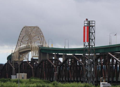
Date unknown (station established 1899). Active; focal plane 66 ft (20 m); red light, 3 s on, 3 s off. Approx. 60 ft (19 m) square skeletal tower carrying a rectangular daymark colored red with a white vertical stripe. A photo is at right and Google has a street view and a satellite view. This range guides downbound vessels on the final approach to the Soo Locks. The original rear range light was on a skeletal tower; it was replaced in 1904 by a 52 ft (16 m) octagonal wood tower with lantern and gallery. That lighthouse was demolished in 1915 and the light was returned to the skeletal tower. Located on the north side of the Soo Locks canal just west of the Sault Ste. Marie International Bridge, 885 ft (270 m) east of the front light. Site and tower closed. Owner/site manager: U.S. Coast Guard. ARLHS USA-1281; USCG 7-14235.

Vidal Shoals Channel Range Rear Light, Sault Sainte Marie, July 2020
photo copyright FoxyFan13; used by permission
 
* Frying Pan Island (relocated to Sault Ste. Marie)
1882. Inactive since 1937. 18 ft (5.5 m) round cast iron tower with lantern and gallery. Bash's photo is at right, Köhler has a photo, the Coast Guard has a historic photo, and Google has a street view and a satellite view. This lighthouse was built at Frying Pan Island in the De Tour Passage just southeast of De Tour Village. After being replaced by a post light it stood abandoned for half a century. In 1988 it was retrieved, restored and placed at the entrance to the Coast Guard office in Sault Ste. Marie. Located at 337 Water Street near the eastern entrance to the Soo Locks in downtown Sault Ste. Marie. Site open, tower closed. Owner: U.S. Coast Guard. Site manager: Sault Ste. Marie Coast Guard Station. ARLHS USA-312.
* Mission Point (Light 99, Little Rapids Cut Upper West) (3?)
Date unknown (station established 1895). Active; focal plane 32 ft (10 m); continuous green light. 30 ft (9 m) square steel skeletal tower with a square equipment shed on the gallery. Equipment building painted white. 2-story wood keeper's house. Köhler has a photo, Mark Setgo has a photo, the Coast Guard has a historic photo of the station, and Google has a street view and a satellite view. At Mission Point vessels bound downstream make a sharp turn into the Hay Channel, which separates the U.S. mainland from Sugar Island. The original lighthouse, a 2-story keeper's house with a lantern on the roof, was built on a pier about 5/8 mi (1 km) northwest of the point. The assistant keeper lived in the house that survives on Mission Point. The lighthouse was replaced by a skeletal tower in 1919 and both light and pier were removed in 1932 leaving the assistant keeper's house as the only remnant of the station. John Kulba has contributed photos showing renovations to the building in progress during the summer of 2002. Apparently the building is now used for offices of the Corps of Engineers. Anderson has a 1935 photo of the house; on the right is a post light then called the Little Rapids Cut Upper West Light. The modern light is known only as Light 99. Located at the end of East Portage Avenue in Sault Sainte Marie, adjacent to the Sugar Island Ferry terminal. Site and tower closed, but parking is available nearby. Owner: U.S. Coast Guard. Site manager: U.S. Army Corps of Engineers Soo Locks. ARLHS USA-441; USCG 7-14110.

Frying Pan Island Light (relocated to Sault Sainte Marie), October 2006
Flickr Creative Commons photo by C.W. Bash

Sugar Island Area Lighthouses
Sugar Island is a large island east of Sault Sainte Marie. The island has a population of more than 600 but most of it is forested and undeveloped. The dredged channel is on the west side of the island, passing through Lake Nicolet; this section of the waterway is entirely in the U.S.
Bayfield Rock Range Front (4?)
Date unknown (station established 1892). Active; focal plane 35 ft (11 m); continuous white light. 32 ft (10 m) square steel skeletal tower, carrying a large rectangular daymark colored red with a white vertical stripe. Köhler has a photo, Lightphotos.net also has Köhler's photo, a distant view of the range is available, and Google has a satellite view. This downstream range guides ships leaving Sault Sainte Marie. The original light, a lantern on a post, was replaced by a 28 ft (8.5 m) octagonal wood tower in 1913. Located on the northwestern point of Sugar Island. Site open, tower closed. Owner/site manager: U.S. Coast Guard. USCG 7-14160.
Bayfield Rock Range Rear (4?)
Date unknown (station established 1892). Active; focal plane 54 ft (16.5 m); continuous white light. 52 ft (16 m) square steel skeletal tower, carrying a large rectangular daymark colored red with a white vertical stripe. A distant view of the range is available and Google has a satellite view. The original light, a lantern on a post, was replaced by a 38 ft (12 m) octagonal wood tower in 1913. Located in a forest on the northwestern tip of Sugar Island. Site open, tower closed. Owner/site manager: U.S. Coast Guard. USCG 7-14165.
Frechette Point Range Rear (4?)
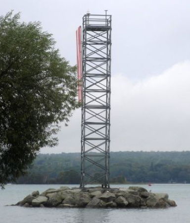
Date unknown (station established 1892?). Active; focal plane 93 ft (28 m); continuous green light. 87 ft (26 m) triangular steel skeletal tower carrying a large rectangular daymark colored red with a white vertical stripe. Michael Boucher's photo is at right, Lightphotos.net has Köhler's photo and a second photo, a distant view (tower at the left edge of the photo) is available, and Google has a satellite view. This upstream range was established at least by 1895. Anderson has a historic photo of the second light, a square pyramidal skeletal tower with a focal plane of 80 ft (24 m). Located on the southern point of Island Number One, across from Riverside Drive just north of East Three Mile Road. Accessible only by boat. Site open, tower closed. Owner/site manager: U.S. Coast Guard. USCG 7-14020.
Frechette Point Range Front (4?)
Date unknown (station established 1892?). Active; focal plane 38 ft (12 m); quick-flashing green light. 35 ft (11 m) square cylindrical skeletal tower carrying a large rectangular daymark colored red with a white vertical stripe and mounted on a round concrete pier. Lightphotos.net has a photo, Köhler has a photo and Google has a satellite view. Located on the west side of the channel just south of Frechette Point. Accessible only by boat. Site open, tower closed. Owner/site manager: U.S. Coast Guard. USCG 7-14015.
Frechette Point Range Rear Light
Frechette Point Range Rear Light, June 2014
photo copyright Michael Boucher; used by permission
Upper Nicolet Range Rear
Date unknown. Active; focal plane 82 ft (25 m); continuous white light. Approx. 70 ft (21 m) triangular steel skeletal tower carrying a large rectangular daymark colored red with a white vertical striper. No photo available but Google has a satellite view. This upstream range guides vessels leaving Lake Nicolet. Located in a densely forested area of northwestern Sugar Island. Site status unknown. Owner/site manager: U.S. Coast Guard. USCG 7-13960.
Upper Nicolet Range Front
Date unknown. Active; focal plane 42 ft (13 m); continuous white light. Approx. 38 ft (12 m) triangular steel skeletal tower carrying a large rectangular daymark colored red with a white vertical striper. No photo available but Google has a satellite view. Located near the shore of Sugar Island southeast of Frechette Point. Site status unknown. Owner/site manager: U.S. Coast Guard. USCG 7-13955.
* Six Mile Point Range Rear (3)
Date unknown (station established 1895). Active; focal plane 65 ft (20 m); white light; 3 s on, 3 s off. 65 ft (20 m) square cylindrical steel skeletal tower, carrying a large rectangular daymark colored red with a white vertical striper. Köhler's photo is at right, Lightphotos.net also has Köhler's photo, Anderson has J.A. Clay's photo, and Google has a satellite view. This is a downstream range for vessels after they make the turn at the Bayfield Rock Rear Light. The front light is on a 30 ft (9 m) round cylindrical (D9) tower. A brick oil house survives from the earlier light station. The original rear lighthouse was saved and is on display at the Les Cheneaux Maritime Museum in Cedarville (see the Southern Upper Peninsula page), and the original front lighthouse is displayed at the DeTour Passage Historical Museum in DeTour Village (see below). Located just off the mainland shore of the waterway at the end of East Five Mile Road. Accessible only by boat, but there are closeup views from shore. Site open, tower closed. Site open, tower closed. Owner/site manager: U.S. Coast Guard. USCG 7-14050.
* Sugar Island (Leading Light)
Date unknown. Active; focal plane 50 ft (15 m); white light; 3 s on, 3 s off. 49 ft (15 m) square cylindrical steel skeletal tower. No photo available but Google has a satellite view. The light guides vessels downstream. Located on the west side of Sugar Island at the end of Laramie Lane, about 1.5 mi (2.5 km) north of the head of Lake Nicolet. Accessible by road. Site open, tower closed. Owner/site manager: U.S. Coast Guard. USCG 7-14040.
* Harwood Point West Range Rear
Date unknown (Harwood Point Range established 1892). Active; focal plane 65 ft (20 m); continuous white light. Approx. 13 m (43 ft) round cylindrical steel tower, painted white, carrying a rectangular daymark colored red with a white vertical stripe. No photo available but Google has a satellite view. Located on the north side of south Homestead Road at Harwood Point, the southern tip of Sugar Island. Site open, tower closed. Owner/site manager: U.S. Coast Guard. USCG 7-13205.
* Harwood Point East Range Rear
Date unknown (Harwood Point Range established 1892). Active; focal plane 65 ft (20 m); continuous red light. Approx. 13 m (43 ft) round cylindrical steel tower, painted white, carrying a rectangular daymark colored red with a green vertical stripe. No photo available but Google has a satellite view. Located on the north side of south Homestead Road at Harwood Point, the southern tip of Sugar Island. Site open, tower closed. Owner/site manager: U.S. Coast Guard. USCG 7-13195.

Six Mile Point Range Rear Light, September 2016
photo copyright Andreas Köhler; used by permission

Neebish Island Area Lighthouses
The St. Marys River is divided by Neebish Island, a large forested island with a small permanent population and many summer cottages. Upbound ship traffic passes to the east of the island (along the U.S./Canada border), and downbound ships use the dredged channel on the west side (entirely in the U.S.). Neebish Island is accessible by ferry from Barbeau.

Middle Neebish South Range Rear
Date unknown. Active; focal plane 50 ft (14 m); continuous white light. This tower also carries the front light (focal plane 40 ft (12 m); quick-flashing white light) of the West Neebish Upper Range (next entry). 50 ft (14 m) triangular cylindrical steel skeletal tower mounted on a round concrete pier. No photo available but Google has a satellite view. The Middle Neebish Range guides upbound vessels through the channel on the north side of Neebish Island. Located in Lake Nicoley about 2 km (1.25 mi) off the northwestern tip of Neebish Island. Accessible only by boat. Site open, tower closed. Owner/site manager: U.S. Coast Guard. USCG 7-13280 (Middle Neebish) and 7-13470 (West Neebish).
West Neebish Upper Range Rear
Date unknown. Active; focal plane 80 ft (24 m); continuous white light. 80 ft (24 m) square cylindrical steel skeletal tower. No photo available but Google has a satellite view. The range guides downbound vessels on the approach to Neebish Island. Located at the water's edge at the northwestern tip of Neebish Island. Accessible only by boat. Site open, tower closed. Owner/site manager: U.S. Coast Guard. USCG 7-13475.
Lower Nicolet West Range Front (Middle Neebish) (1)
1907 (relocated from Windmill Point, Detroit, in 1931). Station established 1895. Inactive since 1993. 55 ft (17 m) slender round cylindrical steel tower, painted red. Weemhoff's photo is at right, Dawn Carlson has a 2020 photo, Lightphotos.net has a photo, the Coast Guard has a historic photo, and Google has a satellite view. Google also has a satellite view of the 1-1/2 story keeper's house for the Middle Neebish lights; it is at the end of Brander Road about 1 mi (1.6 km) east southeast of the front lights. The Lower Nicolet Range lights are successors to the Lower Hay Lake Cut Range, which was established in 1895. Located on the north end of Neebish Island. The lighthouses are accessible by a hike of about 1 mile (1.6 km) from the end of Brander Road (although Weemhoff found this hike challenging due to wet conditions on the island). Site open, tower closed. Owner/site manager: U.S. Coast Guard. ARLHS USA-1092.
Lower Nicolet West Range Front (Middle Neebish) (2)
1993 (station established 1895). Active; focal plane 53 ft (16 m); continuous white light. Approx. 45 ft (14 m) square skeletal tower. The tower carries a large rectangular daymark painted red with a white stripe. Weemhoff's photo is at right. Located next to the historic lighthouse. Site open, tower closed. Owner/site manager: U.S. Coast Guard. USCG 7-13365.
Lower Nicolet East Range Front (2?)
Date unknown. Active; focal plane 54 ft (16.5 m); continuous green light. Approx. 45 ft (14 m) square skeletal tower. The tower carries a large rectangular daymark painted red with a green stripe. Weemhoff has a photo (4/5 the way down the page) showing all three front range lights, and Google has a satellite view. Located about 200 ft (60 m) east of the West Range Front Light. Site open, tower closed. Owner/site manager: U.S. Coast Guard. USCG 7-13355.
Lower Nicolet East Range Rear (2?)
Date unknown. Active; focal plane 75 ft (23 m); continuous green light. Approx. 45 ft (14 m) square skeletal tower. The tower carries a large rectangular daymark painted red with a green vertical stripe. Anderson has a photo, Weemhoff has a photo (halfway down the page) and Google has a satellite view. Located 586 yd (535 m) south southeast of the East Range Front Light. Site open, tower closed. Owner/site manager: U.S. Coast Guard. USCG 7-13360.
Middle Neebish Light
Middle Neebish Lights, Neebish Island, November 2007
Flickr photo copyright Dan Weemhoff; used by permission
Lower Nicolet West Range Rear (2)
Date unknown. Active; focal plane 100 ft (31 m); continuous white light. Approx. 60 ft (18 m) square cylindrical steel skeletal tower. The tower carries a large rectangular daymark painted red with a white vertical stripe. Anderson has a photo, Weemhoff has a photo (4/5 the way down the page), and Google has a satellite view. The original lighthouse was a steel tower similar to the original front lighthouse and, like that lighthouse, relocated from Windmill Point, Detroit. However the light was on a skeletal tower at least by 1958. Located 1250 yd (1145 m) south southeast of the front light, to which it is connected by a powerline easement. Site open, tower closed. Owner/site manager: U.S. Coast Guard. USCG 7-13370.
Oak Ridge Range Front
Date unknown. Active; focal plane 70 ft (21 m); continuous green light. 70 ft (21 m) square cylindrical steel skeletal tower. The tower carries a large rectangular daymark painted red with a white vertical stripe. Lightphotos.net has Köhler's photo and Google has a satellite view and a very distant street view. This is an downbound range guiding vessels on a long north-to-south reach on the west side of Neebish Island. Located just offshore a short distance upsteam from the Neebish Island Ferry terminal. Accessible only by boat, but there are good views from the ferry. Site open, tower closed. Owner/site manager: U.S. Coast Guard. USCG 7-13515.
Oak Ridge Range Rear
Date unknown. Active; focal plane 144 ft (44 m); continuous green light. 70 ft (21 m) square pyramidal steel skeletal tower. The tower carries a large rectangular daymark painted red with a white vertical stripe. Lightphotos.net has Köhler's photo (also seen at right) and Google has a satellite view. Located in a forest 650 yd (595 m) south of the front light. Site status unknown. Owner/site manager: U.S. Coast Guard. USCG 7-13520.
Winter Point Range Rear (3)
Date unknown (station established 1892). Active; focal plane 82 ft (25 m); continuous white light. 60 ft (18 m) square pyramidal steel skeletal tower. The tower carries a large rectangular daymark painted red with a white vertical stripe. Dan Patrick has a 2023 photo of the two range lights and Google has a satellite view. Winter Point is the southern tip of Neebish Island. The range guides upbound vessels leaving Lake Munuscong. Located in a forest 4000 ft (1220 m) northwest of the front light; a cleared sightline connects the lights. Accessible by hiking the East Tally-Ho Trail. Site open, tower closed. Owner/site manager: U.S. Coast Guard. USCG 7-13025.
Winter Point Range Front (3)
Date unknown (station established 1892). Active; focal plane 46 ft (14 m); continuous white light. 42 ft (13 m) square cylindrical steel skeletal tower. The tower carries a large rectangular daymark painted red with a white vertical stripe. Anderson's page has a photo, Dan Patrick has a 2023 photo of the two range lights, and Google has a satellite view. The light was shown originally through a window at the gable end of a 1-1/2 story keeper's house. The light was on a skeletal tower at least by 1921. Located near the southern tip of Neebish Island. Accessible by hiking the East Tally-Ho Trail. Site open, tower closed. Owner/site manager: U.S. Coast Guard. ARLHS USA-1283; USCG 7-13015.

Oak Ridge Range Rear Light, September 2016
photo copyright Andreas Köhler; used by permission
Dark Hole East Range Rear (3?)
Date unknown. Active; focal plane 75 ft (23 m); continuous green light. 70 ft (21 m) square cylindrical steel skeletal tower. No photo available but Google has a satellite view. The light guides downbound vessels that have chosen to use the East Neebish passage. The front light is on a 33 ft (10 m) skeletal tower. Located at the north end of Rains Island, which is separated from the southeastern corner of Neebish Island by a narrow wetland. Site open, tower closed. Owner/site manager: U.S. Coast Guard. USCG 7-13175.
Dark Hole West Range Rear (3?)
Date unknown. Active; focal plane 75 ft (23 m); continuous green light. 70 ft (21 m) square cylindrical steel skeletal tower. No photo available but Google has a satellite view. The light guides downbound vessels that have chosen to use the East Neebish passage. The front light is on a 33 ft (10 m) skeletal tower. Located about 100 yd (90 m) northwest of the East Range Rear light. Site open, tower closed. Owner/site manager: U.S. Coast Guard. USCG 7-13185.
[Munuscong Junction]
Date unknown. Active; focal plane about 15 m (49 ft); three green flashes, in a 2+1 pattern, every 6 s. Approx. 12 m (39 ft) round D9 tower, painted green with a red horizontal band, mounted on a concrete pier. The Coast Guard photo at right shows a crew repairing the light in February 2023. Google has a satellite view. Located in upper Munuscong Lake at the junction of the East and West Neebish channels. Accessible only by boat. Site open, tower closed. Owner/site manager: U.S. Coast Guard. USCG 7-13030.
 

Munuscong Junction Light, St. Mary's River, February 2023
U.S. Coast Guard photo posted by mlive.com
 

Lower Saint Marys River Lighthouses
Round Island (St. Marys River) (1)
1892. Inactive since 1923. Approx. 50 ft (15 m) square cylindrical wood tower with lantern and gallery, attached to 1-1/2 story wood keeper's house. The active light is on a post: focal plane 28 ft (8.5 m); red or white flash every 2.5 s, depending on direction. Michael Boucher's photo is at the top of this page, Frank Smiddy has a 2017 photo, Bash has a 2009 photo, the Coast Guard has a historic photo of the station, and Google has a satellite view. Not to be confused with the Round Island Light in the Straits of Mackinac (see the Southern Upper Peninsula page) or yet another Round Island at the western end of the river (see above), this Round Island is between Lime Island and Point aux Frenes, northeast of Goetzville. The house is a private summer residence. In 2000 the building was renovated and expanded by the owners, Paul and Georgeann Lindberg; it looks great now but it has been altered somewhat from its historic appearance. The lighthouse was on sale in the fall of 2013 for just under $2 million. It remained on sale as of 2021 but had sold by fall 2022. Located at the west end of the island, in the northern end of Lake Munuscong. Accessible only by boat. Site and tower closed. Owner/site manager: private. ARLHS USA-709. Active light: USCG 7-12940.
Pipe Island
1888. Active; focal plane 52 ft (16 m); white flash every 10 s. 44 ft (13.5 m) tower, consisting of a 25 ft (7.5 m) octagonal brick tower topped by a steel skeletal tower carrying a large daymark colored red with a white vertical stripe. Brick tower painted white, skeletal tower black. The original lantern was replaced by the skeletal tower in 1920. James Hatcher's photo is at right, Paul Hancock has a view from the water, the Coast Guard has a historic photo of the lighthouse in its original form, and Google has a satellite view of the station. The island is privately owned and except for the buildings it is protected by a conservation easement held by the Little Traverse Conservancy. In 2002 the island was sold to Mary and John Kostecki, who operated it for several years as a vacation resort with three cottages for rental. The Kosteckis began work restoring the lighthouse and they hoped eventually to rebuild the lantern. However, in 2006 the island was listed for sale and apparently sold; the new owners are not known. Located on the southwest side of Pipe Island, northeast of DeTour Village and at the southern end of Lake Munuscong. Accessible only by boat. Site and tower open to paying guests. Owner (tower): U.S. Coast Guard. Site manager: private. ARLHS USA-602; USCG 7-12875.
* [Six Mile Point Range Front (2) (relocated)]
1907 (station established 1895). Inactive. 20 ft (6 m) tapered round steel tower, painted white. C.M. Hanchey has a 2011 photo, a 2012 photo and a 2020 closeup are available, and Google has a street view and a satellite view. This tower was built on the St. Marys River south of Mission Point, a few miles southeast of Sault Sainte Marie. Located beside Huron Street just north of the Drummond Island Ferry terminal in DeTour Village. Site open, tower closed. Owner/site manager: DeTour Passage Historical Museum .

Pipe Island Light, St. Mary's River, June 2013
Flickr Creative Commons photo by James Hatcher

Lake Huron Lighthouse
DeTour Reef
1931. Active; focal plane 74 ft (22.5 m); white flash every 10 s (red sector covers shoals). 63 ft (19 m) square cylindrical reinforced concrete tower with lantern and gallery rising from 2-story reinforced concrete keeper's quarters; VRB-25 aerobeacon (1996). Lighthouse painted white, lantern black with a red roof. Fog horn (2 blasts every 60 s) as needed. The 3-1/2 order Fresnel lens (1936), removed in 1988, is now on display at the DeTour Passage Historical Museum. The original diaphone fog signal, discovered in storage in 1998, is on exhibit at the Drummond Island Historical Museum. Frank Post's 2021 photo is at right, Andy Kralick has a 2022 photo, the Coast Guard has a historic photo, and Google has a satellite view. The De Tour Reef Light Preservation Society is working for the preservation of the lighthouse. Lighthouse Digest has Cynthia Johnson's 1999 article profiling the beginnings of this effort. In 2003-04 the exterior of the lighthouse was restored in a project funded by $960,000 in federal and state grants. In 2005 the lighthouse was added to the National Register of Historic Places and ownership was transferred to the preservation group under NHLPA. In 2013 the state granted $60,000 to repair the roof and clean up water damage caused by leaks. In 2018 the Lighthouse Assistance Program granted $60,000 to repair additional leaks. In March 2022 the underwater power cable to the lighthouse failed; engineers are trying to come up with the best fix. Programs for 2022 were cancelled but a limited program, including rustic overnight stays, was provided in 2023. Located on a reef in Lake Huron off the entrance to the St. Marys River south of DeTour Village. Accessible only by boat. Site open; tower closed in 2022. (Ordinarily guided tours of the lighthouse are available on Saturdays mid June thorugh Labor Day (early September).) Owner/site manager: De Tour Reef Light Preservation Society . ARLHS USA-226; USCG 7-12770.

Information available on lost lighthouses:

  • DeTour Point (1847-1931), Lake Huron at the St. Mary's River entrance. The 1861 lighthouse was a sibling of the Whitefish Point Light (see above) and the Manitou Island Light (see the Northern Upper Peninsula page). The 2-story keeper's house built in 1861 survived until it was destroyed by fire in April 2021. ARLHS USA-1324.
  • Harwood Point East Range Front (1930-?), St. Marys River, Neebish Island. The lighthouse was replaced by a small range beacon; see above for the rear light.
  • Middle Lake George (1892-?), St. Marys River, east side of Sugar Island. The lighthouse was replaced by buoys marking the channel; a submerged crib is charted. The main channel is on the west side of Sugar Island.
  • St. Mary's River Lower Range Front (1887-?), St. Marys River. Nothing remains of this lighthouse. ARLHS USA-803.

Notable faux lighthouses:


DeTour Reef Light, DeTour Village, July 2021
ex-Google Maps photo by Frank Post

Adjoining pages: North: Western Ontario | South: Western Lower Peninsula | Southwest: Southern Upper Peninsula | West: Northern Upper Peninsula

Return to the Lighthouse Directory index

Posted May 2005. Checked and revised October 24, 2023. Lighthouses: 35. Site copyright 2023 Russ Rowlett and the University of North Carolina at Chapel Hill.