Lighthouses of Sweden: Stockholm Area

The nation of Sweden (Sverige in Swedish) is the largest country of northern Europe, occupying the entire west coast of the Baltic Sea. Along with its lengthy coast Sweden has a distinguished lighthouse history and a good record of preserving its historic lights. The Swedish Lighthouse Society (Svenska Fyrsällskapet) works actively for the preservation of the lighthouses.

Sweden is divided into 21 counties (län) and the counties are subdivided into townships and municipalities (kommuner). This page covers lighthouses of the greater Stockholm area of Sweden as well as the municipalities of Norrtälje, Österåker, and Vaxholm lying to the northeast of Stockholm; this is the northern half of Stockholm County (Stockholms Län). The coastline of this area includes the northern part of the maze of islands and waterways known as the Stockholm Archipelago (Stockholms Skärgård in Swedish). The many channels and passages require a large number of lighthouses, but nearly all of them are located offshore or on isolated islands; only a few are easily accessible to the public.

Lighthouses of the eastern and southern portions of the Stockholm Archipelago are described on the Värmdö to Nynäshamn page.

The Swedish word for a lighthouse is fyr. The front light of a range is the nedrefyr (lower light) and the rear light is the övrefyr (upper light). Ö is an island, holme is an islet, skär is a skerry (a tiny island or rocky reef), grund is a shoal or shallow, sund is a strait (often between an island and the mainland), vik is a bay, hav is a sea, udde is a headland, flod is a river, and hamn is a port or harbor.

Aids to navigation in Sweden are maintained by the Swedish Maritime Administration (Sjöfartsverket). Many of the major lighthouses have resident attendents and guided tours can often be arranged.

ARLHS numbers are from the ARLHS World List of Lights. SV numbers are from the Sjöfarsverket light list (Fyrlista) as reported by the Swedish Lighthouse Society. Admiralty numbers are from volume C of the Admiralty List of Lights & Fog Signals. U.S. NGA List numbers are from Publication 116.

General Sources
Swedish Lighthouse Society (Svenska Fyrsällskapet, SFA)
The Society is active in promoting the preservation of Swedish lighthouses.
Svenskt Fyrväsende
From the SFA web site, data and photos for many of the lighthouses.
Online Lists of Lights - Sweden
Photos by various photographers posted by Alexander Trabas.
Lighthouses in Sweden
Photos by various photographers available from Wikimedia.
Lista över fyrar i Stockholms skärgård
Swedish Wikipedia's list of lighthouses of the Stockholm Archipelago; photos are provided for many of them.
Sweden Lighthouses
Aerial photos posted by Marinas.com.
Fyr Vi Har Passeret (Lighthouses We've Passed)
Photos of Baltic lighthouses taken by two Danish sailors, Jette and Ole.
Leuchttürme in Schweden
Photos posted by Bernd Claußen.
Schwedische Leuchttürme auf historischen Postkarten
Historic postcard views posted by Klaus Huelse.
Navionics Charts
Navigation chart for Sweden.


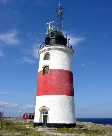
Söderarm Light, Åland Sea, October 2016
SFA Creative Commons photo by JA

Norrtälje Lighthouses

Singö Area Lighthouses
Singö is a large island just off the coast at the border between Stockholm and Uppsala counties. There are fewer than 400 permanent residents but the island has several thousand summer homes. It is accessible by bridge.
Understen (1)
1848. Inactive since 1916. 13 m (43 ft) round rubblestone tower with lantern and gallery. The lighthouse is unpainted. The station includes several keeper's houses and auxiliary buildings plus a tall communications and maritime traffic control tower. Wikimedia has Esbjörn Hillberg's photo (seen at right), T. Redelius has a fine 2006 photo and a photo of the entire station, Swedish Wikipedia has an article, Marinas.com has aerial photos, and Google has a satellite view. Huelse has a postcard photo (taken from the gallery of the newer lighthouse) that shows the original appearance of the station. This light station stands in the northern entrance to the strait connecting the Gulf of Bothnia to the Baltic Sea, west of the Åland Islands; this strait is called the Åland Sea (Ålands hav) in Sweden. A 9 m (30 ft) daybeacon was built here in 1809; after it was destroyed by a storm in 1839 it was replaced by an 11 m (36 ft) beacon. The 1848 keeper's house is one of the surviving buildings. The station is staffed by resident caretakers in season. Located on a small island about 9 km (5.5 mi) northeast of Singö and about 20 km (13 mi) northwest of the westernmost of the Ålands. Accessible only by boat. Site open, tower closed. ARLHS SWE-402.
Understen (2)
1916 (station established 1848). Active; focal plane 48 m (158 ft); four white flashes every 15 s. 39 m (128 ft) round 2-stage concrete tower with lantern and gallery; the lower stage is tapered and the upper stage is cylindrical. Lighthouse painted white with a broad black band around the upper stage. The 3rd order Fresnel lens in use was installed in 1922. A photo is at right, T. Redelius has a photo of the station, Trabas has a very distant view, Marinas.com has aerial photos, Huelse has a postcard view of the newer tower, and Bing has a satellite view. Located near the older lighthouse. Accessible only by boat. Site open, tower closed. ARLHS SWE-071; SV-2201; Admiralty C6288; NGA 10016.
Singö Stångskär
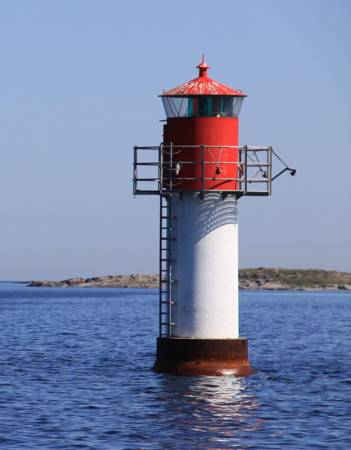
1952. Active; focal plane 6 m (20 ft); three flashes every 9 s, white, red or green depending on direction. 5.5 m (18 ft) round cylindrical concrete tower with lantern and gallery. Tower painted white, lantern red with a white roof. Trabas has a distant view and Google has a satellite view. Located on a small island off the northeast coast of Singö. Accessible only by boat. Site open, tower closed. ARLHS SWE-342; SV-2234; Admiralty C6282; NGA 10004.

Old and new Understen Lights, Åland Sea, May 2007
Wikimedia Creative Commons photo by Esbjörn Hillberg
Svartklubben
1820. Active; focal plane 19.5 m (64 ft); two long (2 s) flashes every 15 s, white, red or green depending on direction. 12 m (39 ft) old-style round cylindrical stone tower with an off-center lantern and gallery. Lighthouse painted white with a black horizontal band at the top of the tower. Gittel Larsson's photo is at right, Trabas has a good photo, Johan Modig has a 2021 photo, Huelse has a postcard view, and Google has a satellite view. This historic lighthouse marks the west edge of the passage between Sweden and the Åland Islands, at the mouth of the Gulf of Bothnia. The tower was originally built to carry an open fire. A lantern with an oil-fired lamp was added in 1849. The present lantern and 4th order Fresnel lens were transferred in 1882 from one of the Nordkoster lighthouses (see the Tanum Area page). Located on a small island off the eastern tip of the island of Singö. Accessible only by boat. Site open, tower closed. . ARLHS SWE-386; SV-2228; Admiralty C6290; NGA 9992.

Väddö and Björkö Lighthouses
Väddö is a large island barely separated from the mainland by the narrow Väddö Kanal (channel). The southern part of the island, which projects eastward into the gulf, is often called Björkö.

Strömsviken Övre
1962. Active; focal plane 12 m (39 ft); four flashes every 12 s, white, red or green depending on direction; also a white light, 2 s on, 2 s off. 12 m (39 ft) square skeletal tower, painted white. Trabas has a photo and Google has a distant satellite view. The range guides vessels northbound in the Väddö Kanal. The front light is on a short post in the water. Located on a small island in the middle of the channel about 4 km (2.5 mi) south of the north end. Accessible only by boat. Site open, tower closed. SV-2353.01; Admiralty C6309.1; ex-NGA 10123.

Svartklubben Light, Singö, March 2012
ex-Panoramio photo copyright Gittel Larsson; used by permission
Simpnäsklubb (Skomakaren) (2)
1943 (station established 1869). Active; focal plane 20 m (66 ft); one long flash every 8 s, white, red or green depending on direction. 16 m (52 ft) round cylindrical concrete tower with lantern and gallery, painted white with one narrow green horizontal band. Trabas has a photo and Google has a satellite view. Huelse has a postcard view of the original lighthouse, a 1-1/2 story wood keeper's house with an octagonal lantern mounted at one end; the stone foundation of the house survives beside the modern lighthouse. Wikimedia has a historic photo showing both lighthouses. The original lantern is on display at Simpnäs (see below). Located on a skerry off the northeast side of Björkö. Accessible only by boat. Site open, tower closed. ARLHS SWE-340; SV-2540; Admiralty C6362; NGA 9976.
Näskubben (2)
1933 (station established 1850). Active; focal plane 10 m (33 ft); three flashes every 9 s, white, red or green depending on direction. 7 m (23 ft) round cylindrical concrete tower with lantern and gallery. Tower painted white, lantern red with a white roof. Trabas has an excellent photo and Google has a satellite view. The keeper's house shown in Huelse's postcard view has been demolished although the foundation remains. Located on a promontory at the eastern tip of Björkö, marking the entrance to the strait separating Björkö from Arholma. Site status unknown (may be surrounded by private property). ARLHS SWE-285; SV-2545; Admiralty C6366; NGA 10036.
* Simpnäsklubb (1) (lantern)
1869. Inactive since 1944. 4 m (13 ft) octagonal tower with the lantern and gallery from the original Simpnäsklubb lighthouse. Rasmus Troedson has a closeup 2021 photo, Bo Justusson also has a photo (halfway down the page), and Google has a street view and a satellite view. Located next to a small nautical museum maintained by the Björkö-Arholma Sailors Association on the waterfront of Simpnäs, about 2 km (1.2 mi) south of the present lighthouse. Site open, tower closed. Owner/site manager: Björkö-Arholma Sjöfartsmuseum.
* Simpnäsgrynnan
1968. Active; focal plane 7 m (23 ft); white, red or green light, depending on direction, 1 s on, 1 s off. 7 m (23 ft) round cylindrical concrete tower with lantern and gallery. Tower painted white, lantern red. Chris Goldberg's photo is at right, Trabas has a photo, and Google has a satellite view. Located offshore about 600 m (0.4 mi) southeast of the Simpnäs waterfront. Accessible only by boat, but easily seen from shore. Site open, tower closed. SV-2557; Admiralty C6371; NGA 10044.
Simpnäsgrynnans Fyr
Simpnäsgrynnan Light, Simpnäs, June 2009
Flickr Creative Commons photo by Chris Goldberg
Dejeudden
1939. Active; focal plane 8 m (26 ft); quick-flashing white, red or green light depending on direction. Approx. 6 m (20 ft) post mounted on a small equipment shed. Tower painted white, lantern red. Trabas has a photo and Google has a distant satellite view. Located on a point of land about 2.5 km (1.5 mi) south of Simpnäs. May be accessible only by boat. Site open, tower closed. Active light: SV-2558; Admiralty C6372; NGA 10048.
Svedudden
Date unknown (station established 1883). Active; focal plane 7 m (23 ft); four flashes every 12 s, white, red or green depending on direction. 7 m (23 ft) round cylindrical concrete tower with lantern and gallery. Tower painted red, lantern white with a red roof. Trabas has a photo and Google has a satellite view. Located on a point of land about 2.5 km (1.5 mi) south of Simpnäs. May be accessible only by boat. Located on a point of land marking the narrowest point of the passage between Björkö and Arholma, about 4 km (2.5 mi) south of Simpnäs. May be accessible only by boat. Site open, tower closed. SV-2562; Admiralty C6373; NGA 10060.

Arholma Area Lighthouses
* [Arholma (Arholma Båk)]
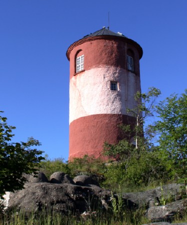
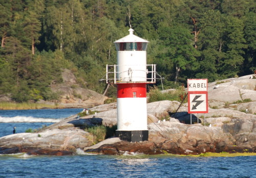
1768. Active only as a daybeacon. 12.5 m (41 ft) round cylindrical old-style stone tower with a conical roof. Tower painted red with a white horizontal band. Chris Goldberg's photo is at right, Irene Berg has a good photo, a 2020 photo is available, Huelse has a historic postcard view, and Google has a satellite view. This tower was never lit and served only as a daybeacon, a function it still performs. Until 1875 it also served as a pilot station. The tower was under restoration in 2021. Located atop a rocky bluff about midway on the west side of the island of Arholma. Site open, tower closed. . ARLHS SWE-085.
Arholma Nedre
1921 (station established 1883). Active; focal plane 9 m (30 ft); white light, 2 s on, 2 s off. 6 m (20 ft) round cylindrical concrete tower with lantern and gallery. Tower painted white, lantern red. Trabas has a photo and Google has a satellite view. The rear light is on a skeletal tower. Located on a promontory near the village of Arholma, on the west side of the island. Site open, tower closed. SV-2553; Admiralty C6370; NGA 10052.
Högskär
1915. Inactive since 1997. 9 m (30 ft) round cylindrical concrete tower with lantern and gallery, painted white. Huelse has a postcard photo taken in the 1960s and Google has a satellite view. Located on a skerry about 400 m (1/4 mi) off the northernmost point of Arholma. Accessible only by boat. Site open, tower closed. ARLHS SWE-195; ex-SV-2549; ex-Admiralty C6368.

Arholma Båk, Arholma, June 2009
Flickr Creative Commons photo by Chris Goldberg

Northeastern Stockholm Archipelago Lighthouses
Tjärven
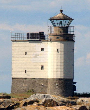
1903. Active; focal plane 18 m (59 ft); four flashes every 12 s, white or green depending on direction. 13 m (43 ft) round cylindrical concrete block tower attached to one corner of a square 3-story concrete block building. The ground floor is unpainted stone, and the upper portion of the lighthouse is painted white. Johan Walter's photo is at right, SFA has a page for the lighthouse, Trabas has a very distant view by Ronald Wöhrn, and Bing has a satellite view. The lighthouse formerly had a castellated gallery and a more traditional lantern. In 2008 the Sjöfartsverket restored the building and converted the light to solar power. The lantern was to be removed, but this proved to be more difficult than expected, so the new light was installed in the existing lantern instead. Located on a small island about 5 km (3 mi) northwest of the Söderarm lighthouse. Accessible only by boat. Site open, tower closed. ARLHS SWE-393; SV-2600; Admiralty C6386; NGA 9576.
Söderarm
1839. Inactive since 2007. 21 m (69 ft) round old-style granite tower with lantern and gallery. Lighthouse painted white with a red horizontal band; lantern and watch room painted black. 1-1/2 story wood keeper's house and other light station buildings. Björn Johansson's photo is at the top of this page, SFA has a page for the lighthouse, Ciprian Ionut Vlaicu has a 2021 photo, Huelse has a historic postcard view, and Google has a satellite view. The keeper's house is available for overnight accommodations. This lighthouse marked the beginning of the approach to Stockholm for westbound or southbound vessels. Located on a small island about 25 km (15 mi) east northeast of Kapellskär. Accessible only by boat. Site open, tower closed. Site manager: Söderarm Fyr . ARLHS SWE-059; ex-SV-2590; ex-Admiralty C6384; ex-NGA 9572.
#Remmargrund (1)
1970. Destroyed in 2018. This was a 20 m (66 ft) round cylindrical concrete tower with lantern and double gallery, painted with red and black horizontal bands. Wikimedia has a 2011 photo, another photo is available, Trabas has a very distant view, and Google has a satellite view. The lighthouse was destroyed in a collision with the ship Regal Star on 30 October 2018. It was replaced by a shorter skeletal tower mounted on the original base (focal plane about 12 m (39 ft); white, red or green light depending on direction, 8 s on, 2 s off). The lighthouse is the rear light of a range; the front light is on a short post. Located on a shoal about 3 km (2 mi) southeast of the island of Vattungarna. Accessible only by boat, but ferries to Finland pass close to the lighthouse. Site open, tower closed. ARLHS SWE-320; Active light: SV-2610; Admiralty C6387; NGA 9580.
Tjärvens Fyr
Tjärven Light, Åland Sea, July 2009
Wikimedia Creative Commons photo by Johan Walter
Lerskärsgrund
1970. Active; focal plane 12 m (39 ft); three flashes every 9 s, white, red or green depending on direction. 13 m (43 ft) round cylindrical concrete tower with lantern and double gallery, painted with red and black horizontal bands. Wikimedia has a photo, Trabas has a photo by Helmut Seger, another photo is available, and Google has a satellite view. Located on a shoal about 3 km (1.8 mi) east of the island of Fejan. Accessible only by boat, but ferries to Finland pass close to the lighthouse. Site open, tower closed. ARLHS SWE-235; SV-2618; Admiralty C6390; NGA 9588.
Västerkobb
1939. Active; focal plane 9 m (30 ft); white, red or green light depending on direction, 2 s on, 2 s off. 7.5 m (25 ft) round cylindrical concrete tower with lantern and gallery, painted white with a green horizontal band around the lantern. Wikimedia has the photo seen at right and Google has a satellite view. Located on the west side of the island of Vidinge. Accessible only by boat. Site open, tower closed. SV-2745; Admiralty C6396; NGA 9360.
Hundskärsknuv (Huvudskäsknuv)
1939. Active; focal plane 9 m (30 ft); flash every 3 s, white, red or green depending on direction. 8 m (26 ft) round cylindrical concrete tower with lantern and gallery, painted white with a red horizontal band around the lantern. Wikimedia has a photo and Google has a satellite view. Located on a skerry off the western tip of the island of Rödlöga. Accessible only by boat. Site open, tower closed. SV-2753; Admiralty C6399; NGA 9352.

Kapellskär Area Lighthouses
About 60 km (38 mi) northeast of Stockholm, Kapellskär is the terminal for ferries sailing for Mariehamn in the Åland Islands, for Naantali in Finland, and for Paldiski in Estonia.

Kapellskär (2)
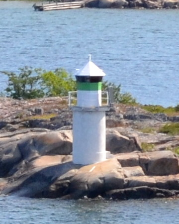
Date unknown (station established 1882). Active; focal plane 11 m (36 ft); four flashes every 12 s, white, red or green depending on direction. 10.5 m (31 ft) round concrete tower with lantern and gallery, painted white with a green horizontal band. Trabas has a photo by Helmut Seger, Huelse has a historic postcard view, and Google has a satellite view. Located on a skerry off the southeastern tip of Kapellskär island about 800 m (1/2 mi) east of the Kapellskär waterfront. Site open, tower closed. ARLHS SWE-210; SV-2635; Admiralty C6412; NGA 9608.
Marö Udde
1932. Active; focal plane 5 m (17 ft); flash every 5 s, white, red or green depending on direction. 5 m (17 ft) round cylindrical concrete tower with lantern and gallery. Tower painted red, lantern white with a red roof. Trabas has a photo and Google has a satellite view. Located at the northeastern point of Marö, an entry point for the northern channel to Stockholm, about 2 km (1.25 mi) southwest of Kapellskär. Accessible only by boat. Site open, tower closed. SV-2639; Admiralty C6416; NGA 9632.
Västerkobbs Fyr
Västerkobb Light, Vidinge, June 2011
Wikimedia Creative Commons photo by Johan Fredriksson

Yxlan Area Lighthouses
Yxlan is an island, 25 km (15 mi) long but quite narrow, lying on the south side of the main shipping channel between Stockholm and Finland.

Gryten
1947. Active; focal plane 6 m (20 ft); four flashes every 10 s, white, red or green depending on direction. 8 m (26 ft) round cylindrical concrete tower with lantern and gallery, painted white with a green horizontal band around the lantern. Wikimedia has a photo, Trabas has Helmut Seger's photo, and Google has a satellite view. Located in the center of the channel north of Yxlan. Accessible only by boat. Site open, tower closed. SV-2654; Admiralty C6421; NGA 9648.
Yxlan
Date unknown (station established 1905). Active; focal plane 7 m (23 ft); three flashes every 9 s, white, red or green depending on direction. 6 m (20 ft) round cylindrical concrete tower with lantern and gallery, painted white; lantern painted red with a white roof. Trabas has Jim Smith's photo, Wikimedia has a photo and Google has a satellite view. Located at the foot of a forested promontory on the southwest coast of the island of Yxlan. Probably accessible only by boat. Site open, tower closed. SV-2658; Admiralty C6422; NGA 9652.
Växlet Norra
Date unknown (station established 1881). Active; focal plane 7 m (23 ft); flash every 3 s, white, red or green depending on direction. 7 m (23 ft) round cylindrical concrete tower with lantern and gallery, painted white; lantern painted red with a white roof. Wikimedia has a photo, Trabas has Helmut Seger's photo, and Google has a satellite view. Located on a skerry in the channel west of the southwestern tip of Yxlan. Probably accessible only by boat. Site open, tower closed. SV-2666; Admiralty C6423; NGA 9656.

Österåker Lighthouses

Vallersvik
1931. Active; focal plane 7.5 m (25 ft); four flashes every 12 s, white, red or green depending on direction. 4 m (13 ft) octagonal lantern mounted on a concrete pad. Lantern painted white with a green horizontal band. Trabas has a closeup, Bengt Nyman has a photo, and Google has a satellite view. Located on a promontory on the north side of the channel about 1 km (0.6 mi) southwest of Bammarboda. Site status unknown. SV-2699; Admiralty C6444; NGA 9700.
Mjölkö (Mjölkön)
1931. Active; focal plane 4 m (13 ft); two flashes every 6 s, white, red or green depending on direction. 4 m (13 ft) octagonal lantern mounted on a concrete pier. Lantern painted green with a white roof; pier painted white. Trabas has Uwe Korn's photo, Carlo Pelagalli has a photo, and Google has a satellite view. Located on the west side of the channel southwest of Mjölkö. Accessible only by boat. Site open, tower closed. SV-2703; Admiralty C6446; NGA 9704.
Östra Ålgögrundet
Date unknown (station established 1931). Active; focal plane 6 m (20 ft); quick-flashing white light. 7.5 m (25 ft) octagonal tower with lantern and gallery, mounted on a round stone pier. Lighthouse painted white with a narrow green horizontal band. Carlo Pelagalli's photo is at right, Trabas has a photo, and Google has a satellite view. Located in the center of the channel southwest of Stora Algö. Accessible only by boat. Site open, tower closed. SV-2970; Admiralty C6452; NGA 9708.

Östra Ålgögrundet Light, Österåker, May 2008
ex-Panoramio Creative Commons photo by Carlo Pelagalli

Vaxholm Lighthouses

Sandgrundet (2)
1956 (station established 1922). Active; focal plane 4 m (13 ft); flash every 3 s, white, red or green depending on direction. 4 m (13 ft) lantern mounted on a stone pier. Trabas has a photo, Wikimedia has a photo, Claußen has a photo (2/3 the way down the page), Huelse has a postcard view and Google has an indistinct satellite view. Located about 700 m (0.45 mi) southeast of the Vaxholm waterfront. Accessible only by boat. Site open, tower closed. ARLHS SWE-333; SV-3004; Admiralty C6528; NGA 9472.
Brödstycket
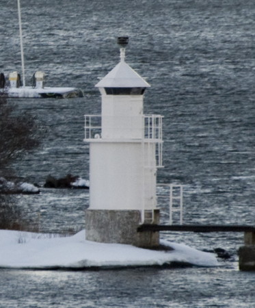
Date unknown (station established 1882). Active; focal plane 6 m (20 ft); flash every 3 s, white, red or green depending on direction. 6 m (20 ft) round cylindrical tower with lantern and gallery, painted white with a narrow red horizontal band. Dick Rochester's photo is at right, Bengt Nyman has a closeup photo, Trabas has Uwe Korn's photo, and Google has an indistinct satellite view. This light is at the point where the northern and southern approaches to Stockholm converge. Located on a small island in the center of the channel about 1200 m (3/4 mi) north of Skarpö. Accessible only by boat. Site open, tower closed. SV-2995; Admiralty C6524; NGA 9460.
Tynningö
1978 (station established 1919). Active; focal plane 5 m (17 ft); two flashes every 6 s, white, red or green depending on direction. 6 m (20 ft) round cylindrical tower with lantern and gallery, painted white. Wikimedia has Carlo Pelagalli's photo, Trabas has a photo, and Google has an indistinct satellite view. Located in the channel off the south coast of Tynningö. Accessible only by boat. Site open, tower closed. SV-3028; Admiralty C6570; NGA 9496.
Brödstyctets Fyr
Brödstycket Light, Vaxholm, July 2008
Wikimedia Creative Commons photo by Dick Rochester
Värmdö-Garpen (2)
1970 (station established 1883). Active; focal plane 4 m (13 ft); white, red or green light depending on direction, occulting once every 5 s. 5 m (17 ft) round cylindrical tower with lantern and gallery, painted white. Wikimedia has a photo, Trabas has a photo, and Google has a distant satellite view. Located on the north side of the island of Kungsbor, about 800 m (1/2 mi) east northeast of Koviksudde. Accessible only by boat. Site status unknown. SV-3040; Admiralty C6568; NGA 9484.
Furuholmen (2)
1957 (station established 1895). Active; focal plane 5 m (17 ft); flash every 3 s, white, red or green depending on direction. 5 m (17 ft) round cylindrical tower with lantern and gallery, painted white. Trabas has a photo, Claußen has a photo (halfway down the page), and Google has a satellite view. Located at the west end of a small island about 1 km (0.6 mi) south of Karlsudd. Accessible only by boat. Site open, tower closed. SV-3010; Admiralty C6544; NGA 9476.
Bogesund (2)
1959 (station established 1926). Active; focal plane 4 m (13 ft); two flashes every 6 s, white, red or green depending on direction. 4 m (13 ft) round stone pier with lantern and gallery. Lantern painted green. Bosse Arnholm has a closeup photo, Trabas has a closeup, Wikimedia has a photo, Claußen has a photo (2/3 the way down the page), and Google has a satellite view. Located in the channel south of Karlsudd. Accessible only by boat. Site open, tower closed. SV-3032; Admiralty C6536; NGA 9504.

Furuholmen Light, Vaxholm, May 2008
ex-Panoramio Creative Commons photo by Carlo Pelagalli

Stockholm Urban Area Lighthouses and Lightships

Lidingö Lighthouses
Elfviksgrund (Ålvviksgrundet)
Date unknown. Active; focal plane 6.5 m (21 ft); white, red or green light, depending on direction, 3 s on, 3 s off. 8 m (26 ft) round cylindrical tower with lantern and gallery, painted white with one green horizontal band. Wikimedia has Dick Rochester's photo, Trabas has a photo, Claußen has a photo (fourth photo on the page), and Google has a satellite view. Located off Elfviksudde, the eastern point of Lidingö. Accessible only by boat. Site open, tower closed. SV-3068; Admiralty C6546; NGA 9520.
Libertus
Date unknown (station established 1931). Active; focal plane 6 m (20 ft); three flashes every 9 s, white, red or green depending on direction. 7 m (23 ft) round concrete tower with lantern and gallery, painted white. A photo is at right, Lars Johnson has a closeup, Trabas has Rainer Arndt's photo, Claußen has a photo (second photo on the page), Vladas Portapas has a photo, and Google has a satellite view. This lighthouse displays a directional light for vessels westbound for Stockholm. Located at the northwest tip of a small island in the Lilla Värtan sound, near a junction point for several ship channels and about 1.4 km (0.9 mi) northeast of the Blockhusudden light (see below). Accessible only by boat. Site open, tower closed. SV-3009; Admiralty C6550; NGA 9548.
* Torsvik
1950. Inactive since 1980. 6 m (20 ft) round cylindrical tower with lantern and gallery, painted white. Wikimedia has a photo but trees partially block the view of the light in Google's street view and satellite view. Located on the west side of the island of Lidingö a short distance north of the bridge connecting the island to Stockholm. Site open, tower closed. ex-SV-3061; ex-Admiralty C6555.

Danderyds Lighthouses
* Djursholmsudde
1950. Active; focal plane 5 m (17 ft); four flashes every 12 s, white, red or green depending on direction. 5 m (17 ft) round cylindrical tower with lantern, painted white. The lantern gives this light an odd, mushroom-shaped appearance. Trabas has a photo and Google has a satellite view. Djursholm is an upscale neighborhood in Danderyds about 5 km (3 mi) north of downtown Stockholm. Located at the southeastern tip of a promontory pointing into the Stora Värtan sound. Site open, tower closed. SV-3049; Admiralty C6541; NGA 9532.
* Aludden
1950. Active; focal plane 5 m (17 ft); two flashes every 6 s, white, red or green depending on direction. 5 m (17 ft) round cylindrical tower with lantern, painted white. Similar to its sibling, the Djursholmsudde light (previous entry). Trabas has a photo, Peter Lind has a street view, and Google has a satellite view. Located at the southeastern tip of a promontory in Djursholm, about 800 m (1/2 mi) southwest of the Djursholmsudde light. Site open, tower closed. SV-3053; Admiralty C6542; NGA 9536.
Libertus Fyr
Libertus Light, Lidingö, January 2011
Wikimedia Creative Commons photo by Pgjansson

Stockholm City Lighthouses and Lightships
* Kaknästornet
Date unknown (tower built 1967). Active; focal plane 172 m (564 ft); quick-flashing white light; the tower also carries an aeronautical quick-flashing white light and red aircraft warning lights. 155 m (509 ft) square concrete television and communications tower. Trabas has a photo and Google has a satellite view, but the tower is blurred out in Google's street view. Designed by architect Bengt Lindroos, this tower is a famous landmark on the east side of Stockholm. The top of the tower formerly included a popular restaurant offering a magnificent view of the city and its surroundings but it was closed in 2018 due to safety and security concerns. Although the navigational value of the light is questionable, it has long been carried on the Admiralty list. Located in the Kaknäs neighborhood east of Stockholm and north of Djurgården. Site and tower open. Admiralty C6548.
* Blockhusudden (Djurgården)
Date unknown (station established 1905). Active; focal plane 6 m (20 ft); two flashes every 6 s, white, red or green depending on direction. 7 m (23 ft) round stone tower with lantern and gallery, mounted on a round stone pier. The tower is unpainted dark gray stone, lantern painted white. Trabas has a closeup photo, Wikimedia has a photo, Lars Johnson has a fine closeup, Claußen has a photo (first photo on the page), Huelse has a historic postcard view, and Google has a street view and a satellite view.This lighthouse marks the entrance to the Saltsjön, Stockholm's inner harbor. Located off the east end of the Djurgården, the forested island just east of downtown Stockholm. Accessible only by boat, but there are excellent views from shore. Site open, tower closed. SV-3125; Admiralty C6558; NGA 9556.
* Fyrskepp 21 Biskopsudden (Trelleborgsredd)
1899 (Kockums Mekaniska Verkstad, Malmö). Decommissioned 1962. 24 m (79 ft) steel lightship. The vessel has been altered considerably from its original appearance; it has a modern superstructure and a faux light tower with a round observation room. Hull painted red, superstructure white with red trim, light tower white with a red roof. SFA has a page for the lightship, a good closeup photo is available as well as a wider view, and Google has a street view and a satellite view. The ship served the Trelleborgsredd station until 1930 and then the Oskarsgrundet station from 1932 until 1961. Its location thereafter is not known, but in 1988 the ship was rebuilt as a houseboat and office. The original light tower was removed and sold to the owners of the lightship Västra Banken, which has since been relocated to the Le Phare Bleu Marina and Resort in Grenada, in the West Indies. Since 1988 Fyrskepp 21 has been called the Biskopsudden, because it is moored at the marina of the same name. In 2006 the ship was for sale for £1 million. It reopened as a place for meetings, events, and parties. In 2021 it was under new management and renovation. Moored at the Biskopsudden Marina on the south side of the Djurgården; ferries arriving in or departing Stockholm pass the vessel. Site open, vessel closed. Owner/site manager: Fyrskeppet Biskopsudden. ARLHS SWE-442.
**** Fyrskepp 25 Finngrundet
1903 (Gefle Mekaniska Verkstad AB). Decommissioned 1969. 31 m (102 ft) two-masted steel lightship; light tower with lantern and gallery. Ship painted red with white trim; superstructure painted a pale yellow. Henrik Ismarker's photo at right, SFA has a page for the lightship, Wikimedia has several photos, and Google has a street view. The ship is missing from Google's current satellite view: it may have been relocated for maintenance. This ship served its entire career, 66 years, assigned to the Finngrundet station northeast of Gavö. In 1970 it was donated by the Sjöfartsverket to the Statens Sjöhistoriska Museet (National Maritime History Museum), better known as the Vasa Museum, where it has been on display ever since. Moored at the museum, at the western end of the Djurgården. Site open, vessel open for tours daily except Mondays. Owner/site manager: Sjöhistoriska Museet (Lightship Finngrundet ). ARLHS SWE-043.

Fyrskepp 25 Finngrundet, Stockholm, July 2007
Flickr Creative Commons photo by Henrik Ismarker
* Fyrskepp 10B Fladen
1892 (Kockums Mekaniska Verkstad, Malmö). Decommissioned 1967. 34.6 m (113 ft) two-masted steel lightship; light tower with lantern and gallery. Hull and light tower painted red, superstructure white. Larry Myhre has a 2008 photo, Andreas Wallner has a 2022 street view, and Google has a satellite view. The ship served on the Fladen station for all of its career except 1909-1929, when it was on the Grisbådarna station. In 1968 it was sold and converted to a club fishing ship. In 1987 the club sold the ship to the film director Hannes Holm. In 2010 it was sold a third time. The new owner restored the vessel and has it back in running condition. Moored at the northern tip of Skeppsholmen, an island in Stockholm's harbor. Site open, vessel closed. Owner/site manager: private. ARLHS SWE-044.
Fyrskepp 32 Vinga (ex-Fladen) (?)
1926 (Hälsingborgs Varvs och Stål Svetsnings AB). Decommissioned 1972 and possibly scrapped. 34.6 m (113 ft) steel lightship; the light tower has been removed. Hull painted red, superstructure buff. Larry Myhre has a 2008 photo. The ship served on the Fladen station for three years and then for many years on the Vinga station in the Skagerrak. In 1967 it was rebuilt to serve as a residential ship for hydrographic survey expeditions. In 1978 it was sold to the Skeppsholmsgården Foundation, which continued its use as a residential ship, this time for high school students. Since 2007 it has been for sale; there was concern that if it was not sold soon it would be scrapped. Formerly moored at Skeppsholmen, a short distance southeast of the Fladen, but missing now from Google's satellite view of its former location. Site status unknown. Site manager: unknown. ARLHS SWE-255.

Nacka Lighthouses
* Järlasjön
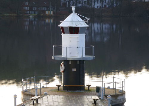
1927. Active (privately maintained and unofficial); focal plane about 5 m (17 ft); light characteristics unknown. 5 m (17 ft) round concrete tower with lantern and gallery. Tower painted black, lantern white. Holger Ellgaard's photo is at right, Hans Hallgren has a 2021 photo, Kicki Holmén has a nice view, Cédric Volant has a 2021 drone view, and Google has a satellite view. The Järlasjön is a lake in the Nacka municipality on the southeast side of Stockholm. The lake is connected by a narrow strait to another lake, the Sicklasjön, which is in turn connected to Stockholm harbor by the Sickla Canal. Located at the end of a pier on the north side of the lake. Accessible by walking the pier. Site open, tower closed.

Järlasjön Light, December 2013
Wikimedia Creative Commons photo by Holger Ellgaard
Kungshamn
Date unknown (station established 1905). Active; focal plane 7 m (23 ft); flash every 3 s, white, red or green depending on direction. 4 m (13 ft) octagonal lantern, painted white. Trabas has a closeup and Google has a satellite view. The light marks the entrance to the Skurusund, a north-south channel intersecting the main channel to Stockholm. Located on the south side of the main channel and the west side of the Skurusund. Site status unknown. SV-3075; Admiralty C6549; NGA 9528.

Information available on lost lighthouses:

Notable faux lighthouses:

Adjoining pages: North: Southern Bothnia | East: Åland Islands | South: Värmdö to Nynäshamn | West: Lake Mälaren

Return to the Lighthouse Directory index | Ratings key

Posted July 16, 2007. Checked and revised November 28, 2023. Lighthouses: 42; Lightships: 4. Site copyright 2023 Russ Rowlett and the University of North Carolina at Chapel Hill.