Lighthouses of Uruguay

The Oriental Republic of Uruguay is a relatively small country of South America, located south of Brazil and north of Argentina. As a border zone between the Portuguese settlements to the north and the Spanish settlements to the south the area of Uruguay (known then as the Banda Oriental) was sought first by Portugal and Spain and later by their successors Brazil and Argentina. Following nearly three years of the Cisplatine War between Brazil and Argentina the Treaty of Montevideo, signed in August 1828 through British mediation, established Uruguay as an independent nation.

Starting on the South Atlantic Ocean at the Brazilian border the coastline of Uruguay curves gradually westward along the northern side of the great Río de la Plata embayment and estuary. Ship traffic is heavy along this coast, so to guard it a series of handsome masonry lighthouses were built during the late 1800s and early 1900s. These lighthouses remain in service, many of them still staffed. Seven of them are readily accessible along the well-populated coast and five are open for climbing every day of the year.

Uruguay is divided into nineteen departments (departamentos).

The Spanish word for a lighthouse is faro; a smaller light is often called a farola or a baliza (beacon). In Spanish isla is an island, cabo is a cape, punta is a promontory or point of land, péñon is a rock, arrecife is a reef, bahía is a bay, ría is an estuary or inlet, estrecho is a strait, río is a river, and puerto is a port or harbor.

Active lighthouses in Uruguay are owned by the navy (Armada Nacional de Uruguay) and maintained by the Departamento de Ayudas a la Navegación.

ARLHS numbers are from the ARLHS World List of Lights. UY numbers are from Uruguay's Lista de Faros. Admiralty numbers are from volume G of the Admiralty List of Lights & Fog Signals. U.S. NGA List numbers are from Publication 110.

General Sources
Online List of Lights - Uruguay
Photos by various photographers posted by Alexander Trabas.
Leuchttürme in Uruguay
Photos by Andreas Köhler.
Lighthouses in Uruguay
Photos by various photographers available from Wikimedia.
World of Lighthouses - Uruguay
Photos by various photographers available from Lightphotos.net.
Leuchttürme Südamerikas auf historischen Postkarten
Historic postcard views posted by Klaus Huelse.
Navionics Charts
Navigation chart for Uruguay.


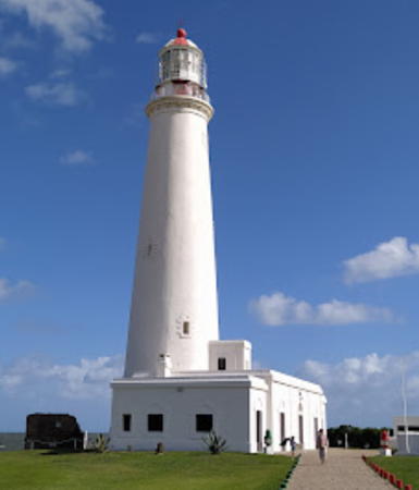
Cabo Santa Maria Light, La Paloma, September 2013
Wikimedia Creative Commons photo
by CaranchoFlor

Rocha Department (Atlantic Coast) Lighthouses
* [Monumento Artigas (Sandra)]
Date unknown. Active; focal plane 15 m (49 ft); white flash every 5 s. Approx. 3 m (10 ft) square white concrete pillar attached to a second pillar carrying a statue of Gen. José Gervasio Artigas, the hero of Uruguay's struggle for independence from Spain. Alex Morena has a closeup photo, Marcelo Campi has a second photo, Vinicius de Oliveira has a street view, and Google has a satellite view. Located on a rocky promontory about 3 km (2 mi) northeast of the Punta Palmar lighthouse (next entry). Site open. ARLHS URU-020; UY-022; Admiralty G0658; NGA 19016.
Punta Palmar (Punta del Diablo) (2)
1984 (station established 1977). Active; focal plane 21 m (69 ft); white flash every 6 s. 12 m (39 ft) round barbell-shaped fiberglass tower painted with red and white horizontal bands. No lantern. Silvia Lescano has a 2017 closeup photo, Wikimedia has Vince Alongi's photo, Marcelo Filho has a 2020 photo, Gerardo Silva has a street view, and Google has a satellite view. This light replaced a 10 m (33 ft) skeletal tower that proved unsatisfactory. Located off national route 9 about 40 km (25 mi) northeast of Castillos. Site and tower closed (surrounded by private property). . ARLHS URU-013; UY-025; Admiralty G0660; NGA 19020.
*** Cabo Polonio
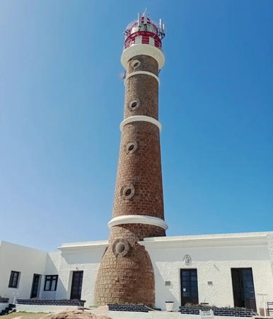
1881. Active; focal plane 40 m (131 ft); white flash every 12 s. 26 m (85 ft) round brick tower with lantern and double gallery rising from 1-story keeper's house. Tower unpainted except for three narrow white horizontal bands; lantern and watch room painted with red and white vertical stripes. Sibling of the 1877 Faro José Ignacio (see below). Wikimedia has several photos including the one at right, another good photo is available, Köhler has a nice view, Trabas has Köhler's photo, Diana Píriz has a 2022 photo, and Google has a fine satellite view and a street view from the beach. This light station is staffed. The lighthouse marks a rocky point in an otherwise sandy area; nearby offshore are several islands with colonies of seals. The area was declared a national monument in 1976. There's no public road access, but the light can be reached by hiking on the beach from nearby resorts. Guided tours are available. Located off national route 9 about 25 km (15 mi) south of Castillos. Site open; tower open 10 am to 1 pm and 3-5 pm daily. Site manager: Monumento Nacional de Dunas. . ARLHS URU-005; UY-028; Admiralty G0662; NGA 19024.
* [Maria Victoria]
Date unknown. Active; focal plane 7 m (23 ft); flash every 4 s, white or red depending on direction. 7 m (23 ft) square skeletal tower with gallery and an enclosed upper section, painted with red and white horizontal bands. Alejandro Eguía has a closeup photo and Google has a street view and a satellite view. This light guides vessels entering a small harbor on the north side of Cabo Santa María. Located on the beach about 3 km (2 mi) north of the Faro de la Paloma (next entry). Site open, tower closed. UY-037; Admiralty G0664; NGA 19028.
Faro de Cabo Polonio
Cabo Polonio Light, Castillos, January 2009
Wikimedia Creative Commons photo by Georgez
* [Maria Magdalena]
Date unknown. Active; focal plane 14 m (46 ft); green flash every 5 s. 7.5 m (25 ft) square skeletal tower painted green. Julio Cesar Bonjour Rivas has a closeup photo and Alejandro Novoa has a closeup street view, but the small tower is hard to see in Google's satellite view. Located on the breakwater of the Cabo Santa Maria harbor. Accessible with caution by walking the pier. Site open, tower closed. UY-040; Admiralty G0667; NGA 19030.
*** Cabo Santa María (La Paloma)
1874. Active; focal plane 42 m (137 ft); white flash every 60 s. 20 m (98 ft) round brick tower with lantern and gallery rising from a 1-story keeper's house. Tower painted white; lantern and watch room painted with red and white vertical stripes. This is a staffed station. A photo is at the top of this page, Ingo Wilges has a good 2008 photo, Köhler has a closeup, Trabas has Köhler's photo, Wikimedia has several photos, Huelse has a historic postcard view, and Google has a street view from the beach and a satellite view. The light station was declared a national historic monument in 1976. Located on the cape in the seaside resort of La Paloma, at the end of national route 15. Site open; tower open for climbing 3 pm to 15 minutes before sunset daily and also 10 am to 1 pm daily except Monday. . ARLHS URU-004; UY-043; Admiralty G0668; NGA 19032.

Maldonado Department (Punta del Este Area) Lighthouses
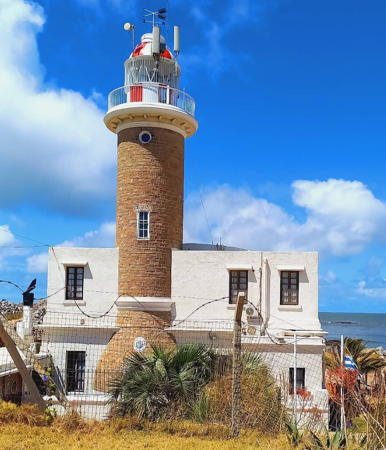
*** Punta José Ignacio
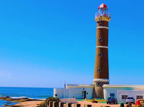
1877. Active; focal plane 32 m (105 ft); white flash every 2 s. 25 m (82 ft) round brick tower with lantern and gallery rising from 1-story keeper's house. Tower unpainted except for three narrow white horizontal bands; lantern and watch room painted with red and white vertical stripes. Light station is staffed. Sergio Amosar has a good photo, Matt Rubens has a nice photo, Köhler has a photo, Trabas has Köhler's photo, Wikimedia has several photos, and Google has a street view and a satellite view. Located on a rocky point in a popular resort area on the coastal road (national route 10) about 55 km (35 mi) southwest of La Paloma. Site open, tower open in the afternoon daily in the summer and on Saturday and Sunday evenings the rest of the year. . ARLHS URU-006; UY-046; Admiralty G0672; NGA 19036.

Punta José Ignacio Light, José Ignacio, May 2014
Wikimedia Creative Commons photo by Casaseneleste
Isla de Lobos (2)
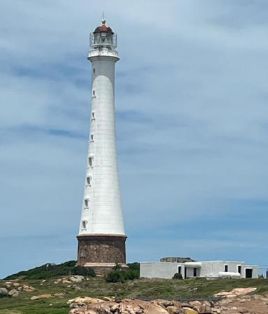
1906 (station established 1858). Active; focal plane 66 m (217 ft); white flash every 5 s; the tower also carries a continuous red light at a focal plane of 53 m (174 ft). 59 m (194 ft) round tapered concrete block tower with lantern and gallery, mounted on a round stone base. Lighthouse painted white; base unpainted; lantern and watch room painted with red and white vertical stripes. Priscilla Jordão's photo is at right, a closeup photo (misidentified as "Punta Ballena") is available, Julieta Zubiri has a view from the sea, Trabas has a photo by Capt. Theo Hinrichs, Wikimedia has photos, Huelse has a historic postcard view, and Google has a satellite view. The light station is staffed. Uruguay's tallest lighthouse, this is also one of the tallest concrete lighthouses in the world. The 1858 lighthouse was short-lived: sealers protested that it scared away the animals, so the light was moved to Punta del Este in 1860. The 1906 tower was designed by Victor Benavídez and built by José María Claret. Located on a small (36 ha, 90 acre) island about 13 km (8 mi) southeast of Punta del Este. Accessible only by boat. Site and tower closed (the island is a wildlife sanctuary protecting a huge colony of seals). Site manager: Reserva Natural Isla de Lobos. . ARLHS URU-002; UY-060; Admiralty G0676; NGA 19040.
* Punta del Este (Bahía de Maldonado)
1860. Active; focal plane 44 m (144 ft); white flash every 8 s. 25 m (82 ft) round brick tower with lantern and gallery rising from a 1-story keeper's house. Tower unpainted; lantern painted white with a red-and-white striped roof. Köhler has a photo, Trabas also has Köhler's photo, Valery Bespalko has a 2019 photo, Lightphotos.net has a photo, and Google has a street view and a satellite view. The light station is staffed. The lighthouse was refurbished in 1923, but it was not replaced as some sources state. The narrow peninsula of Punta del Este is the southernmost point of Uruguay; it encloses the east side of the Bahía de Maldonado and is the extreme eastern end of the Río de la Plata embayment and estuary. Located on the Plaza del Faro near the end of the peninsula in the popular resort city of Punta del Este. Site open, tower closed. . ARLHS URU-008; UY-073; Admiralty G0682; NGA 19044.
* [Punta del Este West Breakwater (Suky)]
Date unknown. Active; focal plane 7.5 m (25 ft) (?); red flash every 5 s. 8 m (26 ft) square pyramidal skeletal tower with gallery, painted red. Trabas has Jim Smith's closeup photo, Luciano Alonso has a closeup street view and Google has a sea view and a satellite view. Located at the end of the breakwater of Punta del Este; accessible by walking the pier. Site open, tower closed. ARLHS URU-025; UY-082; Admiralty G0684; NGA 19048.

Isla de Lobos Light, Punta del Este, November 2007
Flickr Creative Commons photo by Priscilla Jordão
Isla Gorriti
Date unknown. Active; focal plane 9 m (30 ft); green flash every 5 s. 5 m (17 ft) post attached to a 1-story square concrete equipment shelter. Lighthouse painted with black and white horizontal bands. Alejandro Novoa has a street view, Trabas has Jim Smith's photo, and Google has a satellite view. Isla Gorriti is an island about 1.7 km (1 mi) long, lying about 1.6 km (1 mi) west of Punta del Este. The island is a nature reserve but visitors are permitted. Located on the southeastern corner of the island, near a fort that defended the island unsuccessfully against a British attack in 1806. Accessible only by boat. Site open, tower closed. UY-088; Admiralty G0683; NGA 19056.
* [Punta Negra (Punta Colorada)]
Date unknown. Active; focal plane 17 m (56 ft); white flash every 5 s. Approx. 11 m (36 ft) square skeletal tower, painted with black and white horizontal bands. Carlos Vila has a good photo and Google has a street view and a satellite view. Located in the median of a street about 5 km (3 mi) southeast of Piriapolis. Site open, tower closed. ARLHS URU-015; UY-097; Admiralty G0688; NGA 19068.
* #[Piriápolis Outer Breakwater) (1)]
Date unknown. Replaced. This was an 8.5 m (28 ft) square skeletal tower, painted red. Christian Lima has a street view and Google has a satellite view. Maximiliano Pereira's 2018 street view shows that the light (focal plane 10 m (33 ft); red flash every 5 s) is now on a red post. Located on the east (outer) breakwater at Piriápolis. Accessible by walking the pier. Site open, tower closed. Active light: UY-100; Admiralty G0689.1; NGA 19076.
* [Piriápolis Inner Breakwater)]
Date unknown. Active; focal plane 10 m (33 ft); green flash every 5 s. 8.5 m (28 ft) square skeletal tower, painted green. Maximiliano Pereira has a distant street view and Google has a satellite view. Located on the north (inner) breakwater at Piriápolis. Accessible by walking the pier. Site open, tower closed. UY-101; Admiralty G0689.2; NGA 19076.5.

Montevideo Department Lighthouses
Montevideo is the capital and by far the largest city and most important port of Uruguay. Its population, approaching 2 million, is roughly a third of the population of the country.

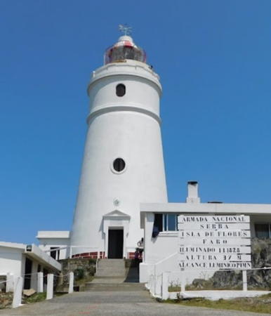
Isla de Flores
1828 (designed by Francisco Antonio Raposo). Active; focal plane 37 m (121 ft); two white flashes, separated by 4 s, every 16 s. 19 m (64 ft) round old-style brick tower with lantern and gallery attached to a 1-story keeper's house. Tower painted white; lantern and watch room painted with red and white vertical stripes. A photo is at right, a 2007 photo is available, Trabas has a distant view by Rainer Arndt, Wikimedia has many photos, Luciano Mende has a 2022 photo, Huelse has a historic postcard view, and Google has a street view and a satellite view. Findlay's 1879 list has 1833 as the station establishment date. The height of the lighthouse was increased in 1911 (after Huelse's postcard view). The light station is staffed. The island is about 12 km (7 mi) offshore in the Río de la Plata and about 32 km (20 mi) east of Montevideo. It is a historic site, having been used formerly as a slave reception station and as a sanitorium; today the light station is the only activity. Located on the highest point of the island. Accessible only by boat. Site and tower closed. . ARLHS URU-001; UY-115; Admiralty G0690; NGA 19080.

Isla de Flores Light, Montevideo, December 2010
Wikimedia Creative Commons photo by Rossini
* [Puerto del Buceo East Breakwater]
Date unknown. Active; focal plane 7.5 m (25 ft); red flash every 5 s. 8 m (26 ft) square skeletal tower painted red. Trabas has a photo by Hendrik Martin Porath and Google has a satellite view. Located at the end of the east breakwater of Puerto del Buceo. Site open, tower closed. ARLHS URU-018; UY-139; Admiralty G0698; NGA 19108.
* Yacht Club Uruguayo (Puerto del Buceo)
1939. Active; focal plane 40 m (131 ft); white flash every 5 s. Light mounted atop an 8-story Art Deco concrete and steel building. Entire building is white. Manilo Ferrari has a good photo, Köhler has a photo, Trabas has Köhler's photo, and Google has a street view and a satellite view. The building was listed as a historic site in 1997. Located at the Puerto del Budeo on the east side of Montevideo. Site open. Site manager: Yacht Club Uruguayo. ARLHS URU-019; UY-145; Admiralty G0699; NGA 19112.
* [Puerto del Buceo West Breakwater]
Date unknown. Active; focal plane 13 m (43 ft); green flash every 5 s. 8 m (26 ft) square skeletal tower painted green. Trabas has a photo by Hendrik Martin Porath, Lighthouse Digest has Nancy Rau's photo, and Google has a street view and a satellite view. Located at the end of the main breakwater of Puerto del Buceo. Site open, tower closed. ARLHS URU-014; UY-142; Admiralty G0696; NGA 19104.
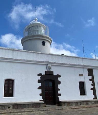
*** Punta Brava (Punta Carretas)
1876. Active; focal plane 21 m (69 ft); flash every 5 s, alternating red and white. 19 m (63 ft) round cylindrical brick tower with lantern and gallery, rising from a 2-story keeper's house. Tower unpainted; lantern and watch room painted with red and white vertical stripes; keeper's house painted white. The house is wrapped around the tower in an unusual way. Vince Alongi has a photo, Köhler has a good photo, Trabas has Erich Hartmann's photo, Wikimedia has several excellent photos, Julio Couto has a panoramic view from the gallery, Huelse has a historic postcard view, and Google has a street view and a satellite view. The second story was added to the keeper's house in 1911. The light station is staffed. Located at the end of a very sharp point on the southeastern side of the city of Montevideo, Uruguay's capital. Site open, tower open 11 am to 6 pm daily. . ARLHS URU-012; UY-151; Admiralty G0700; NGA 19124.
Punta Brava Light
Punta Brava Light, Montevideo, February 2012
Wikimedia Creative Commons photo by Diode
* Montevideo Catedral Metropolitana
1862. Inactive since about 1910. Approx. 23 m (75 ft) square masonry church tower, the south tower of the 1790 Metropolitan Cathedral in downtown Montevideo. Nikolaus Werner has a good photo, Köhler has a photo of the cathedral, and Google has a closeup street view and a good satellite view. Findlay's 1879 list has 1864 as the station establishment date. The light was removed after mariners complained it was difficult to distinguish from other lights of the city. Located in the old part of the city, which is on a peninsula jutting into the Río de la Plata. Site open, tower closed.
* Escollera Sarandí (Montevideo East Breakwater)
Date unknown. Active; focal plane 22 m (72 ft); red flash every 3 s. 12 m (39 ft) post centered on an octagonal stone and concrete fortification. Trabas has a photo by Erich Hartmann, and Google has a street view and a satellite view. Located at the end of the breakwater at the entrance to Montevideo harbor. Accessible by walking the pier, which is popular with fishermen. Site open, the old fort may be open, tower closed. ARLHS URU-021; UY-313; Admiralty G0704; NGA 19136.
** El Cerro de Montevideo (Fortaleza General Artigas, Fortaleza del Cerro)
1802. Active; focal plane 148 m (486 ft); three white flashes, separated by 2 s, every 10 s. 8 m (26 ft) round cylindrical brick tower with lantern and gallery rising from a historic fortress. Entire lighthouse painted white. The light station is staffed. Trabas has Köhler's photo seen at right, Wikimedia has photos, a 2022 photo is available, Raul Sinedino has a closeup street view, Huelse has a historic postcard view, and Google has a satellite view. This is Uruguay's oldest lighthouse, built by Spain before Uruguay became independent. Restored during the 1930s, the fortress reopened in 1939 as Uruguay's military museum, the Museo Militar Fortaleza General Artigas. The light has very little navigational value today, but it is maintained for historic continuity. Located atop the hill (cerro) for which the city is named, but across the harbor (west) from the main part of the modern city. Site open, museum open daily, tower closed so far as is known. . ARLHS URU-009; UY-424; Admiralty G0702; NGA 19184.

Cerro de Montevideo Light, Montevideoo, February 2009
photo copyright Andreas Köhler; used by permission
Piedra del Arriero
Date unknown. Active; focal plane 9 m (30 ft0; red flash every 5 s. 9 m (30 ft) red tower on a square base. No photo available but Bing has a satellite view. Located at the end of a shoal marking the entrance to the Río Santa Lucía on the west side of Montevideo. Accessible only by boat. Site open, tower closed. Admiralty G0740; NGA 19200.
La Penela (2)
1984 (station established 1915; lightship station established 1866). Active; focal plane 17 m (56 ft); four white flashes every 10 s. 14 m (46 ft) round "barbell" fiberglass tower, flared at top and bottom, mounted on the circular caisson of the 1915 lighthouse. Lighthouse painted with red and white horizontal bands. No lantern. Two photos are available and Bing has a satellite view. Huelse has a postage stamp image of the original lighthouse, which had a round light tower centered on a square keeper's quarters. Located in the Río de la Plata about 10 km (6 mi) west of Cerro de Montevideo. Accessible only by boat. Site and tower closed. ARLHS URU-011; UY-445; Admiralty G0736; NGA 19196.

Colonia Department Lighthouses
Puerto Saucé Breakwater
Date unknown. Active; focal plane 6 m (20 ft0; red flash every 5 s. 6 m (20 ft) square red skeletal tower with lantern and gallery. Trabas has a photo by Hendrik Martin Porath, Gerardo Ruske has a distant view along the breakwater, and Google has a satellite view. Located at the end of the breakwater sheltering the harbor of Juan Lacaze. Accessible only by boat (the breakwater is not walkable). Site open, tower closed. Admiralty G0748; NGA 19240.
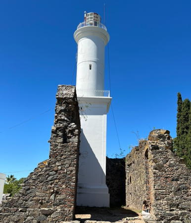
*** Colonia del Sacramento
1857. Active; focal plane 34 m (112 ft); red flash every 9 s. 27 m (88 ft) cylindrical brick tower with lantern and gallery, lower half square, upper half round. Lighthouse painted white; lantern painted with red and white vertical stripes. Ignacio Errico's photo is above right, Trabas has a similar photo by Alfonso Biescas Vignau, an excellent closeup is available, Wikimedia has numerous photos, Sidnei José Romano has a street view, Huelse has a historic postcard view, and Google has a satellite view. The light station is staffed. The lighthouse is built within the ruins of the Convento de San Francisco Javier, built by Portugal in 1682. Construction of the lighthouse began in 1845 but it was interrupted by a prolonged civil war, the Guerra Grande, which finally ended in 1852. Adjacent to the light station is the municipal museum of this historic city, which faces Buenos Aires across the broad Río de la Plata estuary. Located in the historic district of the city, on a peninsula extending into the Río de la Plata. Site open; tower open 10 am to 12:30 pm and 2:30 pm to 6:30 pm daily. . ARLHS URU-007; UY-595; Admiralty G0756; NGA 19260.
Isla de Farallón
1876. Active; focal plane 26 m (86 ft); two white flashes, separated by 2.5 s, every 10 s. 24 m (79 ft) round brick tower with lantern rising from 1-story keeper's house. Tower painted white; lantern and watch room painted with red and white vertical stripes. Capt. Theo Hinrichs's photo is above right, Trabas has Capt. Peter Mosselberger's photo, Gonzalo Sainz-Trápaga has a distant view that shows the lighthouse in action, Oscar Esteban Fernandez Campos has a view from the sea, the lighthouse also appears on a postage stamp, Lighthouse Digest has a historic postcard view contributed by Miguel Garcia, and Google has a satellite view. This is an automated lighthouse; the keeper's house is abandoned and probably endangered. Located on a tiny island in the Río de la Plata about 5 km (3 mi) west southwest of Colonia del Sacramento. Accessible only by boat (and the island is said to be infested with poisonous snakes). Site and tower closed. ARLHS URU-003; UY-610; Admiralty G0762; NGA 19280.
Piedra Diamante
Date unknown. Active; focal plane 18 m (59 ft); two long white flashes every 6 s. 18 m (59 ft) round tapered concrete tower with lantern, painted yellow. Trabas has Capt. Peter Mosselberger's photo and Bing has a satellite view showing the lighthouse to be precisely on the international border. Despite its proximity to the Uruguay coast this lighthouse was built by Argentina. A note is needed here. Under a 1973 treaty this lighthouse stands in "shared waters," where Argentina and Uruguay share jurisdiction. The treaty provides that both countries may build and maintain navigational aids in shared waters. Argentina maintains navigational aids in this area, very close to the coast of Uruguay, because the shipping channel leads to Argentine ports on the Río Uruguay and Río Paraná. Uruguay owns the economic rights to the seabed under the lighthouse and if future sedimentation should bring the shoal to the surface the resulting island would be Uruguayan territory. Because of the ambiguous geographical context the Directory lists this lighthouse both under Uruguay and under Northern Argentina. Located on the Barra de San Pedro, a shoal in the Río de la Plata about 8 km (5 mi) north northwest of Isla de Farallón. Accessible only by boat. Site open, tower closed. UY-1281; Admiralty G0789; NGA 19284.

Notable faux lighthouses:

  • La Torre Anchorena, at the confluence of the Río San Juan and the Río de la Plata, is about 69 m (225 ft) tall. It was privately built and intended to serve as a lighthouse but it has never been an official aid to navigation. Google has a satellite view of the tower.


Colonia del Sacramento Light, Colonia del Sacramento, October 2006
Flickr Creative Commons photo by Ignacio Errico

Faro de Farallón
Isla de Farallón Light, Colonia del Sacramento, November 2009
photo copyright Capt. Theo Hinrichs; used by permission

Information available on lost lighthouses:

Adjoining pages: North: Southern Brazil | South: Northern Argentina

Return to the Lighthouse Directory index | Ratings key

Posted 2004. Checked and revised June 21, 2023. Lighthouses: 19. Site copyright 2023 Russ Rowlett and the University of North Carolina at Chapel Hill.