Lighthouses of the United States: Northern Wisconsin

The United States of America is a federal union of 50 states and a capital district. Located in the western Great Lakes region, the state of Wisconsin has two coastlines. One coastline faces north on Lake Superior and includes the Apostle Islands stretching out into the lake. The other coastline faces east on Lake Michigan. This page includes lighthouses of the Lake Superior coastline; the remaining Wisconsin lighthouses are on the Northeastern Wisconsin and Southeastern Wisconsin pages.

When Wisconsin was organized as a territory in 1936 it included all of the modern states of Minnesota and Iowa and the eastern half of North and South Dakota. In 1838 the area west of the Mississippi River was split off as Iowa Territory. Wisconsin, with its present boundaries, was admitted to the Union as the 30th state in 1848.

Aids to navigation in northern Wisconsin are maintained by the U.S. Coast Guard Aids to Navigation Team Duluth, located in neighboring Minnesota, but ownership (and sometimes operation) of historic lighthouses has been transferred to local authorities and preservation organizations in most cases. All but one of the historic lighthouses of northern Wisconsin are now owned by National Park Service.

ARLHS numbers are from the ARLHS World List of Lights. USCG numbers are from volume 7 of the U.S. Coast Guard List of Lights.

General Sources
Wisconsin Lighthouses
An excellent site, part of Kraig Anderson's LighthouseFriends.com site; it includes photos and historical accounts for each lighthouse.
Wisconsin, United States Lighthouses
Aerial photos posted by Marinas.com.
Lake Superior Lighthouses
Excellent photos by C.W. Bash.
Lighthouses in Wisconsin
Photos by various photographers available from Wikimedia.
Leuchttürme USA auf historischen Postkarten
Historic postcard images posted by Klaus Huelse.
U.S. Coast Guard Navigation Center: Light Lists
The USCG Light List can be downloaded in pdf format.
NOAA Nautical Charts
Official nautical charts for the coast can be viewed online.
Navionics Charts
Navigation chart for northern Wisconsin.


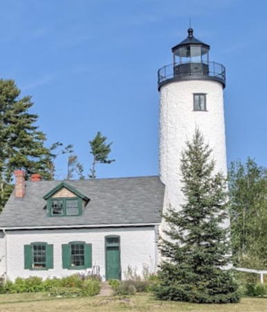
1857 Michigan Island Light, Apostle Islands, August 2021
Google Maps photo by Matthew Collins

Douglas County (Superior Harbor) Lighthouse
* Superior Entry South Breakwater (Wisconsin Point)
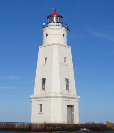
1913. Active; focal plane 70 ft (21 m); green flash every 5 s. 56 ft (17 m) round cylindrical concrete tower with lantern and gallery, attached to an unusual 2-story oval-shaped concrete keeper's quarters; DCB-24 aerobeacon (1970). Lighthouse painted white with bright red roofs; lantern and gallery rail are black. Fog horn (blast every 30 s) when needed. Two 2-story wood keeper's houses onshore. A photo is at the top of this page, Brenda Johnson has the 2021 photo seen at right, Bash has a photo, a 2014 photo is available, Joshua Peterson has a street view from the North Breakwater (in Minnesota), Marinas.com has aerial photos, and Google has a satellite view and a very distant street view. Google also has a street view and a satellite view of the two keeper's houses. The Superior Entry is the natural outlet for Superior Bay, the lagoon that forms the harbors of Superior, Wisconsin, and Duluth, Minnesota. A small wood lighthouse was built on the north pier of the Entry (in Minnesota) in 1879 and relocated to the south pier in 1892. The present lighthouse was built at the end of new breakwater piers constructed in 1912. The Coast Guard put a new roof on the lighthouse in 2007 and repaired the eaves in 2009. In 2013 the lighthouse became available for transfer under NHLPA. No suitable organizations came forward and in June 2016 the General Services Administration issued a second notice of availability. In July 2019 the lighthouse was put on sale at auction and in September it sold for $159,000 to Steven Broudy, a tech industry executive from San Francisco. He planned to renovate the interior as a vacation home or rent it through Airbnb but he failed to carry out any of these plans. Apparently he returned the property to the government and in June 2024 the General Services Administration was reoffering it under NHLPA. Located at the end of the south breakwater of Superior, at the end of Wisconsin Point Road. There are good views from an adjoining natural area. Accessible (with difficulty) by walking the breakwater. Site open, tower closed. Owner/site manager: private. ARLHS USA-829; USCG 7-15595.

Wisconsin Point Light, Superior, June 2021
Google Maps photo by Brenda Johnson

Bayfield County: Western Apostle Islands Lighthouses
The Apostle Islands are an archipelago of 22 islands in Lake Superior off the end of the Bayfield Peninsula. The largest island, Madeline Island, is the only one that is inhabited. The other islands are all included in the Apostle Islands National Lakeshore.

**
Sand Island
1881. Reactivated (inactive 1933-1985); focal plane 60 ft (18 m); white flash every 6 s. 40 ft (12 m) octagonal cylindrical sandstone tower with lantern and gallery attached to a 1-1/2 story Norman gothic sandstone keeper's house; DCB-24 aerobeacon (1980). Lantern painted black. Sibling of Chambers Island Light (see Northeastern Wisconsin): lower half of the tower is square and upper half octagonal. Brick oil house. David Martin's photo is at right, the park service also has a page for the lighthouse, Bill Britten has a photo, Wikimedia has Steve Mercer's closeup, Marinas.com has aerial photos, and Google has a closeup street view and a good satellite view. A handsome lighthouse, sometimes called the "Jewel of the Apostles."After it was automated in 1921 the building was leased as a vacation residence until 1975. Today it houses volunteer caretakers during the summer. The park service returned the light to the lighthouse in 1985, removing the 50 ft (15 m) skeletal tower that had carried it since 1933. This is one of five Apostle Islands lighthouses closed for repairs during summer 2013. A new roof was installed and gutters were repaired; interior restoration awaits further funding. Located on the northern tip of the island. Accessible only by boat; accessible in season by daily excursion boat and a 2-mile hike. Site open and the caretakers conduct tours during the afternoons in the summer. Owner: U.S. National Park Service. Site manager: Apostle Islands National Lakeshore. ARLHS USA-722; USCG 7-15580.

Sand Island Light, Apostle Islands, August 2019
Flickr Creative Commons photo by David Martin
*** Raspberry Island (2)
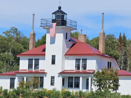
1906 (station established 1863). Inactive since 1957. 35 ft (10.5 m) square cylindrical wood tower with lantern and gallery, rising from a 2-story clapboard duplex keeper's house. The original 5th order Fresnel lens is on display at the Madeline Island Museum. Lighthouse painted white, lantern and gallery black; roof is red. 1-1/2 story brick fog signal building (1903) with red metal roof; barn, oil house, and other buildings. The solar-powered active light (focal plane 58 ft; white flash every 2.5 s) is mounted on a post in front of the fog signal building. A park service photo is at right, the park service also has a page for the lighthouse, Alex Gleeson has a 2021 photo, Bill Britten has good photos of the light station, Marinas.com has aerial photos taken during the 2006 restoration, and Google has a street view and a satellite view. The present lighthouse is an expansion and reconstruction of the 1863 light, incorporating portions of the older building. Endangered by shoreline erosion, the light station was placed on the Lighthouse Digest Doomsday List in April 2000. In October Congress appropriated $2 million for erosion control at Outer Island and Raspberry Island Lights. By summer 2003 that work had been completed at Raspberry Island. The Park Service carried out a $1.3 million restoration of the lighthouse itself during 2005-06 and the station reopened in 2007. The boathouse was restored in 2014. Located on the southwestern point of Raspberry Island about 3 miles (5 km) northeast of Point Detour on the mainland. This is the most accessible of the Apostle Islands lighthouses; a dock is available and excursion boats bring tourists to the light station daily in season. Site open, light station and tower open daily during the summer season. Owner: U.S. National Park Service. Site manager: Apostle Islands National Lakeshore. . ARLHS USA-688. Active light: USCG 7-15555.

Raspberry Island Light, Apostle Islands, August 2016
Google Maps street view by Ranger Scott

Ashland County: Eastern Apostle Islands Lighthouses
Devils Island (2)
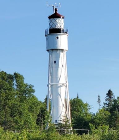
1901 (station established 1891). Active; focal plane 100 ft (31 m); red flash every 10 s. 71 ft (21.5 m) round cylindrical cast iron tower with square pyramidal steel bracing, lantern and gallery. The original 3rd order Fresnel lens was removed by the Coast Guard in 1989 and then returned to the tower by the park service in 1992, but it is not in use; the active light is a solar-powered 190 mm lens mounted on the gallery. Tower painted white, lantern black. Two 2-story Queen Anne brick and wood keeper's houses (1891 and 1896), two brick oil houses, and other buildings. One of the keeper's houses includes an apartment for a resident caretaker during the summer season. Original wood fog signal building. The tower also carries an array of weather instruments as a NOAA National Data Buoy Center C-MAN station. Pete Markham's photo is at right, the park service also has a page for the lighthouse, Luiz Felipe de Castro has a good photo, Koen De Vuyst has a 2020 photo, Marinas.com has aerial photos, Lighthouse Digest has other historic photos in a September 2003 article, and Google has a street view and a good satellite view. Marking the northernmost point of the Apostle Islands, this lighthouse replaced an 1891 wooden tower and is a sibling of the Sturgeon Bay Ship Canal Light (see the Northeastern Wisconsin page). The steel bracing was added in 1914 because high winds caused the tower to sway alarmingly. The Coast Guard has a 1913(?) historic photo of the lighthouse without the bracing, and Huelse has a historic postcard view also showing the original appearance of the station. This is one of five Apostle Islands lighthouses closed for repairs during summer 2014; the keeper's house was restored inside and out and new concrete footings were poured for the light tower; the exterior and foundation of the fog signal building were also restored. The Devils Island and Outer Island (next entry) lights guide vessels around the northern end of the archipelago. Located on the northern tip of Devils Island, about 10 miles (16 km) northeast of Point Detour on the mainland. Accessible only by boat; tour boats do not stop at this island but a dock is available and water taxi service is available in season. Site open, and the caretakers conduct tours in the summer. Owner: U.S. National Park Service. Site manager: Apostle Islands National Lakeshore. ARLHS USA-228; USCG 7-15565.

Devils Island Light, Apostle Islands, September 2012
Flickr Creative Commons photo by Pete Markham
Outer Island
1874 (O.M. Poe). Active; focal plane 130 ft (40 m); white flash every 10 s. 90 ft (27.5 m) round brick tower with lantern and gallery, attached to a 2-1/2 story brick keeper's house. Tower painted white with black trim; lantern roof is also black. Frame fog signal building, original but modified; twin type F diaphone foghorns (1929) in place. A photo by Milan Bindas is at right, the park service also has a page for the lighthouse, Marinas.com has aerial photos, Huelse has a historic postcard view, and Google has a good satellite view. A complete and well preserved light station. Endangered by shoreline erosion, the light station was placed on the Lighthouse Digest Doomsday List in April 2000. In October Congress appropriated $2 million to save both the Outer Island and Raspberry Island Lights. However, the Park Service needed nearly all the money for Raspberry Island; more than $2 million more was needed for Outer Island. The erosion contriol project was finally carried out in 2004-05. This is one of five Apostle Islands lighthouses closed for repairs during summer 2014; the tower was repaired and painted and the lantern glass replaced. The fog signal building received roof and foundation repairs. Located at the northern end of the island. Due to its remote location this is the most difficult of the Apostle Islands lighthouses to visit. The park service cautions, "Only the most experienced private boaters and sea kayakers should consider attempting a trip to this lighthouse, due to the great distance and exposed location. Even when lake conditions permit approach, the exposed location of the dock often makes landing impossible." Site open, tower occasionally open to tours in season. Owner: U.S. National Park Service. Site manager: Apostle Islands National Lakeshore. . ARLHS USA-572; USCG 7-15255.

Outer Island Light, Apostle Islands, August 2018
Google Maps photo by Milan Bindas
Gull Island
1928. Active; focal plane 56 ft (17 m); white flash every 10 s. 50 ft (15 m) square pyramidal steel skeletal tower with gallery, painted black; 250 mm lens. No keeper's house; keepers at Michigan Island were responsible for maintenance until 1943. The shadow of the tower is conspicuous in Google's satellite view. This light was maintained by the Michigan Island Light keepers. Located on a small island at the end of a sandbar about 1 mile (1.6 km) off the northeast tip of Michigan Island. Accessible only by boat. Site open, tower closed. Owner: U.S. Coast Guard. Site manager: Apostle Islands National Lakeshore. ARLHS USA-1065; USCG 7-15260.
Michigan Island (1)
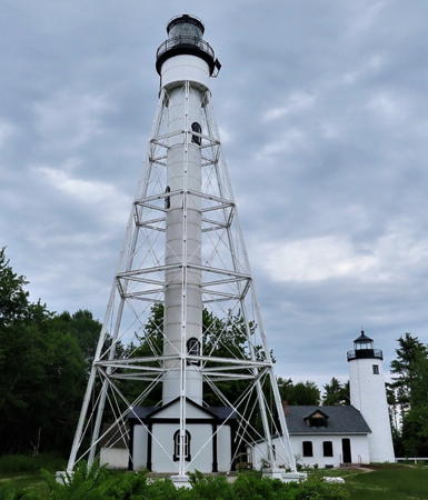
1857. Inactive 1858-1869 and since 1929. 64 ft (19.5 m) round brick tower with lantern and gallery, attached to a 1-1/2 story brick keeper's house. The (3-1/2) order Fresnel lens (1869) is on display at the national lakeshore visitor center in Bayfield. Tower and keeper's house painted white; lantern is black. Matthew Collins has the 2021 photo seen at the top of this page, Lighthouse Digest has Jim Merkel's article on the history of the light station, and Google has a street view and a satellite view. This is one of five Apostle Islands lighthouses closed for repairs during summer 2014; a thorough restoration including painting, plastering, a new roof, and new exhibits. Located on the southwestern end of Michigan Island. The park service cautions, "Only the most experienced private boaters and sea kayakers should consider attempting a trip to this lighthouse, due to the great distance and exposed location. Even when lake conditions permit approach, the exposed location of the dock often makes landing impossible." Site open, tower normally open to guided tours in season. Owner: U.S. National Park Service. Site manager: Apostle Islands National Lakeshore. ARLHS USA-947.
Michigan Island (2)
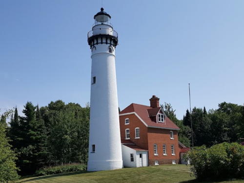
1880; relocated to this site in 1929. Active; focal plane 170 ft (52 m); white flash every 6 s. 102 ft (31 m) hexagonal pyramidal cast iron skeletal tower with central cylinder, lantern and gallery; solar-powered LED beacon. 2-story brick keeper's house (1928), 1-1/2 story assistant keeper's house, barn, and other buildings. Tower painted white, lantern black. Austin Gruenweller's photo is at right, the national lakeshore's page has additional photos and information, Marinas.com has aerial photos, and Google has a street view and a satellite view. A sibling of the Liston Range Rear Light in Delaware, this tower was relocated from Schooner Ledge on the Delaware River in Pennsylvania (the Coast Guard has a photo of the tower at its original location). Located adjacent to the older tower. Accessible only by boat (dock available; water taxi service available in season). Site open, tower closed. Owner: U.S. National Park Service. Site manager: Apostle Islands National Lakeshore. . ARLHS USA-494; USCG 7-15275.


1880 Michigan Island Light, Apostle Islands National Park, July 2007
Flickr Creative Commons photo by Austin Gruenweller


Ashland County: Long Island and Ashland Lighthouses
Ashland Breakwater
1915. Active; focal plane 60 ft (18 m); white flash every 6 s. 58 ft (17 m) square pyramidal reinforced concrete tower topped by cylindrical watch room and lantern; solar-powered 250 mm lens. Lighthouse is white; lantern dome painted red. The original 2-story wood keeper's house is onshore (there were also living quarters in the tower). Greg Minor's photo is at right, Wikimedia has Lana Froemming's summer 2019 photo, a winter 2019 photo is also available, Marinas.com has aerial photos, and Bing has a satellite view. Google has a satellite view of the keeper's house on Lakeshore Drive at 32nd Street in Ashland. In December 2014 Congress approved the transfer of the lighthouse to the national lakeshore. This transfer was celebrated along with the 100th anniversary of the lighthouse in July 2015. The lighthouse is built at the end of 1.5 mi (2.5 km) long detached breakwater that protects the harbor of Ashland. Accessible only by boat; the breakwater is not walkable. There are views from Bayview Park, off US 2 east of downtown. Site and tower closed. Owner/site manager: U.S. National Park Service. Site manager: Apostle Islands National Lakeshore. . ARLHS USA-019; USCG 7-15310.
Chequamegon Point (1)
1896. Inactive since 1987. 42 ft (13 m) square pyramidal cast iron skeletal tower with lantern, gallery, and an enclosed workroom below the lantern. Lighthouse painted white, lantern roof red. Keeper's house burned. Lighthouse Digest has Jim Merkel's article on the history of the light station, the national lakeshore has a page on all the Long Island lighthouses, Marinas.com has aerial photos, the Coast Guard has a closeup historic photo, and Google has a satellite view. Located at the western end of Long Island, about 2/3 mile (1 km) west of LaPointe Light. A Coast Guard helicopter moved the tower back 150 ft (45 m) from the eroding shoreline in 1987. Accessible only by boat; water taxi service available in season. Site open, tower closed. Owner: U.S. National Park Service. Site manager: Apostle Islands National Lakeshore.
[Chequamegon Point (2)]
1987. Active; focal plane 33 ft (10 m); green flash every 4 s. 35 ft (11 m) round cylindrical steel tower, painted white, with 300 mm lens at the top. This "D9" tower is similar to many others on the Great Lakes. Built next to the 1895 tower. Accessible only by boat; water taxi service available in season. Site open, tower closed. Owner: U.S. Coast Guard. Site manager: Apostle Islands National Lakeshore. ARLHS USA-164; USCG 7-15295.
Ashland Breakwater Light
Ashland Breakwater Light, March 2008
Flickr photo copyright Greg Minor; permission requested
[LaPointe (1)]
1858. Inactive since 1896 and abandoned since 1938. The original lighthouse was a square wood tower rising from one end of a 1-1/2 story keeper's house. The park service has a historic photo. When a new lighthouse was built in 1896 the light tower was removed and the building was expanded to 2-1/2 stories for use as a duplex keeper's house. The building is now in ruins. Located on Long Island about 1/4 mile (400 m) east of Chequamegon Point and 3/4 mile (1.2 km) west of the 1896 LaPointe (2) Light. Site open. Owner: U.S. National Park Service. Site manager: Apostle Islands National Lakeshore.
LaPointe (2)
1896. Active; focal plane 70 ft (21 m); green light 3 s on, 3 s off. 65 ft (19.5 m) square pyramidal steel tower with lantern, double gallery, and central cylinder. A sibling of the Coney Island Light in New York. 2-story wood keeper's house (1938), brick oil house, iron oil house. Also at this site is the foundation of an 1891 fog signal building. Norm Walkers' photo is at right, he also has a drone view, a 2021 view from the lake is available, Marinas.com has aerial photos, and Google has a satellite view. Lighthouse Digest also has an article on the history of the light station. This is one of five Apostle Islands lighthouses closed for repairs during summer 2014; the keeper's house received a new roof and new footings for the light tower were installed. Located on Long Island, in the mouth of Chequamegon Bay northeast of Washburn. Accessible only by boat; water taxi service available in season. Site open, tower closed. Owner: U.S. National Park Service. Site manager: Apostle Islands National Lakeshore. . ARLHS USA-423; USCG 7-15280.

LaPointe Light, June 2020
Google Maps photo by Norm Walker
 

Information available on lost lighthouses:

Adjoining pages: North: Minnesota | East: Northern Upper Michigan

Return to the Lighthouse Directory index

Posted September 2002. Checked and revised October 11, 2023. Lighthouses: 12. Site copyright 2023 Russ Rowlett and the University of North Carolina at Chapel Hill.