Lighthouses of the United States: Southeastern Wisconsin

The United States of America is a federal union of 50 states and a capital district. Located in the western Great Lakes region, the U.S. state of Wisconsin has two coastlines. One coastline faces north on Lake Superior and includes the Apostle Islands stretching out into the lake. The other coastline faces east on Lake Michigan. This page includes lighthouses of the Lake Michigan coastline south of the Door Peninsula, as well the lighthouses of Lakes Winnebago and Mendota. Lighthouses of Green Bay and the Door Peninsula are described on the Northeastern Wisconsin page, and lighthouses of the Lake Superior coastline are described on the Northern Wisconsin page.

When Wisconsin was organized as a territory in 1936 it included all of the modern states of Minnesota and Iowa and the eastern half of North and South Dakota. In 1838 the area west of the Mississippi River was split off as Iowa Territory. Wisconsin, with its present boundaries, was admitted to the Union as the 30th state in 1848.

Aids to navigation in eastern Wisconsin are maintained by the U.S. Coast Guard Sector Lake Michigan based in Milwaukee with an Aids to Navigation Team based at Two Rivers, but ownership (and sometimes operation) of historic lighthouses has been transferred to local authorities and preservation organizations in many cases.

ARLHS numbers are from the ARLHS World List of Lights. USCG numbers are from volume 7 of the U.S. Coast Guard List of Lights.

General Sources
Seeing the Lights - Wisconsin
This outstanding site, written by the late Terry Pepper, has photos and historical accounts for nearly all of the lighthouses.
Wisconsin Lighthouses
Part of Kraig Anderson's outstanding LighthouseFriends.com site, including photos and historical accounts for nearly all the lighthouses.
Lake Michigan Lighthouses to Visit in Wisconsin
Information on eight lighthouses open to the public, by Chelsey Lewis for the Milwaukee Journal Sentinel.
The Lighthouses of Lake Winnebago
An account by Karen Lee Ensley for familyRVing magazine.
Lighthouses in Wisconsin, United States
Excellent aerial photos posted by Marinas.com.
Lake Michigan Lighthouses
Excellent photos by C.W. Bash.
Lighthouses in Wisconsin
Photos by various photographers available from Wikimedia.
Leuchttürme USA auf historischen Postkarten
Historic postcard images posted by Klaus Huelse.
U.S. Coast Guard Navigation Center: Light Lists
The USCG Light List can be downloaded in pdf format.
NOAA Nautical Charts
Official nautical charts for the coast can be viewed online.
Navionics Charts
Navigation chart for Lake Michigan.


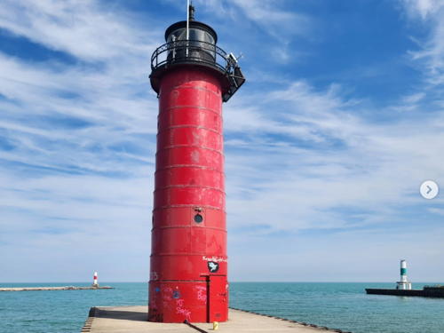
Milwaukee Pierhead Light, Milwaukee, June 2008
Flickr Creative Commons photo by Dori


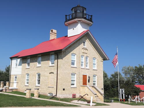
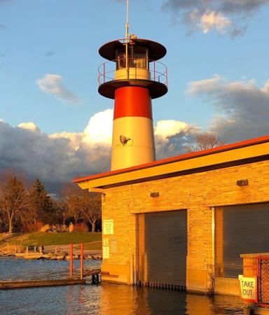
Port Washington Light, Port Washington, September 2022
Google Maps photo by Andy Kralick
Lake Michigan Lighthouses

Manitowoc County Lighthouses
* Rawley Point (Twin Rivers Point) (1)
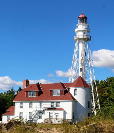
1874. Inactive since 1894. Round brick tower, now capped by a conical roof and incorporated into the keeper's house for the 1894 lighthouse. A photo is at right.
* Rawley Point (Twin Rivers Point) (2)
1894. Active; focal plane 113 ft (33.5 m); white flash every 15 s. 111 ft (33 m) octagonal pyramidal steel tower with central cylinder, lantern and gallery; twin DCB-36 aerobeacons. Lighthouse painted white, lantern roof red. The 2-1/2 story brick keeper's house, attached to the truncated 1874 lighthouse, is used as a vacation cottage for Coast Guard personnel. 1-1/2 story wood fog signal building. A photo is at right, Pepper has an excellent page for the lighthouse, Bear Huelman has an excellent photo, Tim Gasser has a 2021 photo, Debbie Weichman has a 2017 photo, William Ehrendreich has a 2016 street view, Lighthouse Digest has Timothy Harrison's article on the history of the lighthouse, and Google has a satellite view. The tower incorporates the skeletal section of the 1859 Chicago North Pier lighthouse. Only two other lighthouses of this robust design survive (Cape Charles, Virginia, and Hillsboro Inlet, Florida). Accessible by road; parking provided. Located in Point Beach State Forest (Rawley Point Lighthouse) off County Road O about 5 mi (8 km) northeast of Two Rivers. Site and tower closed but the lighthouse can be seen from the beach. Owner/site manager: U.S. Coast Guard. . ARLHS USA-689; USCG 7-20935.
** Two Rivers (1)
1886 (rebuilt in 1928). Inactive since 1969 (donors can have the lighthouse lit on specific dates to honor loved ones). 36 ft (11 m) square pyramidal wood tower, the upper portion enclosed, with lantern and gallery. No keeper's house; the light was tended by the Rawley Point keepers. Lighthouse painted red with a white lantern. Pepper has a page for the lighthouse, Michael Matusinec has a closeup photo, Andy Kralick has a 2022 closeup photo, and Google has a street view and a satellite view. This is the only example of a wood pierhead light surviving on the U.S. upper Great Lakes. Formerly located at the end of the harbor breakwater, this lighthouse was relocated in 1975 by the Two Rivers Historical Society as part of the Rogers Street Fishing Village. The wide lower gallery and staircase were added in 1988 to permit public access. In 2003 the exterior of the lighthouse was restored, and there were plans to restore the interior. The original 6th order Sautter &Co. Fresnel lens, broken during the relocation, was carefully restored and placed on display at the lighthouse in 2009. Located at 2413 Jackson Street, just south of WI 42 on the east bank of the East Twin River in Two Rivers, a town of about 11,000 residents. Site open (small admission fee to the Fishing Village), tower open to tours May through October. Owner/site manager: Rogers Street Fishing Village (1886 Lighthouse ). ARLHS USA-862.

Rawley Point Light, Two Rivers, September 2020
Instagram photo by PhotographybyBrianna
* [Two Rivers North Pierhead (2)]
1969. Active; focal plane 34 ft (10 m); red flash every 2.5 s. Approx. 30 ft (9 m) round cylindrical "D9" tower painted white with a red horizontal band. Bryan Silvernail has a photo, Brandy Holmes has a photo, Don Krause has a 2017 street view, and Google has a satellite view. Located at the end of the north pier at Two Rivers. Accessible by walking the pier; parking is available behind the Two Rivers Coast Guard Station. Site open, tower closed. USCG 7-20925.
** Manitowoc Breakwater (2)
1918 (station established 1895). Active; focal plane 52 ft (16 m); white light, 3 s on, 3 s off. 40 ft (12 m) round cylindrical steel tower with lantern and two galleries, mounted on a 2-story square steel keeper's quarters. The original 4th order Fresnel lens is on display at the Wisconsin Maritime Museum in Manitowoc. Lighthouse painted white, lantern black. Cast iron fog signal building (1895); fog horn (2 blasts every 30 s) on demand. Jeff Smucker has the good photo at right, Pepper has a page for the lighthouse, Andy Kralick has a 2022 photo, Eli Duke has a photo, and Google has a satellite view and a closeup street view. In 2009 the lighthouse became available for transfer under NHLPA. The Maritime Museum initially expressed interest in acquiring it but later decided against doing so. In 2010 the Coast Guard announced that due to repeated painting of graffiti on the building it might be necessary to close off public access. Late in 2010 the lighthouse was offered at auction and in January 2011 it was sold for $30,000 to Philip Carlucci of Melville, New York. In June 2014 another instance of vandalism caused city officials to close the pier temporarily. Carlucci spent over $300,000 restoring and securing the lighthouse, a project completed in the summer of 2018. City officials cooperated with the project and Carlucci arranged for the Manitowoc Sunrise Rotary Club to serve as "keeper," keeping an eye on the lighthouse and offering tours on special occasions. Manitowoc is a city of about 35,000 residents. Located at the end of the breakwater on the north side of the harbor, at the end of Maritime Drive. Parking available at the marina nearby. Accessible in good weather by walking the breakwater, but it's not a short walk; parking is available. There's also a fine view from the ferry SS Badger, which crosses Lake Michigan between Manitowoc and Ludington, Michigan, mid May through mid October; Duke's photo and Smucker's photo were both taken from the ferry. Site open, and tours of the tower can be arranged. Owner/site manager: private. . ARLHS USA-471; USCG 7-20860.

Manitowoc Breakwater Light, Manitowoc, July 2018
Google Maps photo
by Jeff Smucker

Sheboygan County Lighthouses
* [Sheboygan North Point (2)]
1860 (station established 1839). Inactive since 1904. Originally a schoolhouse-style lighthouse with a square light tower at the front of the roof of the keeper's house. In 1916 the house was relocated as a private residence to 120 Lighthouse Court, between North First and Second Streets, in Sheboygan. Anderson has a photo of the house at its present location and Google has a street view and a satellite view. Site closed but the house can be viewed from the street. Owner/site manager: private. ARLHS USA-1242.
* Sheboygan Breakwater (2)
1905 (relocated to present site in 1915) (station established 1900). Active; focal plane 55 ft (17 m); continuous red light. 50 ft (15 m) round steel tower, painted bright red, incorporating a fog signal and surmounted by a navigation beacon; lantern removed. Fog horn (blast every 30 s) on demand. The tower also carries an array of weather instruments as a NOAA National Data Buoy Center C-MAN station. A photo is at right, Pepper has a page for the lighthouse, Michael Matusinec has a fine photo, Yadhira Tenorio has a 2020 photo, Jamil Alossaimi has a 2023 photo, Ben Caruso has a 2015 street view, Dan Klonowski has a closer street view, and Google has a satellite view. The lighthouse was originally on the North Pier as the third light at that site (station established 1873); it was relocated when the breakwater was completed in 1915. Sibling of Kenosha Pierhead Light. Sheboygan is a city of about 50,000 residents located about 80 km (50 mi) north of Milwaukee. Located at the end of the breakwater on the north side of the harbor. Accessible in good weather by walking the breakwater from Deland Park in downtown Sheboygan (no handrails). Site open, tower closed. Owner/site manager: U.S. Coast Guard. . ARLHS USA-752; USCG 7-20820.

Ozaukee County Lighthouses
** Port Washington Main (2)
1860 (station established 1849). Inactive since 1903 (the building continued in use as a Coast Guard station until 1992). Square cylindrical wood light tower with lantern and gallery mounted on a 2-1/2 story brick keeper's house. The light tower was removed in 1934 and rebuilt in 2002. The lighthouse is unpainted but with a bright red roof; the light tower is white with a black lantern. Andy Kralick's 2022 photo is at the top of the page, Pepper has a page for the lighthouse, C.M. Hanchey has a good photo, Antonio Espindola Parra has a 2021 photo, and Google has a street view and a satellite view. Restoration of the building began in 2000 when the government of Luxembourg offered to build a replacement light tower and lantern to honor Luxembourg citizens who emigrated to Port Washington and American servicemen who liberated Luxembourg in World War II. Lighthouse Digest reported on these efforts in March 2001. The new tower was dedicated on 16 June 2002. The 150th anniversary of the lighthouse was celebrated in 2010. The building is a maritime and lighthouse museum; a resident keeper lives upstairs. Port Washington is a county seat of about 12,000 residents located about 43 km (27 mi) north of Milwaukee. Located at Johnson and Power Streets in downtown Port Washington. Site open, museum open Friday, Saturday and Sunday afternoons from Memorial Day (late May) through mid October (admission fee; group tours can be arranged during the winter). Owner: City of Port Washington. Site manager: Port Washington Historical Society (Port Washington Lighthouse). ARLHS USA-652.

Sheboygan Breakwater Light, Sheboygan, July 2007
Flickr Creative Commons photo
by ~Ealasaid~
Port Washington Breakwater (2)
1935 (station established 1889). Active; focal plane 78 ft (24 m); red flash every 6 s. 58 ft (18 m) round cylindrical steel tower with gallery, mounted on a raised concrete platform at the end of the breakwater; lantern removed. Entire lighthouse painted white. Fog horn (2 blasts every 30 s). A photo is at right, Pepper has a page for the lighthouse, Brian Holzhausen has a 2021 photo, Wesley Wahlberg has a 2015 street view, and Google has a satellite view. Built as one of only two maritime projects of the Works Project Administration (WPA), the lighthouse replaced an 1889 wooden tower. Access to the lighthouse was closed for years due to unsafe conditions on the breakwater, but in March 2014 the Corps of Engineers announced a $950,000 project to repair the pier and restore access. The lighthouse become available through NHLPA in May 2015. The city submitted an application late in the year. The application was approved and the city received the deed to the lighthouse in April 2018. In December 2018 the lighthouse was added to the National Register of Historic Places. In July 2021 the city asked the state to allocate $2.5 million in federal funds to restore the lighthouse. In May 2022 the state granted $40,000 for engineering studies needed before a restoration. Located at the end of the breakwater on the north side of the harbor. Accessible in good weather by walking the pier (1/2 mi long, no railings). Parking is available at the end of Jackson Street. Site and tower closed. Owner/site manager: City of Port Washington. . ARLHS USA-653; USCG 7-20770.
Kevich
1981. Active (privately maintained); focal plane 163 ft (49.5 m); white light, 4 s on, 4 s off. 50 ft (15 m) round stucco-clad tower with lantern and gallery, adjoining residence. Lighthouse painted white, lantern and gallery black. Kenya Allmond has a 2019 closeup photo, another closeup photo is available and Google has a street view and a satellite view. Privately built by the Kevich family, this lighthouse has the highest focal plane of any active U.S. Great Lakes lighthouse except the Boyer Bluff Light (see the Northeastern Wisconsin page). The Coast Guard accepted the light as a private aid to navigation in 1990. Since 1996 the lighthouse has been owned by Dave and Mary Bennett. Located atop a high bluff at 1271 Lakeshore Road, a short distance north of Ulao Road, in the town of Grafton, about 4 miles (6.5 km) south of Port Washington. Site and tower closed. Owner/site manager: private. ARLHS USA-1066; USCG 7-20765.

Port Washington Breakwater Light, Port Washington, July 2006
Flickr Creative Commons photo by Radon360

Milwaukee County Lighthouses
The largest city of Wisconsin, Milwaukee has a population of about 575,000 within the city limits and a metropolitan area population of about 1.5 million. Port Milwaukee is the state's largest port.
** North Point (Milwaukee) (2)
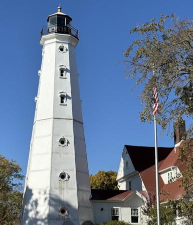
1888 (raised onto steel foundation in 1913; station established 1855). Inactive since 1994. 74 ft (23 m) octagonal cast iron tower with lantern and gallery, mounted on steel foundation. Lighthouse painted white, lantern black. Original 2-1/2 story wood keeper's house (1855) now in use as a maritime museum. John Skodak's photo is at right, Terry Pepper has a page with many photos and historical information, Anderson has a fine page with photos, a 2017 closeup is available, Jeffrey Mehlhorn has a 2015 street view, Huelse has a historic postcard view, Samantha Garlejo has a 2017 street view, and Google has a good satellite view. The North Point Lighthouse Friends organization was formed to work for restoration of the site. The group was awarded a $984,000 grant in 2002. Ownership was transferred to Milwaukee County in 2003 and the county immediately leased the light station to the Friends. Restoration began in 2004 and was completed in November 2007, allowing the lighthouse to be opened to visitors. A November 2007 photo shows the completed project. The 4th order Fresnel lens (1868), removed from the tower in 1994, was returned in 2009 and is on display. Located on Wahl Street at Terrace Street, just off WI 32, in Milwaukee's Lake Park. Site open, museum and tower open Saturday and Sunday afternoons year round (group tours can be arranged). Owner: Milwaukee County Parks; site manager: North Point Lighthouse Friends . ARLHS USA-556.
Milwaukee Breakwater
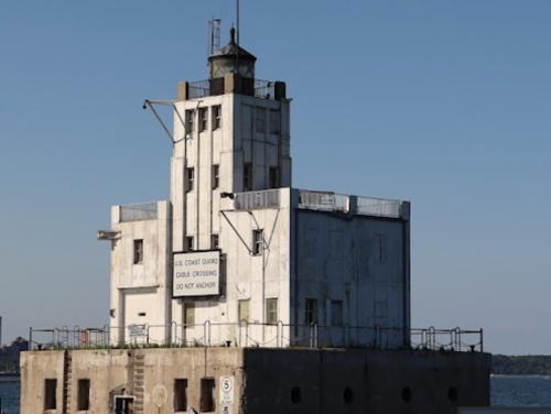
1926. Active; focal plane 61 ft (18.5 m); red flash every 10 s. 56 ft (17 m) square cylindrical steel tower with lantern and gallery, mounted on a 2-story steel art deco keeper's quarters. Lighthouse painted white. The original 4th order Fresnel lens (1906, transferred from the pierhead light) is on display at the Wisconsin Maritime Museum in Manitowoc. Lighthouse painted white, lantern black. The lighthouse is floodlighted throughout the night. Fog horn (2 blasts every 20 s) when needed. Pepper has a page for the lighthouse, Scott Kutcka has a photo, R.J. Rauen has a 2021 drone view, Google has a satellite view and a very distant street view of the breakwater and pierhead lighthouses, and Lighthouse Digest has a historical account of life at the light station. Endangered. In 2011 the lighthouse became available for transfer under NHLPA and in 2013 it was transferred to Optima Enrichment, a local foundation. The foundation planned to restore the lighthouse and open it to the public; it estimated that $2.5 million would be required for the restoration. A support group, the Milwaukee Breakwater Lighthouse Friends , was formed. By early 2016, according to local press accounts, there was little progress to show for these efforts, and as of 2023 there appears to be no activity at the lighthouse. Located at the end of the breakwater on the north side of the harbor. Accessible only by boat (the breakwater is not connected to shore). Site and tower closed. Owner/site manager: Optima Enrichment. ARLHS USA-497; USCG 7-20635.
North Point Light
North Point Light, Milwaukee, March 2009
Flickr Creative Commons photo by John Skodak
* Milwaukee Pierhead (2)
1906 (station established 1872). Active; focal plane 45 ft (13.5 m); red flash every 4 s. 42 ft (12.5 m) round steel tower with lantern and gallery. Lighthouse painted red, lantern black. The original 4th order Fresnel lens was transferred to Milwaukee Breakwater Light in 1926 and is now on display at the Wisconsin Maritime Museum in Manitowoc. The 5th order Fresnel lens installed in 1926 was removed in 2005; its whereabouts is unknown. Tower painted red, lantern black. A photo is at the top of this page, Pepper has a good page with several photos, Fred Schulze has a 2021 photo, Huelse has a historic postcard view, Bob Solem has a street view, and Google has a good satellite view. Sibling of the Kenosha Pierhead Light (see below). An August 2008 photo shows that the tower had been painted recently. In May 2014 the lighthouse became available for transfer under NHLPA. No suitable organizations came forward. Ordinarily the lighthouse would then be sold at auction, but the Corps of Engineers decided it did not wish to lease or sell space on the pier to a private party. In June 2016 the General Services Administration issued a second notice of availability, but there doesn't seem to have been any further action. Located at the end of the short pier at the foot of Erie Street in downtown Milwaukee, where parking is available. Accessible by walking the pier. Site open, tower closed. Owner/site manager: U.S. Coast Guard. . ARLHS USA-498; USCG 7-20670.

Racine County Lighthouses
Racine, the county seat, is a city of about 75,000 residents.
** Wind Point
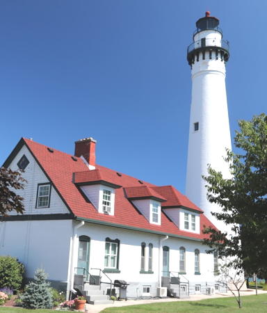
1880 (O.M. Poe). Active; focal plane 111 ft (34 m); white flash every 20 s. 108 ft (33 m) round brick tower with lantern and gallery, VRB-25 lens. Lighthouse painted white, lantern and gallery black. The 1-1/2 story brick keeper's house is occupied by resident caretakers, but part of the building is used as a town meeting hall. The original 3rd order Fresnel lens is on display. Brick fog signal building (1900) including the twin diaphone horns. Jim Bauer's photo is at right, Anderson has an excellent page for the lighthouse, Pepper also has a fine page, Andy Kralick has a 2022 photo, Dawn Perry has a good photo, Huelse has a historic postcard view, and Google has a street view and a satellite view. A fund drive was launched in 1999 by Friends of Wind Point Lighthouse to provide for renovation of the tower. A project in 2000 restored the exterior of the lantern and provided landscaping improvements. In May 2007 the Jeld-Wen Company announced that the lighthouse would receive new windows and doors as the co-winner of a national competition. Also in 2007 the DCB-24R aerobeacon failed and was replaced by a VRB-25 lens; this led to complaints that the light is too dim. In November 2015 Racine County agreed to budget some additional support for the lighthouse, which had been entirely a village responsibility. Chimney and roof repairs for the keeper's house were planned for 2016. In March 2016 the Village took full control of the light station, ending its agreement with the Friends group. In 2017 the Friends group reorganized as the Racine Lighthouse and Maritime Preservation Society (RLAMPS), taking as its mission education efforts for all the Racine area lighthouses. Located at the end of Lighthouse Road in Wind Point, about 3 miles (5 km) north of Racine. Site open, tower usually closed but open for tours on the first Sunday of each month June through October; reservations are recommended. Owner/site manager: Village of Wind Point (Wind Point Lighthouse ). ARLHS USA-894; USCG 7-20605.
Racine Harbor (Root River) (2)
1865 (station established 1839). Inactive since 1901. Square cylindrical wood tower on a 2-1/2 story wood keeper's house; the lantern has been replaced by an ordinary shingled roof. Pepper has a page for the lighthouse, the Wisconsin Historical Society has a page with photos, and Google has a satellite view. The building was renovated for use as the Racine Harbor Lifesaving Station in 1903 and it continued in use for many years as part of the Racine Coast Guard Station. After the station was closed the building was sold. According to the Historical Society it is occupied by the Racine County Sheriff's Water Safety Patrol. Located at 2 Reichert Court at the harbor entrance in Racine. Site open, tower. Owner/site manager: Racine County. ARLHS USA-683.

Wind Point Light, Wind Point, September 2017
Flickr Creative Commons photo by Jim Bauer
Racine North Breakwater (2)
1901 (relocated here in 1924; station established 1900). Inactive since 1987; charted as a landmark. 46 ft (14 m) square steel skeletal tower with lantern and gallery; lantern room and upper portion of tower enclosed. Entire lighthouse painted red. A closeup photo is available, Pepper has a page with good photos, Michael Alloian has a 2023 photo, Richard Cable has a 2017 photo, Josh Dixon has a street view, and Google has a satellite view. This tower was originally built as the Racine North Pierhead Light; it was moved to the breakwater in 1924. Floodlit at night, the lighthouse serves as an ornament of the city's waterfront park. Originally mounted on a crib, now located on a rip rap breakwater on the north side of the harbor entrance, adjacent to the Coast Guard station. Site and tower closed. Owner/site manager: City of Racine. ARLHS USA-682.
* Racine West Harbor Entrance
Date unknown. Active (privately maintained); focal plane 52 ft (16 m); quick-flashing green light. Approx. 46 ft (14 m) square skeletal tower with gallery, painted white and mounted on a square concrete base. Fog horn (two 2 s blasts every 18 s). There is a small equipment shelter inside the base of the tower. A 2022 photo is available, Donnie Brown has a 2018 photo, Josh Dixon has a street view, and Google has a satellite view. Site open, tower closed. USCG 7-20495.
Racine Reef (4)
2008 (station established 1899). Inactive since 2022 but probably maintained as a daybeacon. 50 ft (15 m) square skeletal tower painted white. Lighthouse painted white. Fog horn (blast every 15 s) operating continuously April through November. Pepper has a page for the lighthouse and Bing has a satellite view. This light is the current replacement for a beautifully ornate late Victorian lighthouse built in 1906 and demolished in 1961; Huelse has a postcard view of that lighthouse. The 1961 light was a red skeletal tower with an enclosed workroom. Located on a shoal about 1 mile (1.5 km) off Pershing Park in downtown Racine. In 2011 the Coast Guard rebuilt the foundation of the light; the tower was removed, refurbished, and returned. Accessible only by boat. Site and tower closed. Site manager: U.S. Coast Guard. ARLHS USA-684; USCG 7-20480.

Kenosha County Lighthouses
Locted in the southeastern corner of Wisconsin adjoining the Illinois state line, Kenosha is a city of about 100,000 residents.
*** Kenosha (Southport) (3)
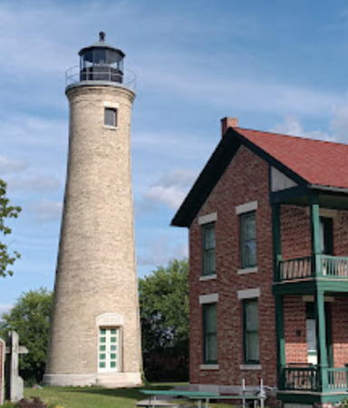
1866 (station established 1848). Inactive as an official light since 1906, when it was replaced by the pierhead light (below); a decorative light is displayed to recognize donations to the maintenance fund of the lighthouse. 300 mm lens. 52 ft (16 m) round brick tower with lantern and gallery, attached to 2-story brick keeper's house; 300 mm lens. The lantern is a replica (1994); the original lantern was removed in 1913. Lighthouse is unpainted; lantern painted black. The keeper's house remained in service to about 1940. Tom Gill's photo is at right, Terry Pepper's page has excellent information and photos, Anderson's page has good photos, Julie Heeren has a 2022 photo, a good 2016 photo is available, and Google has a street view and a satellite view. The first (1848) and second (1858) lighthouses had to be demolished because the bricks used were too soft to withstand the winter weather. After deactivation the light station continued as the keeper's house for the pierhead lighthouse until 1940; the lantern was replaced with a tower displaying storm warning signals. The light tower was scheduled for demolition in 1955 but at the request of local residents it was transferred instead to the City of Kenosha. In 1989 a Lighthouse Preservation Committee was formed to coordinate restoration efforts with the City of Kenosha and the Kenosha History Center. By 1994 funds were available to replace the lantern room and restoration of the tower has continued. The keeper's house was purchased from its private owners and restoration of that building began in 2005. Lighthouse Digest has an article on the restoration. The first floor of the house was opened as a museum in May 2010. The 150th anniversary of the lighthouse was celebrated in August 2016. Located on Simmons Island Road north of the harbor entrance in Kenosha. Site open, museum and tower open Thursday through Sunday afternoons early May through October. Owner: City of Kenosha. Site manager: Kenosha History Center ARLHS USA-912.

Southport Light, Kenosha, February 2008
Flickr Creative Commons photo by Tom Gill
* [Kenosha Breakwater (3)]
Date unknown (1960s) (station established 1906). Active; focal plane 6 m (20 ft); red flash every 4 s. 5 m (17 ft) round cylindrical "D9" tower, painted white with one red horizontal band. Luiz Felipe de Castro has a photo, Tom Birchard has a street view, and Google has a satellite view. The original lighthouse here was an octagonal tower with a pyramidal base, covered with corrugated iron. Pepper has a postcard view of this very unusual lighthouse and it can be seen also in Huelse's postcard view of the pierhead lighthouse. It was replaced by a skeletal tower in 1921 and then by the D9 tower in the 1960s. Located at the end of a detached breakwater about 200 m (650 ft) east of the pierhead lighthouse. Accessible only by boat. Site open, tower closed. Owner/site manager: USCG 7-20430.
* Kenosha North Pierhead (3)
1906 (station established 1856). Active; focal plane 50 ft (15 m); red light, 3 s on, 3 s off. 50 ft (15 m) round steel tower with lantern and gallery, mounted at the end of the pier; 250 mm lens. Tower painted bright red, lantern and gallery black. Originally attached to a steel fog signal building, which has been removed. Fog horn (blast every 30 s). Keepers lived at the Southport light (previous entry). Richard Riedling 's photo is at right, Pepper has a page for the lighthouse, Damian Panek has a 2021 photo, Huelse has a historic postcard view, Tom Birchard has a street view, and Google has a satellite view. This lighthouse is a sibling of the Muskegon South Pierhead Light in Michigan. The original lighthouse was destroyed by a storm in 1860; a second lighthouse was built in 1867. In late 2010 the General Services Administration offered the lighthouse for sale at auction but no acceptable bids were received. After a second auction the lighthouse was sold in July 2011 to John Burhani, a local artist. Burhani used the tower as his studio and opened the tower occasionally for the public to view his works. Unfortunately, Burhani died of cancer in 2015, only 49 years old. His widow Heather McGee now owns the lighthouse; in honor of her late husband she invited other local artists to paint a series of murals around the lower section of the tower in summer 2016. She also installed floodlights to light the tower at night and security cameras to deter vandalism. Beginning in 2017 a more ambitious Artist in Residence program boosted public interest and support with a series of exhibitions and concerts. By 2024 Ms. McGee herself was fighting cancer and her daughter Emily manages the lighthouse; it is in need of repainting and repairs. Located at the end of the pier on the north side of the harbor, at the south end of Simmons Island. Parking is available at the foot of the pier. Site open, tower generally closed but a variety of events are held at the lighthouse frequently during the summer. Owner: private. Site manager: Kenosha Lighthouse Studio . ARLHS USA-416; USCG 7-20415.

North Pierhead Light, Kenosha, March 2013
Flickr Creative Commons photo by Richard Riedling II

Fox River and Lake Winnebago Lighthouses

Lake Winnebago is about 30 mi (19 km) long and 10 mi (16 km) wide. The lake empties into Green Bay through the Fox River. In the late 1800s a series of 17 locks made the river navigable, but these locks fell into disuse for many years. In 2004 the state established the Fox River Navigational System Authority (better known as Fox Locks) to restore and operate the locks. As of 2016 this work was complete. One lock (Rapide Croche) remains closed to prevent the spread of invasive species between the lakes; a boat lift and cleaning station are installed instead. Aids to navigation on the river and on Lake Winnebago are regulated by the State of Wisconsin and inspected by the Coast Guard Auxiliary.

Outagamie County (Fox River) Lighthouse
* Appleton Yacht Club
2012. Active; focal plane about 36 ft (11 m); flashing white light. 35 ft (10.5 m) round tower with lantern attached to one end of a clubhouse building. Entire lighthouse is white. Construction of the lighthouse was part of a $500,000 project to expand club facilities in response to increased recreational use of the river. Por Moua has a 2022 photo, Allen Blodgett has a 2018 drone view, the lighthouse is seen in the YouTube video of a local newscast, and Google has a street view and a satellite view of the club and lighthouse. Located off South Lutz Drive on the north side of the Fox River in Appleton. Site open, tower status unknown.

Winnebago County Lighthouses
* Neenah (Kimberly Point)
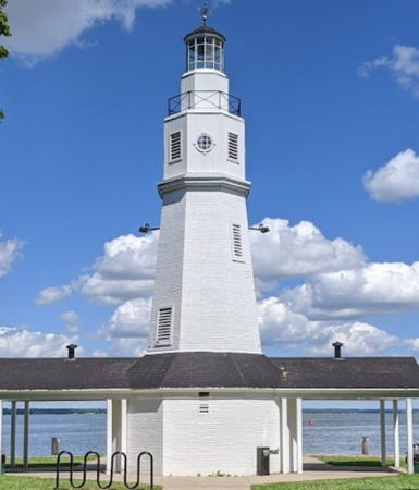
1945. Active (maintained by City of Neenah); focal plane 50 ft (15 m); white flash every 4.5 s. 49 ft (15 m) octagonal brick tower with lantern and gallery, incorporating public restrooms in the base. Tower painted white; lantern roof is black. A photo is at right, Lauro Maia has a closeup, Lee Reese has a 2020 photo, Damien Jourdan has a closeup street view, and Google has a satellite view. Funds to build the lighthouse were contributed by J. C. Kimberly of the Kimberly-Clark Company. Originally 40 ft (12 m) tall, the lighthouse was increased in height in 1954 by the addition of a wood story above the brick. In June 2012 the building was recognized as a state historic site. Located in Kimberly Point Park on Lakeshore Drive at the south side of the entrance from Lake Winnebago into the Fox River (however the navigation channel is actually to the north, on the other side of Doty Island). Accessible by road; parking provided. Site open, tower closed. Owner/site manager: City of Neenah. . ARLHS USA-1070.
* [Asylum Point]
1937. Never active but charted as a landmark. 30 ft (9 m) unpainted round stone tower with lantern. Brian Holzhausen has a 2021 photo, Matt Likwarz has a 2017 photo, Nicole Johnson has a closeup, and Google has a satellite view. The lighthouse was built by the U.S. Works Progress Administration (WPA), but the state rejected it as an aid to navigation and it was never activated. In 2007 the county restored the lighthouse inside and out with new windows and a new roof. Located at Asylum Point north of Oshkosh; accessible from the park entrance at Snell and Sherman Roads. Note however: the intersection of Snell Road and County Route A is completely unmarked. Owner/ site manager: Winnebago County (Asylum Point Park). . ARLHS USA-979.
* Bray's Point (Rockwell)
1910 (William Bray). Active (privately maintained); focal plane about 49 ft (15 m); continuous red light. 42 ft (13 m) octagonal cylindrical brick tower with an ornate open iron lantern. Lighthouse is unpainted cream-colored brick with white stone trim; lantern is greenish weathered iron. There's another page for the lighthouse, Beth McIntyre has a good photo, Troy Holland has a photo, and Google has a satellite view and a distant street view. This light is not charted as an official aid to navigation. It is called the Rockwell lighthouse after its architect, George Andrews Rockwell. The lighthouse was deactivated in the 1950s and fell into disrepair; it was restored and reactivated by new owners in 1986. Located on Bray's Point, at the corner of Lake and Bayshore Streets on the north side of the mouth of the Fox River, near downtown Oshkosh. Site and tower closed, but the lighthouse can be photographed from the street nearby. Owner/site manager: private. . ARLHS USA-1255.
Neenah Light
Neenah Light, Neenah, November 2009
Wikimedia Creative Commons photo by Royalbroil

Fond du Lac County Lighthouses
** Fond du Lac (Lakeside Park)
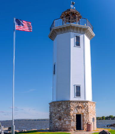
1933 (Roger Sutherland). Active (maintained by City of Fond du Lac); focal plane about 60 ft (18 m); flashing red light. 56 ft (17 m) octagonal wood tower with gallery, painted white, mounted on an octagonal stone foundation; open lantern-like structure at the top; flashing red light mounted on top of the faux lantern. Tower painted white, lantern roof black. A Google Maps street view is at right, Jeri Zimmermann has a 2018 photo, Nick Wilson has a 2021 winter sunset photo, Marinas.com has aerial photos, and Google has a satellite view. The lighthouse was restored in 1968 and in 1993. Historical displays detailing the history of the lighthouse were added in 2016. The lighthouse was closed in September 2021 due to water damage discovered in the interior. In 2022 the city budgeted $200,000 for a restoration project. Work began in September and was expected to continue through spring 2023. Located on the west side of the marina entrance in Lakeside Park at the end of Promen Drive in Fond du Lac. Site open, tower open (pending completion of repairs) to self-guided tours in season. Accessible by road; parking provided. Owner/site manager: City of Fond du Lac (Lakeside Park). . ARLHS USA-925.
* [Fisherman's Road Fishing Club]
Date unknown. Active (privately maintained); focal plane about 25 ft (7.5 m); red light, characteristic unknown. Approx. 25 ft (7.5 m) round barbell-shaped steel tower, painted white. Ed Schneider has a winter sunrise photo and Google has a satellite view. This tower is of a type used for pierhead lights on the Great Lakes. Its original location is not known. For a number of years it stood beside the Columbia Park tower (next entry). In or about 2001 it was relocated about 3 miles (5 km) south to the Fisherman's Road Fishing Club, which has restored and repainted the tower, adding the club logo. Located on the south pier of the marina at the end of Fisherman's Road, west of Kiel. Site open, tower closed. Owner/site manager: Fisherman's Road Fishing Club. .
** Calumet Harbor (Columbia Park, Pipe)
1936. Active (maintained by Fond du Lac County); focal plane about 75 ft (23 m); white flash every 6 s. 70 ft (21 m) square pyramidal steel skeletal tower with gallery, painted brown with white trim. Keith Malson has a 2017 photo, Matthew Werther has a winter 2020 photo, and Google has a satellite view. Originally the water tower of the Fond du Lac Table Factory, the skeletal tower was moved to this site in 1936 by the U.S. Works Project Administration as an observation tower and aid to navigation. It was restored in 1992, at a cost of $98,000, by the Columbia Park Tower Fund and Fond du Lac County. The light marks the entrance to the Calumet Harbor Marina. Located at Calumet Harbor on the southeastern shore of Lake Winnebago about 10 miles (15 km) northeast of Fond du Lac and at the end of County Road W in Pipe. Site and tower open. Owner/site manager: Fond du Lac County (Columbia Park). .

Fond du Lac Light, Fond du Lac, October 2013
Google Maps street view
 

Lake Mendota Lighthouse

Dane County Lighthouse
* Tenney Park Lock
1959. Active; focal plane about 45 ft (14 m); flashing light, alternately red and white. 40 ft (12 m) round steel tower with lantern and gallery. Lighthouse painted white with a red band under the lantern. Corey Coyle's photo is at right, Jim Angus has a 2021 photo, Amanda Werhane has a 2009 photo and Google has a street view and a satellite view. The City of Madison, the capital city of Wisconsin, is built around Lake Mendota and Lake Monona, with the state government buildings being on the isthmus between the two lakes. A lock at Tenney Park, on the south shore of Lake Mendota, allows boats to pass from one lake to the other through a short section of the Yahara River. The lighthouse is located on the west side of the entrance to the lock from Lake Mendota. Site open, tower closed. Site manager: Dane County Parks (Tenney Park Lock and Dam). .

Information available on lost lighthouses:

  • Manitowoc Main (1839-1877), Manitowoc. The lighthouse remained in service as the keeper's house for the pierhead lights until 1935; it was sold into private ownership in 1938 and does not survive. ARLHS USA-1316.
  • Manitowoc North Pierhead (1895-1937), Manitowoc. This lighthouse was destroyed by a storm in 1937 and replaced by a skeletal tower, which has also disappeared.
  • Menasha (1855-1859), entrance to the Fox River from Lake Winnebago. See Anderson's Neenah page. The abandoned lighthouse was destroyed by fire in 1880.
  • Milwaukee North Cut (1866-1875). See Anderson's Milwaukee Pierhead page; he has a historic photo. The lighthouse was demolished.
  • Racine North Pierhead (1849-1902), Racine. This lighthouse was removed.

Notable faux lighthouses:


Tenney Park Lock Light, Madison, September 2014
Google Maps photo by Corey Coyle

Adjoining pages: North: Northeastern Wisconsin | South: Illinois

Return to the Lighthouse Directory index

Checked and revised November 14, 2023. Lighthouses: 24. Site copyright 2023 Russ Rowlett and the University of North Carolina at Chapel Hill.