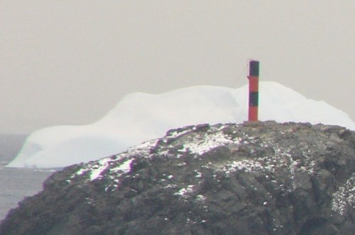
Lighthouses of Antarctica

Surrounding the South Pole, the continent of Antarctica has no permanent population but it has dozens of scientific stations, many of them staffed year round. A few of these stations are visited fairly regularly by adventure cruise ships. The more accessible stations are all located in the region south of Cape Horn (Chile), where the Antarctic Peninsula and South Shetland Islands extend well to the north into waters that can be navigated safely during the summer. This region is claimed by Argentina, Chile, and the United Kingdom. Under the Antarctic Treaty System these claims are suspended indefinitely and all lands south of latitude 60°S are set aside as a scientific and wildlife reserve.

In the Lighthouse Directory navigational beacons are considered to be lighthouses if they have a height of at least 4 meters and a footprint of at least 4 square meters. By this standard Antarctica has no lighthouses. However, this page lists a number of taller beacons that approach lighthouse status. Several of these lights have been described as "the world's southernmost lighthouse." For the record, the southernmost navigational light listed by the Admiralty and NGA is a small beacon at the Argentine station of San Martín, near the base of the Antarctic Peninsula at 68°11.8'S. This is considerably farther south than the other lights listed here.

Lights in the Antarctic are operated by the stations they serve and probably are lighted only when ships are expected.

ARLHS numbers are from the ARLHS World List of Lights. Admiralty numbers are from volume G of the Admiralty List of Lights & Fog Signals. U.S. NGA List numbers are from Publications 110 for the South Orkney Islands and 111 for the South Shetland Islands and Antarctica.

General Sources
Online List of Lights - Band G
Photos by various photographers posted by Alexander Trabas; includes pages for the South Orkney Islands, the South Shetland Islands and for Antarctica.
Lighthouses in Antarctica
Photos by various photographers available from Wikimedia.
World of Lighthouses - Antarctica
Photos by various photographers available from Lightphotos.net.
Lista de Faros Argentinos
Official Argentine Navy lighthouse site, with data and small photos.

Potter's Bay Light
Potter's Bay Light, King George Island, February 2005
anonymous Creative Commons photo
(no longer online)

South Orkney Islands Lighthouse
The South Orkney Islands are located in the sub-Antarctic about 600 km (375 mi) northeast of the tip of the Antarctic Peninsula. The islands are claimed by Argentina and Britain, but they lie within the region where all claims are suspended by the Antarctic Treaty. Argentina established a base on Laurie Island in 1904 and has maintained it year round ever since. The British base on Signy Island was established in 1947 and is currently staffed only during the Antarctic summer.

Argentina: Punta Davis (Point Davis)
Date unknown. Active; focal plane unknown; white flash every 5 s. 4 m (13 ft) fiberglass tower colored red with a white horizontal band. No photo available but Bing has a satellite view. Located on a promontory at the eastern entrance to Scotia Bay on Laurie Island. Site open, tower closed. Operator/site manager: Argentine Navy. Admiralty G1379; NGA 110-20363.1.
Argentina: Destacamento (Base Orcadas)
Date unknown. Active; focal plane 12 m (39 ft); white flash every 3 s. Light mounted on a communications tower. Probably the light is on the tower seen left of center in a photo of the Argentine base, but the tower is not seen in Google's satellite view of the base. Located at Argentina's Orcadas Base at the head of Scotia Bay on Laurie Island. Site open, tower closed. Operator/site manager: Argentine Navy. Admiralty G1378.5; NGA 110-20363.2.
Argentina: Navidad
Date unknown. Active; focal plane unknown; white flash every 2 s. 3 m (19 ft) fiberglass tower colored white with a red top. No photo available but the lantern casts a long shadow in Bing's satellite view. Located on the west side of Scotia Bay. Operator/site manager: Argentine Navy. Admiralty G1378; NGA 110-20363.
Great Britain: Signy Island
Date unknown. Inactive since 2018. 12 m (39 ft) skeletal tower. The tower is on the distant bluff in a photo (third row, left) of the British Signy Research Station but it is not seen in Google's satellite view. Located on the east side of Signy Island, southernmost of the South Orkneys. Site open, tower closed. ARLHS SOI-001; ex-Admiralty G1375; ex-NGA 110-20362.

South Shetland Islands Lighthouses
King George Island is the largest of the South Shetland Islands, lying about 120 km (75 mi) north of the Antarctic Peninsula. The island is 95 km (59 mi) long and 25 km (16 mi) wide. Wikipedia has a map showing the location of 9 scientific stations, established by 8 different countries; all are on the more-protected southwestern side of the island. The island is claimed by Argentina, Chile, and Great Britain, but all these claims are suspended by the Antarctic Treaty.
Brazil: Martel Inlet (Comandante Ferraz) (2)
2007 (station established 1984). Active; focal plane about 20 m (66 ft); red light, 1 s on, 1 s off. Approx. 8 m (26 ft) square skeletal tower with gallery, painted red. Wikimedia has a view from the sea, a view of the station shows the light in the left distance, and the light is in the far left in another view, but Google has only a fuzzy satellite view of the base area. Located at Brazil's Comandante Ferraz Station, at the north end of Admiralty Bay, a large embayment on the south side of King George Island. The station was established in 1984 but had to be abandoned after a disastrous fire in February 2012. A new station was activated in 2020 and is staffed year round. Site manager: PROANTAR. Admiralty G1387.5; NGA 111-2729.
Poland: Arctowski (King George Island, Point Thomas)
Date unknown (scientific station established 1977). Active; focal plane 18 m (59 ft); white light, 3 s on, 6 s off. 11 m (36 ft) round cylindrical tower with a small lantern and gallery. The upper half of the light is painted white and the lower half red (the color pattern of the Polish flag). A photo is at right. The lighthouse was originally painted with red and white horizontal bands, as seen in Douglas Cameron's photo posted by Trabas, but it appeared all white in Ted Smith's 2007 photos. Wikimedia has several additional photos but the light is not seen in Google's satellite view. This lighthouse guides vessels to Poland's Henryk Arctowski station, located on the west side of Admiralty Bay. The station is staffed year round. This is one of the stations most frequently visited by Antarctic adventure cruises. Site and tower closed. Site manager: Polish Academy of Sciences. ARLHS SSI-001; Admiralty G1387.4; NGA 111-2728.
Argentina: Carlini (Potter's Bay, Jubany)
Date unknown (scientific station established 1982). Active; focal plane 11 m (36 ft); white flash every 10 s. 9 m (30 ft) round hourglass-shaped tower, painted with red and yellow horizontal bands. A photo appears at the top of this page, Trabas has a closeup photo, Ge Nielissen has a photo, and Bing has a satellite view. Carlini Base (formerly Jubany Base) is an Argentine station located on Isla 25 de Mayo, an island off the entrance to Potter's Bay on the southwestern coast of King George Island. (The station buildings appear in the right background of the photo above.) The station is staffed year round. Site status unknown. Site manager: Argentine Navy. ARLHS SSI-003; Admiralty G1387.7; NGA 111-2725.
Argentina: Cámara (Tres Hermanos)
Date unknown (scientific station established 1982). Active; focal plane 18 m (59 ft); white flash every 10 s. 9 m (30 ft) round barbell-shaped tower, painted with black and yellow horizontal bands. Trabas has a photo and Bing has a satellite view. Located on an island about 1 km (0.6 mi) west of the Potter's Bay light (previous entry). Accessible only by boat. Site status unknown. Site manager: Argentine Navy. ARLHS SSI-004; Admiralty G1387.6; NGA 111-2724.


Arctowski Light, King George Island, April 2013
Wikimedia Creative Commons photo by Marlena1666

 
Uruguay: Jasper Point (Suffield Point, Base Artigas)
Date unknown (scientific station established 1984). Active; focal plane 52 m (171 ft); white flash every 5 s. 5 m (17 ft) round aluminum tower, painted with red and white horizontal bands. No photo available and the light is not easy to find in Google's satellite view. The light guides vessels arriving at Uruguay's Base Artigas, near the southwestern tip of King George Island. The station is staffed year round. Located on a promontory about 800 m (1/2 mi) south of the base. Site status unknown. Site manager: Instituto Antártico Uruguayo. Admiralty G1387.8; NGA 111-2722.
[Chile: Ardley Cove]
Date unknown (scientific station established 1969). Active; focal plane 5 m (17 ft); white flash every 5 s. 3 m (10 ft) post with side panels, painted white with a red horizontal band. Koni Bei has a photo and Google has a satellite view. This small beacon is on the shoreline at the Chilean Eduardo Frei Montalva Station, a short distance south of Uruguay's Base Artigas. The station is staffed year round. Site manager: Instituto Antártico Chileno. Admiralty G1387.9; NGA 2721.
Chile: Ardley Island
Date unknown. Active; focal plane 45 m (148 ft); white flash every 10 s. 6 m (20 ft) round tower on a conical base, painted with orange and black horizontal bands. Ersan Basar has the closeup photo at right and Bing has a satellite view. Ardley Island, known for its large penguin rookery, is about 2.5 km (1.5 mi) long and lies perpendicular to the southwestern peninsula of King George Island. Located at the eastern end of the island. Site status unknown. Site manager: Instituto Antártico Chileno. Admiralty G1388; NGA 111-2720.
Chile: Punta Prat (Robert Island)
Date unknown (scientific station established 1954). Active; focal plane 25 m (82 ft); white flash every 10 s. 7 m (23 ft) round fiberglass tower colored with yellow and orange bands. No photo available and the light is not seen clearly in Google's satellite view. The light guides vessels to Chile's Risopatrón Base. Located on the southern tip of Robert Island, southwest of King George Island. Site status unknown. Site manager: Instituto Antártico Chileno. Admiralty G1386; NGA 111-2732.

Ardley Island Light, King George Island, February 2019
Google Maps photo by Ersan Basar
Argentina: Surgidero Iquique (Deception Island, Buen Suceso)
Date unknown. Active; focal plane 114 m (374 ft); white flash every 5 s. 4.5 m (15 ft) tower, painted with orange and white horizontal bands. No photo available but Google has a satellite view. The light helps guide vessels to Argentina's Base Decepción. Deception Island is at the southern end of the South Shetland Islands. It is the caldera of an active volcano; the drowned caldera, known as Port Foster, provides a completely sheltered anchorage connected to the sea by a narrow passage known as Neptune's Bellows for its strong tidal currents. The British established a base in 1944 and Chile followed with a base of 1955, but these bases were abandoned after the volcano erupted in 1967-69. Currently only Argentina and Spain have scientific stations on the island. Located on the caldera rim of the west side of the island. Site status unknown. Site manager: Argentine Navy. ARLHS SSI-002; Admiralty G1383; NGA 111-2743.

Antarctic Peninsula Lighthouses
Argentina: Esperanza (Grunden Rock, Hope Bay) (3)
1993 (station established 1952). Active; focal plane 26 m (85 ft); white flash every 2 s. 6 m (20 ft) round cylindrical tower, painted with red and black horizontal bands. One of Ted Smith's photos is at right, Trabas has Douglas Cameron's photo, the Argentine Navy has a photo, and Google has a satellite view. The light guides ships arriving at Esperanza Base, a major Argentina station located at Hope Bay at the tip of the Antarctic Peninsula. The station is staffed year round and includes several families; it has a year round population of about 50. The settlement is a frequent stop for adventure cruises to the Antarctic. Located on an islet about 1.1 km (0.7 mi) east of the base. Accessible only by boat. Site and tower closed. Site manager: Argentine Navy. ARLHS ANC-002; Admiralty G1389; NGA 111-2756.
Grunden Rock Lighthouse
Grunden Rock Light, Base Esperanza, Antarctica, 2007
photo copyright Ted Smith; used by permission
Argentina: Primero de Mayo (Melchior Base)
1942. Active (?); focal plane 27 m (89 ft); white flash every 8 s. 11 m (36 ft) triangular pyramidal skeletal tower painted red and carrying an orange slatted daymark. This is the oldest Antarctic lighthouse. Wikimedia has several photos, the Argentine Navy has a photo, another photo ia available, and Google has a very distant satellite view of the base. Located at Melchior Base on Observatory Island, a small island in the Melchior Islands in Dallman Bay. The station is staffed only in the summer. Site and tower closed. Site manager: Argentine Navy. Not listed by the Admiralty. ARLHS ANC-001.
Chile: Condell (Lautaro Island)
2015 (?). Active; focal plane 18 m (59 ft); white flash every 5 s. Approx. 6 m (20 ft) fiberglass tower colored white with a broad red horizontal band. Trabas has Jim Smith's photo and Google has a satellite view. NGA lists the tower height as 3 m (10 ft) but it appears taller in the photo. Located at the northe end of a small island in the Gerlach Strait, the approach to Chile's Base Yelcho. Site and tower closed. Site manager: Instituto Antártico Chileno. Admiralty G1398; NGA 111-2784.
Great Britain: Port Lockroy
Date unknown. Inactive. Approx. 14 m (46 ft) square skeletal tower. A photo is available and Google has a satellite view. Port Lockroy is a former 19th century whaling station and also the site of a British scientific station staffed between 1944 and 1962. It is now operated as a historic site and is a popular stop for adventure cruise ships. Located on the northwest side of Wiencke Island, the southernmost island of the Palmer Archipelago off the west side of the Antarctic Peninsula. Site open, tower closed.
Chile: Doumer Island (Py Point, Base Yelcho)
2015 (?) (scientific station established 1962). Active; focal plane 71 m (233 ft); white flash every 5 s. 11 m (36 ft) square pyramidal skeletal tower. Tom Chisholm's photo is at right and Google has a satellite view. This tower guides vessels approaching the nearby Base Yelcho. The base reopened in 2015 after being abandoned in 1998. Located at the western tip of Doumer Island. Site and tower closed. Site manager: Instituto Antártico Chileno. Admiralty G1399.4; NGA 111-2788.

Doumer Island Light, Antarctica, 2018
photo copyright Tom Chisholm; used by permission
Argentina: Base San Martín
Date unknown. Active; focal plane 18 m (59 ft); white flash every 5 s. 4 m (13 ft) round fiberglass tower colored red with a black top. No photo available and the light is not seen in Google's satellite view. This is the southernmost light listed by the Admiralty and NGA. Located on an island in the approach to Argentina's Base San Martín. The base was opeated from 1951 to 1960 and then reopened as a permanent base in 1976. Located on an island in Marguerite Bay near the west side of the base of the Antarctic Peninsula. Site manager: Argentine Navy; Admiralty G1401.7; NGA 111-2795.

Information available on lost lighthouses:

Notable faux lighthouses:

Adjoining page: North: Chile: Magallanes

Return to the Lighthouse Directory index | Ratings key

Posted December 14, 2007. Checked and revised July 25, 2023. Lighthouses: 18. Site copyright 2023 Russ Rowlett and the University of North Carolina at Chapel Hill.