Lighthouses of Canada: Northern British Columbia

The territory of British Columbia was originally part of the Oregon Country, the area west of North America's Continental Divide between latitudes 42° and 54°40' North. In the London Convention of 1818 the U.S. and Britain agreed to joint occupation of this territory. The Oregon Treaty of 1846 confirmed British occupation of Vancouver Island and the rest of what became British Columbia; it also set the boundary between the U.S. and British territory at latitude 49° between the Rocky Mountains and the Strait of Georgia. In 1849 the Colony of Vancouver Island was organized, and in 1858 the southern mainland was organized as the Colony of British Columbia. Vancouver Island was merged with British Columbia in 1866 and the enlarged colony assumed its present boundaries.

The nation of Canada was created by the British North America Act in 1867 with Ontario, Québec, New Brunswick, and Nova Scotia as the four original provinces. Manitoba was established as the fifth province in 1870 and British Columbia joined as the sixth province in 1871. Today Canada has ten provinces and three large federal territories in the Arctic.

The rugged and intricate coastline of British Columbia has about 40 surviving lighthouses. Unlike the situation in eastern and central Canada, a fair fraction of these light stations are still staffed: Ron Ammundsen, the principal keeper at Quatsino Light, lists 27 staffed light stations in the province. Some of these stations represent the only federal presence in remote and roadless areas of the coast. There was an uproar in 2010-11 when the government proposed destaffing all the stations to save money; eventually the destaffing plan was dropped.

This page includes lighthouses of the Inside Passage and the Haida Gwaii (Queen Charlotte) Islands. The Inside Passage is the network of waterways behind and between the numerous islands of the Pacific coast from Vancouver Island northward into Alaska. Nearly all of the Passage is sheltered from Pacific storms by the islands but strong tidal currents and many underwater obstacles make it hazardous to navigate. Ferries and cruise ships sailing the passage are the principal means of surface transportation everywhere along this coast. Most of the lighthouses in this group can be photographed at close range from passing cruise ships. The listing here is south to north.

Aids to navigation in Canada are maintained by the Canadian Coast Guard. In 2008 Parliament passed the Heritage Lighthouse Protection Act to designate and protect historic lighthouses.

ARLHS numbers are from the ARLHS World List of Lights. CCG numbers are from the Pacific Coast volume of the List of Lights, Buoys, and Fog Signals of Fisheries and Oceans Canada. Admiralty numbers are from volume G of the Admiralty List of Lights & Fog Signals. For lights close to the U.S. border USCG numbers are from volume 6 of the U.S. Coast Guard List of Lights, and U.S. NGA numbers are from Publication 111.

General Sources
Lighthouses of British Columbia, Canada
Photos, historical accounts, and travel directions for the more accessible lighthouses, posted by Kraig Anderson.
Neal's Lighthouse Blog: BC
Photos and comments by Neal Doan.
Online List of Lights - Canada Pacific Coast
Photos by various photographers posted by Alexander Trabas. Most of the photos for the Inside Passage are by Günther Hess, Rainer Arndt or Jim Smith.
Lighthouses in British Columbia
Photos by various photographers available from Wikimedia.
Lighthouses of British Columbia
Wonderful photos by Mike Mitchell.
World of Lighthouses - Pacific Coast of Canada
Photos by various photographers available from Lightphotos.net.
Lighthouses in British Columbia, Canada
Aerial photos posted by Marinas.com.
Leuchttürme Kanadas auf historischen Postkarten
Historic postcard views posted by Klaus Huelse.
List of Lights, Buoys, and Fog Signals
Official Canadian light lists are available in both pdf and html formats.
GPSNavigationCharts
Navigation chart information for the Canadian west coast.
Navionics Charts
Navigation chart for the Canadian west coast.


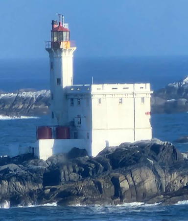
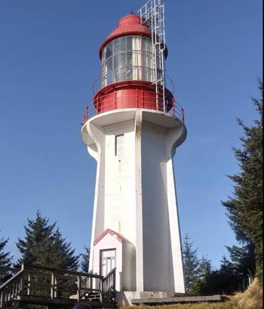
Cape Mudge Light, Quadra Island, September 2019
Instagram photo by Scott Adam Vincent-Campello
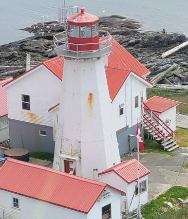

Green Island Light, Prince Rupert, June 2022
Google Maps photo by Ed Trowell
Inside Passage Lighthouses

Strathcona Regional District (Discovery Islands) Lighthouses
This southern section of the Inside Passage includes the Discovery Passage and Johnstone Strait, narrow passages separating Vancouver Island from the Discovery Islands and the mainland.

*
[Pine Island (1) (lantern)]
1907. Inactive since 2001. The historic lantern of the Pine Island lighthouse (see below) is mounted on a square wood faux lighthouse attached to the front of the Campbell River Maritime Heritage Centre in Campbell River. A photo is available and Google has a street view and a satellite view. Located on the Island Highway (BC 19A) at 6th Avenue, adjacent to the marina in Campbell River. Site open, museum open daily year round, tower closed.
* Cape Mudge (Quadra Island) (2)
1916 (station established 1898). Active; focal plane 17.5 m (58 ft); continuous red or white light, depending on direction, with a more intense flash every 5 s. 12 m (40 ft) octagonal concrete tower with lantern and gallery, painted white; lantern and gallery painted red. Fog horn (3 s blast every 30 s). Staffed light station with two 2-story red-roofed keeper's houses and other buildings. Scott Adam Vincent-Campello's photo is at the top of this page, C.M. Hanchey has a photo, a 2022 photo is available, Mitchell has a closeup, Trabas has Smith's closeup photo, Marinas.com has aerial photos, and Google has a street view and a satellite view of the station. The original lighthouse was a 2-story keeper's house with a lantern on the roof. In September 2009 the government announced that the station would be destaffed to cut costs; after public protests this plan was dropped. The lighthouse marks the entrance from the broad Strait of Georgia to the Discovery Passage, the first narrow section of the Inside Passage. Located in Cape Mudge Village at the southern end of Quadra Island (accessible by ferry from BC 19 in Campbell River). Site open; tower is sometimes open to guided tours during the summer (inquire locally). Owner/site manager: Canadian Coast Guard. . ARLHS CAN-100; CCG P-0511, Admiralty G5580, NGA 12560.
[Chatham Point (2)]
1957 (station established 1908). Active; focal plane 6.5 m (21 ft); green flash every 5 s. 4.5 m (15 ft) round cylindrical steel tower, painted white with a green band at the top; no lantern. This is a staffed light and weather station with two 1-story keeper's houses and other buildings. Fog horn (2 s blast every 20 s). Trabas has a photo by Jeffrey James and Google has a satellite view of the station. Located about 40 km (25 mi) north of Campbell River on the west side of the Inside Passage, where the route takes a sharp turn from the Discovery Passage into the Johnstone Strait. Land access from Chatham Point Road is probably closed to the public, so the light is best seen by boat. Site and tower closed. Owner/site manager: Canadian Coast Guard. ARLHS CAN-132; CCG P-0518, Admiralty G5590, NGA 12508.

Mount Waddington Regional District (Queen Charlotte Strait) Lighthouses

Queen Charlotte Strait
is a relatively broad passage along the north coast of Vancouver Island, connecting the narrow Broughton Strait to Queen Charlotte Sound.
Haddington Reefs Pier
Date unknown. Active; focal plane 9 m (30 ft); red light, 1 s on, 1 s off. 9 m (30 ft) two-stage tower, a round tower atop a square tower, with two galleries, mounted on a round concrete pier. Lighthouse painted white with a red band at the top. Trabas has Rainer Arndt's photo and Google has an indistinct satellite view. Located on the north side of the Broughton Strait channel south of Malcolm Island and across from Haddington Island. Accessible only by boat. CCG P-0550.2, Admiralty G5624, NGA 12348.
* Pulteney Point (Sointula) (2)
1943 (station established 1905). Active; focal plane 12 m (40 ft); red flash every 10 s. 9 m (30 ft) square cylindrical concrete tower with lantern and gallery, attached to a 1-story fog signal building. Lighthouse painted white; lantern and gallery painted red. Fog horn (three 2 s blasts every 60 s). This is a staffed light station with a keeper's house and other buildings. David Britton's photo is at right, Anzor Krestov has a 2017 photo, Trabas has a small photo by Rainer Arndt, Marinas.com has aerial photos, and Google has a satellite view. Anderson has a Coast Guard historic photo of the original lighthouse. Sointula, the alternate name for the lighthouse, is the name of a nearby settlement founded by Finnish immigrants in 1901. For southbound vessels this lighthouse marks the entrance to the narrow Broughton Strait from Queen Charlotte Strait. Although it is remote this station is accessible by a 10-15 minute walk from the west end of the gravel road running the length of Malcolm Island, which is accessible by ferry from BC 19 at Port MacNeill. Located on the west end of Malcolm Island. Site open, tower closed. Owner/site manager: Canadian Coast Guard. . ARLHS CAN-420; CCG P-0553, Admiralty G5628, NGA 12328.

Pulteney Point Light, Malcolm Island, September 2021
Google Maps photo by David Britton
Scarlett Point (3)
Date unknown (station established 1905). Active; focal plane 24 m (78 ft); white flash every 5 s. 11 m (37 ft) round steel tower with lantern and gallery, flared at the top, painted white; octagonal lantern painted red. Staffed light station with 1-story keeper's house, fog signal building, and other buildings. C.M. Hanchey's photo is at right, a 2007 distant view and a 2006 aerial view are available, Trabas has Rainer Arndt's photo, Marinas.com has aerial photos, and Google has a satellite view. Anderson has a Coast Guard historic photo of the original lighthouse; it was demolished after being replaced by a skeletal tower in 1965. In 2020 keeper Ivan Dubinsky announced his retirement after winning $1 million in the provincial lottery. Located on the northeastern point of Balaklava Island, an island off the north coast of Vancouver Island about 15 km (10 mi) northwest of Port Hardy. Accessible only by boat, but easily seen from passing ships. Site open, tower closed. Owner/site manager: Canadian Coast Guard. ARLHS CAN-450; CCG P-0570, Admiralty G5648, NGA 12268.
Pine Island (3)
2001 (station established 1907). Active; focal plane 28 m (93 ft); red flash every 10 s. Round cylindrical steel tower, painted white, without lantern. Staffed light station with one 2-story and two 1-story keeper's house and other buildings. The original lantern, lens, and fog horns are on display at the Campbell River Maritime Heritage Centre in Campbell River. Trabas has Rainer Arndt's photo, Ken Lundy has a 2022 photo (misidentified as Scarlett Point), Marinas.com has aerial photos, and Bing has a satellite view. The 1907 lighthouse was a square wood tower at one corner of a keeper's house. It was replaced by a 10.5 m (35 ft) square cylindrical steel tower with lantern, gallery, and square pyramidal skeletal bracing. That lighthouse was repaired after the station was heavily damaged by a giant wave during a storm in February 1967. The present light replaced the second lighthouse, which was repaired after the 1967 storm. The island is a wildlife preserve for nesting sea birds. Located on a small island in the middle of the entrance to Queen Charlotte Strait from Queen Charlotte Sound. Accessible only by boat, but easily seen from passing ships. Site and tower closed. Owner/site manager: Canadian Coast Guard. ARLHS CAN-382; CCG P-0576, Admiralty G5649, NGA 12252.

Scarlett Point Light, Mt. Waddington Region, August 2010
Lightphotos.net photo copyright C.M. Hanchey; used by permission

Central Coast Regional District (Queen Charlotte Sound and Bella Bella Area) Lighthouses
Queen Charlotte Sound is the section of the Pacific Ocean between Vancouver Island and the Haida Gwaii (Queen Charlotte) Islands. Here the protection for the Inside Passage disappears and ships are exposed to the open ocean for about 50 km (30 mi). With a population of 1200 Bella Bella (Waglisla) is the largest settlement on the coast between Queen Charlotte Sound and Prince Rupert. The town has a sheltered location on the east side of Campbell Island; ships on the Inland Passage must negotiate several tight turns and narrow straits to pass the town.

Cape Caution
Date unknown. Active; focal plane 21 m (70 ft); white flash every 6 s. 8.5 m (28 ft) square white skeletal tower mounted on concrete footings. Trabas has a very distant view by Günther Hess, and Google has an indistinct satellite view. Located on a prominent cape on the north side of the entrance to Queen Charlotte Strait. Accessible only by boat. Site open, tower closed. CCG P-0578; Admiralty G5656, NGA 12220.
Egg Island (3)
1964 (station established 1898). Active; focal plane 88 m (290 ft); white flash every 5 s. 26 m (85 ft) square pyramidal skeletal tower. Staffed light station with two keeper's houses, fog signal building, and other structures. Trabas has a distant view from the sea by Günther Hess, Rob Nemlander also has a distant view from the sea, and Google has a satellite view of the station. The 1898 lighthouse, a square wood tower attached to a keeper's house, was relocated to a higher elevation in 1903 because of danger from storm waves. Despite this move, it was destroyed by the enormous waves of a storm on 2 November 1948. A new lighthouse, with a square concrete tower attached to one corner of a keeper's house, was built in 1949. Anderson has historic photos of the original and 1949 lighthouses, and the Lighthouse Digest photo is of the original lighthouse. Located on an island in the center of the passage across Queen Charlotte Sound about 10 km (6 mi) north of Cape Caution on the eastern shore of Queen Charlotte Sound. Accessible only by boat, but easily seen from passing ships. Site open, tower closed. Owner/site manager: Canadian Coast Guard. ARLHS CAN-740; CCG P-0579, Admiralty G5658, NGA 12216.
Addenbroke Island (3)
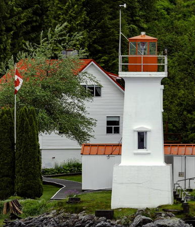
1998 (station established 1914). Active; focal plane 24 m (79 ft); white flash every 5 s. 8 m (26 ft) round concrete tower, painted white. Staffed light station with two keeper's houses, fog signal building, and other structures. C.M. Hanchey's photo is at right, Trabas has a photo by Günther Hess, David Stanley has a 2021 photo, and Google has a satellite view of the station. The original lighthouse was replaced by a steel skeletal tower in 1968. Located on an island in Fitz Hugh Sound, on the east side of Calvert Island about 100 km (60 mi) north of Port Hardy and a similar distance southwest of Bella Coola. Accessible only by boat, but easily seen from passing ships. Site open, tower closed. Owner/site manager: Canadian Coast Guard. ARLHS CAN-004; CCG P-0585, Admiralty G5672, NGA 12192.

Addenbroke Island Light, Central Coast Region, August 2010
Lightphotos.net photo copyright C.M. Hanchey; used by permission
[Pointer Island (2)]
1989 (station established 1899). Active; focal plane 13 m (43 ft); white light, 4 s on, 2 s off. 8 m (26 ft) round cylindrical white tower. Trabas has Smith's photo, Lightphotos.net has C.M. Hanchey's photo, and Google has an indistinct satellite view. Anderson has a historic photo of the original lighthouse. This light marks a right-angled turn from Fitz Hugh Sound into the narrow Lama Passage. Located on a small island off the northeastern tip of Hunter Island. Accessible only by boat, but easily seen from passing ships. Site open, tower closed. Owner/site manager: Canadian Coast Guard. ARLHS CAN-400; CCG P-0592; Admiralty G5680, NGA 12168.
Dryad Point (Bella Bella) (2)
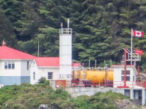
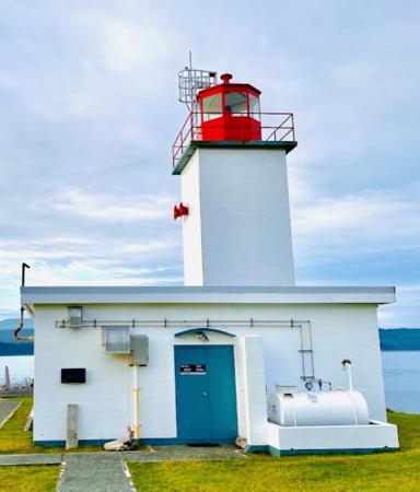
1919 (station established 1899). Active; focal plane 11.5 m (38 ft); white or red light, depending on direction, occulting every 5 s. 8.5 m (28 ft) square concrete tower with lantern and gallery. Lighthouse painted white, lantern red. Staffed light station with two keeper's houses, fog signal building, and other structures. Michael McNerney's photo is at right, C.B. Curran has a photo, Nigel Walsh has a photo, Trabas has a photo by Günther Hess, Lighthouse Digest has a closeup by Chris Mills, A. Kafka has a photo, James Teresco has posted additional photos, and Google has a satellite view of the station. This small lighthouse is a familiar landmark on the Inside Passage because ships must slow down and make a tight turn around the point. In September 2009 the government announced that the station would be destaffed to cut costs; this plan was later abandoned. Located on the northeast point of Campbell Island about 3 km (2 mi) north of Bella Bella. Accessible only by boat, but easily seen from passing ships. Site open, tower closed. Owner/site manager: Canadian Coast Guard. . ARLHS CAN-163; CCG P-0611, Admiralty G5700, NGA 12072.
Ivory Island (1)
1898. Inactive since 1957. 2-story square wood keeper's house; the lantern, formerly located at the peak of the roof, was removed in 1957. Lighthouse painted white; the roof is red. This is a rare surviving original building among the early lighthouses of the Inside Passage. Anderson has a historic photo of the house when it was an active lighthouse.
Ivory Island (3)
1983 (station established 1898). Active; focal plane 20 m (67 ft); white flash every 5 s. 5 m (17 ft) square pyramidal steel skeletal tower mounted on a platform attached to a 1-story fog signal building; no lantern. Tower painted red. Staffed light station with two keeper's houses and other buildings. Wikimedia has two photos, Trabas has a photo by Charles Bash, and Google has a satellite view. In 1957 the light was moved from the original lighthouse to a steel skeletal tower, which collapsed when the station was inundated by a powerful storm on Christmas Day 1982. Located on the south side of the island in the entrance to the Seaforth Channel from Milbanke Sound, about 15 miles northwest of Bella Bella. Accessible only by boat, but easily seen from passing ships. Site open, tower closed. Owner/site manager: Canadian Coast Guard. ARLHS CAN-252; CCG P-0617, Admiralty G5713, NGA 12052.

Dryad Point Light, Bella Bella, June 2017
Google Maps photo by Michael McNerney

Kitimat-Stikine Regional District (Klemtu Area) Lighthouses
McInnes Island (2)
1954 (station established 1921). Active; focal plane 30 m (98 ft); white flash every 5 s. 9 m (30 ft) square cylindrical concrete tower with lantern and gallery, attached to a 1-story keeper's house. Lighthouse painted white, lantern red. Staffed light station with 2-story crew house and other buildings. Lighthouse Digest has a Coast Guard photo, Trabas has Arndt's view from the sea, and Bing has a satellite view of the station. Located on the south side of a small island off the southern tip of Price Island, marking the northern entrance to Milbanke Sound about 50 km (30 mi) west of Bella Bella. Accessible only by boat. Site open, tower closed. Owner/site manager: Canadian Coast Guard. ARLHS CAN-310; CCG P-0619, Admiralty G5715, NGA 12040.
Boat Bluff (3?)
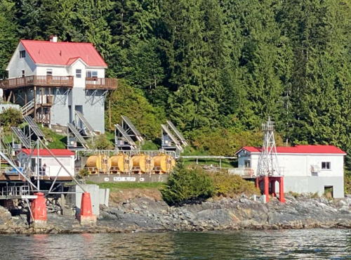
Date unknown (station established 1907). Active; focal plane 11.5 m (38 ft); white or red light, depending on direction, occulting every 5 s. 7 m (24 ft) square pyramidal steel skeletal tower mounted on a square base having four legs. Tower painted white, base red. Staffed light and weather station with two 2-story keeper's houses, fog signal building, and other buildings. Dwane MacIsaac's 2023 photo is at right, Trabas has a photo by Günther Hess, Wikimedia has two photos, a closeup of the light tower is available, Lighthouse Digest has Jeremy D'Entremont's November 2003 feature article on the light station, and Google has a satellite view of the station. Located directly on the Inside Passage on the west side of Sarah Island, marking the northbound entrance to the narrow Sarah Passage, about 5 km (3 mi) north of the village of Klemtu. Accessible only by boat, but easily seen from passing ships, which must make a sharp turn here if they wish to use the Sarah Passage and Tolmie Channel. Site open, tower closed. Owner/site manager: Canadian Coast Guard. . ARLHS CAN-048; CCG P-0640, Admiralty G5720, NGA 12000.

Boat Bluff Light Station, Klemtu, September 2023
Instagram photo by Dwane MacIsaac

Skeena-Queen Charlotte Regional District: Prince Rupert Area Lighthouses
Prince Rupert has a population of about 12,500 and is the northernmost town of Canada's Pacific coast. The town is accessible by road via the Yellowhead Highway (BC 16).

#Lawyer Islands (3)
Early 1960s (station established 1901). Inactive since about 2007 and demolished sometime before 2011. This was a 20 m (65 ft) square steel skeletal tower, painted white. The original lighthouse at this station was a square wood tower attached to a keeper's house. Mariners complained that the light was too low, so it was replaced in 1909 by an octagonal wood tower at a higher elevation. The skeletal tower that replaced the historic lighthouses in the early 1960s became a landmark for travelers on the Inside Passage. Around 2007 the light was replaced by two smaller beacons at the north and south ends of the island (CCG P-0685.3 and 0684.5). Located on an island about 25 km (15 mi) south of Prince Rupert. Accessible only by boat. Site status unknown. Owner/site manager: Canadian Coast Guard. ARLHS CAN-272; ex-CCG P-0685, ex-Admiralty G5770, ex-NGA 11748.
Holland Rock (4)
1949 (station established 1908). Active; focal plane 7 m (23 ft); three white flashes, separated by 2 s, every 12 s. 6 m (20 ft) square cylindrical steel skeletal tower mounted atop a 1-story fog signal building. Entire lighthouse painted white. Trabas has a photo by Günther Hess and Bing has a satellite view. An acetylene beacon placed on Green Top Island in 1906 was moved here in 1908. A lighthouse with a square tower rising from a 2-story keepers house was built in 1913. It served until it was destroyed by fire in 1946. The present light is built on the stone pier of the 1913 lighthouse. Anderson has historic photos of the 1908 beacon and 1913 lighthouse. The third light was on a skeletal tower; the fog signal building carrying the present light was built in 1949. Located on an isolated rock in Chatham Sound about 15 km (10 mi) south of Prince Rupert. Accessible only by boat but easily seen from passing ships. Site and tower closed. Owner/site manager: Canadian Coast Guard. ARLHS CAN-229; CCG P-0690, Admiralty G5772, NGA 11704.
Lucy Islands (2)
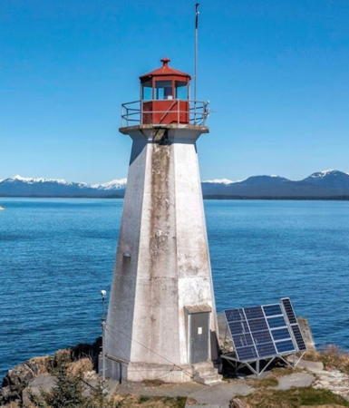
1960 (station established 1907). Active; focal plane 21.5 m (71 ft); red flash every 6 s. 10.5 m (35 ft) octagonal concrete tower with lantern and gallery, painted white; lantern and gallery painted red. Keeper's house demolished in 1988. Lonnie Wishart's 2023 photo is at right, Miguel Borges has a photo, Mitchell has a good photo, a closeup is available, Lighthouse Digest has a Coast Guard photo, and Bing has a satellite view. Anderson has a historic photo of the original lighthouse. Located at the northeastern tip of the islands, about 15 km (10 mi) west of Prince Rupert, marking the start of the Metlaketla Channel leading to Prince Rupert Harbour. Accessible only by boat but easily seen from passing ships. Site and tower closed. Owner/site manager: Canadian Coast Guard. ARLHS CAN-290; CCG P-0719; Admiralty G5807; USCG 6-21770; NGA 11604.
Butterworth Rocks
Date unknown. Active; focal plane 18 m (59 ft); white flash every 6 s. 13 m (43 ft) square skeletal tower atop a square stone tower. Trabas has Arndt's view from the sea and Bing has a satellite view. Located on a rocky islet about 12 km (7.5 mi) southwest of the Triple Islands lighthouse (next entry).Accessible only by boat in dangerous seas. Site open, tower closed. CCG P-0751; Admiralty G5811; NGA 11468.

Lucy Islands Light, Prince Rupert, August 2023
Google Maps photo by Lonnie Wishart
Triple Islands
1920. Active; focal plane 28 m (92 ft); two white flashes, separated by 2.5 s, every 9 s. 22 m (72 ft) octagonal cylindrical concrete tower with lantern and gallery, attached to a 2-story concrete keeper's house. 3rd order Fresnel lens in use. Staffed light station with helipad. A photo by Neki Kins is at right, Trabas has Arndt's photo, Paul Carroll has a good photo, Lighthouse Digest has Alec Provan's photo, Mitchell also has a good photo, Wikimedia has a 2021 photo, and Bing has a satellite view. Located on the northwesternmost of three rocky islets marking the entrance to the Brown Passage, which leads from the Dixon Entrance to Prince Rupert, about 40 km (25 mi) west of the town. Accessible only by boat in dangerous seas or by helicopter. Site and tower closed. Owner/site manager: Canadian Coast Guard. ARLHS CAN-508; CCG P-0752, Admiralty G5812, NGA 11460.
Barrett (Barret) Rock
Date unknown. Active; focal plane 7 m (23 ft); red flash every 6 s. 7 m (23 ft) round white tower atop a square stone tower. Trabas has a closeup photo by Günther Hess and Google has a satellite view. Located on the east side of the entrance to Prince Rupert Harbour. Accessible only by boat. Site open, tower closed. Owner/site manager: Canadian Coast Guard. ARLHS CAN-020; CCG P-0703, Admiralty G5794, NGA 11624.
Green Island (2)
Date unknown (station established 1906). Active; focal plane 19 m (63 ft); white flash every 5 s. 10.5 m (35 ft) octagonal pyramidal concrete tower with lantern and gallery, painted white; lantern and gallery painted red. Staffed light station with at least two keeper's houses and other buildings. Ed Trowell's drone view is at the top of this page, Chad Graham has an excellent closeup, Ed deJong has a 2010 photo of the station, and Bing has a satellite view of the station. Located on a small island off the northeastern tip of Dundas Island, about 40 km (25 mi) northwest of Prince Rupert and about 5 km (3 mi) south of the Alaskan border. Accessible only by boat, but easily seen from passing ships. Site open, tower closed. Owner/site manager: Canadian Coast Guard. ARLHS CAN-742; CCG P-0730; Admiralty G5814; USCG 6-21820; NGA 11556.

Triple Islands Light, Prince Rupert, July 2023
Google Maps photo by Neki Kins

Hecate Strait and Haida Gwaii (Queen Charlotte Islands) Lighthouses

Haida Gwaii (known formerly and still known informally as the Queen Charlotte Islands) is an archipelago off the northern coast of British Columbia, separated from Alaska to the north by the broad Dixon Entrance and from the mainland to the east by the equally broad Hecate Strait. Hecate Strait narrows from 140 km (88 mi) in the south to 30 km (19 mi) at its northern end; the Dixon Entrance is about 80 km (50 mi) wide. Haida Gwaii is sparsely populated with fewer than 5000 residents.

Skeena-Queen Charlotte Regional District Lighthouses
Langara Point
1913. Active; focal plane 49 m (160 ft); white flash every 5 s. 7.5 m (25 ft) hexagonal concrete 6-ribbed tower with lantern and gallery, painted white; lantern painted red. The 1st order Chance Brothers Fresnel lens in use is the only one of its size still in service in Canada. This staffed light station includes Canada's westernmost lighthouse. Robert D. Wilson's 2021 photo is at right, the Coast Guard has a photo, Mitchell has a closeup photo, and Google has a satellite view. Langara Fishing Adventures offers tours to the island, including visits to the light station and accommodations at its fishing lodges. Located at the northern tip of Langara Island at the extreme northern end of the Haida Gwaii, marking the south side of the Dixon Entrance. Site open, tower closed. Owner/site manager: Canadian Coast Guard. ARLHS CAN-269; CCG P-0807, Admiralty G5856, USCG 6-0980; NGA 11376.
Cape St. James (2)
1984 (station established 1914). Active; focal plane 315 m (1033 ft); quick white flash every 5 s. 4 m (13 ft) post atop a square equipment shelter. An automatic weather station's skeletal tower stands next to the light. Gaz Draper has a drone view and Google has a street view and a satellite view. The original lighthouse, an octagonal concrete tower, was demolished after being deactivated. A 1-story utility building survives. Located on a high island at the extreme southern end of the Haida Gwaii. Accessible only by boat or helicopter. Site status unknown. ARLHS CAN-110; CCG P-0770, Admiralty G5826, USCG 6-0935; NGA 11316.
Bonilla Island (2)
1960 (station established 1927). Active; focal plane 36.5 m (120 ft); white or red flash (depending on direction) every 5 s. 10 m (33 ft) white round fiberglass tower with lantern and gallery; lantern painted red. Staffed light station with two 1-story keeper's houses and other buildings. Mitchell has a closeup photo and Google has a satellite view of the station. This is British Columbia's newest light station; the lighthouse replaced a small beacon. Located on an island off the northwestern tip of Banks Island, on the northeastern side of Hecate Strait. Site open, tower closed. Owner/site manager: Canadian Coast Guard. ARLHS CAN-050; CCG P-0734, Admiralty G5748, NGA 11528.
Seal Rocks
Date unknown. Active; focal plane 13.5 m (47 ft); white flash every 6 s. 13.5 m (47 ft) short skeletal mast atop a square concrete tower. Trabas has Smith's closeup photo and Bing has a satellite view. Located on a reef off Porcher Island near the north end of Hecate Strait. Accessible only by boat. Site open, tower closed. Owner/site manager: Canadian Coast Guard. CCG P-0748, Admiralty G5756, NGA 11484.

Langara Point Light, Dixon Entrance, Jue 2021
Google Maps photo by Robert D. Wilson

Information available on lost lighthouses:

Notable faux lighthouses:

Adjoining pages: North: Alaska | South: Southern British Columbia

Return to the Lighthouse Directory index | Ratings key

Posted January 14, 2004. Checked and revised February 7, 2024. Lighthouses: 24. Site copyright 2024 Russ Rowlett and the University of North Carolina at Chapel Hill.