Lighthouses of Bangladesh

The People's Republic of Bangladesh is located at the north end of the Bay of Bengal, surrounded by India except for a short border with Myanmar (Burma) in the far southeast. The Ganges Delta, the world's largest delta, occupies a large part of the country and faces directly south. The southeast of the country is a region of hills and ridges that faces southwest.

Bangladesh includes about three fourths of the cultural region of Bengal. It was part of the British Empire of India until 1947, when the Bengal area was partitioned, the western portion becoming the Indian state of West Bengal and the rest becoming the East Bengal Province of the divided nation of Pakistan. Renamed East Pakistan in 1955, the country achieved its independence from Pakistan following bitter fighting in 1971.

Chittagong, in the southeast, was the only deepwater port in the present territory of Bangladesh during British rule. There is a second, much smaller port at Mongla in the southwest. The British built only two traditional lighthouse stations in the country, Chittagong River (Norman's Point) and Kutubdia Island. Neither survive but new towers have been built at both locations.

Bangladesh is divided administratively into eight divisions. The southeastern Chittagong Division includes a little more than half of the country's coastline.

The Bengali word for a lighthouse is bātighara (বাতিঘর). Dbīpa is an island, nadī is a river, and bandara is a port or harbor.

Coastal lighthouses in Bangladesh are operated by the Mercantile Marine Office of the Department of Shipping; harbor lights are maintained by the port authorities of Chittagong and Mongla.

ARLHS numbers are from the ARLHS World List of Lights. Admiralty numbers are from volume F of the Admiralty List of Lights & Fog Signals. U.S. NGA List numbers are from Publication 112.

General Sources
Online List of Lights - Bangladesh
Photos by various photographers posted by Alexander Trabas.
World of Lighthouses - Bangladesh
Photos by various photographers available from Lightphotos.net.
Navionics Charts
Navigation chart for Bangladesh.


St. Martin's Island Light, St. Martin's Island, March 2019
Google Maps photo by Enamul Hasan
Chittagong Division Lighthouses

Cox's Bazar District (South Coast) Lighthouses
* St. Martin's Island (Narical Gingira)
Date unknown. Active; focal plane 39 m (128 ft); two white flashes every 30 s. Approx. 35 m (115 ft) square pyramidal skeletal tower with lantern and gallery. The upper fourth of the tower is enclosed by a red and white horizontally slatted daymark. Enamul Hasan's photo is above, Asif Emon has a closeup, Jim Traub has a distant photo, the light is at the far left of Shahnoor Habib's sunset photo, and Google has a street view and a satellite view. St. Martin's Island is located off the mouth of the Naf River at the border between Myanmar and Bangladesh. The island has a permanent population of about 10,000, and the government is working to develop it as a tourist destination. Transportation is available from Cox's Bazaar and from Chittagong. Located in the island's main settlement, near the northern end of the island. Site probably open, tower closed. Operator: Bangladesh Department of Shipping. ARLHS BAN-006; Admiralty F1057; NGA 26752.
* Cox's Bazar (1)
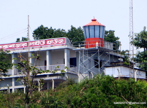
Date unknown. Inactive at least since 2023. Approx. 10 m (33 ft) structure, a short square skeletal tower with lantern and gallery adjacent to a 2-story concrete building. Lantern painted orange. A photo by Shameem Bakhshi is at right, I.H. Chowdhury has a closeup photo, Indranil Kishor has a closeup of the lantern, and Google has a satellite view. The light may be, or may have been, moved atop a tall tower seen next to the historic lighthouse in the satellite view. Iftekharul Islam has a 2022 photo of a modern dwelling for the keepers of the lighthouse. More information is needed on this station and its history. Cox's Bazar is a fishing port, tourism center, and (as its name implies) a market town with a population of about 250,000. Located on the highest point of a ridge in Cox's Bazar about 1 km (0.6 mi) from the beach. Site appears open, tower closed.

Cox's Bazar Light, Cox's Bazar, May 2014
ex-Panoramio Creative Commons photo by Shameem Bakhshi
* Cox's Bazar (2)
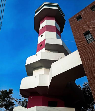
Date unknown (2023?). Active; focal plane Active; focal plane 74 m (243 ft); white flash every 15 s. 34 m (112 ft) octagonal concrete tower with lantern and gallery, painted with red and white horizontal bands. The tower is connected by an overhead walkway to a 3-story building. Shahadat Hossain's 2024 photo is at right, a 2023 photo is available, M.D. Azhar has a photo of the light in action, Farzana Sharmin has a distant view showing the new light and (zoom in) the old one, and Google has a satellite view. Located adjacent t the historic lighthouse, which had a focal plane of only 54 m (177 ft). Site appears open, tower closed. Operator: Bangladesh Department of Shipping. ARLHS BAN-001; Admiralty F1056.4; NGA 26756.
* Kutubdia (Akbar Char, Kutubdia Island) (2)
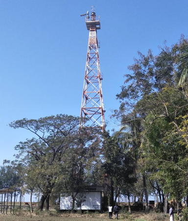
Date unknown (2004?) (station established 1846). Active; focal plane 39 m (128 ft); three white flashes every 10 s. Approx. 35 m (115 ft) square pyramidal skeletal tower with lantern and gallery. The top of the tower carries a red and white horizontally slatted daymark. Arman Sunderban's photo at right, published by a local newspaper, is now available from Lightphotos.net. Sadikur Rahman has a 2018 photo (also seen below right), Sujan Chowdhury has a closeup, Alik Barua has a 2021 photo, and Google has a satellite view. The lighthouse appears to be a twin of the St. Martin's Island lighthouse. The Admiralty first listed it in a Notice to Mariners in February 2005. The original masonry lighthouse had a height of about 34 m (111 ft) and a focal plane of 37 m (121 ft). It has gone to sea due to beach erosion, and some sources report that a portion of it remains visible at low tide. Kutubdia is an island about 30 km (19 mi) long, located just off the coast about 50 km (30 mi) south of Chittagong. It is fairly densely populated, with a permanent population of about 90,000. The lighthouse is located on the northwestern coast of the island. Site probably open, tower closed. Operator: Bangladesh Department of Shipping. ARLHS BAN-004; Admiralty F1054; NGA 26760.

Chittagong District Lighthouses
* Norman's Point (Chittagong River) (4?)
Date unknown (around 2006?) (station established 1866). Active; focal plane 45 m (148 ft); one long white flash every 10 s. Approx. 35 m (115 ft) square pyramidal skeletal tower painted with red and white horizontal bands. Md Sahidul Islam Sujan has a 2022 photo, Mohammed Istiar has another 2022 photo, and Google has a satellite view. The Chittagong Port Authority refers to the lighthouse as "new" and reports it has a range of 17 nautical miles, the same as the St.Martin's Island and Kutubdia lighthouses. NGA lists a much smaller tower with a focal plane of 12 m (39 ft) and a range of 12 nautical miles. This is consistent with descriptions around 1900 of a small brick tower on the point, but a 1920 light list gives a focal plane height of 18 m (55 ft). According to Findlay's 1879 list, the original light here was a "white beacon," and a second beacon was built 40 yards (37 m) to the west in 1878. These lights were intended to mark the best area for ships to anchor offshore. Located about 2 km (1.2 mi) south southeast of the point, the south side of the entrance to the Karnaphuli estuary and Chittagong harbor, the country's principal deepwater port. Operator: Chittagong Port Authority. Site probably open, tower closed. ARLHS BAN-005; Admiralty F1048; NGA 26764.

Cox's Bazar Light, Cox's Bazar, January 2024
Google Maps photo by Shahadat Hossain
 
Chittagong Inner Bar Range Front (2)
Date unknown. Active; focal plane about 25 m (82 ft); quick-flashing white light. Approx. 25 m (82 ft) square pyramidal skeletal tower painted with red and white horizontal bands. A 2020 photo is available, Mitul Chowdhury has a photo showing both range lights, and Google has a satellite view. This is a second range guiding vessels in the Karnaphuli River, Chittagong's harbor. Note: photos show all of the river's range lights to be taller than described in the light lists. Located next a warehouse on the east side of the river. Site status unknown. Operator: Chittagong Port Authority. Admiralty F1051; NGA 26784.
Chittagong Inner Bar Range Rear (2)
Date unknown. Active; focal plane about 45 m (148 ft); quick-flashing white light. Approx. 25 m (82 ft) square pyramidal skeletal tower. painted with red and white horizontal bands. Evan Habib has a 2021 closeup photo, Mitul Chowdhury has a photo showing both range lights, and Google has a satellite view. Located on a hillside about 390 m (1/4 mi) northeast of the front light. Site status unknown. Operator: Chittagong Port Authority. Admiralty F1051.1; NGA 26788.
Gupta Crossing Outbound Range Front (2)
Date unknown. Active; focal plane about 25 m (82 ft); quick-flashing white light. Approx. 25 m (82 ft) square pyramidal skeletal tower painted with red and white horizontal bands. A distant Google street view is available, Yesmin Ara Begum has a view across the river in which all four Gupta Crossing Range Lights can be distinguished; the outbound lights are on the right. Google has a satellite view. Located on the east side of the river near a sharp bend in downtown Chittagong. Site status unknown. Admiralty F1053.4; NGA 26820.
Gupta Crossing Outbound Range Rear (2)
Date unknown. Active; focal plane 45 m (148 ft); quick-flashing white light. Approx. 25 m (82 ft) square skeletal tower painted with red and white horizontal bands. Google has a street view and a satellite view. Located 190 m (625 ft) east southeast of the front light. Site status unknown. Operator: Chittagong Port Authority. Admiralty F1053.41; NGA 26824.
 

Kutubdia Light, Kutubdia Island, January 2018
Google Maps photo by Sadikur Rahman
 
Gupta Crossing Inbound Range Front (2)
Date unknown. Active; focal plane about 25 m (82 ft); quick-flashing white light. Approx. 25 m (82 ft) square pyramidal skeletal tower painted with red and white horizontal bands. Yesmin Ara Begum has a view across the river in which all four Gupta Crossing Range Lights can be distinguished; the inbound lights are on the left. Google has a satellite view. This is the third range for vessels entering Chittagong. Located just offshore on the east side of the river at a sharp bend in downtown Chittagong. Site open, tower closed. Admiralty F1052; NGA 26804.
Gupta Crossing Inbound Range Rear (2)
Date unknown. Active; focal plane 45 m (148 ft); quick-flashing white light. Approx. 25 m (82 ft) square skeletal tower painted with red and white horizontal bands. No closeup photo available but Google has a satellite view. Located 150 m (490 ft) northeast of the front light. Site status unknown. Operator: Chittagong Port Authority. Admiralty F1052.1; NGA 26808.
Custom Mark Range Front
Date unknown. Inactive since 2016. Approx. 25 m (82 ft) square pyramidal skeletal tower painted with red and white horizontal bands and carrying a radar antenna. Nazim Khan has a 2022 photo and Google has a street view and a satellite view. Located on the waterfront of downtown Chittagong, near the bend in Strand Road. Site status unknown but the tower is easy to see from nearby streets. ex-Admiralty F1053.8; NGA 26826.
* P.K. Sen Bhaban (Custom Mark Range Rear)
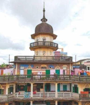
Around 1920. Inactive since 2016. The light was mounted on the dome of a large building. A bhaban or bhavan is a large formal building such as a palace, mansion, or house of parliament; this one was built by P.K. Sen, a wealthy merchant and civic leader. Sazid Mahmud has a 2018 photo, Avoy Pal has a closeup of the dome (also seen at right), and Google has a street view and a satellite view. The building is considered historic but is in very poor condition; there are efforts to preserve it. Located several blocks from the waterfront in downtown Chittagong. Site open, building closed. ex-Admiralty F1053.81; NGA 26826.1.
* Chittagong Outer Bar Range Front
Date unknown. Active; focal plane 14 m (46 ft); quick-flashing red light. 13 m (43 ft) square skeletal tower painted with red (formerly black) and white horizontal bands. Google has a street view and a satellite view. Located on the waterfront on the west side of the river entrance about 400 m (1/4 mi) northeast of the Patenga lighthouse. Site open, tower closed. Operator: Chittagong Port Authority. Admiralty F1050.4; NGA 26776.

P.K. Sen Bhaban, Chittagong, June 2010
Google Maps photo by Avoy Pal
* Chittagong Outer Bar Range Rear (2?)
Date unknown. Active; focal plane 20 m (66 ft); quick-flashing red light. 17 m (56 ft) square skeletal tower painted with red (formerly black) and white horizontal bands. This light was relocated 200 m (1/8 mi) southwest in 20023 because a new building was blocking the view of the origianl light. Google has a satellite view. Located on the waterfront about 350 m (1/4 mi) northeast of the front light. Site open, tower closed. Operator: Chittagong Port Authority. Admiralty F1050.41; NGA 26780.
* Patenga
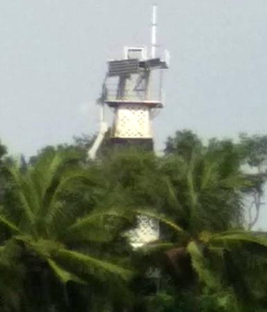
Date unknown. Active; focal plane 20 m (66 ft); red flash every 10 s. 24 m (79 ft) square pyramidal metal tower, painted with black and white horizontal bands. A photo is at right, Badre Alam Siddiqui has a 2018 photo, and Google has an indistinct satellite view of the lighthouse poking through trees. Patenga is on the point of land at the west side of the entrance to the Karnaphuli estuary and Chittagong harbor. Located on Patenga Point, on the grounds of the Bangladeshi Naval Academy. Site open, tower closed. Operator: Chittagong Port Authority. Admiralty F1049; NGA 26792.
Patenga Point Entrance (2?)
Date unknown. The original light was removed in 2020 or 2021; it was an approx. 15 m (49 ft) robust post with a small gallery, painted with red and white horizontal bands. Badre Alam Siddiqui has a 2018 photo. The light stood off the end of the often-submerged north breakwater extending from Patenga Point. In 2020 or 2021 a new light was place on the breakwater about 300 m (1/5 mi) to the northeast. Bing has a satellite view. This light is not listed by the Admiralty. Located off Patenga Point marking the port (left) side of the entrance to Chittagong. Accessible only by boat but previously visible from the point. Site open, tower closed. ex-Admiralty F1048.2.
Bhasan Char Southeast
2019. Active; focal plane unknown; continuous white light. An Indian Notice to Mariners describes this only as a flood warning monioring station. No photo available and the light is not shown in Bing's satellite view. Located about 3 km (2 mi) southeast of the southern tip of Bhasan Char, an island off the mouth of the Meghna River, the easternmost and widest mouth of the Ganges. Accessible only by boat. Site status unknown. Operator: unknown. Admiralty F1047.7.
Bhasan Char
2018. Active; focal plane 25 m (82 ft); two white flashes every 10 s. Approx. 25 m (82 ft) octagonal tower with an open lantern and gallery. Tower painted with gray and white horizontal bands; lantern painted red. Zzoha Tasdiquzzoha has a 2019 photo (also seen below right), a 2023 photo is available, Zzoha Tasdiquzzoha has a 2019 photo, and Google has a satellite view. The lighthouse is called the Beacon of Hope. Located on the west shore of Bhasan Char. Accessible only by boat. Site ope, tower status unknown. Operator: unknown. Admiralty F1047.5.

Patenga Light, Chittagong, October 2008
ex-Panoramio photo by Dhakaiya now on Lightphotos.net

Khulna Division Lighthouses

Mongla Approach Lighthouses
The Port of Mongla is about 130 km (81 mi) upstream from the Bay of Bengal on the Pusur (or Pusser) River, one of the many mouths of the Ganges. The modern port was established in 1954 to provide a port of entry for southwestern Bangladesh (then East Bengal).

#Jefford Point (1)
Date unknown. Inactive since 2011 and demolished soon after. This was a 36 m (118 ft) square skeletal tower. No photo available and the tower is not seen in Google's satellite view. Jefford Point is named for Admiral James Jefford, a Royal Navy officer who served as Pakistan's first naval chief of staff. Formerly located on the east side of the entrance to the Pusur River. Accessible only by boat. Site status unknown. ARLHS BAN-003; ex-Admiralty F1045; ex-NGA 26836.
Jefford Point (2) (Dublar Char)
2015. Active; focal plane 40 m (131 ft) ; two white flashes every 10 s. Approx. 35 m (115 ft) square skeletal communications tower painted white. A closeup 2022 photo is available and Google has a street view and a satellite view. The light is on the grounds of a seafood processing center being developed on Dublar Char island. Located on the east side of the entrance to the Pusur River about 3 km (2 mi) north of the original light. Site status unknown. Admiralty F1046.
Hiron Point
Date unknown. Active; focal plane 36 m (118 ft) ; two white flashes every 10 s. 35 m (115 ft) square skeletal tower. The tower stands next to the Hiron Point Pilot Station. Naeem Hossain has a 2022 photo and Google has an indistinct satellite view. Located on the west side of the entrance to the Pusur River. Accessible only by boat. Site status unknown. ARLHS BAN-002; Admiralty F1045.5; NGA 26840.
Akram Point
Date unknown. Active; focal plane about 20 m (66 ft); light characteristic unknown. Approx. 20 m (66 ft) tower. No photo available but Google has a distant satellite view. Located at the southern tip of an island dividing two branches of the river. Site status unknown. Admiralty F1044.8.

Bhasan Char Light, Bhasan Char, March 2019
Google Maps photo by Zzoha Tasdiquzzoha
Hamid Point
Date unknown. Active; focal plane about 23 m (75 ft); light characteristic unknown. Approx. 20 m (66 ft) tower. No photo available but Google has an indistinct satellite view and a street view through the forest. Located on the west side of the eastern branch of the river about 25 km (15 mi) north of Akram Point. Site status unknown. Admiralty F1044.3.
Base Creek
Date unknown. Active; focal plane about 23 m (75 ft); light characteristic unknown. Approx. 20 m (66 ft) tower painted with red and white (or black and white) horizontal bands. No photo available but Google has a distant satellite view. Located on the east side of the river at an area where dredge spoil is deposited. Site status unknown. Admiralty F1044.2.
Karamjal (Koromjal)
Date unknown. Active; focal plane about 23 m (75 ft); light characteristic unknown. Approx. 20 m (66 ft) tower painted with red and white horizontal bands. A 2016 Google sea view shows the tower with no lens (perhaps not yet complete). Google also has a distant satellite view. Located on the west side of the river about 10 km (6 mi) south of the Mongla port facilities. Site status unknown. Admiralty F1044.1.

Information available on lost lighthouses:

Notable faux lighthouses:

Adjoining pages: South: Myanmar (Burma) | West: West Bengal and Odisha

Return to the Lighthouse Directory index | Ratings key

Posted November 18, 2007. Checked and revised June 18, 2024. Lighthouses: 25. Site copyright 2024 Russ Rowlett and the University of North Carolina at Chapel Hill.