Lighthouses of Myanmar (Burma)

The Republic of the Union of Myanmar occupies the northeast coast of the Bay of Bengal, between Bangladesh to the northwest and Thailand to the southeast. The country also includes a long southern extension along the coast of the Andaman Sea, the eastern basin of the Bay of Bengal separated from the rest of the bay by the Andaman and Nicobar Islands of India. The country's major port is Yangon (formerly called Rangoon), located on the Yangon River about 30 km (19 mi) from the sea.

Burma, as the country was called for many years, became a British colony as a result of a series of colonial campaigns between 1826 and 1886. Governed until 1937 as a part of the British Empire of India, the country became independent in 1948. A military junta took control in 1988 and changed the country's name to Myanmar. Civil unrest and international sanctions have made the nation unattractive or dangerous for foreign tourists; as a result we know little of the status of the lighthouses built in British Burma. (It doesn't help that none of the historic lighthouses are accessible without boat transportation.) Current information and photos are badly needed.

Myanmar is divided into seven regions, mostly inhabited by the dominant Bamar population, and seven states, mostly inhabited by ethnic minorities.

The Myanmar (Burmese) word for a lighthouse is meepyatite (မီးပြတိုက်). An island is kyun, myit is a river, and siutkam is a port or harbor.

Aids to navigation in Myanmar are maintained by the Myanma Port Authority (MPA), an agency of the Ministry of Transport.

ARLHS numbers are from the ARLHS World List of Lights. Admiralty numbers are from volume F of the Admiralty List of Lights & Fog Signals. U.S. NGA List numbers are from Publication 112.

General Sources
Leuchttürme in Myanmar
Photos taken in January 2011 and November 2014 by Andreas Köhler.
World of Lighthouses - Myanmar
Photos by various photographers available from Lightphotos.net.
Online List of Lights - Burma
Photos by various photographers posted by Alexander Trabas.
Lighthouses of Other Regions
Historic postcard views posted by Michel Forand.
Leuchttürme Asiens, Australiens, und Ozeaniens auf historischen Postkarten
Historic postcard views posted by Klaus Huelse.
Navionics Charts
Navigation chart for Myanmar.

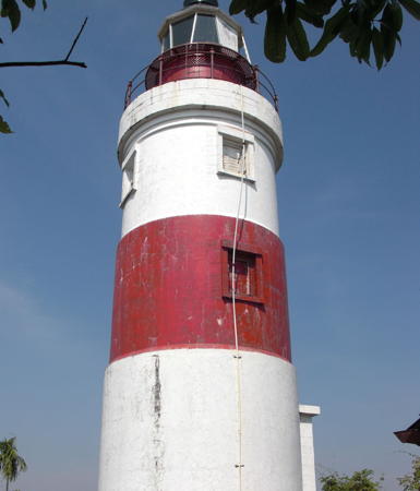
Green Island Light
Green Island Light, Kyaikkami, January 2011
photo copyright Andreas Köhler; used by permission
Coco Islands Lighthouse
Table Island (Mingala Kyun, Coco Islands)
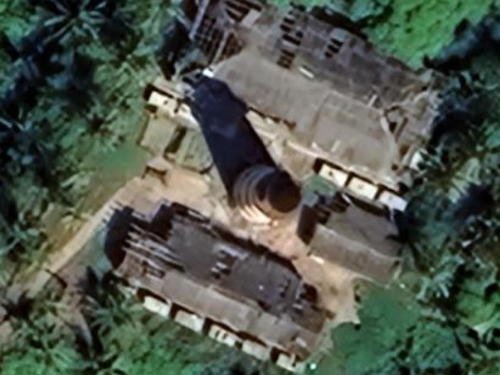
1867. Active (?); focal plane 59 m (194 ft); four white flashes every 25 s. 27 m (92 ft) cast iron tower with lantern and gallery, painted with red and white horizontal bands. Two 1-story brick keeper's houses and other light station buildings. No recent photo available but Huelse has a historic photo; Google has a satellite view and part of an older Google satellite view is seen at right. There is no sign that the station is occupied. The Coco Islands are an extension northward of the Andaman Islands administered by India; British colonial authorities transferred them to Burma in 1882. In 1953 India sought to lease the light station in order to better protect shipping in the Bay of Bengal but Burma rejected this proposal. The islands are uninhabited but the Burmese Navy maintains a small base on Great Coco Island. According to various sources China has leased facilities on the islands, but the government of Myanmar denies this and there is no credible evidence of significant military activity in the islands. More recently the government has announced interest in developing tourism in the islands, which are an important nesting site for marine turtles. The islands are attached administratively to the Yangon Region. Located on Table Island, the northernmost of the islands, about 3 km (2 mi) north of Great Coco Island and 250 km (150 mi) south southwest of the Irrawaddy Delta on the mainland. Accessible only by boat. Site status unknown but almost certainly closed to casual visitors. ARLHS MYA-018; Admiralty F1200; NGA 26564.

Table Island Light, Bay of Bengal, 2022
satellite view copyright Google Maps


Tanintharyi Region (Southern Burma) Lighthouses
Pak Chan River (Pulau Perlin, Myin Sei Kyun)
Date unknown (station established 1893). Active; focal plane 16 m (52 ft); white flash every 5 s. 16 m (52 ft) square skeletal tower. No photo available but Bing has a satellite view. This light marks the northern entrance to the Pak Chan estuary, which forms the border between Thailand and Myanmar. Note: NGA misspells the name as Pulau Palin. Located at the southeastern tip of Myin Sei Kyun (Pulau Perlin), an island about 10 km (6 mi) west of Kawthaung, the southernmost town in Myanmar. Accessible only by boat. Site status unknown. Admiralty F1158; NGA 26570.
* Seikkantha (Myeik, Mergui Harbour)
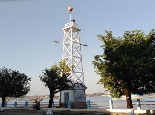
Date unknown. Active; focal plane 15 m (49 ft); quick-flashing white light. 19 m (62 ft) square wood skeletal tower rising from a 1-story wood equipment shelter. Lighthouse painted white. Mehn Phyo has the closeup 2019 photo seen at right and Google has a satellite view. Myeik (formerly Mergui) is the largest port in southern Myanmar; it was formerly a Thai outpost but it was conquered by Burmese in 1765 and the British annexed it to Burma in 1826. Located at the water's edge on the Myeik waterfront. Site open, tower closed. Admiralty F1144; NGA 26576.
Kalwin Point
Date unknown. Active (?); listed with focal plane 12.5 m (41 ft); white flash every 3 s. 12.5 m (41 ft) square pagoda-style building topped by a short mast and mounted on a square concrete pier. No photo available but Google has a satellite view. With no solar panels in sight it seems unlikely that this interesting building is an active lighthouse. Located off a swampy point at the entrance to Myeik, about 10 km (6 mi) north of city's waterfront. Accessible only by boat. Site open, tower closed. Admiralty F1138; NGA 26572.
Mali Kyun (Cornwall Point, Tavoy Island)
Date unknown. Active (?); listed with focal plane 6 m (20 ft); white flash every 5 s. 4 m (13 ft) square skeletal tower painted in a black and white checkered pattern. No photo available but Bing has a satellite view. Mali Kyun (Tavoy Island) is a long island at the northern end of the Mergui Archipelago. Located at the easternmost point of the island. Accessible only by boat. Site status unknown. Admiralty F1136; NGA 26580.
 

Seikkantha Light, Myeik, November 2019
Google Maps photo by Mehn Phyo
Mibya Kyun (Reef Island, Tavoy River)
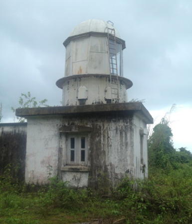
1883. Clearly inactive; listed with focal plane 94 m (308 ft); white flash every 5 s. 9 m (30 ft) square masonry tower with a "round lantern," according to NGA. Lighthouse painted white. Sangamithra Iyer's photo is at right and Google has a satellite view. Endangered; the lighthouse is abandoned and deteriorating. Located in southern Myanmar on the west side of the entrance to the Tavoy estuary. Accessible only by boat. Site status unknown. ARLHS MYA-009; Admiralty F1132; NGA 26584.
Kyaukpyn Kyun
Date unknown. Clearly inactive; listed with focal plane 53 m (174 ft); white flash every 7 s. 4 m (13 ft) "black and white checkered framework tower," according to the NGA List. No photo available; Earlier versions of Google's satellite view appeared to show a small square pyramidal tower, but the tower, if it is standing, has disappeared into the forest. Located on a tiny island off the southern end of Auk Bok, the southermost of the Moscos Islands. Accessible only by boat. Site status unknown. Admiralty F1131; NGA 26588.

Mon State Lighthouses
Kyun Nyi Naung (Double Island)
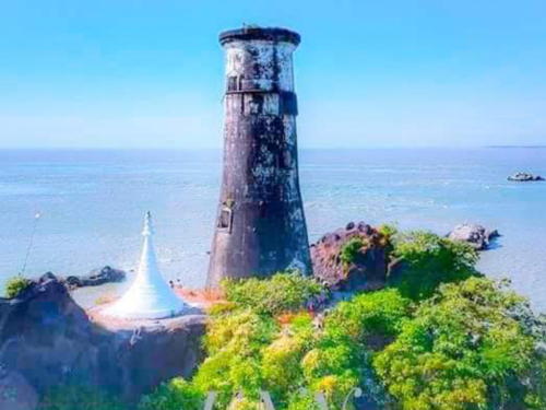
1865. Clearly inactive; listed with focal plane 43 m (141 ft); white flash every 15 s. 20 m (66 ft) brick tower with lantern and gallery, mounted on a granite base. Lighthouse painted white. Sa Lu has a closeup 2021 photo (also available here), Huelse has a historic photo, and Google has a satellite view. Endangered; the lighthouse is abandoned and deteriorating. The British engineers shipped brick from Singapore for this lighthouse, which guided ships toward the Moulmein River entrance to the north. Located on a small island about 11 km (7 mi) offshore and about 25 km (15 mi) south of Kyaikkami, on the approach to the Irrawaddy from the south. Accessible only by boat. Site status unknown. ARLHS MYA-004; Admiralty F1128; NGA 26592.
Green Island (Amherst Point)
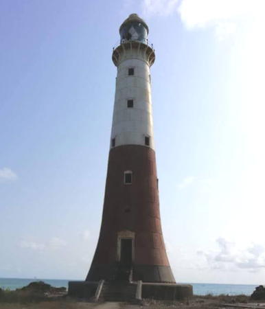
1903. Active; focal plane 41 m (135 ft); two white flashes every 10 s. 20 m (66 ft) masonry tower, painted with red and white horizontal bands. 1-story keeper's house and other light station buildings. A photo by Köhler is at the top of this page, Trabas also has Köhler's photo, Huelse has a historic photo, and Google has a satellite view. Köhler visited the station in January 2011 and found it in good condition and staffed by a team of keepers. The lighthouse marks the entrance to the Moulmein River from the Gulf of Martaban. Located on a small island close to shore at Kyaikkami, a temple and resort town known as Amherst during the colonial period. Accessible only by boat. Site open, tower open by arrangement with the keepers. ARLHS MYA-006; Admiralty F1126; NGA 26596.
Tavoy River Light
Mibya Khun Light, Tavoy River, June 2013
photo copyright Sangamithra Iyer; used by permission

Yangon (Rangoon) Region Lighthouses
Eastern Grove Flats (Thante Point)
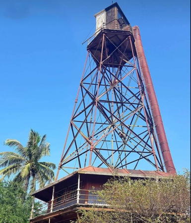
1869. Active (?); focal plane 28 m (92 ft); white light, 4 s on, 2 s off. 32 m (105 ft) cast iron skeletal tower with lantern and gallery, mounted on a screwpile foundation; a 1-story keeper's house is included in the lower portion of the tower. The lighthouse was originally painted red and the lantern black and white. Yan Naung's 2022 photo is at right. The lighthouse appeared abandoned in earlier photos, but in recent years it has been renovated and perhaps reactivated. Aung Yethu has a 2020 photo and Google has an indistinct satellite view. Navionics charts the light as active. Located on the east side of the entrance to the Yangon River estuary leading to Yangon (Rangoon), the capital of the country. Accessible by 4WD during the dry season. Site open, tower closed. ARLHS MYA-005; Admiralty F1088; NGA 26620.
#Thilawa Range Common Rear
Date unknown. Removed in 2020. This was a 16 m (53 ft) square skeletal tower with gallery. No photo available. This light was the rear light for both an upstream and a downstream range on the Yangon River. Google has a satellite view of the location. Located in the Thilawa oil terminal on the east side of the estuary about 20 km (13 mi) south of Yangon city. Site status unknown. ex-Admiralty F1101; NGA 26644.
[Thanlyin Point Range Rear]
Date unknown. Active; focal plane about 20 m (66 ft); white flash every 2 s. Approx. 18 m (59 ft) mast with gallery. No photo available but Google has a satellite view. The purpose of this range is not clear. The front light is on a similar mast. Located on a marshy point on the east side of the estuary opposite the city. Accessible by road. Site probably open, tower closed. Admiralty F1104.52.
Thanlyetsoon (Monkey) Point
Date unknown (station established 1894). Active; focal plane 9 m (30 ft); continuous white, red or green light depending on direction. 9 m (30 ft) round white metal tower. No photo available but Google has an indistinct satellite view. Located on the point marking the north side of the entrance to the Yangon harbor area. Site status unknown. Admiralty F1105.
Seik Giy Training Wall East End
Date unknown. Active; focal plane about 8 m (26 ft); white flash every 5 s. 4 m (13 ft) mast on a round concrete tower, painted with red and white horizontal bands. Lightphotos.net has a photo, Panchan Kyaik has a view, and Google has a satellite view. Located at the end of breakwater across the river from downtown Yangon. Site status unknown. Admiralty F1105.5.

Eastern Grove Flats Light, October 2022
Google Maps photo by Yan Naung
#Yangon (Rangoon) Lightships
There is a photo of two lightships, taken in November 2010 (2/3 the way down a long page of photos); one of these vessels is marked for the Thuriya station (ARLHS MYA-020) southwest of Alguada Reef and the other is marked for the Dagon station (ARLHS MYA-003) on the approaches to Yangon. Lei Mon has a February 2019 photo of these two lightships joined by a third lightship at the Thamada Ferry Jetty opposite downtown Yangon. In 2021 the ships were removed and probably scrapped. They are missing in Google's latest satellite view. Information on all these vessels is needed. Lightphotos.net has Jaap Termes's historic photo of two other lightships, identified as the Krishna and the Baragua.

Ayeyarwady Region Lighthouses
Alguada Reef
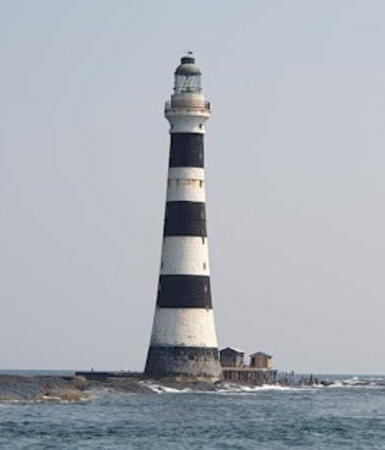
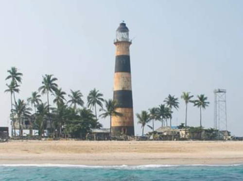
1865. Active; focal plane 44 m (144 ft); white flash every 10 s. 49 m (161 ft) tapered granite tower with lantern and gallery, painted with black and white horizontal bands. Keeper's house and other station buildings connected to the lighthouse by a raised walkway. Part of Mya Min Din's 2020 photo is at right, a second photo shows the keeper's cottage, Huelse has a historic photo, Michel Forand has posted an 1865 drawing of the lighthouse, and Bing has a good satellite view. Surely one of the most impressive lighthouses ever built in Britain's empire, this tower was based on Alan Stevenson's design for the Skerryvore lighthouse in Scotland. It took six years to build, since construction was only possible during the winter monsoon. The lighthouse was strafed by U.S. aircraft in March 1943. Located at the end of a long reef in the Bay of Bengal extending from Cape Negrais, the southwestern tip of Myanmar. Accessible only by boat. Site and tower closed. ARLHS MYA-001; Admiralty F1068; NGA 26688.
Thamihla Kyun (Thamhee Hla, Diamond Island)
Date unknown (station established 1913). Active; focal plane 24 m (79 ft); white flash every 4 s. 12 m (39 ft) skeletal tower, painted with red and white horizontal bands. No photo available but Google has an indistinct satellite view. Diamond Island is famous as a nesting place for green and loggerhead turtles. Located on an island off Cape Negrais, marking the entrance to the Bassein River. Accessible only by boat. Site and tower closed. Admiralty F1070; NGA 26692.
Goyangyi Kyun (?)
Date unknown. Active; focal plane 66 m (217 ft); white flash every 15 s. Skeletal tower, painted with black and white horizontal bands. No photo available and the light has not been found in Google's satellite view. NGA misspells the name as Gorangyi Kyun. Goyangyi Kyun is a steep ridge connected to the mainland by a narrow isthmus about 65 km (40 mi) north of Cape Negrais. The ridge is crowned by the Myawaddy Pagoda. Linn Yan Kha's street view from the pagoda does not show a light, casting doubt on its existence. Site status unknown. Admiralty F1067; NGA 26704.

Rakhine State Lighthouses
Nantha Kyun
Date unknown. Active; focal plane 169 m (554 ft); quick-flashing white light. Described as a 3 m (10 ft) black and white checkered tower. It seems almost certain that this tower is actually mounted atop a building. No photo available but Bing has a satellite view of a station, the only structures seen on the island. Nantha Kyun is a mud volcano centered on a small island about 30 km (19 mi) off the south coast of Rakhine state. Located near the summit of the island. Site status unknown. Admiralty F1066; NGA 26712.

Alguada Reef Light, Bay of Bengal, February 2020
Google Maps photo by Mya Min Din
Lontha (Andrew Bay)
Date unknown. Active; focal plane 41 m (131 ft); white flash every 8 s. 11 m (36 ft) square skeletal tower. NGA descibes the tower as "black and white checkered" but it appears all white in a 2018 street view by Kyaw Myo Naung. Google has an indistinct satellite view. Located on a promontory at Gyeiktaw. Site status unknown. Admiralty F1065; NGA 26708.
Zalat Taung (Singaung) (1?)
Date unknown. Inactive. Approx. 9 m (30 ft) square white skeletal tower with an enclosed base. Pai Soe has a 2021 photo but the light is not seen in Google's fuzzy satellite view. The Admiralty locates a light farther east on this island, but no tower has been found there. Located at the northwestern end of Zalat Taung Island, on the south side of the entrance to the Sandoway River estuary. Site open, tower closed. Admiralty F1064.8(?).
Ohntapin Kyun (Unguan Island)
Date unknown. Active; focal plane 44 m (141 ft); white flash every 12 s. 5 m (17 ft) (?) black and white checkered tower (NGA's description). No photo available but Bing has an indistinct satellite view. A taller tower is needed here to clear the trees. Located on a small and isolated island about 30 km (19 mi) southeast of Cheduba Island. Accessible only by boat. Site status unknown. Admiralty F1064.5; NGA 26716.
Ohnchaung Range Front
Date unknown (recent). Active; focal plane about 10 m (33 ft), light characteristic unknown. Approx. 10 m (33 ft) white skeletal tower. No photo available but Google has a satellite view. Located at the north side of the entrance to Ohnchaung near the northeast point of Cheduba Island. Site open, tower closed. Admiralty F1064.2.
 
Ohnchaung Range Rear
Date unknown (recent). Active; focal plane about 12 m (39 ft), light characteristic unknown. Approx. 12 m (39 ft) white skeletal tower. No photo available but Google has a satellite view. Located about about 150 m (500 ft) west of the front light. Site open, tower closed. Admiralty F1064.21.
Mun Aung (Beacon Island)
1909. Active; focal plane 37 m (121 ft); white flash every 5 s. 36 m (118 ft) round cast iron tower with lantern and gallery. The lower half of the lighthouse is painted red and the upper half white. Arezarni Kyawzaya's 2021 photo is at right, he also hasa view from the sea, MPA has a photo, and Bing has a satellite view. Located on a small island about 8 km (5 mi) northwest of the northwestern point of Cheduba Island and roughly 150 km (90 mi) south of Sittwe. Accessible only by boat. Site status unknown. ARLHS MYA-010; Admiralty F1064; NGA 26724.

Mun Aung (Beacon Island) Light, Bay of Bengal, May 2021
Google Maps photo by Arezarni Kyawzaya
Thanta (North Terrible Rock)
Date unknown. Active; focal plane 16.5 m (54 ft); white flash every 8 s. 14 m (46 ft) square skeletal tower, painted with black and white horizontal bands. No photo available but Google has a fuzzy satellite view. Located on an isolated rock off Kyaukpyu, about 80 km (50 mi) southeast of Sittwe. Accessible only by boat. Site and tower closed. Admiralty F1061; NGA 26728.
Paungnetkyi (Laws Island)
Date unknown. Active (?); focal plane 33 m (108 ft); white flash every 5 s. 12 m (39 ft) square skeletal tower, lower half painted red and upper half white. Arakan Indobhasa has a closeup 2018 photo and Google has a distant satellite view. The lighthouse appears to be abandoned. Located on the west side of the island, opposite the waterfront of Kyaukpyu, a district capital south of Sittwe. Accessible only by boat. Site and tower closed. Admiralty F1062; NGA 26732.
Savage Island (Laychindaung, Great Savage Island, Aracan) (2)
1891 (station established 1844). Inactive, apparently since the 1980s. 21 m (69 ft) round stone tower; lantern removed. A 2021 photo is at right, Chandrasekhar Chatterjee has a 2017 photo, Albert U Htin has a 2021 closeup, a 2009 photo is available, Köhler has a photo, Christoph Ulleweit has a fuzzy view from the sea, Huelse has a historic postcard view, and Google has a satellite view. Forand has a historic postcard view of Myanmar's first lighthouse (called Fakir Point), built here in 1844 by Lieutenant Siddons of the Royal Engineers. The abandoned lighthouse is clearly endangered. The lighthouse was probably deactivated in favor of the Sittwe light (next listing). Located on a small island off the south side of the entrance to Sittwe (formerly Aracan). Accessible only by boat. Site status unknown. ARLHS MYA-022; ex-Admiralty F1060.
 

Savage Island Light, Sittwe, August 2021
Google Maps photo by Mg Chay
 
** Sittwe (Fakir Point) (1)
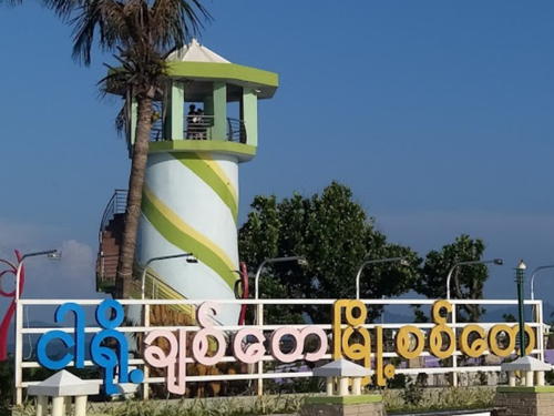
Date unknown. Inactive. Approx. 7 m (23 ft) round concrete tower, originally painted with narrow black and white horizontal bands but painted with spiral bands of various colors in recent years. A stairway winds around the tower, and the lantern has been replaced by a covered observation deck. Kaung San's October 2023 photo is at right, Mi Mi Zin Phyoe has a May 2023 photo showing a different paint scheme, Köhler has a 2014 photo, Lightphotos.net has Köhler's photo, Myozin Oo has a photo of both Sittwe lighthouses, Emika Young has a 2016 street view, Huelse has a historic postcard view, and Google has a satellite view. The lighthouse is located in a popular public park known as Sittwe Viewpoint. Sittwe (Fakir) Point must have been inundated by the storm surge of Tropical Cyclone Mocha when it struck Sittwe on 14 May 2023 but the satellite view shows that the lighthouses survived. Located about 80 m (260 ft) north of the active light (next entry). Site open, and visitors can climb the stairway to the gallery.
* Sittwe (Fakir Point) (2)
Date unknown. Active; focal plane 27 m (89 ft); white flash every 10 s. 27 m (89 ft) square pyramidal skeletal tower with gallery and a small lantern, painted white. Köhler has a 2014 photo, Trabas has Köhler's photo, Arezarni Kyawzaya has a 2017 photo, Lightphotos.net has a fine closeup photo, Emika Young has a 2016 street view, Myozin Oo has a 2015 photo of both lighthouses in which the old lighthouse is painted white, Forand has a historic postcard view of both lighthouses, and Google has a satellite view. Located on a sharp point on the north side of the entrance to Sittwe. Site status unknown. ARLHS MYA-017; Admiralty F1059; NGA 26744.

Original Sittwe Light, Sittwe, October 2023
Google Maps photo by Kaung San
Mayu (Oyster Island) (2)
1892 (station established 1885). Active (?); focal plane 40 m (131 ft); white or red light, depending on direction, 10 s on, 5 s off. 43 m (141 ft) round cast iron tower with lantern and gallery (originally, at least). Lighthouse painted with blue and white horizontal bands. Thiha Paing has the photo at right and a closeup of the top of the tower, Huelse has a historic photo and Bing has a satellite view of the station. The lighthouse was repaired after being damaged by Cyclone Mala in 2006. It is endangered by rising sea level and in 2018 MPA announced plans to protect it with a seawall. The Burmese Navy staffed this station until 2009. The light may then have been moved to the square skeletal tower seen in the photo at right. Located about 25 km (15 mi) southwest of Magyichaung in westernmost Myanmar. Accessible only by boat. Site and tower closed. ARLHS MYA-012; Admiralty F1058; NGA 26748.

Information available on lost lighthouses:

  • China Bakir (1869-1920s), off the Irrawaddy Delta. This screwpile lighthouse was rebuilt in 1901. It was still in service in 1920 but was replaced soon thereafter by a lightship. Ruins were visible for many years.
  • Krishna Shoal (1869-1877), off the Irrawaddy Delta. This screwpile lighthouse was destroyed, probably by a tropical cyclone. The lighthouse was replaced by the lightship Krishna; Jaap Termes has a historic photo of a more recent lightship at the station. Currently the Sanda lightship station is near this location. Admiralty F1074; NGA 26680.
  • Oyster Reef (1876-1884). Destroyed by a tropical cyclone, this screwpile light was replaced by the Oyster Island lighthouse.

Notable faux lighthouses:


Mayu (Oyster Island) Light, Bay of Bengal, September 2019
Google Maps photo by Thiha Paing

Adjoining pages: North: Bangladesh | Southeast: Southern Thailand: West Coast | South: Andaman and Nicobar Islands

Return to the Lighthouse Directory index | Ratings key

Posted February 20, 2006. Checked and revised June 11, 2024. Lighthouses: 31; lightships: 2. Site copyright 2024 Russ Rowlett and the University of North Carolina at Chapel Hill.