Lighthouses of Bonaire

Bonaire is an island off the coast of Venezuela in the southern Caribbean Sea. The easternmost and least populous of the so-called ABC Islands (Aruba, Bonaire, and Curaçao), it has a permanent population of about 20,000. The island was colonized by the Netherlands in 1636 and it remained under Dutch control throughout the colonial period except for brief occupations by British forces during the Napoleonic Wars. From 1815 to 1954 Bonaire was part of the colony of Curaçao and Dependencies; it then joined the the Netherlands Antilles, a federation of the Dutch territories in the West Indies. The Netherlands Antilles was dissolved in October 2010 and Bonaire now has the status of an overseas municipality of the Netherlands. Bonaire plus Saba and Sint Eustatius in the Leeward Islands are known collectively as the Caribbean Netherlands.

Dutch is the official language in Bonaire although a Portuguese-based creole language called Papiamento is commonly spoken. In Dutch vuurtoren is a lighthouse, lichtopstand is a smaller light beacon, baken is an unlit beacon, eiland is an island, baai is a bay, kaap is a cape or headland, and haven is a harbor.

The lighthouses are presumably maintained by the Bonaire Port Authority. In 2008 Tideland Signal Corporation installed new MaxLED-200 optics in Bonaire's navigational aids. According to Tideland, all the lights had been out of service for several years prior to these renovations.

ARLHS numbers are from the ARLHS World List of Lights. NL numbers are from the official Dutch list. Admiralty numbers are from volume J of the Admiralty List of Lights & Fog Signals. U.S. NGA List numbers are from Publication 110.

General Sources
Online List of Lights - Bonaire
Photos by various photographers posted by Alexander Trabas. The Bonaire photos are by Rainer Arndt, Capt. Peter Mosselberger ("Capt. Peter"), and Capt. Theo Hinrichs ("Capt. Theo").
Lighthouses in Bonaire
Photos by various photographers available from Wikimedia.
World of Lighthouses - Caribbean Netherlands
Photos by various photographers available from Lightphotos.net
Bonaire Leuchttürme
Photos and notes by Lothar Döhle on the lighthouses of Bonaire; these photos were taken in 2002.
GPSNauticalCharts
Navigation chart for Bonaire.
Navionics Charts
Navigation chart for Bonaire.


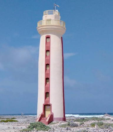
Lacre Punt Light (Willems Toren), September 2017
Wikimedia Creative Commons photo by Leslie Ket

East Coast Lighthouses
* Seru Bentana (Ceru Bentana, Ricado Winklar)
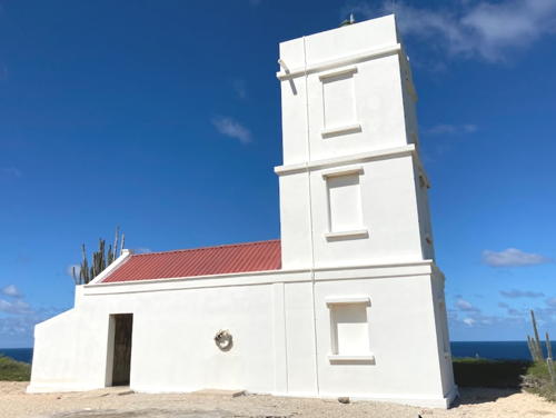
Date unknown. Active; focal plane 44 m (144 ft); four white flashes every 22 s. 10 m (34 ft) square cylindrical masonry tower attached to a small service building. Lighthouse painted white. A 2022 photo is at right, Eliot White has a June 2003 photo, Trabas has a photo by Capt. Theo, Wikimedia has a 2012 photo by Jerrye and Roy Klotz, a 2016 photo is available, and Google has a satellite view. The lighthouse was rebuilt after being heavily damaged by fire following a lightning strike in 1954. In 1999 it was renamed for Ricardo Winkler, the keeper who lost his life in the fire. The lighthouse was restored and repainted in 2012. Located on a rocky headland several miles east southeast of Malmok, near the northern tip of the island. Site open, tower closed. Site manager: Washington/Slagbaai National Park. . ARLHS NEA-002; NL 4108; Admiralty J6416; NGA 16056.
* Boca Spelonk
1910. Active; focal plane 30 m (100 ft); white flash every 5 s. 21 m (69 ft) round cylindrical masonry tower with gallery and a modern aluminum lantern. Lighthouse painted white. The keeper's house is in ruins. Döhle has a photo, Trabas has a view from the sea by Capt. Theo, Martin Mobers has a 2015 photo, a 2020 photo is available, Wikimedia has photos, and Google has a satellite view. The lantern was added sometime after 2015. Located on a promontory at the eastern tip of the island. Accessible only by foot or 4WD. Site open; Döhle was able to climb the tower in 2002 but appears to be closed today. . ARLHS NEA-001; NL 4109; Admiralty J6414; NGA 16064.
* Lacre Punt (Willems Toren)
Date unknown (station established 1837). Active; focal plane 23 m (75 ft); white flash every 9 s. 21 m (69 ft) round cylindrical masonry tower with gallery; lantern removed; solar-powered beacon. Lighthouse painted white with four narrow vertical red stripes. 1-story keeper's house in ruins. Leslie Ket's photo appears at the top of this page, Trabas has Arndt's closeup photo, Döhle has a photo, D.W. Ward has a photo, Alida Thorpe has a January 2006 photo, Wikimedia has photos, Google has a street view, and Google has a satellite view. Located at the southern tip of the island. Site open, tower closed. . ARLHS NEA-012; NL 4110; Admiralty J6411; NGA 16100.


Seru Bentana Light, November 2022
Google Maps photo by Robert


West Coast Lighthouses
Zoutsteiger Pier
Date unknown. Active; focal plane 35 m (115 ft); continuous red light. Approx. 30 m (98 ft) mast atop a square skeletal tower. Trabas has Capt. Peter's photo, Danny Woudenebrg has a 2024 photo, Waldo Corrales has a 2023 view from shore, and Bing has a satellite view. Located on the salt pier on the southwest coast of Bonaire. Site and tower closed but there's a good view from the beach. Owner/site manager: Cargill Corporation. NL 4117; Admiralty J6410.3.
* Punt Vierkant (Belnem)
Date unknown. Active; focal plane 9 m (30 ft); three white flashes, separated by 5.5 s, every 22 s. 7 m (23 ft) square pyramidal concrete tower, painted white. Trabas has Capt. Peter's photo, a closeup is available, Willians Cassiani has a street view, and Google has a satellite view. Located adjacent to the Lighthouse Beach Resort at Belnem, about 5 km (3 mi) south of Kralendijk. Site open, tower closed. NL 4115; Admiralty J6409; NGA 16096.
* Kralendijk (Fort Oranje) (3)
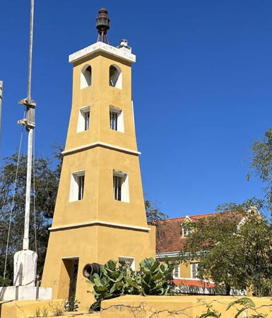
1932 (station established 1837). Active; focal plane 13 m (44 ft); white flash every 2 s. 7 m (23 ft) square tapered-pyramidal stone tower, painted a light tan. Matt Kieffer's photo is at right, Jeroen Rougoor has a 2022 photo, David Kirsch has a 2012 photo, Döhle has a good photo, Trabas has a closeup photo by Capt. Peter, Wikimedia has photos, Willians Cassiani has a street view, and the tower is centered in a Google satellite view. The light station now serves as the harbor master's office. Located on the site of a seventeenth century fort adjoining the cruise ship docks at Kralendijk, on the west side of the island. Site open, tower status uncertain. ARLHS NEA-007; NL 4113; Admiralty J6408.3; NGA 16093.
[Klein Bonaire]
Date unknown. Active; focal plane 6 m (20 ft); two white flashes every 20 s. 6 m (20 ft) post adjacent to a square 1-story equipment shelter. Trabas has a photo by Capt. Peter and Bing has an indistinct satellite view. Klein Bonaire is a small uninhabited island off Kralendijk. Located on the western tip of the island. Accessible only by boat. Site open, tower closed. ARLHS NEA-005; NL 4112; Admiralty J6406; NGA 16088.
[Punt Wekoewa (Wecua Point)]
Date unknown. Active; focal plane 15 m (49 ft); three white flashes every 20 s. 11 m (36 ft) post adjacent to a square 1-story equipment shelter. Trabas has a photo by Capt. Peter, Diego Acevedo has a street view, and the shadow of the light is seen in Bing's satellite view. Located on a promontory on the steep northeast coast of Bonaire; accessible by an unpaved road. Site open, tower closed. ARLHS NEA-011; NL 4100; Admiralty J6403; NGA 16060.
* Malmok
Date unknown. Inactive. Approx. 7.5 m (25 ft) round stone tower in ruins. 1-story keeper's house also in ruins. Martin Mobers has a good 2016 photo, Döhle has a photo, Keith Sheridan has a March 2005 photo, Wikimedia has a photo, Willians Cassiani has a street view, and Bing has a fuzzy satellite view. Located at the northern tip of the island. Site open. Site manager: Washington/Slagbaai National Park. Site open, tower closed. ARLHS NEA-013.

Information available on lost lighthouses:


Kralendijk (Fort Oranje) Light, September 2019
Wikimedia Creative Commons photo by Matt Kieffer

Notable faux lighthouses:

Adjoining pages: South: Eastern Venezuela | West: Curaçao

Return to the Lighthouse Directory index | Ratings key

Posted April 21, 2006. Checked and revised March 3, 2024. Lighthouses: 8. Site copyright 2024 Russ Rowlett and the University of North Carolina at Chapel Hill.