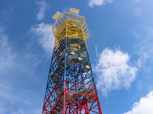
Lighthouses of Eastern Venezuela

Located on the north coast of South America, the Bolivarian Republic of Venezuela has a long coastline facing the Caribbean Sea. This page includes lighthouses of the eastern half of that coast, from the La Guaira-Caracas area eastward. The Western Venezuela page includes lighthouses on the remainder of the coast. In addition Venezuela administers a number of islands in a westward extension of the Lesser Antilles chain. The lighthouses of the Isla Margarita and Venezuela's other Caribbean islands are listed on the Venezuela: Caribbean Islands page.

Venezuela is a federal republic of 23 states, a capital district, and a federal territory administering the more remote Caribbean islands.

The word for a lighthouse is faro in Spanish; smaller lighthouses are often called balizas (beacons). In Spanish isla is an island, cabo is a cape, punta is a promontory or point of land, péñon is a rock, arrecife is a reef, bahía is a bay, ría is an estuary or inlet, estrecho is a strait, río is a river, and puerto is a port or harbor.

Active lighthouses in Venezuela are owned by the navy and managed by the Oficina Coordinadora de Hidrografía y Navegación (Ochina).

Special note: Following the election of President Nicolás Maduro in 2013 economic conditions in Venezuela deteriorated, leading to an outbreak of civil unrest. As of this revision (May 2024) the country is still not safe for tourists and other visitors.

ARLHS numbers are from the ARLHS World List of Lights. Admiralty numbers are from volume J of the Admiralty List of Lights & Fog Signals. U.S. NGA numbers are from Publication 110.

General Sources
Online List of Lights - Venezuela
Photos by various photographers posted by Alexander Trabas. The Venezuelan photos are mostly by Capt. Peter Mosselberger ("Capt. Peter") or Capt. Theodore Hinrichs ("Capt. Theo").
Lighthouses in Venezuela
Photos by various photographers available from Wikimedia.
World of Lighthouses - Venezuela
Photos by various photographers available from Lightphotos.net.
Señales Marítimas Venezolanas
Posted by DHN, a map locates the Venezuelan lighthouses with their names and geographic coordinates.
Lighthouses of Venezuela
Historic postcard images posted by Michel Forand.
Leuchttürme Südamerikas auf historischen Postkarten
Historic postcard images posted by Klaus Huelse.
Navionics Charts
Navigation chart for Venezuela.

La Sabana Light
La Sabana Light, La Sabana
OCHINA photo

La Guaira State Lighthouses
La Guaira, the capital of the state of La Guaira, is the principal port of Venezuela. It has a population of about 275,000 and is only 30 km (19 mi) northwest of the national capital, Caracas. The name of the state was changed from Vargas to La Guaira in 2019.
Puerto La Cruz (2?)
Date unknown. Active; focal plane 321 m (1053 ft); white flash every 10 s. Listed by NGA as a 12 m (39 ft) round fiberglass tower, painted with orange and white horizontal bands. Trabas has Capt. Theo's photo showing a square skeletal tower and Google has a satellite view. This is one of the world's highest lighthouses. Located on a mountaintop just west of Puerto La Cruz and about 60 km (38 mi) west of La Guaira. (This Puerto La Cruz should not be confused with a much larger port of the same name in eastern Venezuela; see below.) Site status unknown. ARLHS VEN-045; Admiralty J6453.5; NGA 17037.
Catia La Mar (Escuela Naval)
Date unknown. Active; focal plane 99 m (325 ft); white flash every 9 s. 12 m (39 ft) hexagonal fiberglass tower, painted red with a white horizontal band. Trabas has Capt. Theo's distant view and Google has a satellite view. Located atop a vertical cliff in front of the Venezuelan Naval School in Catia La Mar, about 12 km (7.5 mi) west of La Guaira. Site status unknown. ARLHS VEN-047; Admiralty J6453.8; NGA 17039.
#La Guaira South Breakwater
1951. Inactive since 2016 and removed by 2017. This was a 13 m (43 ft) hexagonal fiberglass tower, painted with red and white horizontal bands. The lowest story of the tower was covered with a brick veneer. Google's satellite view confirms the removal of the light. The Admiralty reported this light deactivated in December 2016. Located on a very short breakwater on the south side of the entrance to the harbor of La Guaira. Site status unknown. ARLHS VEN-011; ex-Admiralty J6459; NGA 17068.
La Rada (La Guaira Inner Breakwater)
Date unknown. Active; focal plane 13 m (43 ft); red flash every 2.5 s. 10 m (33 ft) hexagonal fiberglass tower, painted red with a white horizontal band. Trabas has Capt. Theo's photo and Google has a satellite view. Located at the end of the inner breakwater of La Guaira harbor. This pier is used by the Venezuelan Navy. Site and tower closed. ARLHS VEN-037; Admiralty J6460.3; NGA 17069.
La Guaira North Breakwater (4?)
1951 (station established 1890). Active; focal plane 14 m (46 ft); green flash every 3.7 s. 10 m (33 ft) hexagonal fiberglass tower, painted green with a white horizontal band. Trabas has Capt. Theo's photo (also seen at right) and Google has an indistinct satellite view. Forand has a postcard view of the third (1937) tower. Located at the end of the north breakwater, the main breakwater protecting the harbor of La Guaira. Site status unknown. Admiralty J6459.5; NGA 17064.


North Breakwater Light, La Guaira
photo copyright Capt. Theo Hinrichs; used by permission

La Guaira
Date unknown. Active; focal plane 425 m (1394 ft) (?); one long (2 s) white flash every 15.5 s. Light centered atop a round water tank, painted with orange and white horizontal bands. Trabas has Capt. Theo's photo and Google has a satellite view. This light may have been relocated and its focal plane may be less than the listed height. Located on the steep mountain ridge south of La Guaira. Site open, tower closed. Admiralty J6458.5; NGA 17058.
Marina de Caraballeda Inner Breakwater
Date unknown. Active; focal plane 7 m (23 ft); red flash every 8 s. 6 m (20 ft) round hexagonal fiberglass tower colored with red and white horizontal bands. Ricardo Ruiz has a photo, Trabas has Capt. Theo's photo, and Google has a satellite view. Located on the inner breakwater of the marina at Caraballeda on the east side of La Guaira. Site status unknown. Admiralty J6461.52; NGA 17074.
Marina de Caraballeda Outer Breakwater
Date unknown. Active; focal plane 7 m (23 ft); green flash every 8 s. 6 m (20 ft) round strongly-conical fiberglass tower colored with green and white horizontal bands. Trabas has Capt. Theo's photo and Google has a satellite view. Located on the main breakwater of the marina at Caraballeda on the east side of La Guaira. Site status unknown. ARLHS VEN-052; Admiralty J6461.5; NGA 17073.
Club Puerto Azul
Date unknown. Active (probably privately maintained); focal plane 55 m (180 ft); white flash every 11 s. Light mounted atop a tall beachfront condo tower. Google has a street view and a satellite view. Located on the beach at Naiguatá, about 10 km (6 mi) east of La Guaira. Site status unknown. Owner/site manager: Club Puerto Azul. Admiralty J6461.85; NGA 17077.
* Naiguatá
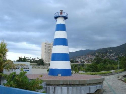
Date unknown. Active (probably privately maintained); focal plane 16 m (52 ft); white flash every 2 s. Approx. 13 m (43 ft) round strongly conical concrete tower, painted with blue and white horizontal bands. Andrés E. Parilli has the 2018 photo seen at right, Trabas has Capt. Theo's view from the sea, and Google has a satellite view. Located near the base of the marina breakwater. Site open, tower closed. Owner/site manager: Club Puerto Azul. ARLHS VEN-015; Admiralty J6461.6; NGA 17076.
* La Sabana (2?)
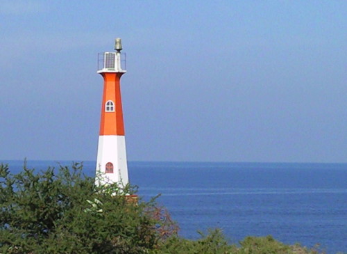
Date unknown. Active; focal plane 60 m (197 ft); white flash every 7.5 s. 10 m (33 ft) hexagonal fiberglass tower, colored orange with one white horizontal band. Ochina's "wallpaper" photo is at the top of this page, Briseida Ascanio has a black-and-white photo and Google has a satellite view. Located on a point of land on the west side of La Sabana. Site open, tower closed. ARLHS VEN-042; Admiralty J6461.95; NGA 17082.

Naiguatá Light, Puerto Azul, August 2018
Google Maps photo by Andrés E. Parilli

Miranda State Lighthouses
Cabo Codera
Date unknown. Active; focal plane 168 m (551 ft); white flash every 6 s. 10 m (33 ft) hexagonal fiberglass tower, colored orange with one white horizontal band. ARLHS has a photo and Google has a distant satellite view. Located atop a very steep headland about 100 km (65 mi) east of Caracas. Site and tower closed. ARLHS VEN-031; Admiralty J6469; NGA 17084.
* Bahía de los Piratas (Puerto Carenero)
Date unknown. Active; focal plane 42 m (138 ft); white flash every 10 s. Light mounted atop the high-rise Club Bahía de los Piratas. The light can be seen in a photo by Alejandro A. Vilagut C., Mauricio Lopez has a street view across the harbor, and Google has a satellite view. Located on the waterfront of Puerto Carenero. Site open, tower closed. Admiralty J6470; NGA 17085.

Anzoátegui State (Puerto la Cruz Area) Lighthouses
Machurucuto
Ariund 2020. Active; focal plane and light characteristics unknown. Light mounted atop a motel or hotel in the beach resort of Machurucuto. No photo available but Bing has a fuzzy satellite view. Located about 250 m (800 ft) off the beach in Machurucuto. Site open, tower closed. Admiralty J6477.6.
Unare
2008. Active; focal plane 15 m (49 ft); white flash every 12.5 s. 12 m (39 ft) octagonal fiberglass tower. No photo available but Bing has an indistinct satellite view. Located at the mouth of the Río Unare, about 15 km (9 mi) west of Puerto Piritu. Site status unknown. Admiralty J6477.5; NGA 17087.
Islas Piritu (Isla de Afuera) (2)
2012. Active; focal plane 20 m (66 ft); white flash every 10 s. Approx. 18 m (59 ft) round tower with lantern and gallery, painted with red and white horizontal bands. Trabas has Capt. Peter's distant view and Google has a satellite view. Ramon Nuñez has a 2010 photo of the first lighthouse showing yellow, blue and red horizontal bands (the colors of the Venezuelan flag). The Islas Piritu are two islands lying about 7 km (4.5 mi) offshore northeast of Puerto Piritu. Located at the western end of the western island, Isla de Afuera ("Outer Island"). Accessible only by boat. Site open, tower closed. ARLHS VEN-016; Admiralty J6478; NGA 17088.
Isla de Adentro (Islas Piritu East) (2?)
Date unknown. Active; focal plane 16 m (52 ft); white flash every 7.5 s. Approx. 15 m (49 ft) round cylindrical tower, painted with red and white horizontal bands. Christian Gamboa has a 2020 photo and Bing has a satellite view. Trabas has Capt. Theo's distant view of what appears to an earlier and more slender lighthouse. Located at the eastern end of the eastern island, Isla de Adentro. Accessible only by boat. Site open, tower closed. ARLHS VEN-046; Admiralty J6478.2; NGA 17088.5.
Isla Borrachitos del Este
Date unknown. Active; focal plane 116 m (381 ft); white flash every 15 s. Approx. 11 m (36 ft) hexagonal fiberglass tower, painted red with a white horizontal band. Trabas has Capt. Peter's distant view, Ramon Nuñez has a distant view from the sea, and Bing has a distant satellite view. Located on a small but high island obstructing the western approach to Puerto la Cruz, about 12 km (7.5 mi) west northwest of the port. Accessible only by boat. Site open, tower closed. Admiralty J6479; NGA 17089.
La Borracha (Cayo Borracha)
Date unknown. Active; focal plane 381 m (1250 ft); white flash every 6 s. Approx. 14 m (46 ft) square skeletal tower with gallery, painted orange with one white horizontal band. Trabas has Capt. Peter's distant view, Ramon Nuñez has a very distant view, and Google has a distant satellite view. La Borracha is a high island about 5 km (3 mi) long located 15 km (9 mi) northwest of Puerto la Cruz. Located at the highest point of the island. Accessible only by boat. Site open, tower closed. Admiralty J6479.5; NGA 17090.
Isla Chimana Segunda (2)
Date unknown (station established 1931). Active; focal plane 50 m (164 ft); white flash every 10 s. Approx. 15 m (50 ft) round fiberglass tower with octagonal lantern and gallery. Tower painted with red and white horizontal bands; gallery painted with vertical red and white stripes. Matt Hamm's photo is at right, Jean Jorge Achji Z. has a 2016 photo, Rafael Méndez has a closeup, Trabas has Capt. Peter's photo, and Google has a satellite view. The island is located in Mochima National Park. Tours are available from Puerto la Cruz to the beach below the lighthouse, known as Playa el Faro, where there is shelter for day visitors. Located on a bluff at the west end of the island, roughly 40 km (25 mi) northeast of Puerto La Cruz. Accessible only by boat. Site open, tower closed. Site manager: Parque Nacional Mochima. ARLHS VEN-030; Admiralty J6481; NGA 17140.
Isla Picuda Chica
Date unknown. Active; focal plane 40 m (131 ft); white flash every 7 s. 6 m (20 ft) hexagonal fiberglass tower colored red with a white horizontal band. Trabas has Capt. Peter's photo and Google has a distant satellite view. Located atop a small island about 5 km (3 mi) northeast of Isla Chimana Segunda. Accessible only by boat. Site open, tower closed. Site manager: Parque Nacional Mochima. Admiralty J6485; NGA 17139.
Faro de Chimana Segunda
Isla Chimana Segunda Light, December 2005
Flickr Creative Commons photo by Matt Hamm

Sucre State: Caribbean Coast Lighthouses
Sucre is the easternmost state of Venezuela's Caribbean coast. A steep ridge at the northern edge of the state extends westward as the Araya Peninsula and eastward as the Paria Peninsula. The state's east coast faces Trinidad across the Gulf of Paria.
Recalada Cumaná (Cumaná Landfall) (1)
Date unknown. Inactive since 2019 and possibly removed. This is or was a 12 m (39 ft) skeletal tower, colored with orange and white horizontal bands. Robert Ayan has a distant street view but the tower is difficult to locate in Google's satellite view. Located on a hilltop in Cumaná, the capital of Sucre province. Site status unknown.
Recalada Cumaná (Cumaná Landfall) (2)
2019. Active; focal plane 20 m (66 ft); white flash every 12 s. 6 m (20 ft) skeletal tower colored orange with a white horizontal band and mounted on a 4-story building. Jorge Barrios-Montilla has a 2023 photo and Google has a satellite view. NGA continues to describe the original tower. Located on the waterfront of Cumaná's port. Site and tiwer closed. ARLHS VEN-036; Admiralty J6488; NGA 17141.
Punta Arenas (Punta Arena)
Date unknown. Active; focal plane 42 m (138 ft); white flash every 12 s. Approx. 12 m (39 ft) hexagonal (?) fiberglass tower, upper half red and lower half white, mounted on a 1-story brick base. A 2010 photo is at right, Trabas has Andreas Köhler's photo, and Bing's satellite view shows the lighthouse next to a resort development called Casas del Mar. Located near the tip of the Araya Peninsula, which shelters the harbor of the state capital, Cumaná. Site open, tower closed. ARLHS VEN-043; Admiralty J6489; NGA 17144.
Morro de Chacopata (2?)
Date unknown (station established 1937). Active; focal plane 20 m (66 ft); white flash every 15 s. Approx. 12 m (39 ft) hexagonal fiberglass tower, colored orange with one white horizontal band. Johann Napp has a distant view and Google has a satellite view. This light guides vessels in a narrow passage between the mainland and the Isla Coche. Located at the tip of the wedge-shaped Chacopata Peninsula. Site probably open, tower closed. Admiralty J6490; NGA 17148.
Punta Arenas Light
Punta Arenas Light, Punta Arenas, August 2010
ex-Panoramio photo copyright afem; permission requested
Puerto Santo (2?)
Date unknown. Active; focal plane 40 m (131 ft); white flash every 12 s. 12 m (39 ft) square skeletal tower, painted with red and white horizontal bands. Trabas has Andreas Köhler's photo, Sergio Patrón has an aerial view, and the light is visible in a Bing satellite view. NGA lists a fiberglass tower at this location. Located on a small island off a headland at the west end of a hammer-head shaped peninsula sheltering the harbor of Puerto Santo. Accessible only by boat. Site status unknown. Admiralty J6509.8; NGA 17190.
Cabo Tres Puntas (2?)
Date unknown. Active; focal plane 193 m (633 ft); white flash every 5 s. 15 m (49 ft) square skeletal tower, painted with red and white horizontal bands. Trabas has Capt. Theo's distant view from the sea and Google has a distant satellite view. NGA describes this light as a fiberglass tower. Located on a prominent cape on the north side of the Paria Peninsula, about 50 km (30 mi) northwest of Güiria. Site status unknown. ARLHS VEN-005; Admiralty J6514; NGA 17194.
Punta Mejillones
Date unknown. Active; focal plane 43 m (141 ft); one long (1.2 s) white flash every 12 s. 12 m (39 ft) round fiberglass tower, colored with orange and white horizontal bands. No photo available and the tower is not seen in Bing's fuzzy satellite view of the location. Punta Mejillones is a needle-sharp promontory, part of a ridge that continues underwater as a dangerous reef perpendicular to the coast. Located on a rock, a summit of the ridge, about 25 km (15 mi) northeast of Güiria. Accessible only by boat. Site and tower closed. Admiralty J6515; NGA 17195.
 

Puerto Santo Light, Puerto Santo, March 2012
photo copyright Andreas Köhler; used by permission
 

Sucre State: Gulf of Paria Coast Lighthouses
The Gulf of Paria is a broad but relatively shallow sea between the island of Trinidad and the east coast of Venezuela. It is connected to the Caribbean Sea to the north by straits called the Dragon's Mouths (Bocas del Dragón) and to the Atlantic Ocean on the south by a strait called the Serpent's Mouth (Boca del Serpiente).
Promontorio de Paria (Punta Peñas)
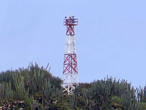
Date unknown. Active; focal plane 75 m (246 ft); white flash every 15 s. 12 m (39 ft) skeletal tower, painted with orange and white horizontal bands. Trabas has Capt. Peter's photo and Google has a distant satellite view. Located on the extreme tip of the Paria Peninsula, marking the west side of the Dragon's Mouths. Site status unknown. Admiralty J6516; NGA 17195.5.
Isla de Patos (3)
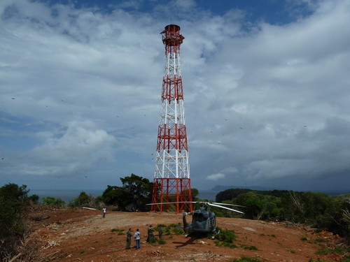
2012 (station established 1972). Active; focal plane 114 m (374 ft); white flash every 5 s. 36 m (118 ft) square cylindrical skeletal tower, painted with red and white horizontal bands. A photo is at right, Trabas has Capt. Peter's photo, Oleksiy Mustafin has a view from the sea, and Bing has a good satellite view. The Isla de Patos is a small, steep island in the southern entrance to the Dragon's Mouths, about 10 km (6 mi) east of Macuro and 15 km (9 mi) southwest of the island of Chacachacare in Trinidad and Tobago. The island was formerly in dispute between Venezuela and Great Britain, but the British ceded their claim in a 1942 treaty that fixed the marine boundary between Venezuela and Trinidad in the Gulf of Paria. The island is administered as a federal territory, part of the Dependencias Federales. Located on the highest point of the island, near the west end. Accessible only by boat. Site and tower closed. ARLHS VEN-039; Admiralty J6517; NGA 17200.
Macuro
Date unknown. Active; focal plane 76 m (249 ft); white flash every 4 s. 6 m (20 ft) hexagonal tower, painted red with a white horizontal band. The lighthouse peeks above the tree line at upper left in Jorge Barrios-Montilla's photo and Google has a distant satellite view. Macuro is the easternmost town on the Paria Peninsula, about 15 km (9 mi) west of the Dragon's Mouth on the south side of the Paria Peninsula. Located high on a promontory on the east side of the harbor. Site status unknown. Admiralty J6518; NGA 17196.
Isla de Patos Light
Isla de Patos Light, Bocas del Dragón, November 2012
OCHINA photo
Puerto Hierro
Date unknown. Active; focal plane 65 m (213 ft); white flash every 6 s. Skeletal tower, height unknown, painted with orange and white horizontal bands. No photo available but Google has a satellite view. Located on a promontory on the east side of Puerto Hierro, a small port on the south side of the Paria Peninsula about halfway between Macuro and Güiria. Site status unknown. Admiralty J6521; NGA 17204.
Güiria (Recalada Güiria, Güiria Landfall) (3)
2010 (station established 2000). Active; focal plane 33 m (108 ft); white flash every 10 s. Approx. 25 m (82 ft) rectangular masonry tower with lantern and gallery. A photo is at right, an aerial photo is available, there's a photo of the new lighthouse under construction next to the old one, and and Google has a satellite view. The first light at Güiria was mounted on a water tank in 1941. Located on a slope above the sea about 1 km (0.6 mi) northeast of the harbor. Site open, tower closed. Admiralty J6524; NGA 17210.
Güiria East Breakwater (2)
1990 (station established 1951). Active; focal plane 10 m (33 ft); red flash every 9 s. 9 m (30 ft) skeletal tower mounted on a round, vase-shaped white concrete base. The skeletal portion of the tower is red. A photo is available, Carlos Olmo Bosco has a view taken from a ferry arriving in Güiria from Trinidad, and Google has a satellite view. Located at the end of the long, curving east breakwater of Güiria. Accessible only by boat. Site status unknown. Admiralty J6525; NGA 17212.
Güiria South Breakwater (2)
1990 (station established 1951). Active; focal plane 5 m (17 ft); green flash every 9 s. 4 m (13 ft) skeletal tower mounted on a round, vase-shaped white concrete base. The skeletal portion of the tower is green. No photo available but Google has a satellite view. Located at the end of the long, curving east breakwater of Güiria. Accessible only by boat. Site status unknown. Admiralty J6526; NGA 17216.
Güiria Light
Güiria Light, Güiria, November 2010
OCHINA photo

Delta Amacuro State Lighthouses
Isla Cotorra (Punta Barrial)
Date unknown. Inactive since 2021. 12 m (39 ft) round fiberglass tower, colored with orange and white horizontal bands. No photo available and the light is not seen in Google's satellite view of the area. The Isla Cotorra is on the south side of the Gulf of Paria; the light here helps guide vessels into the Serpent's Mouth, the strait between Venezuela and the southwestern tip of Trinidad. Located at the northern tip of the island. Site status unknown. ARLHS VEN-028; ex-Admiralty J6615; NGA 17227.
Punta Barima (Isla Corocoro) (3?)
Date unknown (station established 1906). Active; focal plane 24 m (79 ft); white flash every 10 s. 15 m (49 ft) square skeletal tower, painted with red and white horizontal bands, mounted on a square platform supported by piles. Carlos Blanco has a photo, Trabas has a distant view by Capt. Theo, and Bing has a satellite view. Huelse has a historic postcard view of a 115 ft (35 m) hexagonal skeletal tower atop a 1-story keeper's house; this lighthouse was apparently completed in 1910. Its fate is not known. Located beside a pier at Punta Barima, a small station on the south side of the southernmost entrance to the Orinoco River, about 50 km (30 mi) west of the Guyanan border. Admiralty J6800; NGA 17242.

Information available on lost lighthouses:

Notable faux lighthouses:

Adjoining pages: North: Venezuelan Caribbean | East: Trinidad and Tobago | Southeast: Guyana | West: Western Venezuela

Return to the Lighthouse Directory index

Posted July 7, 2003. Checked and revised May 28, 2024. Lighthouses: 37. Site copyright 2024 Russ Rowlett and the University of North Carolina at Chapel Hill.