Lighthouses of Brazil: Bahia

The Federative Republic of Brazil, the largest country in South America and fifth largest in the world, has a lengthy coastline, a large number of lighthouses, and a distinguished lighthouse history. Colonized by Portugal, Brazil declared its independence in 1822. Uniquely among American nations it was a monarchy as the Empire of Brazil until 1889.

Brazil is a federation of 26 states and a federal district. This page covers lighthouses of the state of Bahia on Brazil's northeastern coast. one of the nine states in Brazil's Northeast Region. Bahia is Brazil's fifth largest state and it includes the longest coastline of any of the states. The tropical coastline faces across the South Atlantic Ocean towards Africa. The largest port in Bahia by far is the capital, Salvador (São Salvador da Bahia de Todos os Santos); Ilhéus is another important port.

The Portuguese word for a lighthouse is farol, plural faróis. In Brazilian use, the word farol generally applies to all light towers, regardless of whether they are enclosed structures or not. The word farolete or farolim is sometimes used for smaller towers. In Portuguese ilha is an island, ilhéu is an islet, cabo is a cape, ponta is a promontory or point of land, rocha is a rock, recife is a reef, baía is a bay, estreito is a strait, rio is a river, and porto is a port or harbor.

Active lighthouses in Brazil are owned by the navy (Marinha do Brasil) and maintained by the Centro de Auxílios à Navegação Almirante Moraes Rego (CAMR) in the Diretoria de Hidrografia e Navegacão (DHN). Many of the larger lighthouses are staffed by resident keepers or by rotating crews of naval personnel. Only a small number of Brazilian lighthouses are open to the public.

ARLHS numbers are from the ARLHS World List of Lights. BR numbers are from the official Brazilian Lista de Faroís. Admiralty numbers are from volume G of the Admiralty List of Lights & Fog Signals. U.S. NGA numbers are from Publication 110.

General Sources
Faroís Brasileiros
This web site for Brazilian lighthouses has small photos and historical information for many of the major lights.
Online List of Lights - Brazil
Photos by various photographers posted by Alexander Trabas. Photos from the Salvador area are mostly by Capt. Peter Mosselberger ("Capt. Peter").
Lighthouses in Bahia
Photos by various photographers available from Wikimedia.
World of Lighthouses - Brazil
Photos by various photographers available from Lighthouses.net.
Lista de faróis do Brasil
Index to articles on the Portuguese Wikipedia (many with photos).
Lista de Faróis
The official Brazilian light list.
Leuchttürme Südamerikas auf historischen Postkarten
Historic postcard views posted by Klaus Huelse.
GPSNauticalCharts
Navigational chart information for Bahia.
Navionics Charts
Navigation chart for Brazil.


Santo Antônio da Barra Light, Salvador, August 2010
ex-Flickr Creative Commons photo
by Vitor D'Agnoluzzo

Northern Bahia (Coconut Coast) Lighthouses
* Mangue Seco
1996. Active; focal plane 55 m (180 ft); white flash every 6 s. 25 m (82 ft) square cylindrical skeletal tower, painted white and carrying a horizontally slatted white daymark. Lucineia Neia has a 2019 photo, Carla Alencar has a view from the bay, Nelson Mattos Filho has a view from the sea, and Google has a satellite view. Mangue Seco ("Dry Mangrove") is a small fishing village and beach resort located at the end of a sandy peninsula at the northern border of Bahia. Site open, tower closed. BR-1440; Admiralty G0234.2; NGA 18012.
Itariri
Date unknown. Active; focal plane 75 m (246 ft); white flash every 10 s, with every 6th flash omitted. 30 m (98 ft) square cylindrical concrete tower, painted with black and white horizontal bands. A closeup photo (second photo on the page) and a distant view are available, George Gomes has a drone view, and Google has a satellite view. Located at Barra do Itariri about 135 km (85 mi) north of Salvador. Site status unknown. ARLHS BRA-224; BR-1441; Admiralty G0234.5; NGA 18013.
* Subaúma
1992. Active; focal plane 48 m (157 ft); white flash every 10 s. 41 m (135 ft) square cylindrical concrete tower, painted with red and white horizontal bands. César Lethier has a photo, Railson da Luz has a view from the beach, João Eduardo Penna de Carvalho also has a view, Klowyz Poeira Cósmica has a street view from the beach, and Google has a street view and a satellite view. Located just off the beach at Subaúma, about 30 km (19 mi) southwest of Barra do Itariri. Site open, tower closed. ARLHS BRA-243; BR-1442; Admiralty G0235; NGA 18014.
* Garcia d'Avila (Praia do Forte) (2)
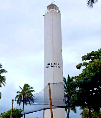
1971 (station established 1916). Active; focal plane 92 ft; two white flashes every 12 s. 82 ft round cylindrical concrete tower with lantern and gallery; entire lighthouse painted white. A photo is at right, David Vignoni has a photo, Gilberto Sander Müller has a 2018 photo, Trabas has a view from the sea by Capt. Peter Mosselberger, and Google has a street view and a satellite view. The original cast iron lighthouse was lost to beach erosion. The area was named for the Castelo Garcia d'Avila, a 16th century fortified house; more recently it has become popular as a seaside resort known as Praia do Forte (Fort Beach). A sea turtle refuge and conservation center called Projeto Tamar is located next to the lighthouse. Located on the beach at Praia do Forte, about 50 miles northeast of Salvador. Site open, tower closed. ARLHS BRA-037; BR-1444; Admiralty G0236; NGA 18016.
Farol de Garcia d'Avila
Garcia d'Avila Light, January 2007
Flickr Creative Commons photo by npstr (no longer online)
Camaçari
Date unknown. Active (privately maintained?); focal plane 20 m (66 ft); white flash every 10 s. 20 m (66 ft) round concrete tower, painted white. Marlon Cardoso Trindade has a photo, Trabas has a view from the sea by Capt. Peter, Catia Gomes has the view from the beach, and Google has a satellite view and a distant street view. Located at the end of a pier in Camaçari, an industrial port about 25 miles northeast of Salvador. Site status unknown. Site manager: Cetrel, SA. ARLHS BRA-125; BR-1446; Admiralty G0236.2; NGA 18018.
* Arembepe
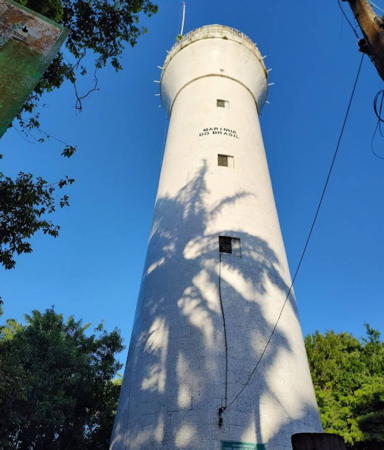
Date unknown. Active (privately maintained); focal plane unknown; continuous red light. Approx. 25 m (82 ft) round white concrete tower. This is probably a water tower. Trabas has a view from the sea by Capt. Peter and Google has a street view and a satellite view. Located on heights behind the beach resort town of Arembepe. Site open, tower closed. BR-1448; Admiralty G0236.4.

Salvador Area Lighthouses
The state capital of Salvador is the largest city of northeastern Brazil with a population approaching three million. Founded in 1549, it was the capital of Brazil until 1763. It has always been a major port, thanks to its location facing the Bahia de Todos os Santos (Bay of All Saints). The bay is roughly 50 km (30 mi) long east to west and 25 km (15 mi) wide.
* Itapuã (Itapoã)
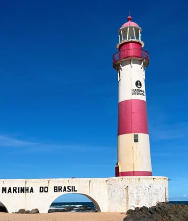
1873. Active; focal plane 24 m (79 ft); white flash every 6 s. 21 m (69 ft) round cast iron tower with lantern and gallery, mounted on a concrete base and connected to shore by an arched concrete bridge. Lighthouse painted with red and white horizontal bands; lantern and gallery are red. Leandro Mundim's photo is at right, Dôra Araújo has a good photo, Luiz Augusto Pizzato has a good photo, Wikimedia has several good photos, Trabas has Erich Hartmann's view from the sea, Huelse has a historic postcard view, and Google has a street view and a satellite view. A Navy housing compound is located behind the lighthouse. This is one of nine cast iron lighthouses prefabricated for Brazil by P & W McLellan of Glasgow, Scotland. Note: there is another Farol Itapuã in Rio Grande do Sul (see Southern Brazil). Located at the surf line on the beach at Ponta Itapuã, about 20 km (13 mi) east northeast of the Farol de Barra (next entry). Site open, tower closed. . ARLHS BRA-058; BR-1460; Admiralty G0238; NGA 18024.
**** Santo Antônio da Barra ("Farol da Barra") (2)
1839 (station established 1698). Active; focal plane 39 m (128 ft); white light on 5 s, off 5 s, except every third showing is red rather than white. 22 m (72 ft) round tapered tower with lantern and gallery, painted with black and white horizontal bands. A Fresnel lens (1890) is in use. The lighthouse is built atop the Forte de Santo Antônio da Barra, a historic fortification dating from the sixteenth century. Vitor D'Agnoluzzo's photo is at the top of this page, a fine 2007 photo is available, Wikimedia has many photos, Trabas has Capt. Peter's photo, Huelse has a historic postcard view, Lucas Tadeu Pereira Sodré has a closeup street view, and Google has a good satellite view. A light was displayed from the fort as early as 1698, leading to a claim that this is the oldest light station in the Americas (there are other claimants). One of Brazil's best known lighthouses and one of Bahia's best known attractions. In 1998 the fort and lighthouse were restored and converted to a maritime museum, the Museu Náutico da Bahia; there is also a coffee shop. Located on the Ponta de Santo Antônio marking the east side of the entrance to the Bahia Todos os Santos, the harbor of Salvador, Bahia's state capital and Brazil's colonial capital. Site open; museum open Sundays; in 2011 the tower was also opened to visitors. Site manager: Museu Náutico de Bahia. . ARLHS BRA-096; BR-1472; Admiralty G0242; NGA 18028.
Salvador South Breakwater (2)
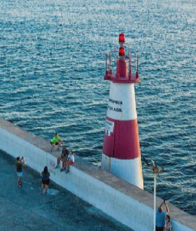
Date unknown. Active; focal plane 10 m (33 ft); red flash every 3 s. 6 m (20 ft) round barbell-shaped red fiberglass tower. Google has a satellite view. Trabas has a photo by Thomas Philipp and Robert English also has a photo of the original light, a hexagonal pyramidal concrete tower. Located at the end of the breakwater, about 6 km (3.5 mi) north of the Farol da Barra. Site and tower closed. BR-1488; Admiralty G0246; NGA 18036.
Itapuã Light
Itapuã Light, Salvador, December 2012
Flickr Creative Commons photo by Leandro Mundim
Salvador North Breakwater South End
Date unknown. Active; focal plane 6 m (20 ft); green flash every 3 s. 6 m (20 ft) hexagonal pyramidal concrete tower, painted green. Trabas has Erich Hartmann's photo, Robert English has a photo, and Google has a satellite view. Located at the south end of a detached breakwater, just north of the south breakwater. Accessible only by boat. Site and tower closed. BR-1492; Admiralty G0247; NGA 18040.
Salvador North Breakwater North End
Date unknown. Inactive since 2021. 6 m (20 ft) hexagonal pyramidal concrete block tower, painted yellow. Trabas has Erich Hartmann's photo and Google has an indistinct satellite view. Located at the north end of the detached breakwater. Accessible only by boat. Site and tower closed. ex-BR-1496; ex-Admiralty G0247.2; NGA 18044.
* Monte Serrat (Ponta do Humaitá) (2?)
1935 (station established 1864). Active; focal plane 10 m (33 ft); red flash every 10 s. 10 m (33 ft) round strongly conical concrete tower, painted with red and white horizontal bands. Erica Almeida's photo is at right, Raquel Alençar Vieira has a closeup photo, Wikimedia has several photos, Trabas has a photo by Günther Hess, Huelse has a historic postcard view, and Google has a street view and a satellite view. The original light was described as a white pillar on the fort. Located near the historic Forte Monte Serrat on a promontory on the east side of the Bahia Todos os Santos, about 10 km (6 mi) north of the Farol da Barra. Site open, tower closed. . ARLHS BRA-156; BR-1500; Admiralty G0249; NGA 18048.
Itamoabo
Date unknown. Active; focal plane 50 m (164 ft); two quick white flashes every 3 s. 5 m (17 ft) round white concrete tower. Trabas has Capt. Peter's distant view and Google has a satellite view. Located atop a bluff at the southwest corner of the Ilha Itamoabo, an island in the northeast corner of the Bahia Todos os Santos. Site status unknown. BR-1613; Admiralty G0256; NGA 18066.
Caboto
Date unknown. Active; focal plane 34 m (112 ft); white flash every 6 s. 8 m (26 ft) square cylindrical concrete tower, painted white. Trabas has Capt. Peter's photo and Google has a satellite view. Located on a promontory near the northeastern corner of the Bahia Todos os Santos, about 25 km (15 mi) north of the Farol da Barra. Site status unknown. ARLHS BRA-019; BR-1612; Admiralty G0254; NGA 18060.

Monte Serrat Light, Salvador, October 2013
Wikimedia Creative Commons photo by Erica Almeida for Turismo Bahia
* Ilha do Frade (Ilha dos Frades) (2)
Date unknown (station established 1892). Active; focal plane 35 m (115 ft); two quick white flashes every 6 s. 5 m (17 ft) square cylindrical white concrete tower. A 2018 closeup photo is available, Juliano Teixeira has a 2018 street view, Google has a satellite view. The original light was on an iron pillar. The Ilha dos Frades is a large island in the northern portion of the Bahia Todos os Santos. Located at the south point of the island in front of the historic church of Nossa Senhora de Guadalupe. Site open, tower closed. ARLHS BRA-045; BR-1696; Admiralty G0266; NGA 18132.
Recife de Ouréis
Date unknown. Active; focal plane 8 m (26 ft); two white flashes every 10 s. 8 m (26 ft) square cylindrical concrete tower painted with black and red horizontal bands. No photo available but Google has a satellite view. Located on a reef in the northwestern arm of the Bahia Todos os Santos about 2 km (1.25 mi) northwest of the Ilha dos Frades. Accessible only by boat. Site open, tower closed. BR-1700; Admiralty G0267; NGA 18128.
Mar Grande
Date unknown. Active; focal plane 8 m (26 ft); white flash every 3 s. 8 m (26 ft) square cylindrical concrete tower painted white. Google has a satellite view and a distant street view. Located on a reef on the west side of the entrance to the Bahia Todos os Santos. Accessible only by boat. Site open, tower closed. BR-1772; Admiralty G0244; NGA 18032.

Ilha de Tinharé Lighthouse
* Morro de São Paulo ("Farol do Morro")
1885. Active; focal plane 89 m (292 ft); two white flashes every 15 s. 26 m (85 ft) round stone tower with lantern and gallery, painted white. 3rd order Fresnel lens in use. A 2022 photo is at right, Afonso Oliva has a closeup, Wikimedia has photos, Leonardo Vianna has a good view from the beach, and Google has a satellite view. The lighthouse is built uphill from the ruins of a fort built in 1630. Located at the northeastern tip of the Ilha de Tinharé, about 80 km (50 mi) southwest of Salvador; the island, a popular resort, is accessible by ferry from Valença or Salvador. Accessible by a popular hiking trail. Site open, tower closed. . ARLHS BRA-157; BR-1776; Admiralty G0274; NGA 18148.

Morro de São Paulo Light, Cairu, December 2022
Google Maps photo by Wander

Itacaré Area Lighthouses
Quiepe
Date unknown (station established 1909). Inactive. 16 m (52 ft) square cylindrical concrete tower, painted white. No closeup photo available. An aerial photo is available and Google has a satellite view of the station. The Ilha de Quiepe lies in the entrance to the bay of Camamu, about 100 km (60 mi) southwest of Salvador. The island is privately owned. Located on the north coast of the island. Accessible only by boat. Site and tower closed. ex-Admiralty G0278.
* Ponta do Mutá
Date unknown. Active; focal plane 11 m (36 ft); green flash every 3 s. 10 m (33 ft) square cylindrical concrete tower, painted white. Luiz Damião Araújo has a closeup photo, João Júnior has a photo, Raimundo Magalhães has a 2022 photo, an aerial view is available, and Google has a satellite view. Located at the tip of the long Maraú peninsula, marking the south side of the entrance to the bay of Camamu. Accessible by road. Site open, tower closed. ARLHS BRA-177; BR-1782; Admiralty G0279; NGA 18154.
* Morro de Taipú (Taipus)
Date unknown. Active; focal plane 76 m (249 ft); three white flashes every 15 s. 10 m (33 ft) square cylindrical concrete tower, painted with red and white horizontal bands. Donizete Souza Prado has a 2020 photo, André Vinicius has a closeup, Rafael Keunecke has a 2009 view from the sea, Luiz Felipe da Silva de Castro has a view from the bay of Camamu, Marcos Oliveira has a closeup street view, and Google has a satellite view. Located on the high ridge of the Maraú peninsula, about 9 km (5.5 mi) south of Ponta do Mutá. Accessible by road. Site open, tower closed. . BR-1783; Admiralty G0280; NGA 18155.
Contas (Ilhota de Contas, Itacaré) (2)
Date unknown (station established 1929). Active; focal plane 18 m (60 ft); white flash every 10 s. 20 m (66 ft) square cylindrical masonry tower, painted white. No lantern. Gabriel Alves has the 2021 photo seen at right, Wikimedia has a photo by Andres Umida (also seen at right), Mario Castro has a 2009 photo, Luís Henrique Brock has a street view, and Google has a satellite view. Located on a small island at the mouth of the Rio Contas in Itacaré. Accessible only by boat. Site status unknown. ARLHS BRA-028; BR-1784; Admiralty G0282; NGA 18156.

Ilhota de Contas Light, Itacaré, October 2021
Google Maps photo by Gabriel Alves

Ilhéus Area Lighthouses
Ilhéus is a city of about 160,000 residents, the largest city of southern Bahia.

Ilhéu Grande (Ilha Pedra de Ilhéus)
Date unknown. Active; focal plane 20 m (66 ft); three white flashes every 10 s. 4 m (13 ft) square white concrete equipment shelter; the light is on a short mast centered atop the building. No closeup photo available. Anatolii Guba has a view from the sea and Google has a distant satellite view. Located atop a small island about 3 km (2 mi) northeast of Ilhéus. Accessible only by boat. Site status unknown. BR-1788; Admiralty G0286; NGA 18164.
Porto do Malhado (2)
2015 (station establishment date unknown). Active; focal plane 14 m (46 ft); white flash every 3 s. 8 m (26 ft) square concrete tower topped by a square skeletal tower. Tower painted white with a black horizontal band. Anatolii Guba has a view from the sea and Google has a satellite view. The original light was on a 9 m (30 ft) square concrete tower painted green. Located on the Malhado Breakwater at Ilhéus. Site status unknown. BR-1792; Admiralty G0287; NGA 18168.
* Ilhéus (Morro de Pernambuco)
Date unknown (station established 1916). Active (?); focal plane 35 m (115 ft); one long (1.3 s) white flash every 10 s. 10 m (33 ft) round concrete tower with gallery covered with white tiles. Filemon Lopes Moreira e Souza has a closeup photo, Wikimedia has a grainy photo, Cristiano Ferreira has a 2021 photo, and Google has a satellite view. This lighthouse appears to be accessible but photos are very scarce. Located on a bluff on the south side of the harbor entrance at Ilhéus. Site open, tower closed. ARLHS BRA-054; BR-1808; Admiralty G0288; NGA 18160.
* Comandatuba (Hotel Transamérica)
Date unknown. Active; focal plane 45 m (148 ft); three white flashes every 15 s. 40 m (131 ft) square cylindrical white concrete tower, a part of the Hotel Transamérica. Júlio de Oliveira has a distant view, Pedro Cafaro Loureiro has a street view, and Google has a satellite view. Located on the Ilha de Comandatuba, a barrier beach about 65 km (40 mi) south of Ilheus. The island, site of several resorts, is accessible by ferry from the mainland. Site open, tower closed. Site manager: Hotéis Transamérica Ilha Comandatuba. ARLHS BRA-026; BR-1810; Admiralty G0290.5; NGA 18170.

Porto Seguro Area Lighthouses
* Belmonte (2)
1901 (station established 1885). Active; focal plane 36 m (118 ft); white flash every 6 s. 34 m (112 ft) octagonal pyramidal cast iron skeletal tower with central cylinder, lantern, enclosed watchroom, and gallery, incorporating 2-story keeper's quarters. Lighthouse painted with red and white horizontal bands. Daniel Souza Lima's photo is at right, Carlos Gomes has a 2016 closeup, Betânia Batista has a 2019 photo, Paula Barbosa has a 2021 photo, and Google has a street view and a satellite view. Prefabricated in France by F. Barbier & Cie., the lighthouse was originally built on the north side of the Jequitinhonha River, but it had to be moved to the south side in 1905-07 to escape beach erosion. The light marks a fairly prominent cape but the town of Belmonte has no port facailities. Located in the center of Belmonte about 70 km (45 mi) north of Porto Seguro. Site open, tower closed. . ARLHS BRA-012; BR-1812; Admiralty G0292; NGA 18172.

Belmonte Light, Belmonte, August 2014
ex-Panoramio Creative Commons photo by Daniel Souza Lima
* Araripe
Date unknown. Active; focal plane 70 m (230 ft); white light, 2 s on, 8 s off. 40 m (131 ft) square cylindrical concrete tower, painted white with narrow black horizontal bands on the lower half of the tower. Marcelo Botelho has a 2018 photo and Google has a street view and a satellite view. Located on a bluff above the coastal highway (BR 367) about 30 km (19 mi) north of Porto Seguro. Site status unknown, but the lighthouse should be visible from nearby. ARLHS BRA-248; BR-1813; Admiralty G0294; NGA 18174.
* Porto Seguro
1907. Active; focal plane 57 m (187 ft); flash every 10 s, two white flashes followed by one red flash. 12 m (39 ft) square cylindrical masonry tower with gallery, painted white. Silvio Correa has an excellent photo, Wikimedia also has a photo, and Google has a street view and a satellite view. Located on a bluff above the coastal highway (BR 367) about 1.5 km (1 mi) north of Porto Seguro, marking the entrance to the protected channel behind a reef that fringes the coast. Site open, tower closed. . ARLHS BRA-084; BR-1816; Admiralty G0296; NGA 18176.
* Corumbau (Ponta Corumbau)
1923. Active; focal plane 15 m (49 ft); white flash every 10 s. 12 m (39 ft) square pyramidal concrete tower, painted white. Marcelo Santos Miranda has a photo, Google has a street view and Bing has a satellite view. Located on the tip of a sharp promontory about 13 km (8 mi) south of Caraiva. Accessible by road. Site open, tower closed. . ARLHS BRA-130; BR-1820; Admiralty G0298; NGA 18180.

Alcobaça and Mucuri Area Lighthouses
* Barreiras do Prado
1955. Active; focal plane 42 m (138 ft); two white flashes every 12 s. 22 m (72 ft) square skeletal tower with gallery, painted white. Marcelo Santos Miranda has a photo and Google has a street view and a satellite view. Located on a bluff about 3 km (2 mi) north of Prado. Site open, tower closed. ARLHS BRA-119; Admiralty G0299; BR-1824; NGA 18184.
* Alcobaça
Date unknown (station established 1934). Active; focal plane 28 m (92 ft); white flash every 15 s. 24 m (79 ft) square cylindrical masonry tower, painted white with one horizontal red band. A photo is at right, Alberto Alves has a 2012 photo, Wikimedia has several photos, another photo is available, and Google has a street view and a satellite view. Located just off the beach (Praia do Farol) in Alcobaça. Site open, tower closed. . ARLHS BRA-003; BR-1828; Admiralty G0300; NGA 18188.


Alcobaça Light, Alcobaça, December 2009
Wikimedia Creative Commons photo by Andrevruas

Ponta da Baleia
Date unknown. Active; focal plane 19 m (62 ft); white flash every 5 s. 15 m (49 ft) square pyramidal skeletal tower with gallery, painted white. No photo available but Google has a satellite view. Located on a prominent cape about 15 km (9 mi) east of Caraveles. Site status unknown. ARLHS BRA-169; BR-1836; Admiralty G0302; NGA 18196.
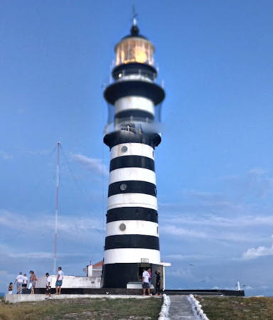
Abrolhos (Ilha de Santa Barbará)
1861. Active; focal plane 60 m (197 ft); white flash every 6 s. 22 m (72 ft) round cast iron tower with lantern and double gallery, painted with narrow black and white horizontal bands; lantern painted black. Original meso-radial Fresnel lens in use. A portion of Luiz Aurore's street view is at right, Wikimedia has Amanda Ercília's photo, another photo is available, Jader Johann has a view from the sea, and Google has a satellite view of the station. The lighthouse was prefabricated in Norwich, England, by the firm of Barnard, Bishop, and Barnard. The lens, installed in 1898, is one of only two meso-radial lenses known to have been produced; these lenses are larger than 1st order but smaller than the great hyper-radial lenses. The listed range of the light is 94 km (59 mi). The lighthouse was originally centered in an octagonal 1-story keeper's house. The Arquipélago de Abrolhos is a group of five rocky islands about 65 km (40 mi) off the south coast of Bahia. Except for the light station the islands are included in the Parque Nacional Marinho de Abrolhos. The light station is staffed by the navy and also provides housing for park rangers and visiting researchers. Located at the highest point of Santa Barbará, the largest island of the group. Site and tower closed; the lighthouse can be seen from many ecotours of the area. . ARLHS BRA-001; BR-1848; Admiralty G0306; NGA 18200.
Ponta Catoeiro
Date unknown. Removed or lost. This was a 16 m (52 ft) square skeletal tower, painted white. No photo available; Bing's satellite viewconfirms the loss of the lighthouse. This light stood on the beaach and either succumbed to beach erosion or was removed to escape it. Located about 1 km (0.6 mi) southwest of the point of the cape, east of Nova Viçosa. Site status unknown. ARLHS BRA-173; ex-BR-1840; ex-Admiralty G0304; NGA List 18204.
* Nova Viçosa
Date unknown. Active; focal plane 64 m (210 ft); white light, 2 s on, 13 s off. 55 m (180 ft) square skeletal microwave retransmission tower painted with red and white horizontal bands. Google has a street view and a satellite view. Located on the Avenida Oceânica in downtown Nova Viçosa. Site open, tower closed. BR-1842; Admiralty G0305; NGA 18206.
Coroa Vermelha
1937. Active; focal plane 16.5 m (53 ft); three white flashes every 15 s. 14 m (46 ft) octagonal cylindrical concrete tower with gallery, painted red. A closeup photo and a 2023 closeup are available, Alexandre Botelho de Mendonça has a 2017 photo, and Google has a satellite view. Located on the Ilha de Coroa Vermelha, an island off the coast near Nova Viçosa. Site status unknown. ARLHS BRA-029; BR-1844; Admiralty G0308; NGA List 18208.
* Mucuri
Date unknown. Active; focal plane 24 m (79 ft); white flash every 6 s. 20 m (66 ft) round cylindrical concrete tower, painted white. Google has a street view and a satellite view. Located in Mucuri, the southernmost city of Bahia. Site open, tower closed. ARLHS BRA-066; BR-1850; Admiralty G0310; NGA List 18210.

Abrolhos Light, Ilha de Santa Barbará, January 2018
Google Maps street view by Luiz Aurore

Information available on lost lighthouses:

Notable faux lighthouses:

Adjoining pages: North: Northeastern Brazil | South: Southeastern Brazil

Return to the Lighthouse Directory index | Ratings key

Posted February 16, 2004. Checked and revised May 31, 2023. Lighthouses: 38. Site copyright 2023 Russ Rowlett and the University of North Carolina at Chapel Hill.