Lighthouses of Brunei

The sultanate of Brunei (officially Brunei Darussalam) is an independent, oil-rich nation facing the South China Sea on the northwestern coast of Borneo. The country's territory consists of two enclaves within the Malaysian state of Sarawak, the larger one on the west side of Brunei Bay and a smaller one on the south side of the bay. The Sultan of Brunei accepted a British protectorate in an 1888 treaty that remained in force until it was dissolved in 1984. No traditional lighthouses were built in Brunei, so all of its lights are of relatively modern origin and design.

In the Malay language used in Brunei the term for a lighthouse is rumah api ("house of fire"); pulau is an island, terumbu is a reef, tanjung is a cape, bukit is a hill, sungai is a river, kuala is the mouth of a river, teluk is a bay, selat is a strait, and pelabuhan is a harbor.

Aids to navigation in Brunei are operated and maintained by the Maritime and Port Authority of Brunei Darussalam (MPABD).

ARLHS numbers are from the ARLHS World List of Lights. Admiralty numbers are from volume F of the Admiralty List of Lights & Fog Signals. U.S. NGA List numbers are from Publication 112.

General Sources
Online List of Lights - Brunei
Photos by various photographers posted by Alexander Trabas. The Brunei photos are by Rainer Arndt.
World of Lighthouses - Brunei
Photos by various photographers available from Lightphotos.net.
Map of Brunei Darussalam
From Worldometers.com.
GPSNavigationCharts
Navigation chart information for Brunei.
Navionics Charts
Navigational chart for Brunei.


Lumut Light, Lumut, April 2018
Google Maps photo by Lovesome


Lighthouses
Ampa Patches (Magpie Rock)
Date unknown. Active; focal plane 17 m (56 ft) four white flashes every 20 s. 17 m (56 ft) square pyramidal steel tower with gallery mounted on a platform supported by three piles. The light is not shown in Bing's satellite view. Located in an oil field area about 30 km (19 mi) offshore and 65 km (40 mi) west of the entrance to Brunei Bay. Accessible only by boat. Site open, tower closed. Admiralty F1934.8; NGA 24248.
Champion Shoals (Champion CP-7)
Date unknown. Active; focal plane about 30 m (98 ft); four white flashes every 10 s. Approx. 25 m (82 ft) skeletal tower. John Quilter has a photo but the light is not seen in Google's satellite view. This is probably the tallest of many lights on oil platforms off the Brunei coast. Located on a large oil platform about 30 km (19 mi) northwest of the entrance to Brunei Bay. Accessible only by boat. Site open, tower closed. Admiralty F9527.5; NGA 24372.
* Lumut
2005. Active; focal plane about 33 m (108 ft); three white flashes every 15 s. 30 m (98 ft) hexagonal tower with lantern and gallery. The tower is painted in red, white, and blue as shown in the photo at the top of this page. Hazwan Yusof has a photo, another photo and a third photo are available, Harry Mason has a nighttime photo, and Google has a good satellite view. Completed in November 2004 and inaugurated in March 2005, this lighthouse guides ships toward Lumut, a port on the South China Sea west of the entrance to Brunei Bay. The light has a listed range of 45 km (28 mi). For reasons unknown the Admiralty includes it on its list of lights on oil and gas production facilities. Located in Lumut. Site open, tower closed. . Admiralty F9527.425.
Pelong Rocks (Pulau Pelong)
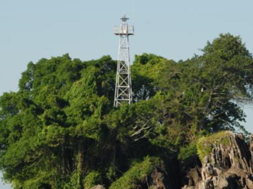
Date unknown. Active; focal plane 24 m (79 ft); three white flashes every 15 s. 11 m (36 ft) square skeletal tower with gallery, painted white. A 2022 photo is at right, Trabas has Arndt's distant view, Lisa Omarali has a photo, but the tower is inconspicuous in Google's satellite view. Located on a rocky islet about 5 km (3 mi) northwest of the entrance to Brunei. Accessible only by boat. Site status unknown. ARLHS BRU-002; Admiralty F1936; NGA 24368.

Pelong Rocks Light, December 2022
Google Maps photo by S N
Muara Entrance Range Front (2)
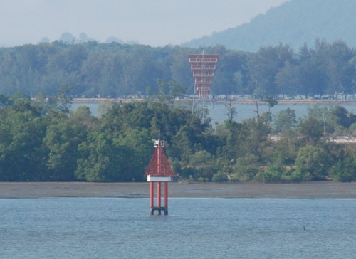
Date unknown. Active; focal plane 15 m (49 ft); continuous green neon light. 15 m (49 ft) skeletal tower mounted on a triangular concrete platform supported by piles. The tower carries a triangular daymark, point up, painted red with a white vertical stripe. James Smith's photo is at right shows the original range, Trabas has Arndt's photo and Bing has a satellite view. The light is now on a new breakwater, as seen in Google's satellite view. The range guides vessels entering Brunei Bay in a dredged channel on the west side of Pulau Muara Besar. Located off the northwestern point of Pulau Muara Besar, an island in the bay entrance. Accessible only by boat. Site open, tower closed. Admiralty F1936.5; NGA 24328.
Muara Entrance Range Rear (2)
Date unknown. Active; focal plane 28 m (92 ft); continuous green neon light. 27 m (89 ft) skeletal tower, painted white. The tower carries a triangular daymark, point down, painted red with a white vertical stripe. This light was relocated about 425 m (1/4 mi) to the north in 2014 after petroleum tanks were built surrounding the old location. Google has a satellite view of the light in its new location. James Smith's photo at right shows the original rear light and Trabas has Arndt's photo. Located near the western end of Pulau Muara Besar. Accessible only by boat. Site status unknown. Admiralty F1936.51; NGA 24332.
#Tanjung Sapo (Sapoh)
Date unknown. Removed but still listed with focal plane 28 m (92 ft); flash every 10 s, white or red depending on direction. Approx. 22 m (72 ft) square skeletal tower. Kevin Lau has a 2020 photo but the tower is not seen in Google's satellite view. The light was dropped from the Admiralty list in October 2019. Located at the east end of Pulau Muara Besar, where it marks the natural entrance to Brunei Bay (the modern entrance is through the dredged channel at the west end of the island). Accessible only by boat. Site status unknown. Admiralty ex-F1938; NGA 24316.

Original Muara Range Lights, Pulau Muara Besar, December 2012
photo copyright James Smith; used by permission
Pulau Chermin (2?) (South Bar Bank Range Rear)
Date unknown. Active; focal plane 16 m (52 ft); two white flashes every 10 s. 16 m (52 ft) aluminum skeletal tower. The tower carries a square red and white daymark. No photo available but Google has an indistinct satellite view. Pulau Chermin is a small island in the entrance to Brunei Harbour. Apparently there was a historic lighthouse on the island, but if so Google's satellite view shows no trace of it. The front light stands on a dangerous reef about 400 m (1/4 mi) northeast of the island. Accessible only by boat. Site open, tower closed. ARLHS BRU-001; Admiralty F1941.1; NGA 24266.

Information available on lost lighthouses:

Notable faux lighthouses:

Adjoining pages: Northeast: Labuan and Sabah | Southwest: Sarawak

Return to the Lighthouse Directory index | Ratings key

Posted March 21, 2006. Checked and revised April 16, 2024. Lighthouses: 8. Site copyright 2024 Russ Rowlett and the University of North Carolina at Chapel Hill.