Lighthouses of Brazil: Paraná and Santa Catarina

The Federative Republic of Brazil (Brasil in Portuguese), the largest country in South America and fifth largest in the world, has a lengthy coastline, a large number of lighthouses, and a distinguished lighthouse history. Colonized by Portugal, Brazil declared its independence in 1822. Uniquely among American nations it was a monarchy as the Empire of Brazil until 1889.

Brazil is a federal republic with 26 states and a federal district. This page covers the lighthouses of Brazil's southern states of Paraná and Santa Catarina This coastline features beautiful sandy beaches framed by steep, sometimes mountainous headlands with a scattering of offshore islands.

The Portuguese word for a lighthouse is farol, plural faróis. In Brazilian use, the word farol generally applies to all light towers, regardless of whether they are enclosed structures or not. The word farolete or farolim is sometimes used for smaller towers. In Portuguese ilha is an island, ilhéu is an islet, cabo is a cape, ponta is a promontory or point of land, rocha is a rock, recife is a reef, baía is a bay, estreito is a strait, rio is a river, and porto is a port or harbor.

Active lighthouses in Brazil are owned by the navy (Marinha do Brasil) and maintained by the Centro de Sinalização Náutica e Reparos Almirante Moraes Rego (CAMR) in the Diretoria de Hidrografia e Navegacão (DHN). Many of the larger lighthouses are staffed by resident keepers or by rotating crews of naval personnel. Only a small number of Brazilian lighthouses are open to the public.

ARLHS numbers are from the ARLHS World List of Lights. BR numbers are from the official Brazilian Lista de Faroís. Admiralty numbers are from volume G of the Admiralty List of Lights & Fog Signals. U.S. NGA numbers are from Publication 110.

General Sources
Faroís Brasileiros
This web site for Brazilian lighthouses has small photos and historical information for many of the major lights.
Online List of Lights - Brazil - South Coast
Photos by various photographers, posted by Alexander Trabas. Most of the photos for this area are by Capt. Peter Mosselberger ("Capt. Peter").
Lighthouses in Brazil
Photos by various photographers available from Wikimedia.
World of Lighthouses - Brazil
Photos by various photographers available from Lighthouses.net.
Lista de faróis do Brasil
Index to articles on the Portuguese Wikipedia.
Leuchttürme Südamerikas auf historischen Postkarten
Historic postcard views posted by Klaus Huelse.
Lista de Faróis
Online version of the official Brazilian light list.
Google Maps
Satellite views of the coast of .Paraná and Santa Catarina.


Ilha do Arvoredo Light, July 2020
Marinha do Brasil photo

Lighthouses of Paraná

Mostly an inland state, Paraná has only a short coastline but its major port Paranaguá, a city of about 150,000 residents, is Brazil's seventh largest port.

Paranaguá Lighthouses
#Paranaguá Range C Rear
1954. Collapsed in 2007. This was a 14 m (46 ft) square concrete tower, formerly painted white with a red horizontal band. The lighthouse was leaning for many years. Alexandre Hartmann has a February 2006 photo and another photo was taken on New Year's Eve 2006. A December 2007 photo, Google's 2014 sea view, Heron Mathoso's 2022 photo, and Google's satellite view show the lighthouse lying on the beach. This light was not replaced because the entrance channel is now on the south side of the Ilha do Mel. Located on the southwestern tip of the Ilha de Peças, where it formerly guided ships around the north side of the Ilha do Mel into the Paranaguá estuary. ex-Admiralty G0526.1
Cassual
1904. Inactive; charted as a landmark. 15 m (49 ft) 4-story square masonry tower with castellated gallery; lantern removed. Lighthouse painted white. A 2026 photo is available, Andre Pimentel has a closeup 2015 photo, and Google has a sea view and a satellite view. Located at the northern end of the Ilha do Mel, across the estuary entrance from the Paranaguá Range C lights. Probably accessible only by boat. Site open, tower closed.
* Ponta das Conchas (Ilha do Mel)
1872. Active; focal plane 67 m (220 ft); white flash every 10 s. 18 m (59 ft) round cast iron tower with lantern and gallery, painted white. Eliandro Piva's 2025 drone view is at right, a 2023 photo is available, Edgar Montelares has a 2021 photo , Wikimedia has several good photos, Robert Wagner has a 2019 photo, Trabas has Capt. Peter's 2006 view from the sea, Silvio Moraes has a street view from the beach, and Google has a sea view, a closeup 2013 street view, and a satellite view. The lighthouse was repainted in 2023. This is one of nine cast iron lighthouses prefabricated for Brazil by P & W McLellan of Glasgow, Scotland. The beautiful Ilha do Mel ("Honey Island"), located in the mouth of the Baía de Paranaguá, is a major tourist attraction easily accessible by ferry from Paranaguá or Pontal do Sul. The island is a state park and most of its interior is an ecological preserve. Located atop a steep headland at the northeastern tip of the Ilha do Mel. Accessible by a hiking trail popular for its spectacular views. Site open, tower closed. . ARLHS BRA-074; BR-3512; Admiralty G0520; NGA 18724.
Caraguatá (Farol das Encantadas)
Date unknown. Active; focal plane 43 m (141 ft); white flash every 6 s. 10 m (33 ft) square cylindrical concrete tower, painted white with one red horizontal band. Laudison Moraes dos Anjos has a closeup photo, Adriano Viana has a 2023 closeup, Trabas has a 2006 photo by Capt. Peter, and Google has a sea view and a satellite view. Located near the southern tip of the Ilha do Mel, marking the east side of the entrance to the channel leading to Paranaguá. Site open but not easy to reach; tower seems to be open. ARLHS BRA-023; BR-3550; Admiralty G0524; NGA 18726.

Ponta das Conchas Light, Ilha do Mel, July 2025
Google Maps photo by Eliandro Piva

Matinhos Lighthouse
Ilha Caiobá
Date unknown. Active; focal plane 27 m (89 ft); white flash every 5 s. 9 m (30 ft) tapered square skeletal tower, painted white. Matheus Servilha has a 2026 photo, Aloisio Jaremtchuk has a photo of the base of the tower, and Google has an indistinct satellite view. Located on the southern tip of an island off a promontory on the south side of Matinhos, marking the entrance to the neighboring city of Guaratuba. The island is connected to the mainland by a gravel bar. Site open, tower closed. ARLHS BRA-122; BR-3692; Admiralty G0538; NGA 18756.

Lighthouses of Santa Catarina

Itapoá and São Francisco do Sul Lighthouses
* Trincheira (Pontal da Barra, Itapoá)
1948. Active; focal plane 9 m (30 ft); red flash every 6 s. 8 m (26 ft) octagonal masonry tower with gallery, painted with red and white horizontal bands. Edi Assis Pereira has a 2021 photo, Walter J. Steppan has a closeup 2016 photo, Milene de Aragão has a closeup 2017 photo, Everson Mincewicz has a closeup street view, and Google has a satellite view. The lighthouse was previously endangered by beach erosion, with stones placed around it for protection; around 2016 a sea wall was constructed and fill was placed to protect the lighthouse. Located on the north side of the Rio São Francisco do Sul estuary in Itapoá, a resort town of about 20,000 residents. Site open, tower closed. . ARLHS BRA-274; BR-3764; Admiralty G0545; NGA 18764.
Sumidouro
Date unknown. Inactive since 2018 and possibly removed. 13 m (43 ft) square pyramidal white fiberglass skeletal tower. No photo available but Google has an indistinct satellite view. Located on the Ilha de São Francisco do Sul, marking the south side of the harbor entrance. Site status unknown. ex-BR-3752; ex-Admiralty G0544; ex-NGA 18763.
Ilha da Paz
1906. Active; focal plane 84 m (276 ft); white light, 3.5 s on, 16.5 s off. 16 m (52 ft) square cylindrical stone tower with lantern and gallery, attached to a 1-story stone keeper's house. The original 4th order F. Barbier & Cie. Fresnel lens, removed in 1989, is on display at the Museu Histórico de São Francisco do Sul. A 2022 photo is at right, a 2022 closeup is available, the Brazilian Navy posted a 2021 photo, Flávio Vilar has a 2018 photo, Portuguese Wikipedia has an article with a distant view, Wikimedia has a 2006 closeup by Dalila Dalprat Sousa Santos, a 2017 view from the sea is available, Huelse has a historic postcard view, and Google has a satellite view. According to a July 2007 article the lighthouse was being restored and would open to the public in 2009 with a museum in the keeper's house; however, it appears that this project was delayed and then suspended in 2012. The lighthouse guards the entrance to the port of São Francisco do Sul, a city of about 55,000 residents. Located on an island about 4 km (2.5 mi) off the coast. Site and tower closed (at least in the past, landing on the island required special permission from the navy). . ARLHS BRA-137; BR-3700; Admiralty G0540; NGA 18760.

Ilha do Paz Light, São Francisco do Sul, March 2022
Instagram photo by Portal São Chico Turismo

Itajaí Area Lighthouses
Itajaí is a city of about 225,000 residents and an important port shipping agricultural products.

*
Ponta do Varrido
Date unknown. Active; focal plane 50 m (164 ft); white flash svery 6 s. 10 m (33 ft) square pyramidal skeletal tower painted white with a black horizontal band. No photo available but Google has a satellite view. Located atop a sharp headland at Penha, about 15 km (9 mi) north of Itajai. Accessible by road. Site apparently open, tower closed. ARLHS BRA-175; BR-3816; Admiralty G0551; NGA 18784.
* Itajaí North Breakwater
1938. Active; focal plane 16 m (52 ft); three red flashes every 10 s. 12 m (39 ft) 3-stage round cylindrical tower, colored with tiles in red and white horizontal bands. The lowest stage appears to covered with small colored tiles. Basilio Rodolfo Protzek has a 2022 photo, Rodrigo Osorio has a photo, Trabas has a 2005 photo by Capt. Peter, Teresa Teixeira has a 2020 closeup, Leonel da Silva has a street view from the south breakwater, and Google has a satellite view. Sometime in 2018-19 the breakwater was shortened and the lighthouse relocated about 140 m (460 ft) northwest. Located at the end of the north breakwater at the mouth of the Rio Itajaí. Accessible by driving on the breakwater. Site open, tower closed. BR-3832; Admiralty G0554; NGA 18800.
** Itajaí South Breakwater
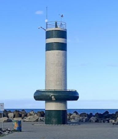
1945. Active; focal plane 16 m (52 ft); green flash every 3 s. 12 m (39 ft) round cylindrical tower, colored with tiles in white with green horizontal bands. The tower also has a public observation deck about 4 m (13 ft) above the base, accessible by an exterior stairway. Wendeel Palheta's 2022 photo is at right, a closeup by Amelie Pouglain is available, Fernanda Platner has a 2018 photo, Everaldo José dos Santos also has a good photo, Trabas has Capt. Peter's 2005 photo, and Google has a satellite view. Located at the end of the south breakwater at the mouth of the Rio Itajaí. Accessible by walking the breakwater. Site open, observation deck open, remainder of tower closed. . BR-3828; Admiralty G0555; NGA 18796.
[Ponta das Cabeçudas]
Date unknown (station established 1902). Active; focal plane 58 m (190 ft); flash every 10 s, two white flashes followed by one red flash. Approx. 6 m (20 ft) post adjoining a square 1-story concrete or masonry equipment building. Lighthouse painted white. A 2020 closeup photo is available, Trabas has Capt. Peter's 2005 photo, and Google has a satellite view. Located at the tip of a narrow peninsula projecting northeastward about 4 km (2.5 mi) southeast of Itajaí. Site status unknown (there is a road to the lighthouse, but it may not be open to the public). ARLHS BRA-121; BR-3868; Admiralty G0552; NGA 18788.

Itajaí South Breakwater Light, Rio Itajaí, August 2022
Google Maps photo by Wendeel Palheta

Ilha de Santa Catarina (Florianópolis Area) Lighthouses
Ilha de Santa Catarina is an island about 54 km (34 mi) long and as much as 18 km (11 mi) wide, connected to the mainland by several bridges. The island is the location of the state capital of Florianópolis and several popular beach resorts.

Ilha da Galé (Pedrada Galé) (2)
Date unknown (station established 1939). Active; focal plane 78 m (256 ft); white flash every 10 s. 10 m (33 ft) square cylindrical concrete tower with gallery, painted with black and white horizontal bands. Trabas has Capt. Peter's 2024 photo, Volfredo Neves has a distant view (1/3 the way down the page) and Bing has an indistinct satellite view. Located atop an island about 10 km (6 mi) east of Canto Grande and the same distance north of the Ilha do Arvoredo. Site status unknown. BR-3872; Admiralty G0558; NGA 18848.
Calhau de São Pedro
Date unknown. Active; focal plane 19 m (62 ft); quick white flash every 3 s. 5 m (17 ft) short mast centered on a square white concrete tower. Trabas has Capt. Peter's 2014 view, Sílvio César Montibeller has a photo, and Bing has an indistinct satellite view. Brazilian sailors use calhau (literally "pebble") to mean a skerry. Located on a rocky reef about 8 km (5 mi) northwest of the northern tip of the Ilha do Arvoredo. Accessible only by boat. Site open, tower closed. BR-3876; Admiralty G0560; NGA 18852.
Ilha do Arvoredo
1883. Active; focal plane 90 m (295 ft); white light with four occultations every 60 s. 16 m (52 ft) round cast iron tower with lantern and gallery, painted with red and white horizontal bands. The original 2nd order Chance Brothers Fresnel lens is in use. Three 1-story keeper's houses. A 2020 Navy photo is at the top of this page, Trabas has Capt. Peter's 2024 photo, Roger Frony posted a 2010 photo on Panoramio, and Google has a satellite view. The lighthouse was prefabricated in England, also by Chance Brothers. In 2020 the Navy repainted the lighthouse and refurbished the rotation device. Along with neighboring islands the Ilha do Arvoredo is included in the Reserva Biológica Marinha do Arvoredo, an ecological reserve. Tours of the reserve are available but it's not clear if these include visits to the lighthouse. Located on an island off the northern end of the Ilha de Santa Catarina. Site and tower closed except possibly for ecotours. ARLHS BRA-042; BR-3880; Admiralty G0562; NGA 18856.

Ilha da Galé Light, Canto Grande, June 2024
photo copyright Capt. Peter Mosselberger; used by permission
* [Ilha Anhatomirim (3?)]
Date unknown (station established 1873). Active; focal plane 39 m (128 ft); red flash every 6 s. 8 m (26 ft) mast with ladder, supported by guy wires, painted white. Fernando Santos has a closeup photo and Google has a satellite view. Anhatomirim is a small island on the west side of the northern entrance to the Canal Santa Catarina, the strait and harbor sheltered by the Ilha de Santa Catarina. The island is occupied by a well-preserved 18th century fortress, the Forteleza de Santa Cruz de Anhatomirim. NGA misspells the name as Anhatomirin. The fort is a popular tourist attraction, accessible by passenger ferry. Located on the highest point of the island. Site open, tower closed. ARLHS BRA-209; BR-3884; Admiralty G0566; NGA 18860.
Ponta da Enseada Cedro
Date unknown. Active; focal plane 8 m (26 ft); green flash every 10 s. 6 m (20 ft) round stone tower painted white. Raimundo Neto has a closeup 2023 photo, Alexsandro Seidler has a 2021 photo, and Google has a satellite view. Located at the base of a headland on the west (mainland) side of the Canal Santa Catarina. May be accessible only by boat. Site open, tower closed. BR-3900; Admiralty G0580; NGA 18880.
Ponta de Galheta (Barra da Lagoa) (2)
Date unknown. Active; focal plane 150 m (492 ft); white flash every 10 s. 10 m (33 ft) round cylindrical white concrete tower. Ivan Tiago Schreiner has a 2023 closeup photo, Trabas has Capt. Peter's 2024 photo, Samuel Batista de Souza has a photo, and Google has a satellite view. Light lists formerly described the original light, a 10 m (33 ft) square skeletal tower. Located on a promontory on the central east coast of the Ilha de Santa Catarina, about 12 km (7.5 mi) due east of Florianópolis. Probably accessible by a hiking trail. Site open, tower closed. ARLHS BRA-170; BR-3883; Admiralty G0562.5; NGA 18857.
Ponta dos Naufragados (Santa Catarina)
1861. Active; focal plane 43 m (141 ft); two white flashes, separated by 3 s, every 15 s. 10 m (33 ft) round concrete tower, painted white. Lantern removed but the watch room with its gallery remains. A 2017 drone view by Daniel Schulz is at right, Trabas has Andreas Köhler's closeup 2009 photo, Zeca Baronio has a 2008 closeup, a 2008 photo is available, Carlos Tuyama has a street view from the base of the lighthouse, and Google has a satellite view. This appears to be the historic lighthouse without its lantern; if so, it deserves much more attention than it has been receiving. Ponta dos Naufragados means "Cape of the Shipwrecked." There's no road access to the site, but the lighthouse can be reached by a hike of about 40 minutes from the nearest road or 20 minutes from the beach below the lighthouse, which is popular with surfers. Andreas Köhler visited this site in early 2009 and reported that the trails are not so easy to follow. Located on a bluff at the southern end of the Ilha de Santa Catarina about 20 miles south of Florianópolis. Site open, tower open, at least at times. ARLHS BRA-077; BR-3908; Admiralty G0584; NGA 18888.
Ilha dos Corais (Ilha de Coral)
Date unknown. Active; focal plane 81 m (266 ft); white flash every 3 s. 12 m (39 ft) round white concrete tower. Trabas has Capt. Peter's 2024 photo and Google has a satellite view. Located on heights at the north end of an island about 5 km (3 mi) offshore and 12 km (7.5 mi) south of Ponta dos Naufragados. Accessible only by boat. Site status unknown. ARLHS BRA-041; BR-3912; Admiralty G0588; NGA 18892.

Ponta das Naufragados Light, January 2017
Google Maps drone view by Daniel Schulz

Southern Santa Catarina Lighthouses
* Imbituba (2)
1918 (station established 1882). Active; focal plane 69 m (226 ft); three white flashes every 15 s. 7 m (23 ft) square pyramidal masonry tower with gallery but no lantern, mounted atop a square 1-story masonry service room. Lighthouse painted white. Trabas has a 2012 photo by Capt. Theo Hinrichs, a 2020 photo is available, Sidnei José Romano has a street view, and Google has a satellite view. The original light was described as an "iron column and house." Located on a bluff on a hook-shaped peninsula sheltering the harbor at Imbituba. Site open, tower closed. ARLHS BRA-055; BR-3924; Admiralty G0592; NGA 18900.
Ilha das Araras
Date unknown (station established 1911). Active; focal plane 54 m (177 ft); two quick white flashes every 6 s. 11 m (36 ft) round concrete tower, painted with red and white horizontal bands. Trabas has a 2024 photo by Capt. Peter and Google has a satellite view. The Ilha das Araras (Island of the Macaws) is a small island about 6 km (4 mi) offshore and 13 km (8 mi) south of Imbituba. Located on the highest point of the island. Accessible only by boat. Site status unknown. ARLHS BRA-040; BR-3936; Admiralty G0594; NGA 18904.
Ilha dos Lobos
Date unknown. Active; focal plane 50 m (164 ft); white flash every 5 s. 6 m (20 ft) round concrete tower, painted white. João Felipe Brito da Silva has a closeup 2022 drone view, Trabas has Capt. Peter's 2024 photo, Helen Viccari has a 2026 view from the sea, and Google has an indistinct satellite view. Located on the highest point of Ilha dos Lobos, a small island about 12 km (7.5 mi) northeast of Laguna. Accessible only by boat. Site status unknown. ARLHS BRA-138; BR-3940; Admiralty G0596; NGA 18908.
**** Santa Marta
1891. Active; focal plane 74 m (243 ft); white light (red sector covers shoals) occulting three times every 30 s. 29 m (95 ft) square stone tower with lantern and gallery rising from a square cluster of 1-story keeper's houses and other light station buildings. Entire lighthouse painted white; roofs of the other buildings are red. The original giant "hyper-radiant" Fresnel lens (larger than 1st order) is still in use; it is one of the world's most powerful lenses and the only one of its kind installed in Latin America. The original clockwork mechanism is still in place although no longer used. A 2021 photo is at right, Wikimedia has Edi Galvani Uliano's 2014 photo, Dieter Heiss has a 2009 photo, Wikimedia has additional photos, Trabas has a distant 2012 view by Capt. Theo Hinrichs, and Google has a 2025 street view and a satellite view. Built by French contractors, this magnificent lighthouse is one of the best known landmarks of the Santa Catarina coast. Located on the Cabo Santa Marta, a prominent headland about 13 km (8 mi) south of the city of Laguna. Site open, lighthouse and tower open for tours during the summer. . ARLHS BRA-032; BR-3956; Admiralty G0600; NGA 18920.
* Araranguá (Morro dos Conventos)
1953. Active; focal plane 85 m (279 ft); three white flashes, separated by 3.3 s, every 20 s. 8 m (26 ft) round concrete tower, painted white with a broad black horizontal band. Thiago Oliveira Veriano has a 2021 photo, José Maciel has a 2007 photo, Caminha da Joinville has a 2008 photo, and Google has a 2017 street view and a satellite view. This light stands on the Morro dos Conventos, a rocky bluff overlooking the beach; this is a popular lookout point. Located at the end of the Rua Atlântica in Araranguá about 80 km (50 mi) southwest of Laguna. Accessible by road; parking provided. Site open, tower closed. ARLHS BRA-007; Admiralty G0602; BR-3960; NGA 18924.
* Mampituba North Mole
Date unknown. Active; focal plane 12 m (39 ft); red flash every 3 s. 10 m (33 ft) round cylindrical concrete tower, painted white. A 2021 closeup photo is available and Google has a street view and a satellite view. Located on the north mole at the entrance to the Rio Mampituba, which separates Santa Catarina and Rio Grande do Sul, in Passo de Torres. Site open, tower closed. BR-3964; Admiralty G0603.

Santa Marta Light, Laguna, April 2021
Instagram photo
by Farol de Santa Marta

Information available on lost lighthouses:

Notable faux lighthouses:

Adjoining pages: North: São Paulo | South: Rio Grande do Sul

Return to the Lighthouse Directory index | Ratings key

Posted January 30, 2004. Checked and revised November 10, 2026. Lighthouses: 24. Site copyright 2026 Russ Rowlett and the University of North Carolina at Chapel Hill.