Lighthouses of Australia: Indian Ocean Territories
| The Australian Indian Ocean Territories is the unit of Australia's federal government responsible for administering two remote island territories, Christmas Island and the Cocos (Keeling) Islands. The territories are former British colonies transferred to Australia in the 1950s. Each territory has its own shire council but they share an administrator, who is appointed by the federal government and based at Christmas Island. The total population of the territories is less than 2500.
Lights in the territories are managed by the Australian
Maritime Safety Authority (AMSA).
Admiralty numbers are from volume
Q of the
Admiralty List of Lights & Fog Signals. U.S. NGA List numbers
are from Publication 112.
- General Sources
- Online List of Lights - Volume Q
- Photos by various photographers posted by Alexander Trabas. There are separate pages for Christmas Island and for the Cocos (Keeling) Islands.
- GPS Nautical Charts
- Navigational charts for Christmas Island and for the Cocos (Keeling) Islands.
|

Smith Point Light, Christmas Island, February 2018
Google Maps street view
|
Christmas Island Lightbeacons
Christmas Island is located about 350 km (220 mi) south of western Java and about 1550 km (960 mi) north northwest of Australia's Northwest Cape. The eroded top of a long-dead volcano, the island was discovered by a British captain in 1615 and got its name when it was rediscovered by a second British captain on Christmas Day 1643. It remained uninhabited until it was annexed by Britain in 1888. It was attached to the Straits Settlements (Singapore) until administration was transferred to Australia in 1958. A large part of the island is now set aside as the Christnas Island National Park. Irregular in shape, the island is very roughly about 16 km (10 mi) in diameter. The population was 1692 at the time of the 2021 census. Christmas Island is accessible by twice-weekly air service from Perth.
- Lightbeacons
- Smith Point
- Date unknown. Active; focal plane unknown; white flash every 3 s. Approx. 10 m (33 ft) square skeletal tower. Google has the 2018 sea view seen above and Google has a fuzzy satellite view. Located on a headland on the north side of the island, partly sheltering the west side of Flying Fish Cove, the island's harbor. Site status unknown. Admiralty Q1691.974.
- * [Flying Fish Cove (Leading)]
- Date unknown. Active; focal plane about 15 m (49 ft); white, red or green light depending on direction, 2 s on, 1 s off. Approx. 8 m (26 ft) metal mast. Google has a street view but the small light is not seen in Google's satellite view. Located beside the road about 100 m (330 ft) west of the island's jetty. Site open, tower closed. Admiralty Q1691.97.
Cocos (Keeling) Islands Lightbeacons
The Cocos (Keeling) Islands -- that's the official name, with the parentheses -- comprise two atolls in the Indian Ocean about 1375 km (885 mi) southwest of Sumatra and 2125 km (1320 mi) northwest of Australia's Northwest Cape. Discovered by the British captain William Keeling in 1609, the islands were uninhabited until the 1820s. In the 1830s the Clunies-Ross family, by then in possession of the islands, began importing Malays to work their copra plantation. Britain formally annexed the islands in 1857, attaching them first to Ceylon (Sri Lanka) and then in 1886 to Straits Settlements (Singapore). Administration was transferred to Australia in 1955 and in 1984 the residents voted for integration with Australia as an external territory. The population, still with a Malay majority, was 593 in the 2021 census. The islands are accessible by twice-weekly air service from Perth.
- Lightbeacons
- [Direction Island]
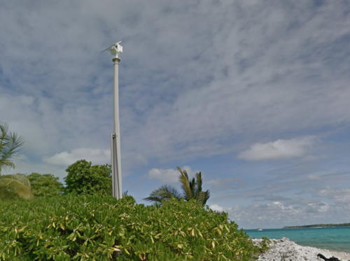
- Date unknown. Active; focal plane 7 m (23 ft); two white flashes every 8 s. 7 m (23 ft) white post. Google has the street view seen at right and a satellite view. Located at the east side of the pass entering the lagoon on the north side of the atoll. Site open, tower closed. Admiralty Q0824; NGA 23080.
- West Island Southeast Point
- Date unknown. Active; focal plane about 40 m (131 ft); flashing or occulting red light. Approx. 37 m (121 ft) skeletal tower. No photo available but Google has an indistinct satellite view. This is probably a communications tower but it's also the closest thing the islands have to a landfall light. Located at the southernmost point of the islands. Site status unknown. Admiralty Q0833.
|
 Direction Island Light, Cocos (Keeling) Islands, February 2018
Google Maps street view |
Information available on lost lighthouses:
Notable faux lighthouses:
Adjoining pages: Southeast: North Western Australia
Return to the Lighthouse Directory index
| Ratings key
Posted November 2, 2021. Checked and revised April 9, 2025. Lighthouses: 2. Site copyright 2025
Russ Rowlett and the University of North Carolina at Chapel Hill.

