Lighthouses of Australia: North Western Australia

The independent Commonwealth of Australia occupies the entire Australian continent, the island of Tasmania, and numerous smaller islands. British exploration and settling of the continent began late in the 1700s, with the first colony established in the Sydney area in 1788. By the 1850s there were six British colonies, including New South Wales and Queensland in the east, Victoria and South Australia in the south, Western Australia in the west, and Tasmania off the south coast. The Commonwealth was formed on New Years Day 1901 as a federation of the six colonies. Australia is both the smallest continent and the sixth-largest country in the world, with a population of about 26 million.

The state of Western Australia includes all of the continent west of longitude 129° East. It is by far the largest state in the Australian union, including roughly one third of the country and about the same fraction of the coastline. The coast sweeps in a great semicircle, facing south on the Southern Ocean, west and northwest on the Indian Ocean, and north on the Timor Sea. A large part of the coastline is wild and thinly populated and there are some very large gaps between lighthouses.

Because of the large area of the state two pages are required in the Directory. This page includes lighthouses of the northern half of the coast: the Gascoyne, Pilbara, and Kimberley regions. A second page covers South Western Australia.

The coastal Western Australia lighthouses are managed by the Australian Maritime Safety Authority (AMSA), but after automation a number of the light station properties were transferred to the control of the state Parks and Wildlife Service.

ARLHS numbers are from the ARLHS World List of Lights. Admiralty numbers are from volume Q of the Admiralty List of Lights & Fog Signals. U.S. NGA numbers are from Publication 111.

General Sources
Lighthouses of Western Australia
The section of the Lighthouses of Australia site devoted to Western Australia lights.
AMSA Heritage Lighthouses
An interactive map links to information and photos for the major AMSA lighthouses.
Seaside Lights - Western Australia
Photos and notes by Garry Searle.
Lighthouses and Lightvessels in Australia - Western Australia
Index to Wikipedia articles; many include photos.
World of Lighthouses - Western Australia
Photos by various photographers available from Lightphotos.net.
Online List of Lights - Australia
Photos by various photographers posted by Alexander Trabas.
Leuchttürme Australiens, Neuseelands und Ozeaniens auf historischen Postkarten
Historic postcard images posted by Klaus Huelse.
GPSNauticalCharts
Navigational chart for Western Australia.
Navionics Charts
Navigational chart for Western Australia.


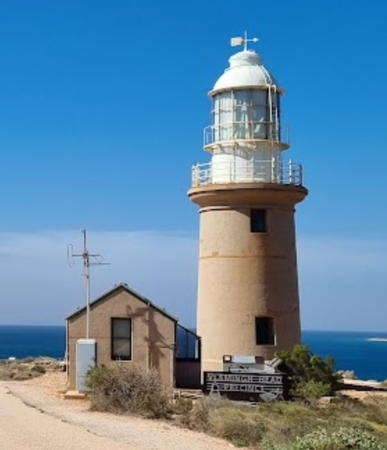
Vlaming Head Light, Exmouth, April 2023
Google Maps photo by Bruach Colliton
Gascoyne Region Lighthouses

The Gascoyne Region occupies the northwestern corner of the Australian continent. It is a very dry, thinly populated region; the total population is less than 10,000. The region is named for the Gascoyne River, which flows into the Indian Ocean at Carnarvon.

Shire of Shark Bay Lighthouses
Shark Bay is a large, mostly shallow inlet of the Indian Ocean behind Dirk Hartog Island and the Bernier and Dorre Islands. Known for its exceptional natural features and great diversity of species it is recognized as a UNESCO World Heritage Site. The surrounding Shire of Shark Bay has a population of less than 1000.
Steep Point (2)
1984 (station established 1960). Active; focal plane 70 m (230 ft); white flash every 10 s. 4 m (13 ft) round white fiberglass tower. A photo is available and Google has an indistinct satellite view. The light marks the westernmost point of the Australian mainland, guiding vessels through a narrow passage at the south end of Dirk Hartog Island. The original lighthouse was a 4 m (13 ft) cast iron tower with lantern and gallery. Located atop a vertical cliff at the point of the cape. Site open, tower closed. ARLHS AUS-304; Admiralty Q1728; NGA 9208.
Cape Inscription
1910. Active; focal plane 39 m (127 ft); three white flashes every 15 s. 15 m (49 ft) round concrete block tower with lantern and gallery. Tower is unpainted, lantern painted white. This is Australia's westernmost lighthouse, standing in longtitude 112°58.0' E. Prue Brinkley's photo is at right, a 2023 photo is available, another closeup photo is available, Lighthouses of Australia's page has several historic photos from AMSA, and Google has a satellite view. The keeper's houses and other station buildings have been restored in a decade-long effort that earned a UNESCO Asia-Pacific Cultural Heritage Conservation award in September 2014. The lighthouse is located on Dirk Hartog Island, a long island sheltering Shark Bay. The island, long privately owned, is now incorporated in the Shark Bay Marine Park. The one accommodation on the island is at least 50 km (30 mi) to the south. It is possible to reach the site by 4WD vehicle, but this would require a substantial expedition. Located at the northernmost point of the island, marking the entrance to Shark Bay. Site open, tower closed. Operator: AMSA. Site manager: Dept. of Parks and Wildlife (Shark Bay Marine Park). . ARLHS AUS-032; Admiralty Q1724; NGA 9212.
* Cape Peron
1980s (?). Active; focal plane 57 m (187 ft); white flash every 5 s. Approx. 20 m (66 ft) slender round cylindrical tower, painted white. A photo and a distant view are available and Google has a street view and a satellite view. Cape Peron is the northern tip of the Peron Peninsula, which is connected tenuously to the mainland east of Dirk Hartog Island. The northern portion of the peninsula is set aside as François Peron National Park. Cape and park are named for the French naturalist François Peron, who studied the area in the early 1800s. Located on the point of the cape. Accessible by 4WD vehicles (guided tours are available and recommended). Site open, tower closed. Admiralty Q1726; NGA 9228.

Cape Inscription Light, Dirk Hartog Island, September 2021
Google Maps photo by Prue Brinkley
 

Shire of Carnarvon Lighthouses
The largest town of the Gascoyne with a population about 4500, Carnarvon is located at the mouth of the Gascoyne River. The town is known as a tourism center and fishing port. In the early days of the Space Age (1963-75) Carnarvon gained some international attention as the site of an important U.S. NASA tracking station.
[Cape St. Cricq]
1971. Active; focal plane 44 m (144 ft); white flash every 2.5 s. 2 m (7 ft) white fiberglass cabinet. No photo available but Google has a distant satellite view. Cape St. Cricq is the southern tip of Dorre Island, one of two long, narrow islands at the northern edge of Shark Bay. Located on a steep bluff near the point, opposite Cape Inscription on Dirk Hartog Island. Site and tower closed. Site manager: Dept. of Parks and Wildlife (Bernier and Dorre Island Nature Reserve). Admiralty Q1723; NGA 9216.
** Babbage Island (1)
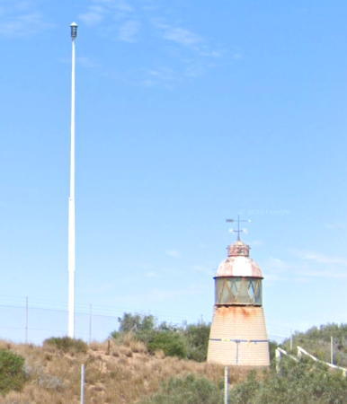
1896. Inactive since 1961. Approx. 6 m (20 ft) round tower with lantern. Lantern dome painted with red and white vertical stripes. Annie Street has a 2019 photo, Derek Graham has a closeup photo, Lightphotos.net has Andreas Köhler's 2007 photo, and Google has the 2022 street view seen at right and a satellite view. The lantern was originally mounted on an 18 m (60 ft) wood frame skeletal tower, which was damaged by fire in 1909 and again in 1961. The light was then moved to the square steel skeletal tower seen in Köhler's photo. The 1-story keeper's house houses the Lighthouse Keeper's Cottage Museum. Located at Pelican Point, the northwestern tip of Babbage Island, on the northwest side of Carnarvon. Site open, Lighthouse Cottage Museum open daily 2-4 pm, tower closed. Owner/site manager: Carnarvon Heritage Group. ARLHS AUS-275.
* [Babbage Island (3)]
2019(?). Active; focal plane 30 m (98 ft); flash every 5 s, white or red depending on direction. 18 m (60 ft) white steel mast. Google has the 2022 street view seen at right and a satellite view. This light replaced the 1962 light, a square steel skeletal tower with gallery and the light atop a short fiberglass tower. Lightphotos.net has Andreas Köhler's photo and Ando Orth has a photo. In October 2015 the Department of Transport proposed to deactivate the light; instead it replaced by the mast. Located at Pelican Point, the northwestern tip of Babbage Island, on the northwest side of Carnarvon. Site open, Lighthouse Cottage Museum open daily 2-4 pm, tower closed. Operator: AMSA (?). Site manager: Carnarvon Heritage Group. ARLHS AUS-276; Admiralty Q1718; NGA 9252.
[Cape Ronsard (Bernier Island) (2)]
1985 (station established 1961). Active; focal plane 22 m (72 ft); two white flashes every 8 s. 3.5 m (12 ft) white fiberglass tower. No photo of the present light is available but Google has a satellite view. The original lighthouse was a 7 m (23 ft) round cylindrical steel tower with lantern. Bernier Island is a long, sandy ridge about 30 km (19 mi) west of Carnarvon. The light is at the northern tip of the island. Accessible only by boat. Site status unknown. Operator: AMSA. Site manager: Dept. of Parks and Wildlife (Bernier and Dorre Island Reserve). Admiralty Q1717; NGA 9264.

Old and new Babbage Island Lights, Carnarvon, August 2022
Google Maps street view
* Point Quobba
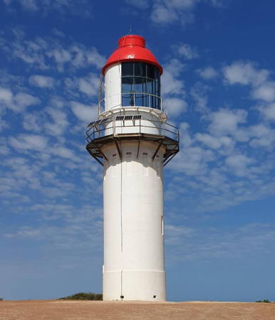
1950. Active; focal plane 64 m (210 ft); four white flashes every 20 s. 18.5 m (61 ft) round cylindrical concrete tower with lantern and gallery, painted white; the dome of the lantern is red. George Rosler's photo is at right, Marek Migurski has another closeup photo, Trabas also has a photo, Lighthouses of Australia's page has several of Searle's photos, and Google has a satellite view and a very distant street view. The lantern was relocated here from Cape Wickham Light in Bass Strait, Tasmania. Point Quobba is famous for spectacular blowholes on the rocky beach; the lighthouse gets less attention. Located about 500 m (0.3 mi) south of Blowholes Road and 1.2 km (3/4 mi) from the beach, about 80 km (50 mi) north of Carnarvon by road. Accessible by road (4WD recommended). Site open but fenced, tower closed. Operator/site manager: AMSA. . ARLHS AUS-215; Admiralty Q1716; NGA 9268.

Shire of Exmouth (North West Cape Area) Lighthouses
Exmouth is a town of about 2500 residents established in 1967 to support the nearby naval communications station. It has become an important center of tourism at Australia's northwestern tip.

Point Cloates (1)
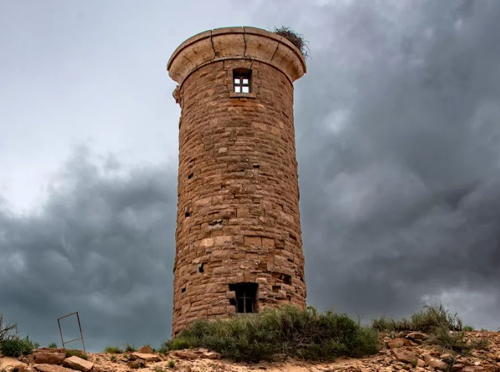
1910. Inactive since 1932. Approx. 12 m (40 ft) round sandstone tower; lantern removed. 1-story keeper's house in ruins. Alan Neander's photo is below right, Mark Dixon has a closeup photo, another closeup photo of the lighthouse is available, Exploroz.com has photos, and Google has a distant satellite view. Wikipedia has a National Archives photo dated 1917. This lighthouse was abandoned after it was heavily damaged by an earthquake. It was replaced in 1936 by a skeletal tower on Fraser Island, but that light was swept away by a storm in 1966. The light was returned to the mainland in a 3.5 m (12 ft) round white fiberglass cabinet (focal plane 39 m (128 ft); two white flashes every 15 s) about 1 km (0.6 mi) from the ruined lighthouse. Mark Dixon has a photo of the new light and Google has a distant satellite view. The historic tower has conspicuous cracks from the earthquake but it has stood for more than 85 years and does not seem to be in danger of falling. In 2005 the lighthouse was added to the state register of historic places. Facing the Indian Ocean, Point Cloates is a remote location at the base of the Northwest Cape peninsula; it is within the 50,000 hectare (193 square mile) reserve formerly under pastoral lease as Ningaloo Station. Following a long legal dispute, the area will now be managed by Parks and Wildlife and the indigenous Gnulli people. There is a helipad at the lighthouse, and it is possible to reach the site by 4WD from Exmouth. Site open, tower closed. Owner: unknown. . ARLHS AUS-131. Current light: Admiralty Q1714; NGA 9272.

Point Quobba Light, MacLeod, August 2019
Google Maps photo
by George Rosler
* Vlaming (Vlamingh) Head
1912. Inactive since 1967. 10 m (33 ft) round concrete tower with lantern and gallery. Tower unpainted, lantern painted white. Oil house. The keeper's houses are leased to the Ningaloo Lighthouse Holiday Park and are available for overnight accommodations. Bruach Colliton's 2023 photo is at the top of this page, René Brask has a closeup photo, Keith Collicoat also has a great closeup, and Google has a street view and a satellite view. This lighthouse was built to mark North West Cape, the northwestern corner of the Australian continent. The light was moved in 1967 to one of the tall skeletal towers of the nearby Naval Communications Centre. After being damaged by Cyclone Vance in 1999 the lighthouse was restored in 2000-2001 with the help of numerous volunteers and a federal cyclone repair grant. Ken Baker, of the former Commonwealth Lighthouse Service, succeeded in putting the light back in operable condition, making this the only working kerosene-fueled lighthouse in Australia. The light is lit only on a few special occasions. Note: although the cape is named for the Dutch explorer Willem de Vlamingh, the spelling Vlaming is customary for the lighthouse. Located 15 km (9 mi) north of Exmouth and about 10 km (6 mi) west southwest of the point of North West Cape (the northwestern corner of Australia). Accessible by road. Site open, tower closed. Owner/site manager: Shire of Exmouth. . ARLHS AUS-165.
North West Cape
1967. Active; focal plane 129 m (423 ft); white flash every 3 s. 358 m (1174 ft) slender steel skeletal communications tower. Trabas has Jim Smith's photo and Google has a satellite view. This tower is at the northwestern corner of a huge hexagonal array of naval communications towers. Located about 5 km (3 mi) east of the Vlaming Head lighthouse (previous entry). Site and tower closed. Owner: U.S. Navy. Site manager: Naval Communications Centre Harold E. Holt. Admiralty Q1710; NGA 9276.

Point Cloates Light, Ningaloo Station, May 2022
Instagram photo by Alan Neander

Pilbara Region Lighthouses

The Pilbara includes a vast region of northwestern Australia. In general it is very dry or desert, although the summer monsoon and tropical cyclones sometimes bring rain. Its coastline faces northwest on the Indian Ocean.

Shire of Ashburton Lighthouses
The Shire of Ashburton occupies a mostly inland region of the western Pilbara. Its one coastal settlement is the town of Onslow, a small port and tourism center with a population of about 850.
Bessieres Island (Bessiers Island, Anchor Island) (3)
1992 (station established 1913). Active; focal plane 27 m (89 ft); three white flashes every 12 s. 4 m (13 ft) white fiberglass tower. A photo is at right and Bing has a satellite view. The original lighthouse, a 17 m (56 ft) skeletal tower, was demolished in 1982. Bessieres Island is one of a scattering of small islands obstructing the entrance to Exmouth Gulf. Located on the highest point of the island about 75 km (45 mi) northeast of Exmouth. Accessible only by boat. Site and tower closed. Operator/site manager: AMSA. Admiralty Q1702; NGA 9284.
#Onslow
Date unknown. Apparently removed; listed with focal plane 25 m (82 ft); white flash every 2 s. 18 m (59 ft) square skeletal tower with gallery, painted white. Google has a distant 2008 street view. This light has been dropped from the Admiralty list. Although Navionics charts it as active it is not seen in Bing's satellite view. Founded for the exporting of wool, Onslow has become the leading tourist town of the Pilbara. Located at Second Avenue and Watson Drive on the southeast side of Onslow. Site open, tower closed. Operator/site manager: AMSA. ex-Admiralty Q1704.1; NGA 9296.
Airlie Island (2)
1980 (station established 1913). Active; focal plane 26 m (85 ft); four white flashes, separated by 2 s, every 16 s. 21 m (69 ft) tapered steel skeletal tower with lantern and gallery. Lantern painted white. Steve Swayne has a distant 1988 photo and Bing has a satellite view. Airlie Island is in an oil and gas producing area and large tankers anchor offshore. The island itself is a nature reserve. Located on the north side of the island about 27 km (17 mi) north of Onslow. Accessible only by boat. Site and tower closed. Operator/site manager: AMSA. ARLHS AUS-241; Admiralty Q1698; NGA 9304.

Bessieres Island Light, Exmouth Gulf, July 2005
ex-Panoramio Creative Commons photo
by Terra'Mer

City of Karratha (formerly Shire of Roebourne) Lighthouses
The Shire of Roeburne was renamed the City of Karratha in 2014. The extended city has a population of about 22,000. Karratha's port at Dampier is a major industrial facility shipping iron ore, salt, and natural gas.

[Mary Anne Reef (Mary Anne Island) (8?)]
2008 (station established 1933). Active; focal plane 8 m (26 ft); white flash every 5 s. 4 m (13 ft) white fiberglass tower. Google has a satellite view. Lights have been replaced repeatedly at this exposed and dynamic location. Located on a reef about 15 km (9 mi) off the coast and 50 km (30 mi) northeast of Onslow. Accessible only by boat. Site status unknown. Operator/site manager: AMSA. Admiralty Q1696; NGA 9308.
Great Sandy Island (2)
1986 (station established 1959). Active; focal plane 17 m (56 ft); three white flashes every 12 s. 4 m (13 ft) white fiberglass tower. No photo of the current light available but Google has a satellite view. NGA lists the height as 2 m (7 ft) This describes the original light, which was relocated to the Cape Naturaliste Lighthouse Museum (see the South Western Australia page). The current light is a "size 3 GRP tower" like the Steep Point and Bessieres Island Lights. Located on the southwest end of the narrow island, about 75 km (45 mi) northeast of Onslow. Admiralty Q1695; NGA 9312.
North Sandy Island (2)
1980 (station established 1913). Active; focal plane 26 m (85 ft); two white flashes, separated by 2 s, every 8 s. 20 m (66 ft) tapered steel skeletal tower with lantern and gallery. Lantern painted white. No recent photo available but Bing has a satellite view. Located on an island about 90 km (60 mi) northeast of Onslow. Site and tower closed. Accessible only by boat. Operator/site manager: AMSA. ARLHS AUS-237; Admiralty Q1694; NGA 9316.
North West Island
1968. Active; focal plane 17 m (56 ft); white flash every 5 s. 5 m (17 ft) white fiberglass tower. No photo of the current light available but Bing has an indistinct satellite view. This light is probably similar to the Bessieres Island Light. Located on the highest point of North West Island, the northernmost of the Montebello Islands. Accessible only by boat. Operator: AMSA. Site manager: Dept. of Parks and Wildlife (Montebello Islands Marine Park). Admiralty Q1691.98; NGA 9328.
[Trimouille Island]
Date unknown. Active; focal plane 39 m (128 ft); three white flashes every 15 s. 2 m (7 ft) white fiberglass cabinet. No photo available but Google has a satellite view. Tremouille Island was the site of three British nuclear bomb tests in the mid 1950s. The island is now considered to be only slightly radioactive but visitors are warned not to disturb the soil or remove artifacts. Located on an island about 10 km (6 mi) southeast of North West Island. Accessible only by boat. Operator: AMSA. Site manager: Dept. of Parks and Wildlife (Montebello Islands Marine Park). Admiralty Q1691.99; NGA 9332.
* Dampier Port Control Tower
Date unknown. Inactive. Lantern centered on an octagonal building, part of the port authority's headquarters. No photo available but Google has a satellite view. Dampier is a modern industrial port northwest of Karratha. Located on East Intercourse Island, one of several islands connected to shore by causeways as part of the port development. Site open, tower status unknown. Owner/site manager: Pilbara Ports Authority. ex-Admiralty Q1691.77; ex-NGA 9341.5.
Legendre Island (Cape Legendre) (4)
1989 (station established 1927). Active; focal plane 33 m (108 ft); two white flashes every 10 s. 4 m (13 ft) white fiberglass tower. No photo of the present light is available but Google has a satellite view. The original lighthouse was a 12 m (40 ft) skeletal tower; the 1963 light was a round lantern with a Fresnel lens. The light was replaced twice in 1989, because the first replacement was destroyed almost immediately by a tropical cyclone. Legendre Island is the northernmost island of the Dampier archipelago, and the light serves as a landfall light for Port Dampier. Located at the western tip of the island, known as Cape Dampier. Accessible only by boat. Site status unknown. Operator/site manager: AMSA. Admiralty Q1690; NGA 9344.
** Jarman Island
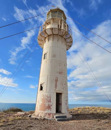
1888. Inactive since 1987. 15.5 m (51 ft) round cast iron tower with lantern and gallery. Lower half of the tower painted red, upper half and lantern white. Guy wires are attached to the tower but appear to provide little support. The original 2nd order Fresnel lens is on display at Cape Naturaliste Light on the Southwest Coast (see the South Western Australia page). 1-story keeper's house in ruins. A 2021 photo is at right, Ngurrangga Tours has a 2019 photo, Anthony Dunn has a 2021 view from the mainland, and Google has a satellite view. This tower was prefabricated in Birmingham, England. Originally the lighthouse was painted with the upper half white and lower half red, as seen in the photo on Lighthouse of Aistralia's page. This undated photo has been frequently reposted, including on Instagram and Google Maps. The lighthouse was endangered for many years by rust and abandonment, but in 2003 the Australian government granted $75,000 to begin restoration of the lighthouse as a tourist attraction. Additional funding was sought from the Western Australia Lotteries Commission. By 2005 the restoration of the tower was complete. Clearly the lighthouse is endangered again. In 2020 the state of Western Australia was looking for an ecotourism developer to purchase the entire Cossack area including the lighthouse. Located on an island 3 km (2 mi) southeast of Point Samson and about 3 km (2 mi) northeast of Cossack, a historic port and pearling center. Accessible only by boat. Site open, guided tours available from Cossack, tower closed. Owner/site manager: City of Karratha. . ARLHS AUS-278.

Jarman Island Light, Cossack, October 2021
Frame from Instagram video by outbackbrats

Town of Port Hedland Lighthouses
Port Hedland is a major port exporting iron ore from Pilbara mines; it ships the highest tonnage of any Australian port. The approach to the port is by a narrow curving channel requiring many navigational lights. These lights are maintained by the Pilbara Ports Authority.
Airey Range Front
Date unknown. Active; focal plane 40 m (131 ft); continuous red light. Approx. 38 m (125 ft) tapered square skeletal tower. No photo available but Google has a satellite view. This is the final approach range for vessels entering Port Hedland Harbour. The tower also carries the rear light of the Utah Range for ships leaving the town waterfront. Located on Utah Point in the iron ore shipping area on Finucane Island opposite the town waterfront. Site and tower closed. Admiralty Q1681.9; NGA 9396.
Airey/Leslie Range Common Rear
Date unknown. Active; focal plane 44 m (144 ft); continuous red light. Approx. 38 m (125 ft) tapered triangular skeletal tower. No photo available but Google has a satellite view. Located about 200 m (650 ft) southwest of the front light. Site and tower closed. Admiralty Q1682; NGA 9400.
Leslie Range Front
Date unknown. Active; focal plane 37 m (121 ft); continuous red light. Approx. 36 m (118 ft) tapered square skeletal tower. No photo available but Google has a satellite view. The range guides leaving the town waterfront. Located 143 m (470 ft) southeast of the common rear light. Site and tower closed. Admiralty Q1681.99; NGA 9404.
Goldsworthy Range Rear
Date unknown. Active; focal plane 27 m (89 ft) (?); continuous blue light. Approx. 14 m (46 ft) roubust post, painted red and carrying a slatted daymark, with a stairway zigzaging up the tower. Google has the street view shown at right and an indistinct satellite view. The range guides vessels approaching Port Hedland Harbour. Located near the intersection of Moore and Taplin Streets in Port Hedland. Site and tower closed but the tower can be seen from nearby streets. Admiralty Q1679.98; NGA 9392.
Bedout Island (2)
1980 (station established 1909). Active; focal plane 24 m (79 ft); three white flashes every 15 s. 17.5 m (57 ft) stainless steel skeletal tower, painted white. There is a round metal equipment shelter under the base of the tower. No photo available but Bing has a satellite view. The lantern from the original lighthouse was refurbished and placed on the Hillarys Boat Harbor lighthouse near Perth (see the South Western Australia page). Located on an island about 50 km (30 mi) off the coast and about 125 km (80 mi) northeast of Port Hedland. Accessible only by boat. Site open, tower closed. Operator: AMSA. ARLHS AUS-293; Admiralty Q1675; NGA 9416.

Goldsworthy Range Rear Light, Port Hedland, November 2018
Google Maps street view

Kimberley Region Lighthouses

The Kimberley is a large region in the northeastern corner of Western Australia; it has about 50,000 residents. Broome, Derby and Wyndham are the major coastal towns in the region.

Shire of Broome Lighthouses
Imperieuse Reef (2)
1970 (station established 1960). Active; focal plane 30 m (100 ft); white flash every 5 s. 30 m (98 ft) round cylindrical stainless steel tower with gallery but no lantern. Taller sibling of the somewhat better-known Pelsaert Island Light (see the South Western Australia page). A photo is available and Bing has a satellite view. Located on the reef, the southernmost of the three coral reefs known as the Rowley Shoals, about 260 km (160 mi) west of Broome. Accessible only by boat; cruises to the reefs are available from Broome. Site open, tower closed. Operator: AMSA. Site manager: Dept. of Parks and Wildlife (Rowley Shoals Marine Park). ARLHS AUS-094; Admiralty Q1674; NGA 9424.
* Gantheaume Point (Broome) (3)
1984 (station established 1905). Active; focal plane 33 m (108 ft); two white flashes, separated by 3 s, every 10 s. 23 m (75 ft) tapered square steel skeletal tower with lantern and gallery. Lantern painted white. Keeper's houses demolished. Clark Greenaway's 2023 photo is at right, Trabas has Jim Smith's photo, Lucy Del Casale has a 2021 photo, David Rowley has a street view showing the lighthouse in action, and Google has a 2018 street view and a satellite view. The original lighthouse was replaced in 1917. This is the landfall light for Broome, a pearling and resort town with a population of about 14,000. The station is surrounded by interesting red rock formations. Located on the point, a prominent cape just southwest of Broome. Site open (but fenced), tower closed. Operator/site manager: AMSA. . ARLHS AUS-212; Admiralty Q1660; NGA 9428.
Red Bluff (2)
1987 (station established 1968). Active; focal plane 48 m (157 ft); two white flashes every 15 s. 4 m (13 ft) white fiberglass tower. No photo available but Google has a satellite view. The original light was deactivated and removed in 1981; the station was inactive until 1987. Located atop a steep bluff on the mainland opposite East Island. There is road access to the light. Site probably open, tower closed. Admiralty Q1659; NGA 9447.
East Island (2)
1984 (station established 1968). Active; focal plane 25 m (82 ft); white flash every 2 s. 19 m (62 ft) skeletal tower, painted white. No photo available but Google has a satellite view. Located on a tiny island in the Lacepede Islands, at the southeastern end of a coral reef about 120 km (75 mi) north of Broome. Accessible only by boat. Site status unknown. Admiralty Q1658; NGA 9448.

Gantheaume Point Light, Broome, September 2023
Google Maps photo
by Clark Greenaway
* Cape Leveque
1912. Active; focal plane 43 m (142 ft); three white flashes every 20 s. 13 m (43 ft) round steel (?) tower with lantern and gallery, painted white. Keeper's houses demolished. The original 3rd order Fresnel lens is on display at the Western Australia Maritime Museum in Fremantle. A photo by Alan Ventress is at right, Wikipedia's article has a 2006 photo by Bruce Mitchell, Mark Dixon has a 2011 photo, a closeup photo is available, Trabas has a commercial photo, and Google has a satellite view. Located at the northern tip of the Dampier Peninsula about 240 km (150 mi) north of Broome. It is possible to drive to the cape on the Cape Leveque Road but most visitors arrive by air. The lighthouse is close to the rustic accommodations of the former Kooljaman Resort, which unfortunately closed in November 2021. Site open (but fenced), tower closed. Operator: AMSA. Site manager: Bardi Jawi Aboriginal Communities. . ARLHS AUS-036; Admiralty Q1650; NGA 9452.

Shire of Derby-West Kimberley Lighthouses
* Derby Range Rear
Date unknown. Active; focal plane 24 m (79 ft); white light, 2 s on, 2 s off. Approx. 23 m (75 ft) square pyramidal skeletal tower carrying a triangular daymark, point down. Google has a street view and a satellite view. Google also has a street view of the front light mounted on a tall steel mast. This is the approach range for the wharf at Derby, a town of about 3300 and a minor port shipping lead and zinc. Derby is on King Sound, a bay known for its tides, the highest in Australia and among the highest in the world. Located on Rowan Street southeast of the waterfront. Site open, tower closed. Admiralty Q1656.1; NGA 9464.
Caffarelli Island
1967. Active; focal plane 130 m (428 ft); white flash every 10 s. 6 m (21 ft) round cylindrical steel tower with lantern, painted white. Lighthouses of Australia has Winsome Bonham's aerial photo and Google has a distant satellite view. Located on a high island in the Buccaneer Archipelago, a group of more than 1000 rugged islands north of Derby. Accessible only by boat. Site status unknown. Operator/site manager: AMSA. ARLHS AUS-251; Admiralty Q1646; NGA 9468.
Tanner Island (More Island)
1951. Active; focal plane 23 m (77 ft); two white flashes every 10 s. 6 m (20 ft) square cylindrical concrete tower with lantern and gallery, painted white. Vladimir Knyaz has a view from the sea (also seen below right) as well as a more distant view, and Google has a satellite view. Located on another island of the Buccaneer Archipelago, about 25 km (15 mi) east of Caffarelli Island. Accessible only by boat. Site status unknown. Operator/site manager: AMSA. ARLHS AUS-240; Admiralty Q1643; NGA 9472.

Cape Leveque Light, Dampier Peninsula, August 2019
Google Maps photo
by Alan Ventress
Adele Island (3)
2004(?) (station established 1951). Active; focal plane 31 m (101 ft); white flash every 5 s. 30 m (98 ft) square steel skeletal tower, lower half pyramidal and upper half cylindrical. A distant view from the sea is available and Google has a satellite view. Located at the northeastern tip of an island at the southern end of a reef system about 250 km (155 mi) north of Derby. Accessible only by boat. Site status unknown. Operator/site manager: AMSA. ARLHS AUS-001; Admiralty Q1640; NGA 9500.

Shire of Wyndham-East Kimberley Lighthouses
Browse Island (3)
Around 2020? (station established 1945). Active; focal plane 35 m (115 ft) (?); two white flashes every 6 s. Approx. 11 m (36 ft) octagonal cylindrical white concrete tower. No photo available but Google has an indistinct satellite view. The second (1958) lighthouse was a 32 m (105 ft) square skeletal tower; it seems that the focal plane of the new light should be lower. Amateur radio operators posted a 2017 aerial view of the 1958 lighthouse (near the bottom of the page). Located far out in the Timor Sea, about 275 km (175 mi) northeast of Derby. Accessible only by boat. Site status unknown. Operator/site manager: AMSA. ARLHS AUS-308; Admiralty Q1642; NGA 9504.
Degerando Island
1960. Active; focal plane 37 m (121 ft); four white flashes every 20 s. 6 m (20 ft) round tower with lantern, painted white. No photo available but Google has a satellite view. Located on a small island at the northern entrance to Collier Bay, a very remote area. Accessible only by boat. Site status unknown. Operator/site manager: AMSA. ARLHS AUS-296; Admiralty Q1641; NGA 9508.
Lesueur (Leseur) Island
1963. Active; focal plane 20 m (66 ft); four white flashes every 16 s. 20 m (66 ft) square skeletal tower with lantern and gallery, painted white. No photo available but Bing has a satellite view. Lesueur Island is a small island about 30 km (20 mi) east of Cape Londonderry, the western entrance to Joseph Bonaparte Gulf. Located at the west end of the island. Accessible only by boat. Operator/site manager: AMSA. Admiralty Q1638; NGA 9512.
Lacrosse Island
1961. Active; focal plane 113 m (370 ft); white flash every 7.5 s. 6 m (20 ft) cylindrical steel tower, painted white. No lantern. No photo available but Google has a satellite view. Located on an island in the mouth of Cambridge Gulf about 80 km (50 mi) northeast of Wyndham. Accessible only by boat. Site status unknown. Operator/site manager: AMSA. ARLHS AUS-097; Admiralty Q1636; NGA 9516.

Tanner Island Light, Buccaneer Archipelago, July 2016
ex-Google Plus photo
by Vladimir Knyaz
Laffan Point Range Front
Date unknown. Active; focal plane 6 m (20 ft); white light, 2 s on, 2 s off. 6 m (20 ft) white tower, form unknown. No photo available but Google has an indistinct satellite view. This is one of several ranges guiding vessels on the approach to Wyndham, the northernmost town in Western Australia. Located on a point on the west side of the West Arm of Cambrudge Gulf. Accessible only by boat. Site status unknown. Admiralty Q1636.73.
Laffan Point Range Rear
Date unknown. Active; focal plane 8 m (26 ft); white light, 2 s on, 1 s off. 7.5 m (25 ft) skeletal tower. No photo available but Google has a satellite view. Located about 500 m (0.4 mi) southwest of the front light. Accessible only by boat. Site status unknown. Admiralty Q1636.75.
Wyndham Approach High (Range Rear?)
Date unknown. Active; focal plane 20 m (66 ft); white light occulting once every 10 s. Approx. 17 m (56 ft) slender white tower. No photo available but Google has a distant satellite view. This light must have been built as the rear light of an approach range for the Wyndham wharf. However the Admiralty does not list the light as a range light. Located about 3 km (1.8 mi) northeast of the Wyndham waterfront. Site status unknown. Admiralty Q1637.8.

Information available on lost lighthouses:

Notable faux lighthouses:

Adjoining pages: East: Northern Territory | South: South Western Australia

Return to the Lighthouse Directory index | Ratings key

Posted June 15, 2004; checked and revised March 18, 2024. Lighthouses: 39. Site copyright 2024 Russ Rowlett and the University of North Carolina at Chapel Hill.