Lighthouses of China: Rìzhào, Shāndōng

The People's Republic of China (中华, Zhōnghuá in Chinese) has a lengthy coastline, many large harbors, and a large number of lighthouses. During the colonial period of the late 19th and early 20th centuries Western powers occupied a number of locations in China and built lighthouses, many of which survive. In more recent years the People's Republic has developed modern ports throughout the country and built many lighthouses to serve them.

The country is divided into 23 provinces and 11 other province-level regions of various special types. Shāndōng (formerly spelled Shantung) is a province of northern China lying directly across the Yellow Sea (Huáng Hǎi) from South Korea. The province includes the Shāndōng Peninsula (Shāndōng Bandǎo), which separates the Yellow Sea from the Bohai Sea (Bó Hǎi). As a result the province has long coastlines facing north on the Bohai Sea and southeast on the Yellow Sea.

Shāndōng is divided into sixteen prefectural-level cities. This page includes lighthouses of the province's southernmost coast, facing the Yellow Sea, in the prefectural-level city of Rìzhào. Rìzhào is a traditional fishing port, now a major commercial seaport and a Yellow Sea beach resort. The city has a population of about 2.8 million. Also included are lights of the southernmost part of the prefectural-level city of Qīngdǎo, located just over the northern border of Rìzhào.

There are many languages and dialects spoken in China, but Standard Chinese, often called Mandarin, is official. The pīnyīn system for transliterating Standard Chinese into Latin characters is now the international standard but some locations continue to be known also under the spellings of older transliteration systems. The Chinese word for a lighthouse is dēngtǎ (灯塔). In Standard Chinese jiāo (formerly chiao) is a reef or rock, jiǎo is a cape or headland, dǎo (tao) is an island; (tsu) or tuózi ("lump") is a small island, hǎi is a sea, wān is a bay, hǎixiá is a strait, or jiāng is a river, hékǒu ("river mouth") is an estuary, and gǎng (kang) is a harbor.

Lighthouses in China are maintained by the PRC Maritime Safety Administration. The administration is organized in four regional administrations; Shāndōng lighthouses fall under the Tiānjīn MSA.

ARLHS numbers are from the ARLHS World List of Lights. CN numbers are Chinese light list numbers. Admiralty numbers are from volume P of the Admiralty List of Lights & Fog Signals. U.S. NGA List numbers are from Publication 112.

General Sources
Online List of Lights - China
Photos by various photographers posted by Alexander Trabas.
World of Lighthouses - China
Photos by various photographers available from Lightphotos.net.
Chinese English Pinyin Dictionary
A useful tool for juggling the representations of Chinese names.
Leuchttürme Chinas auf historischen Postkarten
Historic postcard images posted by Klaus Huelse.
Navionics Charts
Navigation chart for Shāndōng.


Rìzhào Light, Rìzhào
unattributed photo by sgss8.net

Qīngdǎo Prefecture Lighthouses

Jiāonán Area Lighthouses
These lights are in the area of Lángyátái Bay and Dǒngjiākǒu in the southernmost portion of the prefectural city of Qīngdǎo. This area was originally the county-level city of Jiāonán ("South Suburbs"). In 2012 Jiāonán was merged into Huángdǎo and in 2018 Huángdǎo became the Xīhǎiàn New Area. These ports are operated by Qīngdǎo but are closely tied geographically with the nearby city of Rìzhào.

Zhāitángdǎo North
Date unknown. Active; focal plane 11 m (36 ft); white flash every 4 s. 8 m (26 ft) round fiberglass tower colored with green and white horizontal bands. No photo available but Google has a satellite view. Located at the northern tip of Zhāitángdǎo, an island about 50 km (30 mi) northeast of Rìzhào. Accessible only by boat. Site status unknown. CN-1740.4; Admiralty P3808.77.
Zhāitángdǎo South
Date unknown. Active; focal plane 80 m (262 ft); white flash every 6 s. 12 m (39 ft) square stone tower. No photo available but Google's satellite view shows the station; it also includes a tall skeletal tower. Located at the southern tip of Zhāitángdǎo. Accessible only by boat. Site status unknown. CN-1741; Admiralty P3808.8; NGA 18751.2.
Zhāitángdǎo Mǎtóu
Date unknown. Active; focal plane 11 m (36 ft); white light, 2 s off, 2 s on. 8 m (26 ft) round concrete tower painted with balck and white horizontal bands. No photo available but Google has a distant satellite view. Located at the end of the pier on the west side of Zhāitángdǎo. Site status unknown. CN-1740.5; Admiralty P3808.78.
Lángyátái Mǎtóu
Date unknown. Active; focal plane 11 m (36 ft); red light, 2 s off, 2 s on. 8 m (26 ft) round hourglass-shaped tower colored with red and white horizontal bands. No photo available but Google has a satellite view. Located on the ferry pier at Lángyátái, on the mainland opposite Zhāitángdǎo. Site probably open, tower closed. CN-1740; Admiralty P3808.76.
Yādǎo (Duck Island)
Date unknown. Active; focal plane 9 m (30 ft); two white flashes every 6 s. 5 m (17 ft) round stone tower painted white. No photo but Google has an indistince satellite view. Located on Yādǎo, an islet now incorporated at the elbow of a long breakwater sheltering the harbor of Lángyátái Bay. Site and tower closed. CN-1742; Admiralty P3808.7.
Dǒngjiākǒu Dàtáng Pier
Date unknown. Active; focal plane 12 m (39 ft); green light, pattern unknown. Approx. 8 m (26 ft) round fiberglass tower probably colored with green and white horizontal bands. No photo available but Google has a satellite view. Located on the main pier in Lángyátái Bay on the east side of Dǒngjiākǒu. Site and tower closed. Admiralty P3808.69.
Dǒngjiākǒu Huànéng Pier
Date unknown. Active; focal plane 12 m (39 ft); continuous red light. 8 m (26 ft) round fiberglass tower colored with red and white horizontal bands. No photo available but Google has a satellite view. Located on a commercial pier on the east side of Dǒngjiākǒu. Site and tower closed. CN-1743.1; Admiralty P3808.65; NGA 18751.3.
Dǒngjiākǒu Oil Pier East
Date unknown. Active; focal plane 17 m (56 ft); continuous green light. 8 m (26 ft) round fiberglass tower colored with green and white horizontal bands. No photo available but Google has a satellite view. Located on a pier on the south side of Dǒngjiākǒu. Site and tower closed. CN-1743.203; Admiralty P3808.605.
Dǒngjiākǒu Oil Pier West
Date unknown. Active; focal plane 17 m (56 ft); continuous red light. 8 m (26 ft) round fiberglass tower colored with red and white horizontal bands. No photo available but Google has a satellite view. Located on a pier on the south side of Dǒngjiākǒu. Site and tower closed. CN-1743.204; Admiralty P3808.604.
Dǒngjiākǒu
Date unknown. Active (?); focal plane 27 m (89 ft); white flash every 1.5 s. 11 m (36 ft) round stone tower. No photo available but Google has a satellite view. The area has been altered drastically by recent industrial development. Located at the west end of the Dǒngjiākǒu harbor district. Site status unknown. CN-1744; Admiralty P3808.6; NGA 18751.4.

Rènjiātái Light, Rìzhào, July 2018
Google Maps photo by Huai Lv

Rìzhào Prefecture Lighthouses

Dōnggǎng (East Harbor) District: Downtown Rìzhào City Lighthouses
* Rènjiātái
Date unknown. Inactive. 14 m (46 ft) 4-stage octagonal gray stone tower. Lantern removed. A photo is above right, another photo is available, and Google has an indistinct satellite view. This tower shares its design with the Shíjiù lighthouse. Located on a promontory about 50 km (30 mi) north of downtown Rìzhào. Site open, tower closed.
*** Rìzhào (Shíjiù (2))
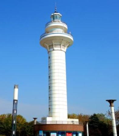
1985 (station established 1933). Active; focal plane 40 m (131 ft); white flash every 8 s; the tower is also floodlit at night. 36 m (118 ft) round cylindrical concrete tower with lantern and double gallery, centered on a circular 1-story concrete building. Lighthouse painted white with blue trim. A photo is at the top of this page, Ole Roeßler has a 2015 photo, Lee Sung Hoon has a 2011 photo, Terry Hu has a 2007 photo, Wikimedia has photos, and Google has an excellent satellite view. The lighthouse is the centerpiece of Lighthouse Square, part of a concerted effort to upgrade the city's beaches and tourist facilities. It replaced the Shíjiù lighthouse (see below); its name was changed to Rìzhào in 1992. Located just off the beach, south of a new marina and about 8 km (5 mi) north of the traditional harbor of Rìzhào. Site open, tower open daily. ARLHS PRC-056; CN-1746; Admiralty P3808; NGA 18752.
Rìzhào Coal Pier Head
Date unknown. Active; focal plane about 18 m (59 ft); continuous red light. Approx. 12 m (39 ft) round white tower. No photo available but Google has a satellite view. Located at the end of the pier. Site and tower closed. CN serial 3810045; Admiralty P3808.4; NGA 18753.7.
Rìzhào Coal Pier Range Front
Date unknown. Active; focal plane 21 m (69 ft); continuous red light. 20 m (66 ft) tapered square skeletal tower carrying a diamond-shaped daymark. No photo available but Google has a satellite view. Located near the foot of the pier. Site and tower closed. CN-1746.1; Admiralty P3808.2; NGA 18753.
Rìzhào Coal Pier Range Rear
Date unknown. Active; focal plane 29 m (95 ft); continuous red light. 28 m (92 ft) tapered square skeletal tower carrying a diamond-shaped daymark. No photo available but Google has a satellite view. Located 330 m (0.2 mi) north northwest of the front light. Site and tower closed. CN-1746.2; Admiralty P3808.21; NGA 18753.1.
* Shíjiù (Rìzhào (1))
1933. Inactive since 1985. 14 m (46 ft) 4-stage octagonal stone tower, originally painted with black and white horizontal bands. Lantern removed. A photo is at right and Google has a satellite view. Shíjiù is the traditional harbor district in downtown Rìzhào. The lighthouse was built privately by British engineers for a shipping magnate interested in developing the port. The lighthouse deteriorated over the years but it was restored in 2018. Located inside the commercial port area of Rìzhào. Site and tower closed.

Shíjiù Light, Rìzhào, August 2017
ex-Tencent News photo by Xiaobian
Shíjiù Bulk Pier
Date unknown. Active; focal plane 13 m (43 ft); white light, 2 s on, 2 s off. 8 m (26 ft) round fiberglass tower colored with red and white horizontal bands. Seong-Hoon Lee has a photo and Bing has a satellite view. Located at the end of pier in the traditional Shíjiù harbor. Site and tower closed. CN-1755.01; Admiralty P3808.1; NGA 18753.4.
Shíjiù Service Vessel Pier West
Date unknown. Active; focal plane 10 m (33 ft); green flash every 3 s. 8.5 m (28 ft) round metal tower painted with green and white horizontal bands. No photo available but Bing has a satellite view. Located on the west arm of a T-shaped pier in the traditional Shíjiù harbor. Site and tower closed. CN-1755.004; Admiralty P3808.105.
Shíjiù Service Vessel Pier East
Date unknown. Active; focal plane 10 m (33 ft); red flash every 3 s. 8.5 m (28 ft) round metal tower painted with red and white horizontal bands. No photo available but Bing has a satellite view. Located on the east arm of a T-shaped pier in the traditional Shíjiù harbor. Site and tower closed. CN-1755.003; Admiralty P3808.11.
Shíjiù West Breakwater
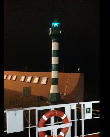
2014. Active; focal plane 19 m (62 ft); green light, 3 s on, 3 s off. 16 m (52 ft) round concrete tower with lantern and gallery. Tower painted with black and white horizontal bands. Kamal Char has the 2019 photo seen at right and Google has a satellite view. Located on the "west" (really south) breakwater of Shíjiù harbor. Site and tower closed. CN-1748.006; Admiralty P3808.09.
Shíjiù East Breakwater
2014. Active; focal plane 19 m (62 ft); red light, 3 s on, 3 s off. 16 m (52 ft) round concrete tower with lantern and gallery. Tower painted with red and white horizontal bands.. No photo available but Google has a satellite view. Located on the "east" (really north) breakwater of Shíjiù harbor. Site and tower closed. CN-1748.005; Admiralty P3808.08.
Shíjiù South Operating Area
Date unknown. Active; focal plane 13 m (43 ft); green light, 3 s on, 3 s off. 10 m (33 ft) round tower, probably colored with green and white horizontal bands. No photo available but Google has a distant satellite view. The South Operating Area is a broad quay extending about 3 km (2 mi) southward from the traditional harbor. Located on a short breakwater at the end of the quay. Site and tower closed. Admiralty P3807.3.
 

Lánshān District Lighthouses
Lánshān is a port district about 30 km (19 mi) south of Rìzhào.

Lánshān North Harbor Pierhead
Date unknown. Active; focal plane 11 m (36 ft); green light, 2 s on, 2 s off. Approx. 9 m (30 ft) post rising from a square equipment shelter. Post probably colored with green and white horizontal bands. No photo available but Google has a satellite view. Located at the end of the pier in the "North Operating Area" of Lánshān. Site and tower closed. CN sserial 3810531; Admiralty P3806.62.
Lánshān Gǎng Jetty
Date unknown. Active; focal plane about 12 m (39 ft); green flash every 3 s. Approx. 8 m (26 ft) round barbell-shaped tower, probably colored with green and white horizontal bands. No photo available but Google has a satellite view. Located on a pier inside the South Harbor. Site and tower closed. CN serial 3810511(?); Admiralty P3806.586.
Lánshān Lánqiáo General Pier
Date unknown. Active; focal plane 13 m (43 ft); white flash every 6 s. 10 m (33 ft) round concrete tower painted with black and white horizontal bands. No photo available but Google has a satellite view. Located at the south corner of a triangular quay inside the South Harbor. Site and tower closed. CN-1778.135; Admiralty P3806.59.

Shíjiù West Breakwater Light, Rìzhào, June 2019
Google Maps photo by Kamal Char
Lánshān Gǎng Oil Pier
Date unknown. Active; focal plane 14 m (46 ft); green light, 2 s on, 2 s off. 10 m (33 ft) round concrete tower painted with green and white horizontal bands. No photo available but Google has a satellite view. Located on an elbow of the east pier of the oil terminal west of the main South Harbor. Site and tower closed. CN-1777.04; Admiralty P3806.575.
Lánshān Gǎng Oil Pier Range Front
Date unknown. Active; focal plane about 25 m (82 ft); continuous yellow light. Approx. 25 m (82 ft) skeletal tower carrying a triangular daymark. No photo available but Google has a satellite view. Located in the oil terminal west of the main South Harbor. Site and tower closed. CN-1776.7; Admiralty P3806.58.
Lánshān Gǎng Oil Pier Range Rear
Date unknown. Active; focal plane 45 m (148 ft); continuous yellow light. Approx. 40 m (131 ft) skeletal tower carrying a triangular daymark. No photo available but Google has a satellite view. Located about 300 m (1/5 mi) north of the front light. Site and tower closed. CN-1776.72; Admiralty P3806.581.
Lánshān Gǎng Tónghǎi Wharf
Date unknown. Active; focal plane 15 m (49 ft); white flash every 3 s. 12 m (39 ft) round barbell-shaped tower coloered with black and white horizontal bands. No photo available but Google has a satellite view. Located on a short pier inside the oil terminal basin. Site and tower closed. CN-1776.9; Admiralty P3806.565.
Lánshān Gǎng South Breakwater
Date unknown. Active; focal plane about 24 m (79 ft); green light, pattern unknown. Approx. 20 m (66 ft) round concrete tower with lantern and gallery. No photo available but Google has a satellite view. Located on the main south (really east) of the southern basin. Site and tower closed. Admiralty P3806.45.
 

Information available on lost lighthouses:

Notable faux lighthouses:

Adjoining pages: North: Qīngdǎo | South: Liányúngǎng

Return to the Lighthouse Directory index | Ratings key

Posted March 31, 2008. Checked and revised September 7, 2023. Lighthouses: 29. Site copyright 2023 Russ Rowlett and the University of North Carolina at Chapel Hill.