Lighthouses of China: Liányúngǎng, Jiāngsū

The People's Republic of China (中华, Zhōnghuá in Chinese) has a lengthy coastline, many large harbors, and a large number of lighthouses. During the colonial period of the late 19th and early 20th centuries Western powers occupied a number of locations in China and built lighthouses, many of which survive. In more recent years the People's Republic has developed modern ports throughout the country and built many lighthouses to serve them.

The country is divided into 23 provinces and 11 other province-level regions of various special types. The province of Jiāngsū (previously spelled Kiangsu) extends southward from the base of the Shāndōng Peninsula to the mouth of the Yangtze River (Cháng Jiāng). The great port of Shànghǎi, now the center of one of the world's largest metropolitan areas, was built on the Huángpǔ River, an estuary on the south side of the Yangtze just above the mouth. Metropolitan Shànghǎi has been separated from Jiāngsū as a provincial-level metropolitan region, Shànghǎi Shì.

Jiāngsū is divided into thirteen prefectural-level cities. This page describes lighthouses of the prefectural-level city of Liányúngǎng, a city at the northern end of Jiāngsū. Liányúngǎng has become a major port relieving some of the pressure on Shànghǎi.

There are many languages and dialects spoken in China, but Standard Chinese, often called Mandarin, is official. The pīnyīn system for transliterating Standard Chinese into Latin characters is now the international standard but some locations continue to be known also under the spellings of older transliteration systems. The Chinese word for a lighthouse is dēngtǎ (灯塔). In Standard Chinese jiāo (formerly chiao) is a reef or rock, jiǎo is a cape or headland, dǎo (tao) is an island; (tsu) or tuózi ("lump") is a small island, hǎi is a sea, wān is a bay, hǎixiá is a strait, or jiāng is a river, hékǒu ("river mouth") is an estuary, and gǎng (kang) is a harbor.

Lighthouses in China are maintained by the PRC Maritime Safety Administration. The administration is organized in four regional administrations; Jiāngsū lighthouses fall under the Shànghǎi MSA.

ARLHS numbers are from the ARLHS World List of Lights. CN numbers are Chinese light list numbers, where known. Admiralty numbers are from volume P of the Admiralty List of Lights & Fog Signals. U.S. NGA List numbers are from Publication 112.

General Sources
Online List of Lights - China
Photos by various photographers posted by Alexander Trabas.
World of Lighthouses - China
Photos by various photographers available from Lightphotos.net.
Chinese English Pinyin Dictionary
A useful tool for juggling the representations of Chinese names.
Leuchttürme Chinas auf historischen Postkarten
Historic postcard images posted by Klaus Huelse.
Navionics Charts
Navigation chart for Jiāngsū.


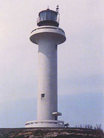
Chēniúshān Light, East China Sea
PRC Maritime Safety Administration photo

Liányún District: Qiánsān Islands Lighthouses
The Qiánsān ("Outer Three") islands in Hǎizhōu Bay are disputed between Jiāngsū and Shāndōng Provinces. They lie off the coast of Gànyú District but are administered as a township of the Liányún District.

Dáshān (Dáshāndǎo) (2?)
Date unknown. Active; focal plane 56 m (184 ft); two white flashes every 10 s. 11 m (36 ft) round cylindrical tower with lantern and gallery. Lighthouse painted with red and white horizontal bands. The lighthouse is at the far end of the island in the aerial view seen at right but Bing has only an indistinct satellite view. Located on an island in Hǎizhōu Bay about 6 km (3.5 mi) northeast of Chēniúshān (next entry). Accessible only by boat. Site status unknown. CN-2001.01; Admiralty P3806.3.
Chēniúshān (Chēniúshāndǎo) (3)
1987 (station established 1936). Active; focal plane 87 m (285 ft); white flash every 12 s. 22 m (72 ft) round cylindrical concrete tower with lantern and gallery. Lighthouse painted white, lantern red. 2-story crew and office building (1992). A Shànghǎi MSA photo is at the top of this page, Sina News has a photo, and Google has a satellite view of the station. The original lighthouse was an 8 m (26 ft) round steel tower. The second light was mounted on a triangular skeletal tower built in 1952. Chēniúshāndǎo is an island in the Hǎizhōu Bay about 50 km (30 mi) northeast of Liányúngǎng, Jiāngsū. Located on the highest point of the island. Accessible only by boat. Site status unknown. ARLHS PRC-016; CN-2001; Admiralty P3806; NGA 18756.
Niújiǎodǎo
Date unknown. Active; focal plane 16 m (52 ft); white flash every 4 s. 5 m (17 ft) concrete post mounted on a round concrete base, painted with red and white horizontal bands. No photo available but Bing has a satellite view. Located on an islet off the southwestern tip of Chēniúshāndǎo. Accessible only by boat. Site status unknown. CN-2001.02; Admiralty P3805.99.

Dáshān Light, Gànyú
Sohu.com tourist site photo

Gànyú District Lighthouses
Xiùzhēnhé Kǒu
2009. Active; focal plane 19 m (62 ft); red light, 2 s on, 2 s off. 12 m (39 ft) round concrete tower with lantern and gallery painted; lantern painted red. No photo available but Google has a satellite view. Located west of the mouth (kǒu) of the Xiùzhēn River () at the entrance to the Xiùzhēn industrial port; the river is the border between Jiāngsū and Shāndōng Provinces. Site status unknown. CN-1780; Admiralty P3805.9.
Dōnglínzihékǒu (Dōnglízi Hékǒu) West
Date unknown. Active; focal plane 12 m (39 ft); red flash every 4 s. 8 m (26 ft) hexagonal concrete tower, colored with red and white horizontal bands. No photo available but Google has a satellite view. Located at Zhèwāngzhèn, near the border with Shāndōng province. Site status unknown. CN-1780.4; Admiralty P3805.86.
Shíyánghékǒu (Shíyáng Hékǒu) East
Date unknown. Active; focal plane 16 m (52 ft); three green flashes every 10 s. 8 m (26 ft) round fiberglass tower, colored with black and white horizontal bands. No photo available but Google has a satellite view. Located at Zhèwāngzhèn about 1.8 km (1.1 mi) west of the Dōnglínzi Hékǒu light. Site status unknown. CN-1781; Admiralty P3805.85.
Shíyánghékǒu (Shíyáng Hékǒu) West
Date unknown. Active; focal plane 11 m (36 ft); three red flashes every 10 s. 8 m (26 ft) hexagonal concrete tower, colored with red and white horizontal bands. No photo available but Google has a satellite view. Located about 1 km (0.6 mi) west of the previous light. Site status unknown. CN-1781.1; Admiralty P3805.851.
Hánkǒuhékǒu (Hánkǒu Hékǒu) North
Date unknown. Active; focal plane 15 m (49 ft); one short and one long green flash every 6 s. 8 m (26 ft) square concrete tower, colored with black and white horizontal bands. No photo available but Google has a satellite view. Located on the north side of the entrance to Hánkǒu harbor, about 6.5 km (4 mi) south of the Shíyáng Hékǒu light. Site status unknown. CN-1782; Admiralty P3805.83.
Hánkǒuhékǒu (Hánkǒu Hékǒu) South
Date unknown. Active; focal plane 12 m (49 ft); two red flashes every 6 s. 8 m (26 ft) round concrete tower, colored with black and white horizontal bands. No photo available but Google has a satellite view. Located at the base of a breakwater pier on the south side of the entrance to Hánkǒu harbor. Site status unknown. CN-1783; Admiralty P3805.831.
Zhūpéngkǒu (Zhūpéng Kǒu)
Date unknown. Active; focal plane 18 m (59 ft); four red flashes every 8 s. 12 m (39 ft) round fiberglass tower, painted with red, white, and yellow horizontal bands. No photo available but Google has a satellite view. Located on the south side of an estuary entrance about 20 km (13 mi) north of Liányúngǎng. Site status unknown. CN-2002; Admiralty P3805.5.
Qínshāndǎo (Qínshān Dǎo) (1)
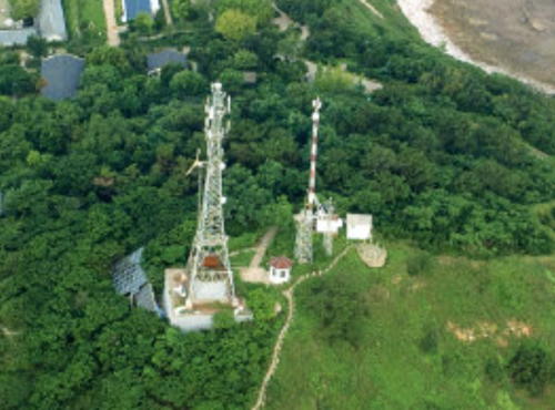
Date unknown. Inactive since about 2017. 12 m (39 ft) square skeletal tower seen in front of the red and white mast in the drone view at right. Qínshāndǎo is a tadpole-shaped island about 10 km (6 mi) off the coast of Gànyú. The island has a historic fort and is listed as a tourist attraction.
Qínshāndǎo (Qínshān Dǎo) (2)
2017 (?). Active; focal plane about 98 m (322 ft); two white flashes every 6 s. 42 m (138 ft) robust mast painted with red and white horizontal bands. A drone view is at right and Google has an indistinct satellite view of the station. Located at the east end of the island. Accessible only by boat. Site status unknown. CN-2004; Admiralty P3805.
Qínshāndǎo (Qínshān Dǎo) West
Date unknown. Active; focal plane 53 m (174 ft); two red flashes every 6 s. 52 m (171 ft) square skeletal tower. A distant photo is available and Google has a satellite view. Located on on a long sandbar trailing from the west end of the island. Site status unknown. CN-2004.01; Admiralty P3805.1.
Shāwānghékǒu (Gànyú)
Date unknown. Active; focal plane 11.5 m (37 ft); red flash every 4 s. 8 m (26 ft) round cylindrical concrete tower, painted with red and white horizontal bands. No photo available, but Google has a satellite view. Located at an irrigation and drainage facility at Gànyú, about 16 km (10 mi) north of Liányúngǎng. Site status unknown. CN-2004.03; Admiralty P3805.64.

Qínshāndǎo Light, Gànyú, December 2020
ex-Hello World tourist site photo

Liányún District: Downtown Liányúngǎng City Lighthouses
Formerly known to westerners as Haichow, Liányúngǎng was one of the first Chinese ports opened to commerce with the West. The city proper has a population of more than one million.
Línhóngkǒu (Línhóng Kǒu, Linhong Hékǒu)
Date unknown. Active; focal plane 14.5 m (48 ft); one short and one long green flash every 6 s. 8 m (26 ft) round cylindrical concrete tower with lantern and gallery, painted with black and white horizontal bands. No photo available but Google has a satellite view. Located at the entrance to a small estuary on the west side of Liányúngǎng. Site status unknown. CN-2004.1; Admiralty P3805.2.
Xīshú
Date unknown. Active; focal plane 26 m (85 ft); white flash every 4 s. 12 m (39 ft) round tower with a large lantern structure. Tower painted with red and white horizontal bands. No photo available but Google has a satellite view. Located at a small boat harbor on the west side of downtown Liányúngǎng, an area with several large hotels. Site probably open, tower closed. CN-2004.5; Admiralty P3803.43; NGA 18779.1.
Zhúdǎo (Zhú Dǎo, Bamboo Island) (2?)
Date unknown. Active; focal plane 72 m (236 ft); white flash every 4 s. 15 m (49 ft) round cylindrical concrete tower, probably with lantern and gallery, painted with green and white horizontal bands. A drone view is at right, Komo Guo has a very distant view from the beach, another distant view is available, and Google has a satellite view. Located on Zhúdǎo, a small island off the Xūgōu district of Liányúngǎng. Accessible only by boat. Site status unknown. CN-2004.8; Admiralty P3803.3; NGA 18779.2.
Xūgōu Range Front (3 towers)
Date unknown. Active; focal plane 50 m (164 ft); continuous red light. 49 m (160 ft) triangular pyramidal skeletal tower with gallery, one of three identical towers. The towers carry a hexagonal daymark, painted white with a black vertical stripe on the range line. A sunrise photo is available and Bing has a satellite view that shows the three towers. These towers define the right side, center, and left side of the third entrance range guiding ships into the inner harbor. Located on a pier projecting into the west end of Liányúngǎng's eastern harbor. Site status unknown. CN-2027.5, Admiralty P3803.4, NGA 18779.3 (center); CN-2027.52, P3803.42 (south limit); and CN-2027.54; P3803.425 (north limit).

Zhúdǎo Light, Liányúngǎng
Guǎngxī Zhuàng Regional Government photo
* Xūgōu Range Rear (3 towers)
Date unknown. Active; focal plane 81 m (266 ft); continuous red light. 24 m (79 ft) square skeletal tower atop a round cylindrical concrete tower with gallery, one of three identical towers. The tower carries a hexagonal daymark, painted white with a black vertical stripe on the range line. No photo available but Bing has the satellite view seen at right showing all three towers. As in the case of the front range, these towers define the right side, center, and left side of the entrance channel. Located 1330 m (0.83 mi) due west of the front light, on the rocky peninsula that separates Liányúngǎng's traditional western harbor from its newer east harbor. Site open, tower status unknown. CN-2027.51, Admiralty P3803.41, NGA 18779.31 (center); CN-2027.53, P3803.421 (south limit;, and CN-2027.55, P3803.426 (north limit).
Xīdàdī (West Breakwater) Range Front
Date unknown. Active; focal plane 31 m (102 ft); red light, 1 s on, 1 s off. 28 m (92 ft) tapered square skeletal tower carrying a large red and white daymark. No photo available but Bing has a satellite view. This is the second entrance range guiding vessels entering the harbor of Liányúngǎng. Located south of the causeway connecting Liányúngǎng to Yángwōdǎo. Accessible only by boat, but easily seen from shore. Site status unknown. CN-2005.04; Admiralty P3803.25; NGA 18778.5.
Xīdàdī (West Breakwater) Range Rear
Date unknown. Active; focal plane 53 m (174 ft); red light, 1 s on, 1 s off. 48.5 m (159 ft) tapered square skeletal tower carrying a large red and white daymark. No photo available but Google has a satellite view. Located on the south side of the causeway connecting Liányúngǎng to Shuǐdǎo, 864 m (0.54 mi) northwest of the front light. Accessible only by boat, but easily seen from shore. Site status unknown. CN-2005.05; Admiralty P3803.251; NGA 18778.55.
Basin No. 1 Range Front
Date unknown. Active; focal plane 21 m (69 ft); quick-flashing red light. 19 m (62 ft) skeletal tower painted red and carrying a rectangular daymark painted black with a white vertical stripe. No photo available but Google has a satellite view. Located at the foot of one of main harbor basins. Site and tower closed. CN-2029; Admiralty P3803; NGA 18778.13.
Basin No. 1 Range Rear
Date unknown. Active; focal plane 26 m (85 ft); quick-flashing red light. 13 m (43 ft) skeletal tower painted red and carrying a rectangular daymark painted black with a white vertical stripe. No photo available but Google has a satellite view. Located beside an expressway 159 m (520 ft) southwest of the front light. Site and tower closed. CN-2030; Admiralty P3803.1; NGA 18778.15.

Xūgōu Range Rear Lights, Liányúngǎng
Bing Maps satellite view

Liányún District: Liándǎo Lighthouses
Liándǎo is an island sheltering the north side of the entrance to Liányúngǎng harbor. The 10 km (6 mi) long Xīdàdī causeway, China's longest sea dike, provides access to the island as well as acting as a seawall protecting the inner harbor. The north side of the island has very popular beaches.

#Xīliándǎo (West Liándǎo) Breakwater
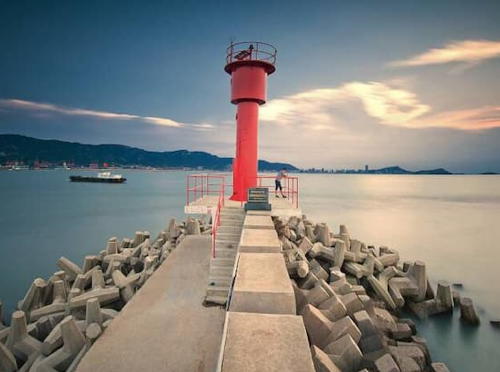
Date unknown. Apparently removed. This was a 9 m (30 ft) steel tower painted red. A photo is at right and Bing has an indistinct satellite view. Google Earth images show this light is no longer present. Located on a short breakwater sheltering the fishing harbor at Xīliándao (West Líándǎo) at the west end of Líándǎo. Site status unknown. CN-2004.6; Admiralty P3803.2; NGA 18765.
Líándǎo Jídī West
Date unknown. Active; focal plane about 15 m (49 ft); white light, pattern unknown. Approx. 12 m red barbell-shaped tower. No photo available but Google has a satellite view. Located at the west end of the MSA district base on the south side of Líándǎo facing the north side of the harbor. Site status unknown. Admiralty P3803.45.
Shuǐdǎo Range Front
Date unknown. Active; focal plane 91 m (299 ft); red light, 1 s on, 1 s off. 13 m (43 ft) triangular skeletal tower carrying a rectangular daymark painted white with a red vertical stripe. No photo available but Google has an indistinct satellite view. This is an exit range guiding ships departing the inner harbor. Located on heights on the south side of Liándǎo. Site status unknown. CN-2027.46; Admiralty P3803.6; NGA 18778.6.
Shuǐdǎo Range Rear
Date unknown. Active; focal plane 126 m (413 ft); red light, 1 s on, 1 s off. 28 m (92 ft) triangular skeletal tower carrying a rectangular daymark painted white with a red vertical stripe. No photo available but Bing has an indistinct satellite view. Located on heights on the south side of Liándǎo. Site status unknown. CN-2027.48; Admiralty P3803.61; NGA 18778.7.


Xīliándǎo Breakwater Light, Liányúngǎng
unattributed photo posted by Chinese Airbnb
* Yángwōtóu (Yángwōdǎo) ("Sheep Pen Head") (3)
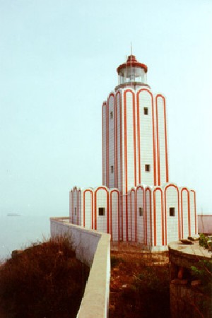
1995 (station established 1936). Active; focal plane 125 m (410 ft); three white flashes every 20 s. 16 m (52 ft) robust square cylindrical concrete tower with lantern and gallery, rising from a cross-shaped 1-story keeper's house. The lighthouse, covered with tiles, is white with narrow red vertical stripes as shown in the photo at right; lantern painted red. An undated MSA photo is at right, Shi Xiaofeng has a distant view, and Google has a satellite view. The lack of photos of this major lighthouse is surprising. The original lighthouse was replaced in 1957. Located at the east end of the island. Site probably open, tower closed. ARLHS PRC-070; CN-2006; Admiralty P3804; NGA 18760.

Liányún District: Approach Lighthouses
Liányúngǎng Entrance North Breakwater
Date unknown. Active; focal plane 21 m (69 ft); white light, 1 s on, 1 s off. 12 m (39 ft) round cylindrical concrete tower painted white with narrow green horizontal bands. No photo available but Google has a satellite view. Located at the end of the main north breakwater protecting the entrance to Liányúngǎng. Site status unknown. CN-2007.13; Admiralty P3800.64; NGA 18777.5.
Liányúngǎng Entrance South Breakwater
Date unknown. Active; focal plane 21 m (69 ft); white light, 1 s on, 1 s off. 12 m (39 ft) round cylindrical concrete tower painted white with narrow red horizontal bands. No photo available but Google has a satellite view. Located at the end of the main south breakwater protecting the entrance to Liányúngǎng. Site status unknown. CN-2007.14; Admiralty P3800.65; NGA 18777.6.
Liányúngǎng Main Channel A Range Front
1993. Active; focal plane 27.5 m (90 ft); white light, 2 s on, 2 s off, synchronized with the rear light. 22 m (72 ft) tapered square skeletal tower with gallery and a diamond-shaped daymark, mounted on a square platform supported by piles. No photo available but Google has a satellite view revealing that the area around the light has been filled. This is the first entrance range for ships arriving in Liányúngǎng. Located south of Yángwōdǎo. Site status unknown. CN-2007; Admiralty P3800.7; NGA 18777.
Liányúngǎng Main Channel A Range Outer Rear
1993. Active; focal plane 65 m (213 ft); white light, 2 s on, 2 s off, synchronized with the front light. 48 m (157 ft) tapered square skeletal tower with gallery and a diamond-shaped daymark. No photo available but Google has a satellite view. Located onshore about 1.47 km (0.9 mi) southwest of the front light. Site status unknown. CN-2007.01; Admiralty P3800.71; NGA 18777.1.
Liányúngǎng Main Channel A Range Inner Rear
1993 (?). Active; focal plane 86 m (282 ft); red light, 2 s on, 2 s off. 14 m (46 ft) square skeletal tower. No photo available but Google has a satellite view. Located up a steep slope about 250 m (820 ft) behind the Outer Rear Light. Site status unknown. CN-2007.1; Admiralty P3800.711.
Yangwotou Light
Yángwōtóu Light, Liányúngǎng
PRC Maritime Safety Administration photo
Liányúngǎng Main Channel B Range Front
Date unknown. Active; focal plane 16.5 m (54 ft); continuous red light. 16.5 m (54 ft) square skeletal tower mounted on a square platform supported by concrete piles. No photo available but Google has a satellite view. This is the second exit range guiding vessels leaving the harbor of Liányúngǎng. Located just inside the south outer breakwater of the harbor. Accessible only by boat, but easily seen from shore. Site status unknown. CN-2008; Admiralty P3800.8; ex-NGA 18778.
Liányúngǎng Main Channel B Range Rear
Date unknown. Active; focal plane 27 m (89 ft); continuous red light. 27 m (89 ft) square skeletal tower mounted on a square platform supported by concrete piles. No photo available but Google has a satellite view. Located 810 m (1/2 mi) southeast of the front light. Accessible only by boat. Site status unknown. CN-2008.1; Admiralty P3800.81; ex-NGA 18778.1.
Yángshāndǎo (Yángshān Dǎo) (2?)
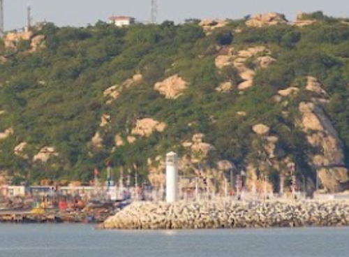
2009. Active; focal plane 18 m (56 ft); red light, 2 s on, 2 s off. 12 m (39 ft) round cylindrical white fiberglass tower. A 2016 view from the sea (also seen at right) is available and Google has a satellite view. Sometime after 2013 the breakwater was extended and the light relocated to the end of the extension. Yángshāndǎo is a small island, now joined to the mainland by fill, at the southeastern edge of Liányúngǎng. Located at the end of a pier projecting from the south side of the island. Probably accessible by walking the pier. Site open, tower closed. CN-2041.17; Admiralty P3800.912.
Tiānwān Breakwater Middle
Date unknown. Active; focal plane 13.5 m (44 ft); four yellow flashes in a long-short-long-short pattern every 12 s. 10 m (33 ft) yellow metal tower. No photo available but Google has a satellite view. Located in the curve of a curved breakwater extending from the Tiānwān Nuclear Power Plant in the south harbor. Site status unknown. CN serial 4110872; Admiralty P3800.99.

Yángshāndǎo Light, Liányúngǎng
Google Maps photo by yz Zhang
Tiānwān Breakwater Head
Date unknown. Active; focal plane 13.5 m (44 ft); four yellow flashes in a long-short-long-short pattern every 12 s. 10 m (33 ft) yellow metal tower. No photo available but Google has a satellite view. Located at the end of the curved Tiānwān Breakwater. Site status unknown. CN serial 4110871; Admiralty P3800.98.
Xúwéi Range Front
Date unknown. Active; focal plane 30 m (98 ft); red light, 1 s on, 1 s off. 30 m (98 ft) square skeletal tower mounted on a square platform supported by piles and carrying a rectangular daymark painted with black and white vertical stripes. No photo available but Google has a satellite view. This is an approach range for the Xúwéi harbor in southern Liányúngǎng. Located offshore about 20 km (13 mi) southeast of Yángwōdǎo. Accessible only by boat. Site open, tower closed. CN-2041.61; Admiralty P3799.505; NGA 18779.312.
Xúwéi Range Rear
Date unknown. Active; focal plane 51 m (167 ft); red light, 1 s on, 1 s off. 54 m (177 ft) square skeletal tower carrying a rectangular daymark painted with black and white vertical stripes. No photo available, but Google has a satellite view. Located onshore at Xúwéi about 2 km (1.25 mi) southwest of the front light. Site status unknown. CN-2041.62; Admiralty P3799.506; NGA 18779.313.
 

Guànyún County Lighthouses
* Yànwěi Gǎng (2?)
Date unknown. Active; focal plane 14 m (46 ft); three green flashes every 10 s. 8 m (26 ft) round cylindrical concrete tower, painted with black and white horizontal bands. No photo available but Bing has a satellite view. Located on the north side of the entrance to Yànwěi, a small port at the mouth of the Guànhé river opposite Kāishāndǎo. Site open, tower closed. CN-2047; Admiralty P3799; NGA 18779.318.
Kāishāndǎo (3)
1995 (station establishment date unknown). Active; focal plane 47 m (151 ft); white flash every 5 s. 12.5 m (41 ft) two-stage round cylindrical concrete tower with lantern and gallery. Lighthouse covered with tiles colored white with red trim. A photo is at right, Lester Xu has a 2013 closeup photo, and Bing has a satellite view. A 2019 photo shows party faithful saluting the memory of longtime keeper Wang Jicai. This is the first full-size lighthouse at this location; a small post light was removed in 1991 and replaced in 1993 by a 5 m (17 ft) skeletal tower. The lantern was added during a restoration in 2022-23. Kāishāndǎo is a small island in the Yellow Sea about 45 km (27 mi) east of Liányúngǎng and 20 km (12.5 mi) northeast of the mouth of the Guànhé river. Located on the highest point of the island. Site status unknown. CN-2042; Admiralty P3798; NGA 18779.32.

Kāishāndǎo Light, Liányúngǎng, June 2023
Liányúngǎng City government photo

Information available on lost lighthouses:

Notable faux lighthouses:

Adjoining pages: North: Rìzhào | South: Yánchéng and Nántōng

Return to the Lighthouse Directory index | Ratings key

Posted April 21, 2008. Checked and revised September 14, 2023. Lighthouses: 41. Site copyright 2023 Russ Rowlett and the University of North Carolina at Chapel Hill.