Lighthouses of China: Wēnzhōu Area (Southern Zhèjiāng)

The People's Republic of China (PRC), known officially as Zhōnghuá (中华), has a lengthy coastline, many large harbors, and a large number of lighthouses. The country is divided into 23 provinces and 11 other province-level regions of various special types. The Chinese province of Zhèjiāng (formerly spelled Chekiang) occupies the central coast of the country, south of Shànghǎi and north of the Formosa Strait. The province faces east on the East China Sea. The coastline is hilly and irregular, with more than 3000 islands of all sizes offshore.

Zhèjiāng is divided into eleven prefectural-level cities. This page lists lighthouses in the northern half of the prefectural-level city of Wēnzhōu in southern Zhèjiāng Province, including the important port of Wēnzhōu and the islands of the Dòngtóu District. This area did not attract much foreign interest during the colonial period. Although Wēnzhōu was a treaty port that shipped tea to Europe the European powers built very few lighthouses in the area. As a result nearly all the lights listed are of recent origin and modern design.

Lighthouses in China are maintained by the PRC Maritime Safety Administration. The administration is organized in four regional administrations, with district offices in the major ports. All the lights on this page are maintained by the Wēnzhōu MSA office, which is part of the Shànghǎi Region.

There are many languages and dialects spoken in China, but Standard Chinese, often called Mandarin, is official. The pīnyīn system for transliterating Standard Chinese into Latin characters is now the international standard but some locations continue to be known also under the spellings of older transliteration systems. The Chinese word for a lighthouse is dēngtǎ (灯塔). In Standard Chinese jiāo (formerly chiao) is a reef or rock, jiǎo is a cape or headland, dǎo (tao) is an island; (tsu) or tuózi ("lump") is a small island, hǎi is a sea, wān is a bay, hǎixiá is a strait, or jiāng is a river, hékǒu ("river mouth") is an estuary, and gǎng (kang) is a harbor.

ARLHS numbers are from the ARLHS World List of Lights. CN numbers are the MSA List of Lights (助航标志表) numbers. Admiralty numbers are from volume P of the Admiralty List of Lights & Fog Signals. U.S. NGA List numbers are from Publication 112.

General Sources
Online List of Lights - China
Photos by various photographers posted by Alexander Trabas.
Chinese English Pinyin Dictionary
A useful tool for juggling the representations of Chinese names.
Navionics Charts
Navigation chart for Zhèjiāng,

Qitou Light
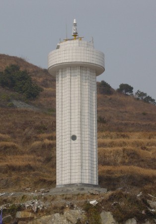
Qítóu (Wēnzhōu Point) Light, Wēnzhōu
PRC MSA Shànghǎi Region photo
Northern Dòngtóu District (Dàméndǎo Area) Lighthouses
The Dòngtóu District includes a ragged archipelago of 168 islands lying across the approaches to the port of Wēnzhōu.

Xiǎowūxīng Yǔ
Date unknown. Active; focal plane 21 m (62 ft); white flash every 3 s. 7.5 m (25 ft) round concrete tower, painted with red and white horizontal bands. No photo available but Google has a satellite view. Located on a small island about 5 km (3 mi) north of Dàméndǎo. Accessible only by boat. Site status unknown. CN-2718; Admiralty P3661.3.
Dòngtóu (Dòng Tóu, Damen Dao East Point) (3)
1996 (station established 1955). Active; focal plane 39 m (128 ft); two white flashes every 6 s. 10 m (33 ft) round cylindrical concrete tower with gallery, covered with white ceramic tiles. No photo available but Google has a satellite view. Dàméndǎo is the largest island in Wēnzhōu Bay, about 11 km (5.5 mi) long; since it is inhabited the lighthouse may be accessible. Located at the eastern tip of Dàméndǎo. Site status unknown. CN-2702; Admiralty P3661; NGA 19068.
Māoshān Yǔ
Date unknown. Active; focal plane 47 m (154 ft); three white flashes every 10 s. 13 m (43 ft) round white concrete tower with gallery. No photo available but Google has a satellite view. Located on a small island off the southern tip of Lùxīdǎo, an island east of Dàméndǎo. Accessible only by boat. Site status unknown. CN-2716.5; Admiralty P3660.6.
Qīnglíng Yǔ
Date unknown. Active; focal plane 22 m (72 ft); white flash every 4 s. 8.5 m (28 ft) round white concrete tower with gallery. No photo available but Bing has a fuzzy satellite view. Located on a small island off the southern side of Dàméndǎo. Accessible only by boat. Site status unknown. CN-2721.7; Admiralty P3661.8.
Xiàwūxiānzuǐtóu (Huangda Zui) (2)
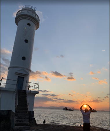
Date unknown. Active; focal plane 14 m (46 ft); two white flashes every 6 s. 12.5 m (41 ft) round concrete tower with gallery. Patrick Prendergast has the closeup photo seen at right, Jamaluddin Ote has a view from the sea, and Bing has a satellite view. Located on the southwestern tip of Dàméndǎo. Site status unknown. CN-2729; Admiralty P3661.5; NGA 19072.

Xiàwūxiānzuǐtóu Light, Dàméndǎo, September 2019
Google Maps photo by Patrick Prendergast

Ōu Estuary (Wēnzhōu Harbor) Northside: Yuèqīng City Lighthouses
Wēnzhōu is a major port on the estuary of the Ōu River (Ōujiāng). During the colonial era it was a treaty port, open to Westerners, but it never had any substantial Western settlement. During World War II it was one of the few ports on the central Chinese coast not captured by Japanese forces. The city has a population of about 3 million.
Bànyángjiāo
Date unknown. Active; focal plane 7.5 m (25 ft); two white flashes every 5 s. 10 m (33 ft) round cylindrical concrete tower painted black with one red horizontal band. No photo available but Google has a satellite view. Located on a reef off the north side side of the entrance to the Ōu estuary leading to Wēnzhōu harbor. Accessible only by boat. Site open, tower closed. CN-2730; Admiralty P3661.492.
Qítóu (Wēnzhōu Point, Wēnzhōu Jiǎo) (2)
2004 (station establishment date unknown). Active; focal plane 20 m (66 ft); two white flashes every 6 s. 13 m (43 ft) round fluted cylindrical concrete tower with gallery, covered with white ceramic tiles. MSA's photo is at the top of this page and Google has a satellite view. The original light was mounted on a short domed tower. That tower was probably at a much higher location than the present light; we need information on its history. Located on a promontory on the north side of the entrance to the Ōu estuary leading to Wēnzhōu harbor. Site status unknown, possibly accessible. CN-2734; Admiralty P3662; NGA 19020.
Cāngxià (2)
Date unknown. Active; focal plane 11 m (36 ft); two white flashes every 6 s. 8.5 m (28 ft) round white concrete tower. No photo available but Google has a satellite view. Located on the north side of the estuary opposite the west end of Wēnzhōudǎo, an island in the mouth of the Ōujiāng. Site status unknown. CN-2736; Admiralty P3662.4; NGA 19048.
* Mǎtíshān (Mǎtí Shān) (2)
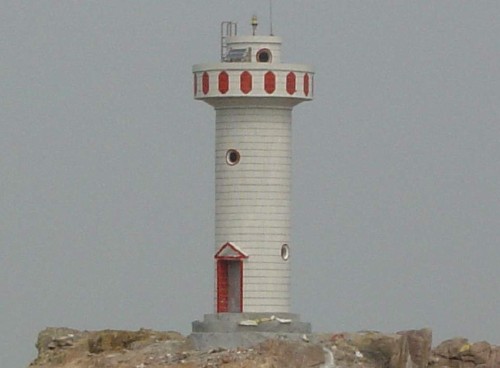
2002 (station establishment date unknown). Active; focal plane 13 m (43 ft); white flash every 3 s. 11 m (36 ft) hexagonal cylindrical concrete tower with gallery, covered with ceramic tiles colored in red and white horizontal bands. An MSA photo is at right and Google has an indistinct satellite view. The lighthouse marks a narrow section in the approach to Wēnzhōu. Located on the north side of the estuary opposite Qīdū island. This site appears to be accessible by a road along the shore. Site open, tower closed. CN-2740; Admiralty P3662.7; NGA 19066.

Mǎtíshān Light, Wēnzhōu
PRC Maritime Safety Administration Shànghǎi Region photo

Ōu Estuary (Wēnzhōu Harbor) Upper Southside: Lùchéng District Lighthouses
Qīdū Zuǐ
Date unknown. Active; focal plane 9 m (30 ft); three white flashes every 10 s. 10 m (33 ft) round white concrete tower with gallery. No photo available but Google has a satellite view. Located just off the northwestern tip of Qīdū island. Site open, tower closed. CN-2743; Admiralty P3662.8; NGA 19067.
Xiàngyán (2)
Date unknown. Active; focal plane 15 m (49 ft); two white flashes every 6 s. 8 m (26 ft) round cylindrical unpainted white concrete tower with gallery, mounted on a round, stepped concrete pier. A photo is available and Google has a satellite view. Located at the end of a shoal off the southeastern tip of Jiāngxīn island in Wēnzhōu. Accessible only by boat. Site open, tower closed. CN-2777; Admiralty P3663.5; NGA 19064.
* [Jiāngxīnyǔ East Pagoda]
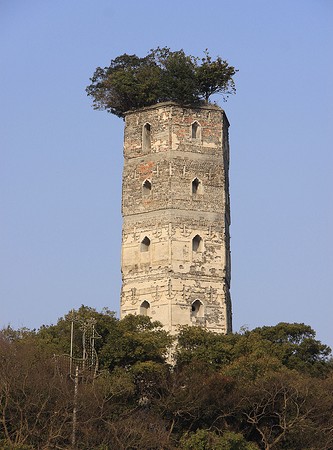
869 AD. Inactive. Hexagonal stone pagoda, now partially in ruins. Steve Byrne's photo is at right, snow dusts the trees in a December 2010 photo, a distant view is available, and Google has a satellite view. According to Wēnzhōu County annals this Táng Dynasty pagoda was built as a daybeacon for sailors arriving in Wēnzhōu. In 1981 both Jiāngxīnyǔ pagodas were listed as National Cultural Heritage sites. Located at the eastern end of Jiāngxīn island in Wēnzhōu. Transportation to the island is available. Site open, tower closed.
* [Jiāngxīnyǔ West Pagoda]
969 AD. Inactive. Hexagonal stone pagoda, in good condition, with five balconies and a pyramidal roof. Barış Tuğgan has a photo, a 2018 photo is available, and Google has a satellite view. The second pagoda, built exactly 100 years after the first, provided sailors with a range line in their approach to Wēnzhōu. In 1981, both Jiāngxīnyǔ pagodas were listed as National Cultural Heritage sites. Located at the eastern end of Jiāngxīn island in Wēnzhōu. Transportation to the island is available. Site open, tower closed.
Yánménshān (Yánmén Shān) (2) (?)
2002 (station establishment date unknown). Inactive; possibly removed. 11 m (36 ft) round cylindrical concrete tower with gallery, covered with white ceramic tiles. No photo available but Google has a satellite view. This light has been dropped from the Admiralty list. Located at the toe of a rocky promontory projecting into the south (here, really the west) side of the estuary a few miles northwest of Wēnzhōu. Site status unknown, possibly accessible. CN-2779.14; ex-Admiralty P3663.9.

Ōu Estuary (Wēnzhōu Harbor) Lower Southside: Lóngwān District Lighthouse
Lóngwān Pàotái (Longwan Fort, Lóngwāntóu)
Date unknown. Active; focal plane 13 m (43 ft); four white flashes every 10 s. 6 m (20 ft) round cylindrical concrete tower with a domed top; the light is mounted atop the dome. Lighthouse painted white. No photo available but Google has a satellite view. This lighthouse is a sibling of the original Qítóu lighthouse. It is built below the historic Lóngwān fort, which protected Wēnzhōu against attack by pirates. Located on a promontory on the south side of the estuary at Lóngwān. Site status unknown, possibly accessible. CN-2738; Admiralty P3662.6; NGA 19052.
Jiangxinyu East Pagoda
Jiāngxīnyǔ East Pagoda, Wēnzhōu, January 2010
Flickr photo copyright Steve Byrne; used by permission

Southern Dòngtóu District Lighthouses
Běiyuányǔ (Běiyuán Yǔ, North Round Island) (3)
2001 (station established 1955). Active; focal plane 44 m (144 ft); three white flashes every 10 s. 13 m (43 ft) round cylindrical concrete tower with gallery, covered with white ceramic tiles. NGA describes a 12 m (39 ft) round conical stone tower, presumably the 1976 lighthouse. No photo available but Google has a satellite view. This lighthouse marks a dangerous reef at the start of the deepwater approach to Wēnzhōu from the east. Located on a small island about 7 km (4 mi) southeast of the inhabited island of Lùxīdǎo. Accessible only by boat. Site status unknown. CN-2717; Admiralty P3660.4; NGA 19076.
Dàbǐjiàyǔ (Dàbǐjià Yǔ)
Date unknown. Active; focal plane 48 m (158 ft); white flash every 4 s. 9 m (30 ft) round white concrete tower. This light is atop the steep island on the right in Jamaluddin Ote's distant view (a portion is seen at right) and Google has a distant satellite view. Located on a reef on the south side of the Wēnzhōu entrance channel about 7 km (4.5 mi) southwest of Běiyuányǔ. Accessible only by boat. Site status unknown. CN-2721.3; Admiralty P3660.9.
Xiǎoyuányǔ (Yuán Yǔ, "Little Round Island")
Date unknown. Active; focal plane 24 m (79 ft); two white flashes every 6 s. 9 m (30 ft) round white concrete tower. This light is atop the distant island in the center in Jamaluddin Ote's distant view and Google has a distant satellite view. Located on a small island about 1.6 km (1 mi) southwest of Dàbǐjiàyǔ. Despite its name the island is not round. Accessible only by boat. Site status unknown. CN-2721.5; Admiralty P3660.95.

Dàbǐjià Yǔ Light, Dòngtóu, August 2021
Google Maps photo by Jamaluddin Ote
Lǎoshǔyǔ ("Rat Island")
Date unknown. Active; focal plane 35.5 m (117 ft); white flash every 6 s. 7.5 m (25 ft) round concrete tower painted with red and white horizontal bands. This light is barely visible on the left in Jamaluddin Ote's distant view and Google has a distant satellite view. Located on a small island about 1 km (0.6 mi) south of Xiǎoyuányǔ. Accessible only by boat. Site status unknown. CN-2779.4; Admiralty P3660.97.
Lìyán (Lì Yǔ, Zhuàngyuán'ào Shān) (2)
2002 (station established 1954). Active; focal plane 17 m (56 ft); white flash every 4 s. 10 m (33 ft) round cylindrical concrete tower with gallery, covered with ceramic tiles colored white with red trim. MSA's photo is at right and Google has a street view and a satellite view. Zhuàngyuán'ào is an inhabited island on the north side of the Dòngtóu Channel. The light guides vessels approaching bridges that connect Zhuàngyuán'ào to the neighboring island of Qiánménshān to the west. Located off the western tip of Zhuàngyuán'ào. Accessible only by boat. Site open, tower closed. CN-2784; Admiralty P3657.82.
Dàsānpándǎo (Dàsānpán Dǎo, Tasanpang Shan) (2)
2003 (station established 1955). Active; focal plane 53 m (174 ft); three white flashes every 10 s. 8 m (26 ft) round cylindrical concrete tower with gallery, covered with ceramic tiles colored white with red trim. No photo available but Google has a satellite view. The 2016 Chinese list describes the original light, a small pyramidal structure. Dàsānpándǎo is a small but inhabited island in the Dòngtóu Channel, one of the approaches to Wēnzhōu. Located on the highest point of the island. Site status unknown, but probably accessible. CN-2782; Admiralty P3660.2.
Luàntóuyǔ (Luàntóu Yǔ)
2007. Active; focal plane 23 m (75 ft); white flash every 3 s. 8 m (26 ft) round concrete tower, painted with red and white horizontal bands. The light is centered in a fuzzy Google street view and Google also has a fuzzy satellite view. Located on a small island in the channel between Dòngtóudǎo and Dàsānpándǎo. Accessible only by boat. Site status unknown. CN-2780.6; Admiralty P3660.1.
Liyan Light
Liyan Light, Dòngtóu
PRC Maritime Safety Administration Shànghǎi Region photo
Guānchaoshān
Date unknown. Active; focal plane 12 m (39 ft); two white flashes every 6 s. 8.5 m (28 ft) concrete tower painted with red and white horizontal bands. No photo available but Google has a distant satellite view. Located at the northern tip of an island about 1.5 km (1 mi) southeast of Dàsānpándǎo. Accessible only by boat. Site status unknown. CN-2780.5; Admiralty P3659.8.
Hǔtóuyǔ (Hutou Yu)
Date unknown. Active; focal plane 103 m (338 ft); two white flashes every 6 s. 8.5 m (28 ft) square pyramidal white concrete tower. No photo available; Google has a distant satellite view. Located on an island well out into the East China Sea, about 7 km (4.5 mi) east of Dòngtóudǎo. Accessible only by boat. Site status unknown. CN-2780; Admiralty P3659; NGA 19084.
 
Xiàngzǎiyǔ
Date unknown. Active; focal plane 20 m (66 ft); three white flashes every 10 s. 7.5 m (25 ft) white concrete tower. A photo is at right and Google has a satellite view. Located on a small island just off the southeastern coast of Dòngtóudǎo. Accessible only by boat. Site status unknown. CN-2789.5; Admiralty P3658.3.
Bànguānyǔ
Date unknown. Active; focal plane 19 m (62 ft); two white flashes every 4 s. 8 m (26 ft) white concrete tower. No photo available but Google has an indistinct satellite view. Located on a small island just off the southeastern coast of Bàngpíngdǎo., an island just south of Dòngtóudǎo. Accessible only by boat. Site status unknown. CN-2791.4; Admiralty P3657.3; NGA 19084.8.
Niúbíyǔ ("Cownose Island")
Date unknown. Active; focal plane 10 m (33 ft); white flash every 5 s. 8 m (26 ft) concrete tower painted with red and white horizontal bands. No photo available but Bing has an indistinct satellite view. Located on a small island just off the southwestern coast of Bàngpíngdǎo., an island just south of Dòngtóudǎo. Accessible only by boat. Site status unknown. CN-2791.3; Admiralty P3657.4; NGA 19084.3.
Běicèdǎo (Běi Cèdǎo, Beitse Shan) (2)
1993 (station established 1963). Active; focal plane 28 m (92 ft); white flash every 4 s. 8.5 m (28 ft) hexagonal cylindrical concrete tower with gallery, covered with white ceramic tiles. No photo available but Google has a satellite view. Located atop Běicèdǎo, northernmost of the Cè (Tse) Islands, a small group south of Dòngtóudǎo. Accessible only by boat. Site status unknown. CN-2792; Admiralty P3657.5.
Méihuājiāo (Méihuā Jiāo) (2)
1997 (station established 1954). Active; focal plane 17 m (56 ft); white flash every 4 s. 12.5 m (41 ft) hexagonal cylindrical concrete tower with gallery, covered with ceramic tiles colored black. No photo available but Google has an indistinct satellite view. Located on a reef off the western tip of Dòngtóudǎo. Accessible only by boat. Site status unknown. CN-2786; Admiralty P3657.7.

Xiàngzǎiyǔ Light, Dòngtóu
Google Maps photo by Mr. Sài dé
Xiǎoqúdǎo (Xiǎoqú Dǎo)
Date unknown. Active; focal plane 13 m (43 ft); three white flashes every 10 s. 8 m (26 ft) round white concrete tower. No photo available but Google has an indistinct satellite view. Located on a small island off the southwestern tip of Xiǎoqúdǎo. Accessible only by boat. Site status unknown. CN-2791.2; Admiralty P3657.6.
Qīcáobítóu (2)
Date unknown. Active; focal plane 18 m (59 ft); two white flashes every 6 s. 8 m (26 ft) round white concrete tower. No photo available but Google has an indistinct satellite view. NGA lists a 5 m (16 ft) skeletal tower for this light. Located at the southwestern tip of Dàqúdǎo. Accessible only by boat. Site status unknown. CN-2792.5; Admiralty P3657.57; NGA 19084.5.
Lóngyǎnjiāo (Longanjiao) (2)
1960 (station established 1955). Active; focal plane 12 m (39 ft); four white flashes every 12 s. 12.5 m (41 ft) hexagonal cylindrical concrete tower with gallery, covered with white ceramic tiles. No photo available but Google has a satellite view. Located on a dangerous reef on the approach to Wēnzhōu from the southeast, about 10 km (6 mi) southwest of Níyǔshān. Site status unknown. CN-2793; Admiralty P3657.75.
Fùdǐngjiāo (Fùdǐng Jiāo)
Date unknown. Active; focal plane 19 m (62 ft); two white flashes every 6 s. 12 m (39 ft) round concrete tower colored with red and white horizontal bands. No photo available but Bing has a satellite view. Located on an islet about 16 km (10 mi) south of Dòngtóudǎo. Accessible only by boat. Site status unknown. CN-2793.7; Admiralty P3657.56; NGA 19084.7.
Běibǎiyǔ
Date unknown. Active; focal plane 37 m (121 ft); white flash every 6 s. 8.5 m (28 ft) concrete tower colored with red and white horizontal bands. No photo available but Google has a satellite view. Located on an islet at the extreme southern end of the Dòngtóu group. Accessible only by boat. Site status unknown. CN-2794.005; Admiralty P3657.54.

Information available on lost lighthouses:

Notable faux lighthouses:

Adjoining pages: North: Southern Tàizhōu | South: Ruì'ān Area

Return to the Lighthouse Directory index | Ratings key

Posted June 9, 2008. Checked and revised December 18, 2023. Lighthouses: 33. Site copyright 2023 Russ Rowlett and the University of North Carolina at Chapel Hill.